Open Trip Planner lets you plan trips mixing transit, walking and biking into a single itinerary.
You can customize all trips by moving a circle inside a triangle, adjusting for time, hills and safety. You even get elevation profiles from the USGS, which should help people determine which parts of the route might be harder to bike and walk.
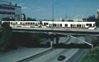
Two units cross the
Interstate 405 freeway
on Morrison Street. One
heading east and the other west.
Washington Park MAX station is the deepest in North America at 260 ft below ground. This is MAX's only below ground station.
The Portland History Web site has interesting photos and stories about Oregon trains.
Northwest Virtual Transit Center
The site (not affiliated with any transit authority) covers the entire Pacific Northwest including Portland, Spokane, and Seattle. It covers future transit projects.
A self-propelled Diesel
Multiple Unit (DMU).
Streetcar rider ship has exceeded forecasts.
Next
Streetcar
9
minutes
23
minutes
37
minutes
51
minutes
971-404-2972
Code: 4509
NextBus uses Global Positioning System (GPS) tracking satellites to provide streetcar arrival information and real-time maps for Portland Streetcars passengers.
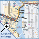
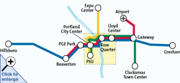
Transit Map
Click to Enlarge
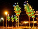
The goal of TriMet's public art program is to promote increased transit usage and community pride by integrating temporary and permanent art works into TriMet's public transit system, thereby celebrating the contributions of public transportation and recognizing the cultural richness in the region.
An artist rendering of the new MAX trains for the Green Line. TriMet has ordered 21 new MAX trains from Siemens Transportation Systems for the I-205/Portland Mall MAX Light Rail Project scheduled to begin in 2009.
Keep Portland Moving began as a multi-agency effort to coordinate large public projects to reduce traffic impacts. Today it includes a Portland Office of Transportation campaign to help promote a vibrant, accessible downtown Portland, both short term and in the long run, by minimizing the combined construction impacts of the Portland Mall project and private development in the downtown core in 2007 and 2008.
Fareless Square Map
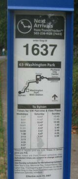
TransitTracker™ provides real-time bus and MAX arrivals online over the phone. The system tracks the actual location of your bus or train, so you know exactly when your ride is coming. Each stop has an unique "stop number" displayed on a sign like the photo above.
Get arrival times over the phone: Just dial 503-238-RIDE (7433) from any touch-tone phone. If you're using a web-enabled cell phone, you can access TransitTracker at wap.trimet.org. On a web-enabled PDA, log on to pda.trimet.org.
American Built Streetcars
Clackamas-based Oregon Iron Works, has been selected by Portland Streetcar Inc. for a $20 million contract to build seven new streetcars at about $3.3 million apiece. This is for the new Eastside/Lloyd Center/OMSI Extension. The company is now working on the finishing touches of its prototype streetcar, making it the only company in the U.S. building the “modern American streetcar.”
If Portland is mentioned in any out-of-state media, rest assured the news item is either about Portland's effort to contain urban sprawl or its public transportation system. Three public transportation modes are used by Portlanders: light rail, buses, and streetcars.
The City of Portland Office of Transportation is a community partner in shaping a livable city. Their Web site is pack with information about getting around Portland. TriMet, the regional governing body, operates the light rail system, the WES (Westside Express Service) commuter train, and the bus routes. The Portland Streetcar is owned by the City of Portland and a private non-profit runs the streetcar system.
Below are three maps to help you navigate the public transportation system.
System Map Light rail, WES commuter train, streetcar, and bus routes.
Rail Map Light rail, Westside commuter, and streetcar.
PDX Bus PDX Bus is brilliant and the only transit app you'll need to get around on public transportation in Portland. It displays MAX stops, bus stops, WES stops, and streetcars. Every TriMet bus stop and rail station as its own unique Stop ID number. Enter the Stop ID number and get the arrivals for that stop. It's free for the iPhone
Dadnab Dadnab uses as old-fashioned text message − just text your location and destination to 503-406-8622 to give it a try. And you don’t need to shell out $$ and a long term contract to get it.
Portland Transit Trip planner for Android. It allows you to look up arrival times for any stop that TriMet reports. This includes all MAX stops, bus stops, and WES stops (unfortunately Streetcar times are not currently available).
Pdxtrian Location and arrival app and its a free Android app. ArrivalTracker for the iPhone is its equal showing TriMet bus and train arrival predictions.
Transitly Unlike mapping and trip planning applications, Transitly for the iPhone does not offer maps, step by step instructions, or routing information. The logic is that most ride the same one or two buses or trains everyday, and don't need all these features. All they need to know is: "When is my next bus?" Transitly for the Android provides you with personal mass transit timetables on your Android device.
Transit Surfer Cell phone web browser interface for accessing real time arrival information for TriMet and Streetcar routes. It's named 'Surfer' for those of us who 'surf' the transit system, making real time judgments about what route or vehicle will get us to our destination most quickly. As such it's designed to put comparative information on the screen and let you quickly access related information. You can find Transit Surfer at http://tsrf.us.
Light Rail
On Labor Day weekend in 1986 the first MAX line opened and it covers 15 miles between Portland and Gresham. The line was later named the Blue Line when TriMet went to a color-coding system in 2001. When it was built, MAX was only the third modern light-rail system in the country. Since then, light-rail has sprung up in over 20 cities in the nation.
How did light rail come to happen in Portland? It goes back to the fight over the Mt. Hood Freeway, which would have branched off Interstate 5 at the Marquam Bridge and run east toward Gresham. The plan was to push it through Southeast Portland, along a route that would have required bulldozing many of the neighborhoods between Division Street and Powell Boulevard. Among other things, that freeway would have paved over the areas such as Seven Corners, the Clinton Business District and hundreds of old homes in the area. In 1974, after the neighborhood revolved, the freeway plan was scrapped and federal freeway funds were aimed instead toward light rail and other transportation improvements.
The light rail system is now 52 miles and growing. Currently under construction is the Milwaukie-to-Portland line due for completion in 2015. It will add another 7.3 miles of track to the system.
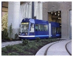
Portland's light rail network (MAX) is operated by the Tri-County Metropolitan Transportation District of Oregon (TriMet). It is charged with devising a suitable light rail network to attract new development without bringing a disproportionate growth in road traffic.
The 52-mile light rail network carries over 35 million riders a year and TriMet's bus service lines had 64 million boarders.
Eastside MAX Blue Line The first phase, Eastside MAX (Metropolitan Area Express), connected Gresham, Oregon state's fourth largest city, with downtown Portland, and was constructed between 1982-86. Between 1990-97 TriMet ridership grew 40 per cent faster than its population growth. During the same period, TriMet ridership grew 30 per cent.
Westside MAX Blue Line The Westside MAX, Hillsboro to Portland light rail system began service in September 1998. Construction began on the 18-mile light rail line in May 1994. The Westside line has 20 stations, nine park and ride interchanges and has spawned numerous other developments. The 33-mile run from Gresham to Hillsboro takes 93 minutes.
Airport MAX Red Line This was a $125 million, 5.5-mile extension developed through an innovative public/private venture involving the Port of Portland, TriMet, the City of Portland, Portland Development Commission and Bechtel Enterprises. Bechtel contributed $28.2 million towards the $125 million project. It links Portland International Airport to the existing regional light rail system. The system was completed in late 2001.
Interstate MAX Yellow Line A 5.8-mile segment opened May 1, 2004. This $380 million line connects MAX to the Expo Center along North Interstate Avenue. It is a unique opportunity to revitalize businesses and neighborhoods along North Interstate Avenue, once Portland's main gateway.
South Corridor Green Line The $575.7 million (6.5 miles) expansion of light rail to Clackamas Town Center along Interstate 205 and on to the downtown transit mall to Portland State University opened in September 2009. The Federal government picked up 60 percent of the project or about $345 million. The Green Line connects 19 bus lines, five park-and-ride lots (2,300 spaces) and one of the largest regional malls, The Clackamas Town Center. It also connect to the Red Line for access to the airport.
The project transformed Portland's old and aging transit mall into an inviting place for residents, commuters and shoppers. The Green Line runs the length of the Mall, connecting Union Station and Portland State University. A number of improvements, including refurbished streets and sidewalks, new transit shelters, better lighting and eye-catching public art, were part of the project.
Plans for Future Light Rail Routes: Milwaukie Extension
South Corridor Extension to Milwaukie Regional leaders see the line to Milwaukie as the fulfillment of a 20-year promise to connect the southeast metro area to downtown with mass transit. Metro expects daily rider numbers for the route to top 14,000 per day, as 50,000 residents will live within walking distance of the light-rail line.
In July, 2008, Metro unanimously approved the locally preferred alternative for the Portland-Milwaukie light-rail project, which will run between Southwest Fourth and Southwest Fifth Avenues near Portland State University, cross the Willamette River on a new transit bridge near Oregon Health and Science University, and follow the Tillamook Railroad into Milwaukie.
The 7.4 mile light-rail line will serve up to 11 stops, nine of which will be within Portland's city limits. A bridge (see below image) for the proposed $1.4 billion light-rail line to Milwaukie, would carry everything but cars and trucks.
The Portland-Milwaukie Light Rail is slated to open in September 2015. Construction on the project’s light-rail bridge begin in mid 2011. This early construction work is allowed to take advantage of the relatively small “fish window,” where in-water work can be done with limited impact to migrating fish. The project is expected to move into full construction in mid 2012, after TriMet signs a Full Funding Agreement with the federal government. The federal government may commit to funding 50 percent of the project.
Follow the progress of the line at the Trimet Web site. The Portland-Milwaukie Light Rail Project has two cameras providing live footage of the construction of the light rail bridge--construction begins July 1, 2011. On the west side of the Willamette River, a camera is positioned on the Oregon Health & Science University (OHSU) Center for Health and Healing in South Waterfront. On the east side, a camera is on the Oregon Museum of Science and Industry (OMSI). Note: To view the camera footage, your browser's pop-up blocker must be turned off and your viewing device must have a current version of Adobe Flash.
Vancouver to Portland The Portland area has another plan for light-rail. The proposed $4.2 billion I-5 replacement bridge, would carry a light-rail extension north to Vancouver. Planners expect that the light-rail would help ease the traffic bottleneck on the bridge.
Other Plans Planners envision a route to Sherwood and Tigard, and another along Southeast Powell Boulevard.
Portland Streetcars
Streetcars are back in Portland! They left in the 50s and started again on July 20, 2001. Streetcars run on a 4.8 continuous loop from Legacy Good Samaritan Hospital at NW 23rd Avenue, on Lovejoy and Northrup, through the Pearl District and on 10th and 11th Avenues to a SW 5th and Montgomery Terminus at Portland State University. Another extension (about 2 miles) goes south of downtown along the river to RiverPlace and South Waterfront.
The Portland Streetcar is owned by the City of Portland. A private non-profit runs the streetcar system. Unlike, the bus system or light rail, which is operated by TriMet, a public agency, the streetcar is run by Portland Streetcar Inc.
Streetcar vehicles, manufactured by Skoda-Inekon in Plzen of the Czech Republic, are 2.46 meters (about 8 feet) wide and 20 meters long (about 66 feet), about 10 inches narrower and 1/3 the length of a MAX (TriMet’s light rail system) double car train. They run in mixed traffic and, except platform stops, accommodate existing curbside parking and loading. View photos and detailed specs of the Skoda cars. The Eastside extension will use streetcars manufactured by an Oregon company (United Streetcar).
RiverPlace Extension The Portland Streetcar extended the line .6 tenths of a mile to RiverPlace (south of downtown along the river). Construction of this extension started in the Winter of 2003 and opened March 12, 2005.
Gibbs Extension to South Waterfront This extension was completed to SW Gibbs in late 2006. This 0.6 mile extension connects at SW River Parkway and SW Moody, follows SW Moody south to SW Sheridan and from SW Sheridan to SW Gibbs utilizing the former Willamette Shore trolley rail right-of-way. The stop is located at SW Moody and Gibbs at the base of the Portland Aerial Tram. The cost of this extension was $15.8 million, which includes purchase of three additional streetcars. Extending the line to SW Gibbs was a high priority for the newly emerging South Waterfront “River Blocks” development and the Oregon Health and Science University’s Building One, a 16-story building, that contains outpatient practices, educational offices, and research laboratories.
Lowell Extension to South Waterfront The Portland Streetcar started construction on the Lowell Extension in August of 2006 and it was completed in the summer of 2007. This 0.6 mile extension connects at SW Moody and Gibbs (base of Portland Aerial Tram), follows SW Moody south to SW Lowell, east on SW Lowell to SW Bond. The route continues north on SW Bond to SW Moody & Gibbs.
Eastside/Lloyd Center/OMSI Extension The $148.27 million extension to the eastside, which broke ground in August 2009, will extend the existing Portland Streetcar System from the Pearl District across the Broadway Bridge into the Lloyd Center neighborhood and then south to the Oregon Museum of Science and Industry. The loop is set to open to the public in late 2012. The expansion means jobs − not only for construction to expand the streetcar system by three plus miles and 18 stations, but also for manufacturing the streetcars, which will be built by United Streetcar, a subsidiary of Oregon Iron Works, in Clackamas, Oregon.
Eventually the line will "close the loop" and connect the east side of the river to the existing system on the west side of the river by using the same transit bridge that the light rail line to Milwaukie uses. It will connect the Lloyd Center to downtown. View a map of the proposed line. For construction updates on the line, click here.
Lake Oswego Extension Metro is beginning a corridor study to evaluate possible transit and transportation options between Lake Oswego and Portland. The cities of Portland and Lake Oswego, Clackamas and Multnomah counties, the Oregon Department of Transportation and TriMet are participating in the study. Citizens, business representatives and property owners have been selected to serve on a Project Advisory Committee that will meet monthly to consider issues and alternatives.
A streetcar connecting Portland and Lake Oswego could cost $379.6 million to $458.3 million to construct and another $1.25 million annually in today's dollars to operate, according to a draft environmental impact statement recently released by Metro in early December, 2010. An alternate option, enhanced bus service, would cost roughly $51.1 million, plus $2.79 million annually to operate. In both cases, federal funds could possibly cover 60 percent of the cost, with the rest coming from local sources.
In the days before automobiles and smooth roads, streetcars were the primary way around most American cities. Portland's first public-transit system, a horse-drawn trolley along the old First Street, opened in 1872. In 1906, the Portland Railway Light and Power Company operated 40 lines over 172 miles of track. At one time Portland had the third largest streetcar system of its kind in the United States. Its cable car line was steeper than anything in San Francisco. Most of the streetcar companies were privately-run operations that were also involved in real estate and electrical power. Some even built amusement parks, known as "Trolley Parks," to attract riders on weekends and off hours. Oaks Park in the Sellwood neighborhood remains one of the nation's last trolley parks.
Of course, the system we're building now is nothing like the ones that once covered city maps and crowded our streets. The old tracks weren't as durable or expensive. By the end of 2011 when the eastside extension is completed, we will have just 7.3 miles of streetcar track.
Planners credit the westside streetcar with spurring $3.5 billion in investment, and note that more than half of all the development in downtown since 1997 fell within a block of the new line. Word must have gotten out because about 25 cities are building their own new lines.
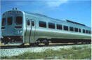
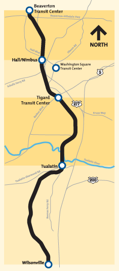
Westside Express Service Commuter Rail
TriMet showed off its new commuter train on January 21, 2009 at a "first ride" for Westside community leaders, the first public passengers on its route between Beaverton and Wilsonville.
The Westside Express Service (WES) started as a proposal to ease congestion along the Interstate 5 corridor. After 14 years of planning and troubles with its manufacturers, trains will run about every 30 minutes Monday through Friday during morning and evening rush hours.
Transit officials estimate that WES will have 2,400 riders a day. They expect it to reach 4,600 by 2020. Three self-propelled cars and one trailer will complete 32 round trips a day. Each car has about 80 seats, along with standing room and space for bicycles and wheelchairs. In addition, WES will have free Wi-Fi onboard and interactive public art at each of its five stops. Parking for cars and bicycles will be available at most of the stops.
Residents along the 14.7-mile rail line from Wilsonville to Beaverton now have the option to avoid the congested I-5 and Highway 217 corridors. You are able to ride commuter trains from Wilsonville, Tualatin, Tigard and Washington Square to the Beaverton Transit Center, where you can transfer to the MAX light-rail for the remainder of your trip to the Portland City Center.
The first phase of construction—track rehabilitation—began in Wilsonville in late October 2006 and moved north to finish in Beaverton in January 2009. In early March 2007, ground was broken on the first of five commuter rail stations to be built for the Washington County Commuter Rail line. Formerly part of the Oregon Electric Railway, this line is now being operated for freight service by a short-line railroad, the Portland & Western. Unlike the MAX light-rail — which also follows freight rail lines for part of its route, but has separate tracks — the commuter rail service to Wilsonville operates on the very same tracks used for freight service.
The estimated cost of the project was $120 million. Some of this was covered by local and state funding and TriMet obtained some federal funds to cover the rest of the projected cost.
The WES line operates by diesel-powered equipment. Unlike other transit agencies, which use diesel engines to pull non-powered commuter coaches, TriMet purchased self-propelled Diesel Multiple Unit (DMU) equipment for this new line. This means that one unit, or vehicle, is able to drive by itself without being pushed/pulled by a locomotive. A typical DMU has several small diesel engines with automatic transmissions. Each bi-directional vehicle has a driver cab on each end, which allows a fast change of direction without driving through a long loop to turn the vehicle around. The driver simply walks from one end to the other. Several DMUs can easily and quickly be coupled together to make a longer train if a higher passenger capacity is needed, for example during the morning or afternoon peak hours or during special events. No additional train operator or other personnel is needed.
Free Rail Zone (aka Fareless Square)
Free Rail Zone provides free rail rides (light rail and streetcars) in the downtown Portland area bounded by the Willamette River, Northwest Irving, and the I-405 freeway. In 2001, the fareless zone was extended across the river to the Lloyd District − Multnomah Boulevard on the north, Holladay Street on the south and 14th Street on the east.
The fareless policy started in 1975 as a way to cut pollution and endured as a symbol of the region's commitment to bus and light-rail use. Free bus rides were included in the early free zone but as of January, 2010, the TriMet transit agency required that thousands of bus riders pay their full fare in downtown Portland's Free Rail Zone. MAX light-rail lines and the Portland Streetcar will remain free within the fareless zone.
Though 45,000 people board buses each weekday within the fareless area, only 14,000 remain within the square, and fewer are without prepaid bus passes, according to TriMet estimates. As a result, TriMet officials expected the impact would be offset by expanded free rail service. The MAX Yellow Line is redirected to serve the downtown transit mall and the new MAX Green Line start in September, 2009 − giving most fareless bus riders a train alternative.
The free zone was called "Fareless Square" when it started in 1975. The name was changed to "Free Rail Zone" in January, 2010.
High-Speed Rail from Eugene to Vancouver
A portion of a $9.3 billion provision in the federal stimulus bill (March 2009) could beef up passenger train service between Eugene, Oregon and Vancouver, B.C. The bill includes $1.3 billion for Amtrak for capital projects and $8 billion for states to foster high-speed passenger rail. The federal money doesn’t begin to cover the cost to modernize the U.S. rail system enough to carry true “bullet” trains that travel at 200 miles per hour and up.
Ten regions, including the 400-mile stretch of track between Eugene and Vancouver, B.C., were identified for high-speed rail more than a decade ago. It’s too soon to know if the Northwest corridor will receive stimulus money for rail improvements. In Oregon, the Department of Transportation is preparing its pitch to the Federal Railroad Administration.
In Oregon, as in Washington, passenger trains run on privately owned track — Union Pacific in Oregon and Burlington Northern Santa Fe in Washington. High-speed rail does not benefit freight trains, which are limited by size and weight to 79 miles per hour. Passenger trains also travel top out at 79 miles per hour.
If Oregon and Washington succeed in winning federal dollars, the plan eventually is to boost Amtrak speeds to 110 miles per hour. That’s well below the 200-mph “bullet” speed that are used across Europe and Japan. Trains also can’t travel more than 110 miles per hour without significant track improvements. Trains traveling faster than that must be kept separate from trucks and cars. That means streets and highways need to go over or under tracks, not across. It costs $4 million to $30 million to separate a crossing. With about 700 crossings between Portland and Eugene, the cost in Oregon would be $2.8 billion at a minimum.
Source: Oregon seeks federal cash for high-speed rail route - March 13, 2009. Portland Business Journal.
History of Rails in the Willamette Valley
Our modern light-rail and streetcar system is a continuation of a long history of using “rails” for mass transit in the Portland metro area. The entire Willamette Valley had a long history of using rail systems for transportation. It was interrupted by 36 years of "bus only" public transportation from 1950 until the Eastside Max Blue Line (light-rail) opened in 1986.
In 1872, just 21 years after Portland was officially founded, the city’s growth prompts the need for a public transportation system. Portland's first trolleys, brought by steamer from San Francisco by Ben Holladay, were horse and mule drawn, operating on First Avenue from Glisan to Caruthers. In 1888, steam-operated streetcar lines began service, developing into a network that served Hawthorne, Mt. Scott, Mt. Tabor, St. Johns, west Portland, and Vancouver, Washington.
By 1889, electric streetcars began service, gradually replacing horse-drawn, cable and steam-powered lines. Installed by land developers to promote new subdivisions, a network eventually extended out to city limits in all directions. By 1910, interurban railway service extended from Vancouver south to Eugene and Corvallis, and from Gresham and Troutdale west to Forest Grove and McMinnville. Meanwhile, the “Good Roads” movement gained momentum, and Oregon embraced the automobile—becoming the first state to pay for roads with a gas tax.
In the 1920s, trolley transportation growth slowed. Cutbacks in service and labor economies, such as remodeling equipment for one-man car operation, became the norm. The Great Depression saw further erosion of what was once one of the most advance rail systems in the West. Buses and trolley coaches began to replace electric streetcars. Several interurban rail lines discontinued passenger service as ridership declines and the aging streetcar system began converting to buses and trolleybuses. WWII saw a resurgence of the use of the rail system due to gas rationing and limited availability of cars. But it was short lived and by 1950, the last streetcars were retired. Automobiles became the main source of transportation and leaders had to deal with a new problem: congestion on the roads.
What caused the demise of streetcar systems in the country? According to an 2007 article in the International Herald Tribune, "In the 1920s, there were about 1,200 electric lines operating across the United States providing some 15 billion rides a year. By the 1970s, the number of American cities with real streetcar systems was down to about five." The article went on to say that, "Reasons for the demise vary but include National City Lines, formed by General Motors, Standard Oil of California, Phillips Petroleum and Firestone tires. It bought up more than 100 lines in the 1930s and 1940s in many of the larger cities and dismantled them."
American Company to Start Building Streetcars Clackamas-based Oregon Iron Works, has been selected by Portland Streetcar Inc. for a $20 million contract to build seven new streetcars at about $3.3 million apiece. The company is now working on the finishing touches of its prototype streetcar, making it the only company in the U.S. building the “modern American streetcar.” The push for urban transit systems could prove to be a boon for Oregon Iron Works, which is also a finalist for a job to produce another seven streetcars for the city of Tucson, Ariz., in a project that is also vying for the federal New Starts money.
Buses
The Portland metropolitan area has an extensive bus lines with over 650 buses. Here are the links to the fleets to include photos of some of TriMet's buses and a link to the bus routes maps and schedules.
Car Sharing: Zipcar
Zipcar is a car-sharing system where you share access to hundreds of Zipcar vehicles. You reserve a car online or by phone; you drive - to a meeting, to run errands, or to hit the lumber yard; and you return to the car's designated parking space, all for one hourly rate that covers gas and insurance. All you pay for is the drive. The Portland Zipcar system has 240 vehicles.
Bicycles
Also available to lower commuting costs is an extensive bicycle path system. Plus TriMet is now 100% bicycle friendly! All MAX and buses can accommodate bicycles. Check out the bike links.
The average daily trips across Portland's four busiest cycling bridges have increased after a one-year decline according to a report released in November 2010. There are now roughly 17,500 bicyclists per day crossing the Willamette River via four bike-friendly bridges the − Hawthorne, Steel, Burnside and Broadway − according to the study. Bike traffic on the four bridges increased 12 percent. Cyclists represented about 14 percent of all vehicles crossing those bridges, a one percent increase compared to 2009. On the Hawthorne, 20 percent of all vehicles crossing were bikes, a one percent decrease compared to 2009. On the Broadway the number of bikers was 16 percent; on the Steel, 17 percent; and on the Burnside, 5 percent.
American Automobile Association chapter Oregon/Idaho is the first AAA club in the U.S. to include bicycle service as part of its regular roadside membership benefits package for AAA Plus, Plus RV and Premier members. There is no additional charge for roadside service which applies to all bicycles and tandems, including rental bicycles and bicycle trailers.
The City of Portland has extensive bike maps and resources at there Web site. You can also use byCycle bicycle trip planner, a free online tool to help both new and seasoned cyclists plan safe trips through the city. This private Web site was created by cycling enthusiasts volunteering their time, with support from Metro.
Rent a Bike
Renting a bike for a short trip are widely used in Europe but are new to North America. Paris supports one of the world's largest systems, with 21,000 bikes, 170,000 annual subscribers and kiosks throughout the city. Cities across the nation, including Portland, are investigating whether they would work on their streets. Finding the money is the problem. Washington, D.C., already has a small program − about 100 bikes − the first in the United States. The programs typically are expensive, averaging $3,400 to $4,000 per bike when figuring in the cost of docking stations, tracking and payment technology and installation.
Portland Bicycle Tours, a 3-year-old rental business, began offering subscriptions in 2008. They have 40 recycled bikes locked in high-traffic areas and at a garage in Old Town/Chinatown. They charged members $20 to $40 per month. When members need a bike, the system sends them the lock combinations by text message.
For information about bike sharing in Portland, visit the City of Portland's Office of Transportation.
Video on Biking in Portland
Here's a video of biking in Portland produced by the New York Times. It's a good history of biking in the Rose City.


 On Labor Day weekend in 1986 the first MAX line opened and it covers 15 miles between Portland and Gresham. The line was later named the Blue Line when TriMet went to a color-coding system in 2001. When it was built, MAX was only the third modern light-rail system in the country. Since then, light-rail has sprung up in over 20 cities in the nation.
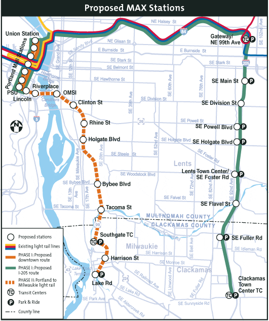
 The WES line operates by diesel-powered equipment. Unlike other transit agencies, which use diesel engines to pull non-powered commuter coaches, TriMet purchased self-propelled Diesel Multiple Unit (DMU) equipment for this new line. This means that one unit, or vehicle, is able to drive by itself without being pushed/pulled by a locomotive. A typical DMU has several small diesel engines with automatic transmissions. Each bi-directional vehicle has a driver cab on each end, which allows a fast change of direction without driving through a long loop to turn the vehicle around. The driver simply walks from one end to the other. Several DMUs can easily and quickly be coupled together to make a longer train if a higher passenger capacity is needed, for example during the morning or afternoon peak hours or during special events. No additional train operator or other personnel is needed.
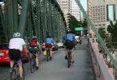 Also available to lower commuting costs is an extensive bicycle path system. Plus TriMet is now 100% bicycle friendly! All MAX and buses can accommodate bicycles. Check out the