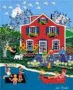
Mount Tabor, named for the 600-foot high extinct volcano that is its landmark, has a sweeping city and mountain views, proximity to downtown, a scenic 195-acre public park, and an easy mix of modest older homes and stately mansions. Mt. Tabor is the only volcano within a major city in the United States.
Hawthorne Boulevard, the street full of shops and restaurants, ends at the base of Mount Tabor Park and it's one of the most used parks in the city. As you enter the park you will immediately notice reservoirs. They hold a large portion of Portland's drinking water, piped straight from the Bull Run Reservoir in the Cascades. The park has trails, bike paths, and stands of old growth Douglas Firs and other trees. Catch a summer sun setting on downtown and the West Hills from the park.
Mount Tabor is a very stable neighborhood, and people stay in Mount Tabor once they relocate to the area. Homes come in a variety of styles and shapes so people can usually find what they are looking for in a home.
History of Mount Tabor
The neighborhood has a long history that goes back almost as far as Portland itself. The Reverend Clinton Kelly settled on the east side of the river in 1848, and though his claim was west and south of Mount Tabor, his family figured prominently in the later history of the area. After purchasing claim rights for $50 he settled and began to farm while continuing circuit riding and preaching.
Reverend Kelly’s circuit riding duties took him throughout the lower Willamette Valley. He came into contact with Dr. Perry Prettyman, a fellow Methodist who had come to Oregon with his family from the east. After nearly two years in Oregon City, Prettyman and wife, Elizabeth, and family moved to Mount Tabor and staked out their claim. Probably a naturopath rather than an M.D., he had studied medicine at the Botanic Medical School in Baltimore. We have Prettyman to thank for that nemesis of the green lawn—the dandelion—for it was he who introduced that plant to the Northwest, having brought it here from Missouri for medicinal purposes. Prettyman practiced medicine up until his death in 1872.
The settlers in the Mount Tabor area were farmers, primarily engaged in fruit growing, and the area grew most of the fruit shipped from Portland to California. The gold rush in California created a demand for fruit and afforded huge profits to those who supplied it.
Some dates:
1846: The year of the "Big Burn" which destroyed the forests on the eastside.
1862: James B. Stephens donates land on U Street (now called Hawthorne) between Ninth and 12th avenues to J.C. Hawthorne for the Oregon Hospital for the Insane. U street becomes Asylum Avenue.
1870s: Railroads are introduced, fueling further settlement and expansion on the east side.
1883: The hospital closes and the land becomes a park. It takes another five years before Asylum Avenue is renamed, and takes the Hawthorne name.
1887: Morrison Bridge is completed, launching an East Portland building boom. A year later, the streetcar runs from downtown along Hawthorne and eventually south on SE 50th to Lents.
Origin of the Name Mount Tabor
Portland's Mount Tabor was named after another Mount Tabor, which sits six miles east of Nazareth in Israel. Our Mount Tabor makes Portland one of only two cities in the continental U.S. to have an extinct volcano within its boundaries; the other city is Bend, Oregon. It was a contest between Mount Tabor and Mount Zion.
Mount Tabor Home Styles
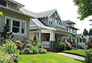
Mount Tabor is a neighborhood of detached single-family homes. This is an older neighborhood so most homes were built in the 1900s. You will see Arts and Crafts, Bungalows, Colonials, English Cottages, Tudors and a hand-full of modern styles.
An informative brochure about some of the architectural home styles found in the Mount Tabor neighborhood can be downloaded by clicking here. Included are addresses of Mount Tabor homes built in each architectural style.
1Mount Tabor Home Prices
Number of homes sold in Mount Tabor in 2010: 111. Distressed properties sales were 6%.
Median price for homes sold in Mount Tabor: $355,000 in 2010; $359,000 in 2009; $374,850 in 2008; $399,500 in 2007.
1-year median sales price change in 2010 from 2009 in Mount Tabor: -1%.
5-year median sales price change in Mount Tabor: -4%.
Metro area median home prices: $239,900 in 2010; $247,000 in 2009; $278,000 in 2008; $290,000 in 2007.
Metro area average home prices: $282,100 in 2010; $289,900 in 2009; $330,300 in 2008; $342,000 in 2007.
Please be aware that the above figures are subject to error and are intended as guidelines only. To view Mount Tabor homes currently for sale click here.
Parks in Mount Tabor
The 195-acre Mt. Tabor Park is one of Portland premier parks. The park includes basketball court, play area, a restroom, picnic area, dog off-leash area, picnic tables, playground, and tennis courts. This park is made for walking as it has miles of trails.
At the top of the park is a bronze statue of Harvey W. Scott, editor of The Oregonian newspaper from 1865-1872 and from 1877 until his death in 1910. A gift to the city by Scott's widow, Margaret, and family, it was sculpted by Gutzon Borglum in the early 1930s while at work on his monumental sculpture of four American presidents on Mt. Rushmore in the black hills of South Dakota.
In 2000, the city renovated park structures, roads and bathrooms. But the sprawling park had plenty of trails and places that offered spots where people could drink, use drugs or cause other problems. Parks officials began working with the Mount Tabor Neighborhood Association for ideas to make the park inviting and safe. From those meetings, the nonprofit Friends of Mount Tabor Park began. The group collects dues and sells T-shirts to raise money for park projects. Over the years, the group has paid for such things as bike racks, timber to replace rotted steps and a water supply in the picnic area. The patrol with 40 active members celebrated its 10th anniversary in 2010. The group has logged more than 2,700 patrols and donated more than 18,000 hours.
Take It Outside Fitness, a class taught by Kristin Jackson, a licensed personal trainer and lifestyle coach who lives in Southeast Portland has one of his classes meets at Mount Tabor Park twice a week, rain or shine, for an hour of cardiovascular exercise, strength training and stretching.
Mount Tabor has 184 acres of park land and open spaces according to Metro and the Portland Department of Parks and Recreation.
Mount Tabor Historic Reservoirs
Mount Tabor has three reservoirs, all of which were accepted to the National Register of Historic Places in January 2004. The reservoirs are located in the Mount Tabor Park. Its elevation and central location relative to the city of Portland made this an ideal place for the city to house a water supply from the Bull Run reservoir in the Cascade Mountains.
The reservoirs were built during the period of 1894 and 1911, along with two reservoirs in Washington Park. The reservoirs and their gatehouses are artistically constructed, incorporating extensive stonework and wrought-iron. There were initially four above-ground reservoirs, numbered 1, 2, 5, and 6. Reservoirs 3 and 4 are at Washington Park, and Reservoir 7 is a small underground reservoir near Mount Tabor's summit. Reservoir 2, on the corner of SE 60th and Division, was decommissioned in the 1980s, and the property was sold to a private developer. Its gatehouse remains, and is used as a private residence. Reservoir 6 is the largest, with two 37 million gallon chambers; it also contains a fountain, which was unused for many years, however it was reactivated in early 2007.
These reservoirs are not filtered. This came to light on June 30th, 2008, when a local TV station reported two people were caught skinny dipping in one of the offline reservoirs the night of June 29th. Reservoir officials say its fortunate this particular reservoir was offline at the time, because draining and refilling it would have cost tens of thousands of dollars. However, it should be realized that birds, insects and wildlife contaminate the open-air unfiltered reservoir on a daily basis. After 9-11, the federal government mandated that all open water supplies be covered. This would would cost the city millions and citizens have organized and fought the covering of the reservoir both at Mount Tabor and Washington Park.
The Mount Tabor neighborhood Web site has detailed information about the reservoirs and their struggle to stay uncovered. Here is the link to the source.
Hawthorne Business District
Ask any Portlander where 'Hawthorne' is located and they will know. Hawthorne is not a "neighborhood" as such, but five neighborhoods converge on the area for shopping and dining. The Hawthorne Business District is about 20 blocks long starting at 30th Avenue and ending just a few blocks from the neighborhood's west boundary. Most of the establishments are small shops and locally owned except for the Fred Meyer superstore. It is one of the city's more interesting shopping areas.
Explore the paths and historical features of Mount Tabor Park, home to reservoirs and a remnant volcanic cinder cone. The 2.1-mile walk combines stairs, closed roadways and unimproved paths as you climb and descent the summit. The payoff is the views. Click here to download the guide.
Another walk in Mount Tabor Park is the tree walk in which you identify over 30 trees. Click here to download the guide.
Walk Score ranks 2,508 neighborhoods in the largest 40 U.S. cities to help you find a walkable place to live. Mount Tabor is the #27 most walkable neighborhood in Portland. This neighborhood is 'Somewhat Walkable' with an average Walk Score of 69. Below is a Walk Score for an address in the center of the Mount Tabor neighborhood.
More About Mount Tabor
Neighborhood Association Web SiteMount Tabor Neighborhood Web site. The Mount Tabor neighborhood has a terrific Web site that is full of history and information about the community.
Location From downtown cross over the Willamette River on the Burnside Bridge. Drive out on East Burnside and when you get to SE 50th Avenue, the neighborhood will be on your right side.
Topography Flat to hilly on east end of neighborhood. Mature trees on properties. Parks are wooded.
Sidewalks and Streets The street pattern is grid with sidewalks for walking.
Livability Study 93.1% of Mount Tabor residents rated their neighborhood "good" or "very good." See Livability Study. The entire survey and response is available at the Mount Tabor neighborhood Web site.
Public Transportation Bus routes 4, 15, and 20 run east/west and deliver passengers downtown. route 71 runs north/south. see schedule and routes at the TriMet Web site. Mount Tabor does not have a MAX light rail line or a streetcar line. Transit Score provides a 0-100 rating indicating how well an address is served by public transportation. Ratings range from "Rider's Paradises" to areas with limited or no nearby public transportation.
2Drive Time to Downtown 12-13 minutes.
3Demographics Population: 10,037. Area: 1,022 acres. Average population density: 9 persons per acre. Number of households: 4,705. Median household income is $49,447. Percent of home owners: 65. Percent of renters: 35. Diversity: 13.4% non-Caucasian.
4Crime Stats 2010 16 violent crimes. Total crimes per 1,000 people was 33. For the latest crime statistics for the Mount Tabor neighborhood, click here.
Sex Offenders Click here for the State of Oregon Sex Offender Inquiry System. After agreeing to the "Conditions of Use Statement" you will be redirected to a "Enter Search Criteria" page. Insert a zip code in the "Zip" field and click on the "Query" button. Mount Tabor zip code: 97215.
5Shopping and Services Number of supermarkets: 0. Mount Tabor is all residential but surrounded on all sides by neighborhoods that have commercial centers. The main business activity is just west of the neighborhood around SE 39th Avenue and SE Hawthorne in the Sunnyside neighborhood. You will find a Fred Meyer supermarket, bookstore, deli, boutiques, a movie theatre, and a few restaurants. New Seasons Market, a local chain, revamped a building located at SE 41st and Hawthorne vacated by a natural food store and it opened in late 2009.
Eating Out Just blocks (walking distance for the west end residents) to the west are two well-regarded restaurants: Three Doors Down at 1429 SE 37th Avenue and Bread and Ink at 3610 SE Hawthorne. Close by is Cup & Saucer and Chez Machin (the main attraction is the crêpes). Bridgeport Brewing at 3632 SE Hawthorne is the place for a cold one and a good burger. Also in the neighborhood are pizza shops, BBQ, and a fish sandwich eatery. See Willamette Week for reviews of these restaurants.
Public Library The neighborhood does not have a public library but two libraries are about the same distance from the center of the neighborhood. The Belmont Library at 1038 S.E. 39th Avenue and the Woodstock Library at 6008 S.E. 49th Avenue.
Who Lives in Mount Tabor White collar singles and young married couples. Because of the range of home prices, you will get affluent couples. They tend their lawn and gardens, walk in the park, and stroll along Hawthorne Boulevard. The median age of a resident is 38.
Cars in the Neighborhood Loads of smaller Japanese cars with a few pickups and SUVs. You'll see a luxury car at some of Mount Tabor's more elegant homes. One of the Webmaster's basketball playing buddies, who lives in Mount Tabor, drives a Volvo.
6Biking Quality ranges from high to fair. Mount Tabor has four miles of bike lanes. Bicycle Trip Planner will map a route for you and − just provide a starting point address and your destination address.
1Real Estate Values Data on real estate values provided by RMLStm. Distressed properties refer to the percentage of total homes sold that were short sales and bank-owned properties.
2Drive Time to Downtown Estimated commuting time obtained from Yahoo Maps and Google Maps. Drive time was calculated from a central intersection in each neighborhood to Pioneer Courthouse Square during the morning peak commute time.
3Demographics Data Numbers were obtained from Census 2000 and www.portlandmaps.com.
4Crime Statistics Numbers on crime represent total crimes for 2010 and were obtained from Portland Police Bureau. Violent crimes are defined as murder, rape, robbery, and aggravated assault. Crimes per 1,000 are based on reported incidents of violent crime, as well as burglary, larceny, and motor vehicle theft.
5Shopping and Services Numbers were determined from local directory listings and county/municipal library systems.
6Biking Quality rating based on the 2007 Cycle Zone Analysis conducted by the City of Portland Office of Transportation. The six-tier ratings have been reduced to three levels: High, Fair, and Low.
7School Report Card Grades Schools ratings from the Oregon Department of Education 2009-2010 performance assessment. "O" = Outstanding; "S" = Satisfactory; "I" = In Need of Improvement; NR = Not Rated.
North - East Burnside.
South - SW Division Street.
East - SE 76th Avenue.
West - SE 49th Avenue (from Burnside to Hawthorne)
and SE 50th Avenue (from Hawthorne to Division).
To learn more about the
Mount Tabor neighborhood
visit Portland Maps.
It will provide you with a list of businesses, demographic data,
crime stats, parks, schools, aerial photos, maps,
elevation, etc.
All you need is a property address − use
"5921 SE Hawthorne Blvd."


 Mount Tabor, named for the 600-foot high extinct volcano that is its landmark, has a sweeping city and mountain views, proximity to downtown, a scenic 195-acre public park, and an easy mix of modest older homes and stately mansions. Mt. Tabor is the only volcano within a major city in the United States.
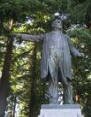 The 195-acre
 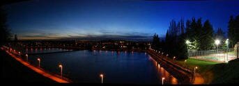 Mount Tabor has three reservoirs, all of which were accepted to the National Register of Historic Places in January 2004. The reservoirs are located in the Mount Tabor Park. Its elevation and central location relative to the city of Portland made this an ideal place for the city to house a water supply from the Bull Run reservoir in the Cascade Mountains.