|
|
|
Portland Planning and Zoning
|
|
Planning History
 Perhaps no city in the United States is cited as often as Portland, Oregon in the urban planning literature for its progressive transportation and land use policies, downtown redevelopment efforts, and purported success in containing urban sprawl. The most significant part of this effort is the rings (Urban Growth Boundary or UGBs) around 257 of Oregon's municipalities that define where town stops and forest and farm fields begins. UGBs were first proposed by Governor Tom McCall, a Republican, in 1973 as a way to preserve farms and forests. Perhaps no city in the United States is cited as often as Portland, Oregon in the urban planning literature for its progressive transportation and land use policies, downtown redevelopment efforts, and purported success in containing urban sprawl. The most significant part of this effort is the rings (Urban Growth Boundary or UGBs) around 257 of Oregon's municipalities that define where town stops and forest and farm fields begins. UGBs were first proposed by Governor Tom McCall, a Republican, in 1973 as a way to preserve farms and forests.
The metro area faces many challenges in the next few years as the population is expected to double, to about 4 million, by 2060. Does that mean more Pearl like condominiums in Portland, neighborhoods sprung from farm fields, both? And if suburban communities want to expand, will that come at the expense of the region's core?
In 2009, for possible expansion, Washington County officials have identified twice as much land as Multnomah and Clackamas counties combined. The discourse has been diplomatic, but behind every pitch, there are dollar signs, old wounds and the anticipation of horse-trading. Anti-annexation sentiment has burned Beaverton and Tigard, keeping more than one-third of county residents in urban neighborhoods outside of cities. In contrast to communities on the west end, larger cities along Interstate 5 and Oregon 217 are mostly developed, leaving few places to grow. Complicating matters, Washington County has some of the state's highest-profile employers, and expansion for more industrial giants could eat away at highly valued agricultural lands.
Oregon Legislature Adopts Land-use Planning in 1973
Governor McCall and his allies convinced the Oregon Legislature in 1973 to adopt the nation's first set of land-use planning laws. McCall, with the help of a unique coalition of farmers and environmentalists, persuaded the legislature that the state's natural beauty and easy access to nature would be lost in a rising tide of urban sprawl. The new goals and guidelines required every city and county in Oregon to have a long-range plan addressing future growth that meets both local and statewide goals. In short, state land-use goals require:
Senate Bill 100 requires each city and county in Oregon to adopt and maintain comprehensive plans and land use regulations that meet state standards. The legislature delegated the authority to establish the state standards to the Oregon Land Conservation and Development Commission. This commission adopted standards called the Statewide Planning Goals. Several Oregon Administrative Rules, as well as regional policies and city policies supplement the Statewide Planning Goals.
Three Levels of Planning for the Portland Metro Area
-
State of Oregon
-
Regional Polices - Metro, the regional government that serves 1.5 million people who live in the 25 cities and three counties of the Portland metropolitan area
-
City of Portland Bureau of Planning, suburban cities planning departments, and county government
|
Groups Opposing UGBs
Oregonians in Action
A non-profit lobbying organization that leads the fight for land-use regulatory reform and protection for private property rights. They have put forth numerous voter initiatives. Funded primarily by developers and builders.
Home Builders Association of
Metropolitan Portland
The Home Builders Association have been among those critical of Metro for being too restrictive with setting the UGB.
Portland Metropolitan Association of Realtors
They donated $3,000 in the Spring 2002 election to support a measure that would have wiped out guidelines for density.
Cascade Policy Institute
A Portland group that advocates a free-market approach.
Thoreau Institute
Institute aim is to find small government means, including such techniques as user fees, markets, and incentives, to protect the environment. Located in Bandon, Oregon.
|
Groups Supporting UGBs
1,000 Friends of Oregon
Friends feels that the regulations work well. 1000 Friends of Oregon is a nonprofit charitable organization, founded in 1975 by Governor Tom McCall and Henry Richmond as the citizens' voice for land use planning that protects Oregon's quality of life from the effects of growth.
AFSCME Council
The public employees' union, the local Farm Bureaus, and many business and labor groups support the concept of UGBs.
Just about every major environmental and natural resources organization supports the efforts of Metro and the City of Portland to halt urban sprawl.
|
|
The Origins of Metro's Urban Growth Boundary
 The Columbia Region Association of Governments (CRAG), Metro's predecessor, engaged in a complete planning process and proposed an UGB for the Portland metro region in 1977. When Metro was created by voters in 1979, it inherited the boundary planning effort. A year later, the Land Conservation and Development Commission approved the boundary as consistent with statewide planning goals. The Columbia Region Association of Governments (CRAG), Metro's predecessor, engaged in a complete planning process and proposed an UGB for the Portland metro region in 1977. When Metro was created by voters in 1979, it inherited the boundary planning effort. A year later, the Land Conservation and Development Commission approved the boundary as consistent with statewide planning goals.
Metro is responsible for managing the Portland metropolitan region's UGB. The location of the Metro urban growth boundary involved more than simply drawing a line on a map. The plans and growth projections of Washington, Multnomah and Clackamas counties, along with 25 cities and more than 60 special service districts had to be accommodated. About 1.5 million people lived within the UGB.
In 1995, the Oregon Legislature adopted a law that required all urban growth boundaries, including Metro's, to provide sufficient buildable lands to accommodate housing needs for 20 years. It also required Metro to designate one-half of the 20-year buildable land supply for housing needs by the end of 1998 and any remaining housing need by the end of 1999. These urban zones are required to adjust their UGBs every five years to maintain a "twenty-year supply" of land that can be developed.
The urban growth boundary was not intended to be static. Since the late 1970s, the boundary has been moved about three dozen times. Today the urban growth boundary encompasses approximately The current urban growth boundary encompasses approximately 400 square miles (about 256,360 acres). Metro expanded the Portland-area boundary in 2002 by 18,867 acres, its largest expansion to date.
View a map of the urban boundaries in the Portland metro area.
Metro's Role
Metro is the directly elected regional government (the only regional government in the USA) that serves more than 1.3 million residents in Clackamas, Multnomah and Washington counties, and the 25 cities in the Portland, Oregon, metropolitan area. Metro provides transportation and land-use planning services and oversees regional garbage disposal and recycling waste reductions programs.
Metro manages regional parks and greenspaces and the Oregon Zoo. It also oversees operation of the Oregon Convention Center, Civic Stadium, the Portland Center for the Performing Arts, and the Expo Center.
|
|
2000 Census
These four tables on the Portland Metro area were released in mid-May 2002.
If you like numbers, you will find them engaging.
DP-1: Profile of General Demographic Characteristics 2000
DP-2: Profile of Selected Social Characteristics 2000
DP-3: Profile of Selected Economic Characteristics 2000
DP-4: Profile of Selected Housing Characteristics 2000
|
|
City of Portland Planning
In 1980, the Portland City Council adopted a comprehensive plan for the city, including goals, policies, objectives and a plan map, to guide the future development and redevelopment of the city. Portland's Comprehensive Plan Map reflects a 20-year vision of the city. Community and neighborhood planning efforts work to transition land uses from their current zoning designations to the Comprehensive Plan Map designations to reflect this 20-year vision as the city changes and grows. The Plan provides the City and its citizens with the following:
-
A set of land use and public facilities goals and policies to guide the development and redevelopment of Portland.
-
The Comprehensive Plan - Goal and Policies is the current adopted plan for the City of Portland. This plan guides the future growth and development of the city.
Visit the City of Portland's Bureau of Planning Web site for further details about planning in Portland.
|
|

Portland Planning History
Ernie Bonner, who served as Portland's planning director under Mayor Neil Goldschmidt in the 70s, created this Web site. It full of history and interesting interviews.
|
Metropolitan Housing Rule Mingles Income Groups
Bucking national trends, Portland and its suburbs became more economically integrated during the 1990s, 2000 census figures show. Low-income families are less concentrated in the city of Portland and more likely to live in the suburbs -- nearly all the suburbs -- than a decade ago. Upper-income, middle-income and working-class people remain more likely to live near each other than in separate enclaves.
The residential mingling of haves and have-nots can be traced to a state land-use rule put in place nearly a quarter-century ago, local developers and planners say. Called the Metropolitan Housing Rule, it required every suburban city and county to zone for a large number of apartments. When those apartments went up fast in the 1990s, it enabled moderate- and low-income people to live practically all over, not only in Portland or the most bedraggled suburbs.
That sets Portland apart from most metropolitan areas, says Myron Orfield, author of American Metropolitics: The New Suburban Reality.
Think of San Francisco, Atlanta, Detroit, Philadelphia -- all have sprouted exclusive suburbs where every home is an expensive single-family house on a large lot. The low-income are consigned to the inner city or to decaying suburbs on the other side of town, he says.
Roots of Change
Oregon's land-use planning laws are mostly known for promoting density and fighting sprawl, but they also were aimed at making sure that low-income people did not get shut out of any area, says Jack Orchard, a real estate and land-use attorney who has practiced in Oregon since 1972.
"Back in the '70s, there were some communities in the Portland metro area that more approximated bedroom communities -- a very, very high proportion of detached single-family housing on large lots, repeated over and over," Orchard said. "And philosophically, people said, that is not a healthy thing. Nearly everyone who lives in the Portland area has rented at some stage in their lives. . . . And people's economic circumstance should not determine the fabric of our community. We don't want to have whole communities that freeze some people out."
The fact that poor and working-class families are widely dispersed makes for a healthier metro area, say Bruce Katz, director of the Brookings Institution's Center on Urban and Metropolitan Policy, because workers don't have to live far from their jobs, social problems don't get compounded by being concentrated, and the central city and aging suburbs don't empty out and drag down the whole metro area. In the Bay Area, high-tech employers including Intel and 3Com are hounding city councils to zone for more low- and moderate-income housing so their workers don't have to live two hours from their jobs, Orfield said.
|
|
North Macadam - A Planning Effort Underway
|
|
The Issue Oregon Health & Science University (OHSU) is out of space for building at its Marquam Hill Central Campus and needs more land. Another plus is the lure of establishing a biotech industry in the North Macadam area.
|
|
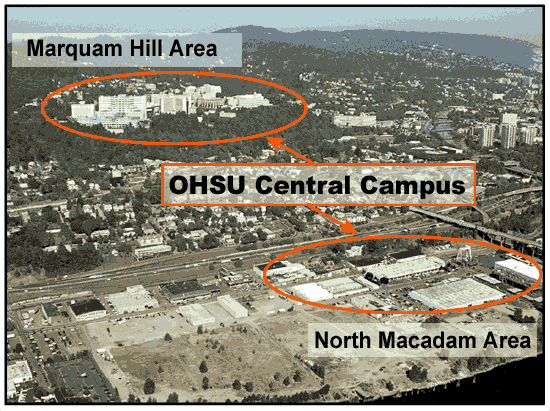 The North Macadam District offers a unique opportunity for redevelopment as it provides the largest block of vacant or underutilized land within the city's core. The North Macadam District has approximately 140 acres of land and 6,500 linear feet of waterfront along the Willamette River. It is bounded by the Marquam Bridge in the north, Hamilton Street in the south, Macadam Avenue in the west, and the Willamette River to the east. The North Macadam District offers a unique opportunity for redevelopment as it provides the largest block of vacant or underutilized land within the city's core. The North Macadam District has approximately 140 acres of land and 6,500 linear feet of waterfront along the Willamette River. It is bounded by the Marquam Bridge in the north, Hamilton Street in the south, Macadam Avenue in the west, and the Willamette River to the east.
At the heart of the North Macadam planning effort is is the fact the OHSU is out of space on it Marquam Hill Central Campus and has to seek land elsewhere.
Measuring Sprawl and Its Impact: The Character and Consequences of Metropolitan Expansion
Smart Growth America - October 2002 This ground-breaking, three-year study by researchers at Rutgers and Cornell measures sprawl in the most comprehensive way yet and confirms that, in sprawling places, people drive more, breathe more polluted air, face a greater risk of traffic fatalities, own more cars and walk and use transit less. Portland registered the eighth least urban sprawl of 83 metropolitan areas.
Portland State University: Quarterly & Urban Development Journal
The Portland State University Real Estate Center publishes a Quarterly & Urban Development Journal which is always a "good read." You can access the Portland State University Real Estate Center Web site at http://www.pdx.edu/realestate to download the journals.
Portland Development Commission
An ongoing debate within the city of Portland is whether the city council exercises too much authority over urban renewal projects. Many think that the Portland Development Commission should be more in control.
The Friends of Urban Renewal has not-so-quietly become one of Portland’s most powerful interest groups. It nearly squelched city efforts to steer downtown tax revenue toward an east side elementary school. It has forced the city to rethink extending the River District’s urban renewal area’s boundaries. And its refusal to stop fighting a land-use battle has city leaders quietly asking the Portland Business Alliance to rein it in. The group is dominated by former Portland Development Commission insiders largely frustrated that Portland’s City Council exerts too much power over urban renewal issues. It operates more as a think tank than as a political action committee. It doesn’t receive funding, save for donated legal advice from attorneys who support the group’s mission.
|
|
Keeping Chickens in Portland

Working Mothers
Question: How many chickens will the City of Portland allow on your property?
Answer: Three. Hens only as rosters are illegal (they crow early in the morning and wake your neighborhoods). No permit is required. See City of Portland Code Section 13.05.015, paragraph E.
Portland Chickens! is a group of volunteers who seek to promote the joy of chickens and freedom to design and build small structures without permit requirements. They are passionate about Urban Chickens for many reasons, here are a few: They bring us closer to the chain of life, they make great pets, fresh eggs, fertilizer for the garden, and they are Voracious Insect Eaters. The group has found a perfect match with non-profit Growing Gardens. Visit the Growing Gardens Web site - just scroll to the bottom of the "Resources" page to find the information about the chickens.
Visit the Omlet Web site to check out hen houses.
|
|
|
|