|
Portland Live Cams
-
Office Cam Watch the traffic go by and count umbrellas in downtown Portland at SW Washington Street and 11th Avenue.
-
OMSI Salmon Cam Watch the lifecycle of a Pacific Northwest salmon.
-
Oregon Cams All of the cams in Oregon to include 20 in Portland.
-
Surveillance Cameras in Portland Between 11 March 2003 and 15 March 2003, Bill Brown of the New York Surveillance Camera Players was in Portland, Oregon. Brought to the "Rose City" by the independent arts group Red76, Bill began his stay by making maps of locations of surveillance cameras installed in public places. Based upon information and suggestions he received from his gracious and very generous hosts, Bill mapped out two locations: Downtown Portland and Old Town.
-
U.S. Bankcorp Tower The KATU-TV Portland camera is located on top of the U. S. Bancorp Tower in Downtown Portland. From this vantage point the views include Mt. Hood to the East, the Willamette River to the North and South, Portland's West Hills, and a bird's-eye view of the downtown area.
-
Waterfront Park The Riverfront camera is located on a tower on the east side of the Willamette River near the Eastbank Esplanade. The view is of the Willamette River and downtown Portland, and I-5.
-
Portland Skyline & River
-
Various Portland City Sky Cams on KGW.Com
-
Portland Riverfront
-
Portland Airport
-
Portland Airport Cam from KGW
-
Pioneer Square from KGW.Com in Portland, Oregon
-
The Office Guy Cam in Portland, Oregon
-
OSHU Tram Cam
-
Oregon Live Office Camera in Portland, Oregon
-
Wells Fargo Center Cam in Portland
-
KOIN Center NE
-
KOIN Center SW
-
KOIN Transmittor
-
Rodgers Marine (nice view of river and marina)
Pacific Northwest Cams
-
Mountain Cams Live mountain cams throughout the world to include the Pacific Northwest Cascade Range.
-
Hood River Cam The KATU-TV Columbia Gorge camera is located high on the bluffs on the north side of the Columbia River across from the city of Hood River.
-
Oregon Maps Oregon State Map helps in locating the prominent features of the state. Location of various cities including the capital, rivers, counties, county seats, national parks, roadways, museums, railways and golf courses are highlighted in the state map of Oregon
-
Tripcheck Oregon Department of Transportation cam to view road conditions within Oregon and its surrounding states.
-
Northwest Cams By far the most extensive collection of cams - it sorts them by state (Alaska, Idaho, Montana, Oregon , and Washington).
Oregon Aquarium Cams
See what is going on at the Oregon Coast Aquarium day and night.
Virtual Tour
Virtual Guidebook's Tour of Portland and Oregon See the highpoints of Portland and Oregon.
Portland in 3D
Portland Bridges and City in 3D Fly through Portland model bridges in 3D or view the city in 3D.
I Love Portland Videos
I Love Portland For almost all of us, Portland is a special place. It may rain a lot, but if you can put up with that, you begin to understand why people come from all over the country to live here and why most of them stay. One way of examining that phenomena is to find some of the places that say something about Portland, about its quirkiness and its charm. That's exactly what The Oregonian did in 2009. And then they produced a series of videos to tell the city, and the rest of the world, about them. They calling the project I Love Portland. The list is long, and growing. More videos will come over time. Take a look. And e-mail your ideas for other spots around town that make Portland the city it is.
Images of Ancient Volcanoes, Landslides, and River Floodplains
Using a laser-based terrain mapping system, the Oregon Department of Geology and Mineral Industries has produced giant color images of the Portland basin, Mount Hood and the Columbia River gorge.
The images, created by chief scientist Ian Madin and measuring up to 5 feet by 8 feet, were produced using a mapping program called Lidar − light detection and ranging. The program allows technicians to manipulate the image data by stripping away vegetation and buildings to show a bare earth view.
The Portland basin image shows ancient volcanoes, remnants of where the Missoula floods came through 15,000 years ago, evidence of landslides, and river floodplains that are now covered by development.
Maps
Portlandonline.com is a rich resource of city maps (PDF format) that you can download and print. Most of them are 44" by 34" so it is best to zoom in on an area and then print "Current view."
Downtown Portland Map The Downtown Portland map shows an unprecedented level of detail. Galleries, public art, restaurants, coffeehouses, pubs & bakeries are clearly labeled on the map and in the index. Parking, mass transit, and key landmarks are shown. If your time is limited, you can see at a glance what areas have the greatest density of restaurants, pubs, or coffeehouses.
The NW23rd/Pearl District Gallery & Walking Map The combined Northwest District (aka Alphabet District, Nob Hill, or NW23rd) / Pearl Gallery map provides key information for Portland First Thursday gallery walkers. Galleries, public art, restaurants, coffeehouses, pubs & bakeries are clearly labeled on the map and in the index. Parking, mass transit, and key landmarks are shown. If your time is limited, you can see at a glance what blocks have the greatest density of galleries, bakeries, or restaurants.
|
|
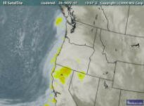
Satellite Cam

Fireworks on the River
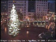
Pioneer Square
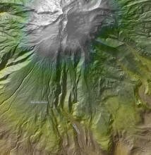
Image of Mount Hood Using LIDAR
|