|
Portland is located at the northern end of the Willamette Valley, a rich and diverse agricultural region. The long growing season and mild temperatures of the Willamette Valley are favorable for a diversity of agricultural products. Due to the high ground water level, irrigation is widely used to raise cannery crops, berries, grass seed, and pastures.
Portland (city center) is situated at 20 feet above sea level, near the confluence of the Columbia and Willamette rivers. Portland lies midway between the lower Coast Range to the west and the high Cascades Range to the east, each about 30 miles distant.
The skyline is dominated by two Cascades Range volcanoes, Mount St. Helens (8,300 feet high) about 40 miles northeast of Portland, and Mt. Hood (11,238 feet) about 40 miles to the east. Mount Jefferson defines the southeast edge. With some stretching here and tucking there, these landmarks coincide well with the edges of the CMSA (Consolidated Metropolitan Statistical Area). We can think of it as the areas that can now be reached in one and a half to two hours in a vehicle – roughly a seventy-five-mile radius around the original city.
City Layout - Four Quads
For a city that's split by a river, Portland is surprisingly easy to navigate by car, bicycle, or foot. The exception is traversing the West Hills as many of the streets curve and wind. The town is laid out in quadrants−north and south are divided by Burnside Street: east and west, by the Willamette River, which features a network of ten breathtaking bridges. You can get a good picture by viewing a Portland street map or try the Metro Quad map.
It took years for the city to adopt a uniform street system. The problem stemmed from the city's expansion in the late 19th century. Portland began in the late 1840s as a few blocks on the west side of the Willamette River. It wasn't long before it began taking up land north and south along the river and west toward the hills. Then it jumped the river to claim East Portland, Albina and St. Johns, plus neighborhoods in between and beyond. The upshot, said the late Eugene E. Snyder in Portland Names and Neighborhoods: Their Historic Origins was that "in the newly consolidated Portland of 1891 there were twelve "A" streets, twelve "B" streets, twelve "First" streets, nine "Cedar" streets and so on."
Finally in June of 1931, the Portland planning commission came up with a plan. The city was divided into five zones: Northwest, Southwest, North, Northeast and Southeast. East-west streets remained streets; north-south streets became avenues. There are some exceptions like Southeast Hawthorne Boulevard, Northeast Sandy Boulevard, and a few others. But for the most parts, the results followed the design.
Hills in the West and Flat in the East
Looking east from downtown Portland (20 feet above sea level) you immediately notice Mt. Hood (11,235 feet - about 40 miles from downtown), the Cascade Mountain Range, and the flat landscape of the east side across from the Willamette River.
Looking west you notice the hills and some of the houses - those not covered up by the greenery − that dominate the view. You imagine yourself in a house looking over the city and the mountains. Explore the east side more and you will encounter hilly terrain in certain neighborhoods like Mt. Tabor. Traveling south into Lake Oswego and West Linn, you also get into the hills.
Traveling west over the ridge of hills on the west side, you dip into a flat valley. Once in the Tualatin plains, looking west, your eyes will meet a gentle rising group of hills called the Coastal Mountain Range. The plains lay in the Hillsboro-Forest Grove-North Plains-Banks area of Washington County. The plains were once the most important agricultural district in the circle around Portland. In the 1830s Hudson' Bay Company employees from Fort Vancouver sometimes drove cattle over the muddy passes of the West Hills to fatten on summer grasses of the Valley. In the 1840s American wheat farmers pushed aside the British cattle. Today, the Tualatin Plains is mostly communities and industrial areas but crops still exist in a good share of the plains.
TopoZone will allow you to explore the elevations of Portland. You will note that within a mile of downtown heading west you are up to 500 feet. Drive up the winding streets and you will reach heights of over 1,000 feet.
City of Bridges
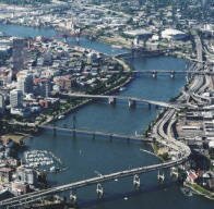 Portland is often called Bridge Town because ten bridges span the Willamette River in the metro area. The bridges of Portland are numerous and diverse. The structures, ranging in age from 30 plus years to 100 years of age, represent a variety of construction types including vertical lift spans, double-leaf Bascule drawspans, and the Fremont is the second longest tied arch span in the world. Andrew Hall's Bridge Gallery displays all ten of the bridges on your monitor. Portland is often called Bridge Town because ten bridges span the Willamette River in the metro area. The bridges of Portland are numerous and diverse. The structures, ranging in age from 30 plus years to 100 years of age, represent a variety of construction types including vertical lift spans, double-leaf Bascule drawspans, and the Fremont is the second longest tied arch span in the world. Andrew Hall's Bridge Gallery displays all ten of the bridges on your monitor.
Multnomah County maintains and operates these six Willamette River Bridges: Burnside, Broadway, Hawthorne, Morrison, Sauvie Island, and Sellwood bridges. The Oregon Department of Transportation maintains the Ross Island, Marquam, Fremont and St. John's bridges. The Union Pacific Railroad maintains the Steel Bridge. The Marquam and Fremont carry traffic over interstates highways.
River traffic has priority over cars. If a lone sailboat wants one of the lift bridges raised at 3 a.m. − or in the middle of rush hour − it must be done.
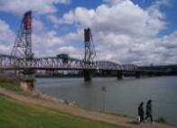 The Hawthorne bridge is the world's oldest vertical-lift bridge and most Portlanders consider it their favorite of the ten bridges. When closed, it's just 49 feet above the water. The Broadway Bridge, by comparison, is 85 feet above the water, the Morrison 69 feet. That means the Hawthorne rises and lowers more frequently − more than 200 times a month. The only time the bride is closed to river traffic is when we get ice or snow as just one-eighth of an inch of ice or one inch of snow adds too much weight to the span to open. The Hawthorne bridge is the world's oldest vertical-lift bridge and most Portlanders consider it their favorite of the ten bridges. When closed, it's just 49 feet above the water. The Broadway Bridge, by comparison, is 85 feet above the water, the Morrison 69 feet. That means the Hawthorne rises and lowers more frequently − more than 200 times a month. The only time the bride is closed to river traffic is when we get ice or snow as just one-eighth of an inch of ice or one inch of snow adds too much weight to the span to open.
The City of Roses becomes the city of bicycles in early August each year as upwards of 12,000 people pulled on brightly colored jerseys, clamped on helmets and grabbed cameras to join in the annual Providence Bridge Pedal.
The event, extraordinary for its route over eight of Portland's Willamette River bridges, draw Oregonians and out-of-towners of all ages. Children in bike buggies, couples on tandems and adults pedaling everything from sleek titanium racers to one-speed cruisers filled the streets and bridges from early morning until early afternoon.
Physical Features Impact Daily Living
Natural, physical features and climactic forces have considerable impact on the city, and on living in the city. Portlanders are rarely troubled by the rain, they appreciate, and delight in sunshine. Newcomers are heard to comment frequently on how green it all is. On clear days we can see Mt. Hood, Mt. St. Helens, Mt. Adams, and even Mt. Rainer.
West Hill Slides
During the winters of 1996-97, when the Portland area received record rainfall, the West Hills had over 350 slides (the entire metro area had 630 plus slides). The majority of the slides caused minor damages but a few wiped out homes and a some caused structural problems to homes. Many people were shocked to learn that their standard insurance policy didn't cover slides.
Most slides are small and shallow, the exceptions are undated prehistoric slides under what is now the Oregon Zoo and the Washington Park Rose Garden.
Because of the '96 slides, the City of Portland requires geotechnical engineers in slide hazard zones to drill soil samples, evaluate the firmness of underlying soils and measure depths to bedrock. The city requires geotechnical reviews at new building sites or for major remodeling projects, existing homes and buildings do not get the same scrutiny.
As a result of the renewed study, what became better known is that most of the homes in the West Hills are built on glacial loess − windblown glacial particles. The windblown silt ranges from a few feet deep in some places to 100 feet in others over basalt. Although most have survived just fine through decades of Oregon rainstorms, there can still be problems. Portland State University Bill Burns states that "The particles are not as packed together as they could be, which makes them more moisture sensitive. Combine that with the steep slopes and the risk for landslides goes way up."
Portland State University Study A comprehensive study by PSU geologists following the 630-some landslides that hit the region after the heavy rains of early 1996 found that "roughly 76 percent ... were linked to poorly planned land-use practices on steep or unstable slopes." They were often triggered by "uncontrolled storm-water runoff coming from roofs and streets that contributed to adjacent slope instability." To download the study, click here.
State geologists are now mapping the state with LIDAR − light detection and ranging − a system that gathers high-resolution images of the surface of the earth. It employs lasers that let scientists see landslides that occurred decades, even centuries, before. State and federal scientists will combine the LIDAR maps with geologic data and records of past landslides to identify levels of hazards throughout Portland.
The U.S. Geological Survey in 2006 also installed monitors at Mount Cavalry Cemetery in Northwest Portland to track rainfall and soil moisture, looking for a correlation between the two. That may allow them to better predict when the conditions are right for slides to occur.
Preventative Steps Homeowners compound that risk if they let water run off their roofs or lots onto the ground around their home. The most important preventative step is to route runoff away from homes so it doesn't infiltrate the ground and weaken the soil.
Trees
 Recognizing that a tree canopy can help combat climate change, and ultimately save society billions of dollars in combination with more conventional "gray" infrastructure, jurisdictions are stepping up to save existing stands and replant trees. Recognizing that a tree canopy can help combat climate change, and ultimately save society billions of dollars in combination with more conventional "gray" infrastructure, jurisdictions are stepping up to save existing stands and replant trees.
In the summer of 2008, Portland, known nationally for its well-treed image, launched "Grey to Green," a five-year, $50 million, green-up-the-city initiative that includes planting 83,000 trees − 50,000 of them along streets, increasing the city's street-tree inventory by about one-fourth. A number of suburban communities are also going green, with simultaneous efforts to save trees and reduce costs.
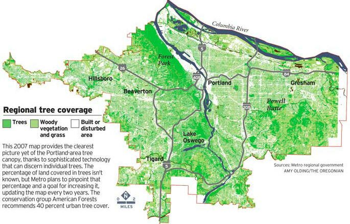
Portland has set a goal to increase its tree cover from 26 percent to 33 percent, propelled by a study it published (often cited by other jurisdictions) describing enormous public and environmental benefits from trees.
Among other things, the Rose City's street and park trees remove nearly 2 million pounds of pollutants and nearly 53 million pounds of carbon each year, according to the study, saving more than $3 million in services. Citywide, they also catch 1.3 billion gallons of storm water, according to the study, saving nearly $36 million on processing.
Urban plants and trees are thought to provide specific benefits. Kathleen Wolf, a researcher in the College of Forest Resources at the University of Washington, says studies suggest that neighborhoods with street trees have less crime, and those with plants and trees reduce stress and encourage healthy activities, like walking. Playing in a green environment, research shows, may encourage skill and cognitive development in children, as well as concentration and self-discipline.
Pavement shaded by trees can be as much as 40 degrees cooler on a hot summer day.
Since it began, Friends of Trees has planted 375,000 trees and shrubs. As part of Portland's Gray to Green Initiative, the organization plans to dramatically increase its efforts by planting 33,000 yard trees and 50,000 street trees during the next five years.
Heritage Trees
If ever there was a city of living Christmas trees, Portland is the place. Cedars, firs, pines, redwoods, spruces, all stand tall throughout the urban skyline.
Heritage Trees are trees designated by the Portland City Council as having special importance due to size, age, type or history. Portland now has close to 290 Heritage Trees that are still alive. To view a map of all the trees, click here.
-
Portland's very first Heritage Tree is an American elm at 1111 SW 10th Avenue. Its massive, leafy profile graces the front of the Portland YWCA building. It's called the Burrell Elm because it was planted in 1872 by Martin and Rosa Burrell.
-
The Douglas Fir is North America's most plentiful softwood species, accounting for one fifth of the continent's total softwood reserves. It is also the most common conifer in the Portland area. Macleay Park's 242-foot Douglas fir is probably more than 200 years old. If left uncut, Douglas firs live an average of 1,000 years.
Elevations (in feet)
City of Portland
Portland Airport (northeast - Columbia River): 20
Portland Waterfront (Willamette River): 30
Portland (City Hall): 70
Council Crest (southwest): 1,073
Mount Scott (southeast): 1,050
International Rose Garden in Washington Park: 400
Sunset Highway (Sylvan): 750
Terwilliger (OHSU entrance): 315
Hollywood neighborhood: 200
Highest point in the city just off NW Skyline Drive by Skyline Memorial Gardens: 1,180
Suburban Communities
Beaverton: 189
Damascus: 530
Estacada: 1,419
Gresham: 330
Hillsboro: 140
Lake Oswego (Mountain Park): 970
Lake Oswego (State Street): 100
Tigard: 66
Tigard (Bull Mountain): 711
Vancouver, Washington (Mill Plain Boulevard): 300
Vancouver, Washington (shipyards): 30
Distances
-
173 miles south of Seattle
-
639 miles north of San Francisco
-
250 miles from the California border via I-5
-
60 minutes from Mt. Hood
-
45 minutes from the wine country of the Willamette Valley
-
40 minutes from the spectacular Columbia Gorge
-
About 90 minutes from the picturesque Oregon Coast
|
Former Blazer
Clyde Drexler
on Portland

December 2003 quote from Clyde,
undoubtedly one of the most popular Blazers, while warming up before
joining a "pickup" game at the RiverPlace Athletic Club in Portland.
"It's a great place to live. We come back often, even in the winter."
Shipbuilder
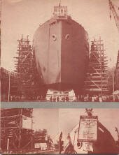
Between 1940 and 1944 the
Portland metropolitan population
grew from
501,000 to 661,000
as Portland raced to build
ships for
the war.
Portland Tree Canopy
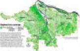
Click to enlarge.
Trees of Greater Portland
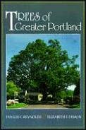
Phyllis Reynolds began studying Portland's trees in the 1980s. Phyllis is the co-author, with Elizabeth Dimon, of the guidebook Trees of Greater Portland (Timber Press, 1993), The book is crammed full of fascinating facts.
Bridge Pedal
Every August, the Portland bridge are closed to traffic so 10,000 plus bikers can enjoy the spectacular bridge views. The route includes biking over the top of the Marquam Bridge to the top of the Fremont Bridge along with 4-5 other bridges. You can choose to take the 25-mile ride or the 14-mile family ride.
Walking Map of Downtown
Powell's City of Book has an excellent walking map of downtown Portland.
Download it here.
The Rose City

Most residents of Portland, if asked, would name the rose as the Portland city flower, and consider "The City of Roses" as an official city name. Many would be surprised to know that not until 2003 did the City Council adopting the City of Roses as the city’s official nickname.
Charles Paul Keyser (Portland Parks Superintendent 1917-1950) stated that Portland was christened the City of Roses by visitors to an Episcopal Church convention which was held in the city in 1888 when the Portland Rose Society was formed. In 1889 Portland's first annual Rose Show was held and from 1904 through 1906 the Portland Rose Society sponsored a Fiesta along with its annual rose show.
City of Portland Official Flag

The four colors are blue, green, yellow and white. The blue represents the Columbia and Willamette rivers, the green signifies the forests that surround Portland, the yellow symbolizes wheat and the riches of commerce, and the white sets the colors apart.
Maps
Portlandonline.com is a rich resource of maps that you can download and print. Most of them are 44" by 34" so it is best to zoom in on an area and then print "Current view."
|