|
 Southwest Hills includes two well known neighborhoods: Portland Heights and Council Crest. Look into the west and slightly south from level ground in downtown and your eyes balls will be tilted upwards towards the hills of Portland Heights. Leaving downtown on West Burnside and heading south on Vista Avenue and after crossing the Vista Bridge (over Highway 26), you will began to notice stately homes. You're in Portland Heights. Travel further southwest past the Ainsworth Elementary School and the next stop is the neighborhood of Council Crest. Southwest Hills includes two well known neighborhoods: Portland Heights and Council Crest. Look into the west and slightly south from level ground in downtown and your eyes balls will be tilted upwards towards the hills of Portland Heights. Leaving downtown on West Burnside and heading south on Vista Avenue and after crossing the Vista Bridge (over Highway 26), you will began to notice stately homes. You're in Portland Heights. Travel further southwest past the Ainsworth Elementary School and the next stop is the neighborhood of Council Crest.
History
This area is where John B. Talbot first claimed land in 1851. Although Portland Heights is one of the oldest and most exclusive neighborhoods in Portland mainly because of its views and closeness to downtown, the area did not develop until the early 1900s. It was just too difficult to navigate the muddy roads. Once the roads were paved and the Vista Bridge was built in 1903, land prices quickly went from a few hundred dollars an acres to $10,000 by 1910. The flatter area around the midpoint of Vista Avenue, known as "The Grid," did attract residents to build summer cottages in the 1800s but those quickly disappeared and replaced by Colonials, Tudors, and other styles popular at the time when the area was developed.
The Portland Cable Railway started running a cable car up Vista Avenue to Council Crest Park in 1890. An amusement park was built on Council Crest in 1907 and continued operation until 1929. The city bought the land in 1936 and created Council Crest Park.
Origin of the Name of Council Crest
Council Crest got its name in 1898 from a group of delegates to a Congregational Church council who climbed the 1,073-foot hill and promptly named it after their gathering. Most likely the "Heights" in Portland Heights came about like all the other "Heights" names in the West Hills (e.g., Arlington Heights, King's Heights, Willamette Heights, etc.). Or perhaps it was the fact that Portland Heights offered a view of the city of Portland from the "Heights."
Southwest Hills Home Styles
Portland's Everclear musical group has a song with the line, "I will buy you that big house, way up in the West Hills." Everclear is from Portland and they are referring to the West Hills where Everclear's founder Alexakis lived in the late 90s. He actually lived in Portland Heights. The song got it right because Portland Heights has big homes as well as some of the most sought after home in the metro area. Over the years, they have almost been recession proof, offering owners a small but fairly consistent increase in value.
Southwest Hills homes have two attractions: downtown is only a short drive away and many of the homes have spectacular views. When you have a view of more than one mountain, such as Mt. Hood and St. Helens, it's called a two-mountain view. When these homes go on the market, the ad reads, "mountain view during the day and city view at night."
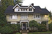 This charming Colonial in Portland Heights was built in 1916 and is one of the oldest homes on SW Sherwood Drive. It's a good example of the type of home that can be found in the neighborhood. The main level is welcomes you into a formal living room and beautiful dining room, both featuring grand fireplaces and quarter-sawn oak floors. The ‘green apple’ kitchen retains the old-house charm, but was recently renovated with all the modern conveniences, including antiqued granite countertops. From the downstairs basement to the top of the third floor, this very spacious and beautifully-designed home showcases a traditional style, updated to accommodate the needs of contemporary family life. This charming Colonial in Portland Heights was built in 1916 and is one of the oldest homes on SW Sherwood Drive. It's a good example of the type of home that can be found in the neighborhood. The main level is welcomes you into a formal living room and beautiful dining room, both featuring grand fireplaces and quarter-sawn oak floors. The ‘green apple’ kitchen retains the old-house charm, but was recently renovated with all the modern conveniences, including antiqued granite countertops. From the downstairs basement to the top of the third floor, this very spacious and beautifully-designed home showcases a traditional style, updated to accommodate the needs of contemporary family life.
Portland Heights has a few condos whereas Council Crest is all detached single-family homes.
1Southwest Hills Home Prices
-
Number of homes sold in Southwest Hills in 2010: 105. Distress properties sales were 7%.
-
Median price for homes sold in Southwest Hills: $560,000 in 2010; $635,000 in 2009; $644,500 in 2008; $755,000 in 2007.
-
1-year median sales price change in 2010 from 2009 in Southwest Hills: -3%.
-
5-year median sales price change in Southwest Hills: -6%.
-
Metro area median home prices: $239,900 in 2010; $247,000 in 2009; $278,000 in 2008; $290,000 in 2007.
-
Metro area average home prices: $282,100 in 2010; $289,900 in 2009; $330,300 in 2008; $342,000 in 2007.
Please be aware that the above figures are subject to error and are intended as guidelines only. View Portland Heights and Council Crest homes currently for sale by clicking here.
Parks in the Neighborhood
The neighborhood has four parks. Here's a rundown on each:
-
Governor's Park This 5.41 acre park is for walking. It's located at SW 13th Ave & Davenport Street and has some interesting history. The park got its name (Governor's Park) when Sylvester Pennoyer, Governor of Oregon (1894-1901), gave the city the 5.3 acres. Pennoyer was the first person to make a gift of property to the city of Portland for solely park purposes.
-
Marquam Nature Park The park is a linear trail that starts south of downtown at the foot of the West Hills. It supports an abundance of native plant species, and has several trails that wind up the hill and through trees such as Douglas fir, Western hemlock, Red cedar, and Bigleaf maples.
-
Portland Heights Park The 5.3 acre park at SW Patton Road & Old Orchard Road includes a basketball court, paths, picnic tables, playground, soccer field, softball field, and tennis court.
 The "crown jewel" of the Council Crest neighborhood is the 43-acre Council Crest Park. It includes a dog off-leash area, paths, picnic tables, statue or public art, vista point, and wedding site. The "crown jewel" of the Council Crest neighborhood is the 43-acre Council Crest Park. It includes a dog off-leash area, paths, picnic tables, statue or public art, vista point, and wedding site.
In July 1956, a welded, sheet bronze drinking fountain featuring a mother and child was installed in the park. Sculpted by Frederic Littmann, an associate professor of art at Portland State College, it has been mistakenly identified as a pioneer woman. The sculptor said the statue did not represent a particular era; it was simply a mother and child playing in the park and depicts joy. The photo at the top of this page is the pioneer woman.
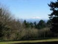
Council Crest Park is one of the highest points in the metro area at 1,071 feet above sea level. On a clear day, the view from Council Crest is unbeatable. You can view many of the highest peaks in the Cascade Range. From the top of the hill, one can see five mountains in the Cascade Range: Mt. Hood, Mt. St. Helens, Mt. Adams, Mt. Jefferson, and Mt. Rainier (100 miles to the north). In addition, the park boasts a fantastic 180 degree view of Portland and surrounding towns.
Southwest Hills has 164 acres of park land and open spaces according to Metro and the Portland Department of Parks and Recreation.
Cable Cars
 The Portland Heights trestle opened in 1890 and paved the way for people to live in the Southwest Hills neighborhood. The trestle went all the way up to SW Spring Street which begins by the Ainsworth Elementary School. The Portland Heights trestle opened in 1890 and paved the way for people to live in the Southwest Hills neighborhood. The trestle went all the way up to SW Spring Street which begins by the Ainsworth Elementary School.
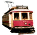
A streetcar line to the top of Council Crest was completed in 1906. It was the most scenic and spectacular streetcar line in the Northwest because once at the top, you have views of the Cascade Mountain Range. The photo to the left is one of the streetcars. The 'cow catcher' (aka a bumper) in front of the car reads, "See Portland from Council Crest."
Walking in the Southwest Hills Neighborhood
-
Portland Heights to Zoo Walking Tour This 5.6-mile walk combines stunning views of downtown and the Cascades, 19th century homes, wooded paths and a ride on Portland's only subway. Stop for a snack at Strohecker's Grocery on your way to an afternoon visiting the Oregon Zoo. Click here to download the guide.
-
Southwest Trails Group The SW Trails Group is a committee of Southwest Neighborhoods Inc that uses volunteer efforts to make trail improvements, lead walks, work with Safe Routes to School, plan and advocate for pedestrian and bicycle safety and other improvements in SW Portland Their walks are the second Saturday of each month, meet at 9 a.m. sharp under the Hillsdale Oak, behind the Dance Studio at SW Sunset Blvd and SW Capitol Highway near the concrete bleachers of the Wilson football field.
Walk Score ranks 2,508 neighborhoods in the largest 40 U.S. cities to help you find a walkable place to live. Southwest Hills is the #48 most walkable neighborhood in Portland. This neighborhood is Somewhat Walkable with an average Walk Score of 54. Below is a Walk Score for an address in the center of the Southwest Hills neighborhood.
More About Southwest Hills
-
Neighborhood Association Web Site The neighborhood does not have a Web site. Take a historical tour of homes on Montgomery Avenue (PDF format).
-
Location of Neighborhood Southwest of downtown. Get on Southwest Vista and take a tour of the neighborhood. See Southwest Hills in PDF format.
-
2Drive Time to Downtown 12-13 minutes.
-
Topography Moderate hilly in Portland Heights and quite hilly in Council Crest. Mature trees in yards in parks.
-
Street and Sidewalks Many of the side streets are narrow. All of Portland Heights have walkable sidewalks whereas Council Crest have a few sidewalks.
-
Livability Study 96% of Southwest Hills residents rated their neighborhood "good" or "very good." Healy Heights was combined with Southwest Hills in the study. See Livability Study.
-
Public Transportation A number of bus routes connects the Southwest Hills with the rest of Portland. See the Vista - 51 at the TriMet Web site. Transit Score provides a 0-100 rating indicating how well an address is served by public transportation. Ratings range from "Rider's Paradises" to areas with limited or no nearby public transportation.
-
32000 Demographics Population: 4,673 Persons. Area (acres): 1,310. Average population density: 3 persons per acre. Number of households: 1,992. Homeowners versus renters: 84 percent owners. Median household income: $102,730. Diversity: 11% non-Caucasian.
-
4Crime Stats for 2010 No violent crimes. Total crimes per 1,000 people was 12. For the latest crime statistics for the Southwest Hills neighborhood, click here.
-
Sex Offenders Click here for the State of Oregon Sex Offender Inquiry System. After agreeing to the "Conditions of Use Statement" you will be redirected to a "Enter Search Criteria" page. Insert a zip code in the "Zip" field and click on the "Query" button. Southwest Hills zip code(s): 97201 and 97239.
-
5Shopping and Services Number of supermarkets: 1. Number of hardware stores: 0. Number of coffee shops: 0.
Stroheckers, a landmark store for many of the residents needs includes; groceries, deli, pharmacy, and liquor. Stroheckers is located at 2855 SW Patton Avenue.
-
Eating Out One restaurant and it's worth a stop - the Vista Spring Cafe located at the intersection of SW Vista Street and SW Spring.
-
Who Lives in the Southwest Hills Well established people especially in Portland Heights which has some of the most expensive housing in Portland. This is a white-collar neighborhood. The median age is 45.
-
Cars in the Neighborhood Expensive real estate so you'll see expensive cars to include Audis, BMWs, Mercedes, and other luxury autos along with a second car which is usually a SUV.
-
6Biking Quality is low. Southwest Hills has 15 miles of bike lanes.
-
Schools Elementary school: Ainsworth. Middle school: East-West Sylvan. High school: Lincoln High School and Wilson High School.
-
7School Report Card Grades Elementary school: O. Middle schools: O High schools: O. Click here for report card details.
Map of Southwest Hills
View Larger Map
Fly to the Southwest Hills Neighborhood via Google Earth
__________________________________________
1Real Estate Values Data on real estate values provided by RMLStm. Distressed properties refer to the percentage of total homes sold that were short sales and bank-owned properties.
2Drive Time to Downtown Estimated commuting time obtained from Yahoo Maps and Google Maps. Drive time was calculated from a central intersection in each neighborhood to Pioneer Courthouse Square during the morning peak commute time.
3Demographics Data Numbers were obtained from Census 2000 and www.portlandmaps.com.
4Crime Statistics Numbers on crime represent total crimes for 2010 and were obtained from Portland Police Bureau. Violent crimes are defined as murder, rape, robbery, and aggravated assault. Crimes per 1,000 are based on reported incidents of violent crime, as well as burglary, larceny, and motor vehicle theft.
5Shopping and Services Numbers were determined from local directory listings and county/municipal library systems.
6Biking Quality rating based on the 2007 Cycle Zone Analysis conducted by the City of Portland Office of Transportation. The six-tier ratings have been reduced to three levels: High, Fair, and Low.
7School Report Card Grades Schools ratings from the Oregon Department of Education 2009-2010 performance assessment. "O" = Outstanding; "S" = Satisfactory; "I" = In Need of Improvement; NR = Not Rated.
|
|
View
Southwest Homes
for Sale

Southwest Hills
Homes
for Sale
|
Southwest Hills Boundaries
North: Highway 26 (Sunset Highway).
South: Southwest Patton Road on the west end and Southwest Broadway on the east.
East: I-405.
West: Southwest Scholls Ferry Road.
Map Showing Neighborhood Boundaries
Southwest Hills
|

To learn more about the Southwest Hills neighborhood
visit Portland Maps.
It will provide you with a list of businesses, demographic data,
crime stats, parks, schools, aerial photos, maps,
elevation, etc.
All you need is a property address − use
"3574 SW Council Crest Drive"
|
Learn More
About
the
Southwest Hills
Neighborhood

West Hills Parks
West Hills Parks
|
Tudor for $739,000
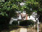
Historic Tudor built in 1928 and updated. Grand living and dining rooms, den with built-in bookshelves, two fireplaces and hardwood floors throughout. Large master suite with sun room, and 2-car attached garage.
|