Long and narrow − four-miles long along the west bank of the Willamette River − is the South Portland neighborhood. Running down the north-south length of the neighborhood along the east side is Highway 43 (also called SW Macadam Avenue). About three miles of the four miles road through the neighborhood contains commercial properties − this includes retail, restaurants, shops, and an upscale food market. Macadam Avenue is a busy street, especially in the morning and late afternoon as commuters crowd the road. Traffic backs up for blocks trying to cross the Sellwood bridge. The saving grace is that the road does have a median strip that makes driving tolerable. You can view a list of the business by visiting the South Portland Business Association.
The neighborhood is found east of I-5 between the Terwilliger Curves and Willamette River. From downtown Portland this neighborhood can be reached by traveling along Naito Parkway towards the Ross Island Bridge and taking the Macadam Avenue turn off immediately before continuing across the Ross Island bridge. The neighborhood along the river is referred to as Johns Landing.
South Portland is a collection of a number of different neighborhoods:
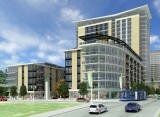
South Waterfront The northeastern part of the neighborhood called South Waterfront (SoWa) is the site of a large-scale, high-density district currently under construction. Oregon Health & Science University (OHSU) ran out of room on its upper campus and they are expanding along the river.
Lair Hill This area is in the northwestern part of the neighborhood, bordered by I-405 on the north, SW Barbur Boulevard on the south and west, and SW Naito Parkway on the east. This area was part of historical South Portland, a district of Italian, Irish, and Jewish immigrants much of which was demolished by an "urban renewal" project in 1958. Vestiges remain in the form of synagogues and ethnic shops.
Corbett The Corbett area (and SW Corbett St. running north-south through the entire neighborhood) lies east of Lair Hill, bounded by I-405 on the north, SW Naito Parkway on the west, SW Macadam Avenue on the east. Its southern boundary is marked by the SW Corbett St. bridge over I-5. This area of Portland should not be confused with the unincorporated community of Corbett, Oregon in eastern Multnomah County.
Terwilliger This area lies south of Corbett, between SW Barbur Boulevard and SW Macadam Avenue.
Johns Landing The area used to be known as Fulton. It's found East of I-5 between the Terwilliger Curves and Willamette River. This section is along the river and there are numerous condos, many with river views.
For the last few years, the area's riverfront has been converting from heavy industry to residential development at a density that is expected to double the neighborhood's population. Offices and health care facilities employing several thousand have located along the river.
OHSU Tram The neighborhood now has an icon: The OHSU Tram. Opened in late 2006, the tram links OHSU's Marquam Hill Campus to its first building in the river blocks. The Portland's Aerial Tram transports researchers, students, medical professionals, patients and visitors between Portland's foremost medical institution and its newest development. The 3,300-foot tram extends from the main Marquam Hill campus to a terminus at Southwest Gibbs Street and Moody Avenue near the Willamette River.
The City of Portland is working to build a new bike and pedestrian bridge over I-5 to connect the historic Lair Hill neighborhood with the South Waterfront District. The Gibbs Street Pedestrian Bridge will span approximately 700 feet, and will have a landing on the west side near the intersection of SW Gibbs Street and SW Kelly Avenue and on the east side near the intersection of SW Gibbs Street and SW Moody Avenue. The bridge will be adjacent to the aerial tram and will include improvements to some pedestrian crossings in the area. Work activities began during the week of January 10, 2011. Construction work is expected to last one year.
History
The South Portland Historic District was built between the 1870s and the 1920s and it was the home to Italian and Jewish immigrants. The area thrived in the early years since the population of Portland, all on the west side (East Portland was a separate city), was increasing rapidly and the area was a relatively easy place to develop, being a broad bench between the river and the West Hills. The first streetcars in the mid 1870s helped spur growth.
The decline started in the 30s when immigrants moved on to newer, most upscale neighborhoods in Portland. In the 50s, homeowners left for the suburbs and outlying neighborhoods. In the 70s, Corbett and Lair Hill was the area to get your hash pipe and other countercultural sundries. The construction of I-5 in the 60s devoured more of the streets and long-time neighbors were now cut off. Attracted by the cheap rents, students from Portland State University, Lewis and Clark College, and Oregon Health and Science University moved in. The area was dying, full of renters, and the prospects for the neighborhood looked dim. By the 70s, the neighborhood was discovered or perhaps rediscovered. Maybe by the educated people who were its renters. Activists realized its potential − live close to downtown in a historic home and buy it for the right price. Now that bungalow, purchased in the 70s - 80s for a song and renovated, is worth 4-5 times as much.
The Portland "neighborhood revolution" started in the South Portland community. The community organized in 1969 to fight the South Auditorium urban renewal project. The city wanted to clear parts of the Lair Hill neighborhood, located just south of the downtown urban renewal zone. Three other neighborhoods joined to develop their own district plan to preserve fragments of old South Portland and Fulton. This backlash resulted in establishment of the Lair Hill Historic Conservation District, the first protected historic district in Portland. This was followed by other Portland neighborhoods protesting other urban renewal projects.
Origin of the Names of Corbett, Terwilliger, Lair Hill, and Johns Landing
Senator Henry Winslow Corbett was one of Oregon's prominent pioneer citizens and for many years a resident of Portland. Terwil was a station on the Oregon Electric Railway and served the Terwilliger Park subdivision. William Lair Hill was a distinguished lawyer, author, and versatile writer who moved to Oregon in his youth during the early 1850s. Note that the 'Hill' in the Lair Hill neighborhood does not refer to a physical hill but to William Lair Hill. He became one of the nation's great constitutional lawyers. Johns Landing refers to the B. P. John Furniture company, the largest of many manufacturers in the area in its industrial past, as well as architect John W. Storrs and John D. Gray, who privately transformed the area into a riverside residential and commercial development.
The neighborhood, formerly known as Corbett-Terwilliger-Lair Hill or CTLH, changed its name at a meeting of its neighborhood association in 2006 to be more concise and inclusive. South Portland was the name of a 19th century community that overlapped the present day neighborhood. This area was part of historical South Portland, a district of Italian, Irish, and Jewish immigrants much of which was demolished by an "urban renewal" project in 1958.
South Portland Home Styles
I doubt if any other neighborhood in Portland has the variety of homes that exist in the South Portland community. There are new high-rise riverfront condos, historic homes, new townhomes, apartment buildings, and even new detached single-family homes. The first homes, built in the 1870s, were mostly Victorian and home to workers at nearby docks, warehouses, and riverside industries.
The terrain is flat along the river and starts rising just west of Macadam Avenue so many of the homes in the hills have views of the river and Cascade Mountain range. The same holds true for the high rise condos along the river, especially those in South Waterfront.
Affordable? Condos can be found in the $200s and townhomes for just over 300,000.
The South Portland Historic District was added to the National Register of Historic Places in 1998. The district is roughly bounded by Arthur, Front, Grover, Hood, and Curry Streets, and Barbur Boulevard. It has 186 buildings in the 490 acre historic district. Styles include late 19th and early 20th Century American Movements as well as Victorian.
1South Portland Home Prices
Number of homes sold in South Portland in 2010: 229. Distressed properties sales were 14%.
Median price for homes sold in South Portland: $305,000 in 2010; $299,500 in 2009; $373,000 in 2008; $349,000 in 2007.
1-year median sales price change in 2010 from 2009 in South Portland: -1%.
5-year median sales price change in South Portland: -19%.
Metro area median home prices: $239,900 in 2010; $247,000 in 2009; $278,000 in 2008; $290,000 in 2007.
Metro area average home prices: $282,100 in 2010; $289,900 in 2009; $330,300 in 2008; $342,000 in 2007.
Please be aware that the above figures are subject to error and are intended as guidelines only. View the South Portland homes currently for sale by clicking here.
Parks in the South Portland Neighborhood
The neighborhood has a park for just about every need. The 3.24 acre Lark Hill Park (SW 2nd Avenue and Woods Street) was given to the city by Multnomah County in 1927. Two buildings of historical interest are located in the park. The main building was constructed out of brick in 1918 in the Modified Georgian Revival style. In 1942, the State Architect's Office extensively remodeled it to serve as the Youth Administration of the Federal Security Agency. In 1949, the Park Bureau created a Junior Museum in the building, later renamed the Children's Museum, until it was relocated to the former OMSI building in Washington Park in 2001.
The smaller building, the Customs House, was built in 1921 as a branch of the county library. The building, Italian Renaissance Revival, once served as one of seven Carnegie-funded branch libraries in Portland. The library housed a collection of books in Yiddish, German, Polish, and Italian, as well as English before being converted to an art center by the Park Bureau in the early 1950s. Today the building is used as office space for Portland Parks and Recreation staff.
At the west end of the park, a sculpture of metal boulders by Bruce West represents a rock grotto which once stood in the park and provided a shady place where older men gathered on hot summer days to play chess. It was installed in 1978 and is entitled simply BW1.
Here are two parks located on the Willamette River:
Willamette Park is located at the south end of the neighborhood along the Willamette River on 26.85 acres. The attractions are a boat dock/boat ramp, dog off-leash area, soccer field, children's play area, and tennis courts. Nearby features include segments of the Willamette River Greenway Trail and the adjacent Willamette Butterfly Park, and the historic Lair Hill neighborhood.
Butterfly Park is a one-acre undeveloped Willamette River shoreline, along the Willamette Greenway. Its a good example of the natural environment of the river. Many cottonwood trees grow in the wet soil, while different species of birds, insects, and native plants flourish in this nature sanctuary. The park was named 'butterfly' for its importance as a habitat for butterflies.
In the 90s, volunteers organized by the neighborhood association started meeting every so often on weekends to pull invasive plants out of Butterfly Park. That project has mushroomed to include a much expanded area and many partners. Visit the South Portland Riverbanks Projects Web site to learn more.
South Portland has 63 acres of park land and open spaces according to Metro and the Portland Department of Parks and Recreation.
Willamette Greenway Trail
This trail is public that is on private land and runs along the Willamette River. Designed for for bikers, runners, and walkers only − no motorized vehicles.
Maintained by the Johns Landing Homeowners Association, the trail is wide enough (eight feet in most places) to accommodate both bikers and walkers. Many bike commuters use the trail to travel back and forth to work downtown and at OHSU. It starts south of South Waterfront and ends at the Sellwood Bridge. Along the way are a number of marinas including the Willamette Sailing Club. The river always hold some attractions such as waterfowl, sail boats, and you may even see an eagle. Trees along the river bank block views of the river along the northern part of the trail but once they shed their leaves in the fall, the river reappears.
Biking to Work in Portland
To bike from South Portland to downtown, you have two routes: Take the off-street (no motor vehicles) path along the river and then the painted bike lanes on SW Moody. The other choice is to take SW Barbur (painted bike lanes) into downtown. Download the SW Bikes Routes map for details. You can also use byCycle bicycle trip planner, a free online tool to help both new and seasoned cyclists plan safe trips through the city. This private Web site was created by cycling enthusiasts volunteering their time, with support from Metro.
Here's a New York Times video about biking in Portland.
Walking in South Portland
Two of the better walking tours in Portland is the Lair Hill tour and the Historic South Portland tour. Below are links to the guides and a brief explanation of the tours:
Lair Hill Tour The Lair Hill tour includes a variety of interesting places to include a children's museum, a couple of neighborhood homes, Lair Hill Park, and an Art Center.
Historic South Portland This 4.7-mile walk explores historic South Portland, site of immigrant Jewish and Italian communities in the early 1900s, and then loops back along the Willamette River Greenway Trail and into the evolving South Waterfront District. Along the way are parks, beautiful 19th century homes, quiet streets, and vies of Ross Island.
Laura Foster's 3.25 mile "South Portland to South Waterfront Park Loop" is the ultimate walk if you want some exercise and history. Her 2008 book, Portland City Walks is Laura's second book about walks. Her first book, Portland Hill Walks, is a treasure and many of her fans thought she would never be able to equal that gem. But she did. Laura actually has three books about walking. Her Walk There! was published in June 2008 by Metro, the Portland-area regional government, and funded by Kaiser Permanente.
Walk Score ranks 2,508 neighborhoods in the largest 40 U.S. cities to help you find a walkable place to live. South Portland is the #28 most walkable neighborhood in Portland. This neighborhood is 'Somewhat Walkable' with an average Walk Score of 68. Below is a Walk Score for an address in the center of the neighborhood.
More About South Portland
Neighborhood Association Web SiteSouth Portland represents South Waterfront, Corbett, Johns Landing, and Fulton neighborhoods. The neighborhood is often called Corbett-Terwilliger-Lair Hill.
Location South Portland is a long narrow neighborhood just south of downtown, hemmed in between the Willamette River and the West Hills. It stretches from I-405 and the Marquam Bridge on the north, to SW Canby Street and the Sellwood Bridge in the south. The Willamette River forms the eastern boundary, and SW Barbur Boulevard most of the western boundary
2Drive Time to Downtown A few minutes is you live on the north end but at least 10-11 minutes from the south end of the neighborhood.
Topography Generally flat with hills west of MacAdam. Mature trees.
Sidewalks and Streets Grid pattern of streets with blocks that are very long or short. Most of the neighborhood has sidewalks - the exception being those closer to the river.
Livability Study 91.3% of the South Portland residents rated their neighborhood "good" or "very good." See Livability Study.
Public TransportationTriMet has over 20 bus routes through the neighborhood. No MAX light rail or streetcar line. Check back in a few years and you may find that the streetcar line has been extended into the neighborhood. Transit Score provides a 0-100 rating indicating how well an address is served by public transportation. Ratings range from "Rider's Paradises" to areas with limited or no nearby public transportation.
3Demographics Population: 5,079. Area size: 1,069 acres. Average population density: 4 persons per acre. Number of households: 2,904. Median household income: $62,356. Percent of home owners: 42. Percent of renters: 58. Diversity: 19% non-Caucasian.
4Crime Stats 2010: Five violent crimes. Total crimes per 1,000 residents was 44. For the latest crime statistics for the South Portland neighborhood, click here.
Sex Offenders Click here for the State of Oregon Sex Offender Inquiry System. After agreeing to the "Conditions of Use Statement" you will be redirected to a "Enter Search Criteria" page. Insert a zip code in the "Zip" field and click on the "Query" button. South Portland zip code(s): 97201, 97219, 97239.
4Shopping and Services number of supermarkets: 1. number of hardware stores: 0. number of coffee shops: 2. Zupans, one of Portland locally owned food markets is located at 7221 SW Macadam Avenue. For a shopping change, take the one mile drive on Taylors Ferry Road off Macadam Avenue to Market of Choice. Their meat counters are full of Oregon beef, pork, and lamb and the seafood is West Coast caught whenever possible. Also organic produce and many gluten-free items.
Eating Out Stores and restaurants from one end of the neighborhood to the other on SW Macadam Avenue. It's about a ten minute drive to the Sellwood area in southeast Portland where you can find even more choices.
Public Library It's about a ten minute drive to the Sellwood-Moreland branch or you can head downtown to the main one - see Multnomah County Central Library.
Who Lives in South Portland Well over half of the residents possess a college degree. This means lots of white collar professionals, young married couples and singles. They run, visit the health club, and eat at the numerous restaurants on Macadam Avenue. The median age is 39.
Autos in the Neighborhoods Loads of practical foreign cars, Subaru Outbacks, and a couple pickups and SUVs. No Caddies or Lincolns.
6Biking Quality is fair. South Portland has 14 miles of bike lanes.
1Real Estate Values Data on real estate values provided by RMLStm. Distressed properties refer to the percentage of total homes sold that were short sales and bank-owned properties.
2Drive Time to Downtown Estimated commuting time obtained from Yahoo Maps and Google Maps. Drive time was calculated from a central intersection in each neighborhood to Pioneer Courthouse Square during the morning peak commute time.
3Demographics Data Numbers were obtained from Census 2000 and www.portlandmaps.com.
4Crime Statistics Numbers on crime represent total crimes for 2010 and were obtained from Portland Police Bureau. Violent crimes are defined as murder, rape, robbery, and aggravated assault. Crimes per 1,000 are based on reported incidents of violent crime, as well as burglary, larceny, and motor vehicle theft.
5Shopping and Services Numbers were determined from local directory listings and county/municipal library systems.
6Biking Quality rating based on the 2007 Cycle Zone Analysis conducted by the City of Portland Office of Transportation. The six-tier ratings have been reduced to three levels: High, Fair, and Low.
7School Report Card Grades Schools ratings from the Oregon Department of Education 2009-2010 performance assessment. "O" = Outstanding; "S" = Satisfactory; "I" = In Need of Improvement; NR = Not Rated.
The neighborhood is a long, varied strip south of downtown, roughly from the Marquam to Sellwood bridges and from Barbur Boulevard (west boundary) to the Willamette river (east boundary).
To learn more about the
South Portland neighborhood
visit Portland Maps.
It will provide you with a list of businesses, demographic data,
crime stats, parks, schools, aerial photos, maps,
elevation, etc.
All you need is a property address − use
"836 SW Curry Street"
Learn More
About
the
South Portland
Neighborhood
The Neighborhood House
This solid brick building was erected in 1901 Portland chapter of the National Council for Jewish Woman. The building as a whole cannot be identified as "a style," but borrows from the historic vocabulary, so it is termed Period Architecture.


 Long and narrow − four-miles long along the west bank of the Willamette River − is the South Portland neighborhood. Running down the north-south length of the neighborhood along the east side is Highway 43 (also called SW Macadam Avenue). About three miles of the four miles road through the neighborhood contains commercial properties − this includes retail, restaurants, shops, and an upscale food market. Macadam Avenue is a busy street, especially in the morning and late afternoon as commuters crowd the road. Traffic backs up for blocks trying to cross the Sellwood bridge. The saving grace is that the road does have a median strip that makes driving tolerable. You can view a list of the business by visiting the
 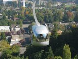 OHSU Tram The neighborhood now has an icon: The OHSU Tram. Opened in late 2006, the tram links OHSU's Marquam Hill Campus to its first building in the river blocks. The
 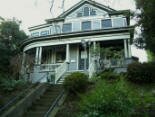 I doubt if any other neighborhood in Portland has the variety of homes that exist in the South Portland community. There are new high-rise riverfront condos, historic homes, new townhomes, apartment buildings, and even new detached single-family homes. The first homes, built in the 1870s, were mostly Victorian and home to workers at nearby docks, warehouses, and riverside industries.
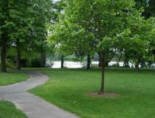 The neighborhood has a park for just about every need. The 3.24 acre
  Yiddish, German, Polish, and Italian, as well as English before being converted to an art center by the Park Bureau in the early 1950s. Today the building is used as office space for Portland Parks and Recreation staff.
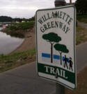 This trail is public that is on private land and runs along the Willamette River. Designed for for bikers, runners, and walkers only − no motorized vehicles.