| Subscribe to the Moving to Portland Newsletters |
53°F
52°F / 70°F
54°F / 58°F
51°F / 57°F
Guide to the Boise Neighborhood in Portland, Oregon
 In the mid-1980s, maybe 5-6 businesses were operating on the five-block North Mississippi Avenue commercial strip between Fremont and Skidmore streets in the Boise neighborhood of North Portland.
It was a grim place! You name it, N. Mississippi had it: drugs, gangs, street crime, prostitution, abandoned houses — all the elements of urban decay. Today, there are more than 40 businesses on the street. Restaurants, coffee shops, a bike shop, a nursery, furniture makers, a home rebuilding center, and even a couple of recording studios. Take a virtual shopping trip on Mississippi Avenue by clicking here.
What happened? For one thing, in 1999 the city of Portland created the Mississippi Historic District Target Area to improve public safety, upgrade housing and attract businesses. The city brought an army of bureaucratic tools — including home improvement loans, technical assistance and help — in dealing with the new designation. And the results are now starting to play out.
Has the effort been a success? The city hasn’t succeeded entirely in making sure that gentrification doesn’t drive out existing residents. Yes, crime and drugs are down while optimism is up. But the area still deals with undercurrents of racial and class mistrust in one of Oregon’s poorest and most diverse neighborhoods. Changes are happening quickly. People walk to the shops by day; at night, live music can be found at the Mississippi Pizza Pub where crowds and the music spill out onto the sidewalk on warm evenings.
The new Interstate MAX line is three blocks away, and neighbors hope that the low rents will attract more young artists who will help continue the revival. More than 60 percent of the neighborhood today is under 35, census figures show.
Mississippi Avenue Street Fair
The Mississippi Avenue Street Fair began in 2001 as a simple community-building event called the Boise-Eliot Multicultural Fair. The one-day event has since become Portland biggest street fair — attracting thousands and sprawling over five city blocks in the heart of the Historic Mississippi Avenue Business District.
The attractions have grown along with the fair and there are now multiple stages of entertainment with nearly 30 acts performing. Historic Mississippi Avenue Business Association (HMBA) and Boise Neighborhood Association (BNA) are the fair sponsors and it benefits the Boise-Eliot Elementary and Albina Youth Opportunity schools.
History
North Mississippi Avenue was populated in the 1800s by ship workers of European descent. It became home to blacks after the 1948 Vanport flood and was part of Portland’s thriving postwar black community. In the 50s and 60s, construction of Interstate 5 and Memorial Coliseum tore out businesses and long time neighbors were cut off from each other. The neighborhood has gone through a revival starting in the early 2000s and is now one of the most interesting areas in Portland.
Origin of Name
Reuben Patrick Boise (June 9, 1819 – April 10, 1907) was an attorney, judge and politician in the Oregon Territory and the early years of the state of Oregon. A native of Massachusetts, he immigrated to Oregon in 1850, where he would twice serve on the Oregon Supreme Court for a total of 16 years, with three stints as chief justice.
1Boise Home Prices
- Number of Homes Sold in Boise—► 32 homes sold in 2011 and 16% were distressed sales. 38 home sold in 2010 and 8% distressed properties sales.
- Average Price for Homes Sold in Boise—► $276,479 in 2011.
- Median Price for Homes Sold in Boise—► $273,050 in 2011, $299,950 in 2010, $274,000 in 2009, and $300,000 in 2008.
- 1-Year Median Sales Price Change in Boise—► 2011 the sales price change was -9%. 2010 the change was 9%.
- 5-Year Average Sales Price Change in Boise—► 2007 to 2011 the sales price change was -7%. 2006 to 2010 the change was 2%.
- Portland Metro Area Median Home Price—► $221,000 in 2011, $239,900 in 2010, $247,000 in 2009, $278,000 in 2008, and $290,000 in 2007.
- Portland Metro Area Average Home Price—► $263,300 in 2011, $282,100 in 2010, $289,900 in 2009 $330,300 in 2008, and $342,000 in 2007.
Please be aware that the above figures are subject to error and are intended as guidelines only.
Boise Homes for Sale
Parks and Health Clubs
Denorval Unthank Park is a 4.5 park in the heart of the Boise neighborhood. Facilities include a softball field, soccer field, basketball court, and playground.
The Matt Dishman Community Center and Pool includes an indoor basketball court, fitness room, gymnasium, meeting room, party room, indoor stage, weight room and an indoor swimming pool. The 25-yard, L-shaped pool has a one-meter diving board. The water is heated to 84 degrees and whirlpool spa heated to 102 degrees. Water depths range from 2 to 12 feet.
This community center is the site of the former Eliot Grade School. After the school was relocated, Portland Parks and Recreation took it over in 1950 and remodeled the building, naming it the Knott Street Community Center. In the late 1960s, the local community lobbied to name the center after Matt Dishman, the first African-American Multnomah County sheriff and police officer in the city of Portland.
The Boise-Eliot Community Garden is a .25 acre plot where citizens can grow their own food.
Walking in the Boise Neighborhood
This 2-mile loop starts at a bluff in Overlook Park, then to a pedestrian bridge over I-5 to the neighborhood restaurants, shops, and galleries along North Mississippi Avenue. Click here to download the guide.
Walk Score helps you find a walkable place to live. Walk Score is a number between 0 and 100 that measures the walkability of any address. Portland is the 12th most walkable city in the U.S. with a Walk Score of 66 and 57% of the residents have a Walk Score of 70 or above.
The Boise neighborhood ranks 12 out of 89 Portland neighborhoods. Below is a Walk Score for an address in the center of the neighborhood.
More About Boise
- Neighborhood Association Web site Boise Neighborhood Association. The Historic Mississippi Avenue Business Association is packed with information about the Boise neighborhood.
- Neighborhood Location Three miles north of downtown Portland just to the east of I-5. Take the Broadway Bridge and just after you get across the river, proceed on North Interstate.
- 2Drive Time to Downtown About ten minutes.
- Topography Grid pattern with tradition blocks and flat. Walking or driving from the north down N. Mississippi, you look right into "Big Pink", the downtown skyscraper.
- Sidewalks and Streets The street pattern is a grid layout. The neighborhood has sidewalks for walking.
- Livability Study 74.4% of Boise residents rated their neighborhood "good" or "very good." See Livability Study.
- Public Transportation TriMet's No. 4 bus, Fessenden, runs between downtown and St. Johns via Mississippi Avenue every 12 to 15 minutes. There are seven bus routes running through Boise. The Interstate MAX (light rail) Overlook Park stop (walk to Mississippi via the Failing Street Pedestrian Bridge) or the North Prescott Street stop (walk to Mississippi via North Skidmore). Transit Score provides a 0-100 rating indicating how well an address is served by public transportation. Ratings range from "Rider's Paradises" to areas with limited or no nearby public transportation.
- 3Census 2010 Demographics Population: 3,311 persons. Area in acres: 276. Average population density: 12 persons per acre. Number of households: 1,537. Average size of household: 2.15 persons. Median household income: $30,444. Families with children: 17.7%. Home owners: 45%. Renters: 55%. Diversity: 35.3% non-Caucasian. For more census data about Boise visit Portland Online.
- 4Crime Stats 15 violent crimes in 2011 and 60 total crimes per 1,000 resident. In 2010 there were 21 violent crimes and total crimes per 1,000 residents was 38.
- 5Shopping and Services Number of supermarkets: 0. Number of health club: 0. Number of coffee shops: 1. A number of small shops to include a drug store are located on N. Mississippi Avenue and none of them are national chains. The Rebuilding Center is the place to find bargains for home remodeling. Boise is lacking a food market.
- Eating Out A paradise of eating with such establishments as Gravy, Lovely Hula Hands, Lorenzo's, and 5-6 others for eating. Visit Willamette Weeks' Restaurant Guide by Neighborhood for a list of eating places in Boise. One of our favorite restaurants is Mississippi Pizza because they have live music, gluten-free pizza and gluten-free beer.
- Walking Boise scored in the low 80s (very walkable) as recorded by Walk Score. A 2-mile walk starts at a bluff in Overlook Park, then to a pedestrian bridge over I-5 to the neighborhood restaurants, shops, and galleries along North Mississippi Avenue. Click here to download the guide.
- Public Library The closest branch library of the Multnomah County Library system is the North Portland at 512 N. Killingsworth Street. This is about ten blocks from Boise's north boundary.
- Who Lives in Boise Census figures show a diverse group with ethic backgrounds and occupations but that is changing as the neighborhood's diversity is changing. In Census 2000 the non-white population was 64.3% and in Census 2010 it had dropped to 35.2%. The median age of a resident is just 31.3.
- What They Drive in Boise Big and little. You will see big American made cars and an every increasing number of smaller foreign vehicles. Lots of bikes and many residents use public transportation exclusively.
- 6Biking Quality is low. The neighborhood has three miles of bike lanes. Bicycle Trip Planner will map a route for you and − just provide a starting point address and your destination address.
- Schools Elementary school: Boise-Eliot. Middle school: Tubman. High School: Jefferson.
- 7School Report Card Grades Elementary schools: S. Middle school: S High school: I. Click here for report card details.
Map of the Boise Neighborhood
Fly to the Boise Neighborhood via Google Earth

Coordinates
45° 33′ 02.90″ N
122° 40′ 27.05″ W
Launch Google Earth
___________________________________
1Real Estate Values Data on real estate values provided by RMLStm. Distressed properties refer to the percentage of total homes sold that were short sales and bank-owned properties.
2Drive Time to Downtown Estimated commuting time obtained from Yahoo Maps and Google Maps. Drive time was calculated from a central intersection in each neighborhood to Pioneer Courthouse Square during the morning peak commute time.
3Demographics Data Numbers were obtained from Census 2010 and www.portlandmaps.com.
4Crime Statistics Numbers on crime were obtained from Portland Police Bureau. Violent crimes are defined as murder, rape, robbery, and aggravated assault. Crimes per 1,000 are based on reported incidents of violent crime, as well as burglary, larceny, and motor vehicle theft.
5Shopping and Services Numbers were determined from local directory listings and county/municipal library systems.
6Biking Quality rating based on the 2007 Cycle Zone Analysis conducted by the City of Portland Office of Transportation. The six-tier ratings have been reduced to three levels: High, Fair, and Low.
7School Report Card Grades Schools ratings from the Oregon Department of Education 2009-2010 performance assessment. "O" = Outstanding; "S" = Satisfactory; "I" = In Need of Improvement; NR = Not Rated.
|
View Boise
|
Boise
|
To learn more about the
|
Learn More
|

Guide to the Piedmont Neighborhood in Portland, Oregon
 Peninsula Park is just a hint of what's blooming in the Piedmont neighborhood, bordered by Interstate 5, Northeast Columbia Boulevard, Northeast Martin Luther King Jr. Boulevard and North Ainsworth Street. It's a neighborhood in transition, with new affordable-home developments being built, older houses being remodeled, and the new Interstate MAX light-rail line just a few blocks west. It's a convenient commute to downtown Portland and just take minutes by car or public transportation.
The Piedmont subdivision was one of the early streetcar suburbs so when the Interstate MAX light-rail arrived in 2004, the neighborhood revisited its past.
Peninsula Park was originally the site of Liverpool Liz's Place, a roadhouse and horse-racing track. The 16-acre plot of land was purchased by the city in 1909 and reconfigured as a grand city park by noted architects Ellis Lawrence and Ormond Bean. The park, its Italian-style community center and rose gardens, opened to the public in 1913. The rose gardens were a big hit, drawing 300,000 visitors in their first year. The octagonal bandstand overlooking the rose garden was constructed in 1913. It was used for World War I patriotic demonstrations and is now the site for many summer weddings and concerts. This wonderful gazebo-like structure is a National Heritage historical structure and was designated a Portland Historic Landmark in 1973. It is the last of its kind in Portland.
History
The Piedmont subdivision was platted in 1889 by Edward Quackenbush and promoted in an early flyer as "The Emerald, Portland's Evergreen Suburb, Devoted Exclusively to Dwellings, A Place of Homes." The original subdivision is now known as "Historic Piedmont", and includes parts of the Humboldt and King neighborhoods, as well as the modern Piedmont neighborhood south of Rosa Parks Way.
In 1947, after a failed attempt to build a NABISCO factory in the Rose City Park neighborhood, a factory location along Columbia Boulevard was chosen. The plant was completed in August 1950.
The Piedmont Neighborhood Association Web site has extensive information about the history of the community.
Rosemont Commons
Villa St. Rose Convent, the former convent and school for girls closed for good in 1995 and fell into disrepair before the Georgian-style building and its 7.7-acre site were purchased by the Portland Development Commission in 1998. The Villa St. Rose convent, built in 1916 and now listed on the National Register of Historic Places, has been renovated as a $22 million, 100 unit low income senior rental housing. The Commons is located at 597 North Dekum Street.
In the early 2000s, the acreage has been redeveloped into a urban village for all ages, and incomes. Besides the Commons, 18 family rental townhomes; 10 Habitat for Humanity homes; six Home Ownership a Street at a Time (HOST) homes; and 10 market-rate houses. An Albina Head Start facility has also been built to serve infants and pre-schoolers.
Origin of Name
Piedmont means "lying or formed at the base of mountains" so we can assume the name refers to the land lying at the base of the Cascade Mountain Range.
1Piedmont Home Prices
- Number of Homes Sold in Piedmont—► 101 homes sold in 2011 and 31% were distressed sales. 80 homes sold in 2010 and 19% distressed properties sales.
- Average Price for Homes Sold in Piedmont—► $223,518 in 2011.
- Median Price for Homes Sold in Piedmont—► $212,500 in 2011, $249,500 in 2010, and $290,000 in 2008.
- 1-Year Median Sales Price Change in Piedmont—► 2011 the sales price change was -15%. 2010 the change was -5%.
- 5-Year Average Sales Price Change in Piedmont—► 2007 to 2011 the sales price change was -17%. 2006 to 2010 the change was -3.
- Portland Metro Area Median Home Price—► $221,000 in 2011, $239,900 in 2010, $247,000 in 2009, $278,000 in 2008, and $290,000 in 2007.
- Portland Metro Area Average Home Price—► $263,300 in 2011, $282,100 in 2010, $289,900 in 2009, $330,300 in 2008, and $342,000 in 2007.
Please be aware that the above figures are subject to error and are intended as guidelines only.
Piedmont Homes for Sale
Parks and Health Clubs
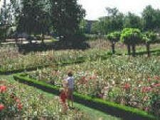 Peninsula Park is a formally designed neighborhood park, typical of the early 1900s. It includes the city's first public rose garden and first community center, an historically designated bandstand, and Portland's second oldest playground.
The rose garden, designed by Emanuel L. Mische, is one of Portland's most beautiful formal rose gardens, with 8,900 plantings on a two-acre site. The garden entrance is located on Albina Ave, between Ainsworth and Rosa Parks Way. Visitors are greeted by magnificent plantings of 65 rose varieties which border the steps leading to the sunken rose garden, the only one in Oregon. The rose garden was the showplace of its time, with 300,000 visitors in the first year alone. The official Portland rose, named Mme. Caroline Testout, was cultivated in the garden. Once planted by the thousands along the streets of Portland, this rose earned Portland the name 'City of Roses.' In 1913, floral enthusiasts selected Peninsula Park as the location for an annual rose show. In 1917, Washington Park on Portland’s west side was selected as the site of the International Rose Test Garden and most of the rose show activities were moved there.
In 1957, the city zoo housed its Humboldt penguins in the center's pool for six months because the zoo lacked the proper facilities when the birds arrived from Antarctica. Many Portlanders still remember calling it Penguin Park!
The 16 plus acre park includes a basketball court, disabled access picnic area, disabled access restroom, fountain, horseshoe pit, paths, picnic site with picnic tables, playground, public garden, rose garden, soccer field, softball field, lighted tennis court, and wedding site.
View a video of the park with pleasant music.
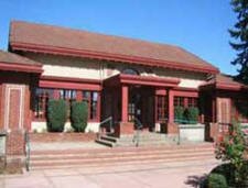 The Peninsula Community Center and Pool was built in 1913 and the Italian-villa style facility was the first community center in the Portland park system. Its original floor plan was perfectly symmetrical, consisting of two pools and two gyms − one for men, the other for women. Such separate-but-equal social attitudes were also reflected in the entryway murals: young men featured in the area leading to the men's side, and young women on the women's side!
The Peninsula Pool was built in order to fill the need created by the closure of the bath houses that had been in use on the Willamette River. These structures were closed due to increasing pollution in the Willamette. As popular as the pool is with people, it also has a history of being enjoyed by Humboldt penguins. In 1957, when the penguins were scheduled to make their debut at the Washington Park Zoo, the zoo's penguin facilities were not yet finished, so the Peninsula Park Pool was used as a holding area until their own space was ready.
The center includes a basketball court, gymnasium, meeting room, party room, and outdoor swimming pool.
Farragut Park 16-acres includes a basketball court, disabled access play area, disabled access restroom, paths, picnic tables, playground, and softball field.
Walking in the Piedmont Neighborhood
This Peninsula Park and four neighborhoods 2.6 mile walk begins at the Multnomah County library and passes through Piedmont before heading back along Interstate Avenue. Click here to download the guide. Another walk (2.5 mile) in the neighborhood offers these points of discovery: Peninsula Park sunken rose garden, the North Portland Library, Portland Community College Cascade Campus, a new urban village, Portland Boulevard and N Killingsworth MAX Stations, a community art installation and the pedestrian bridge that conveniently crosses I-5 with a connection to the MAX light-rail line. Click here to download the guide.
Walk Score helps you find a walkable place to live. Walk Score is a number between 0 and 100 that measures the walkability of any address. Portland is the 12th most walkable city in the U.S. with a Walk Score of 66 and 57% of the residents have a Walk Score of 70 or above.
The Piedmont neighborhood ranks 43 out of 89 Portland neighborhoods. Below is a Walk Score for an address in the center of the neighborhood.
More About Piedmont
- Neighborhood Association Web site Piedmont Neighborhood Association.
- Neighborhood Location About three miles north of downtown Portland just to the east of I-5.
- Topography The topography is flat with mature trees.
- Sidewalks and Streets The street pattern is a grid layout. The neighborhood has sidewalks for walking.
- Livability Study 86.5% of Piedmont residents rated their neighborhood "good" or "very good." See Livability Study.
- 1Drive Time to Downtown Piedmont is 12-14 minutes from downtown.
- Public Transportation There are bus routes on NEt Martin Luther King Jr. Boulevard, Portland Boulevard, Lombard Street and North Albina Avenue for a total number of five routes. The Interstate MAX light rail nearest stops are on North Interstate Avenue (at North Lombard Street) and at North Portland Boulevard. These stops are just a few blocks west of Piedmont's boundary and within walking distance for many residents of Piedmont. The downside is that you have to cross I-5 to get to the MAX. Transit Score provides a 0-100 rating indicating how well an address is served by public transportation. Ratings range from "Rider's Paradises" to areas with limited or no nearby public transportation.
- 2Census 2010 Demographics Population: 7,025 persons. Area in acres: 615. Average population density: 11 persons per acre. Number of households: 2,983. Average size of household: 2.36 persons. Median household income: $37,772. Families with children: 19.1%. Home owners: 64.2%. Renters: 35.8%. Diversity: 34.8% non-Caucasian. More census data about Piedmont at Portland Online.
- 3Crime Stats 15 violent crimes and 35 total crimes per 1,000 residents in 2011. There were 36 violent crimes in 2010 and total crimes per 1,000 residents was 30.
- 4Shopping and Services Number of supermarkets: 0. Number of health clubs: 0. Number of coffee shops: 0. Most Piedmont residents head west (cross I-5) and shop along N. Interstate Avenue where there are two supermarkets and numerous stores and restaurants.
- Eating Out Very limited within Piedmont. More on the east border (Martin Luther King Jr. Blvd.). Try Betty Jean's at 825 North Killingsworth Street. BJ is actually located just a few blocks south of North Ainsworth Street in the Humboldt neighborhood. Betty Jean's specializes in hamburgers and spicy, curly fries with that "down home taste". Lots of kids seats. Visit Willamette Weeks' Restaurant Guide by Neighborhood for a review of eating places in Piedmont.
- Public Library The closest branch library of the Multnomah County Library system is the North Portland at 512 N. Killingsworth Street. This is just 3-4 blocks south of the neighborhood.
- Who Lives in Piedmont A mix of blue collar and white collar. The median age is 36.7 according to Census 2010.
- What They Drive in Piedmont GMC and Ford - sedans, pickups and a few SUVs.
- Biking Quality is fair. Piedmont has eight miles of bike lanes. Bicycle Trip Planner will map a route for you and − just provide a starting point address and your destination address.
- Schools Elementary: Applegate Elementary. Middle school: Ockley Green Middle School. High school: Jefferson High School. Holy Redeemer Catholic School (K-8) is located in the neighborhood. Telephone (503) 283-5197.
- School Report Card Grades Elementary schools: S. Middle school: S. High School: I. Click here for report card details.
Map of the Piedmont Neighborhood
Fly to the Piedmont Neighborhood via Google Earth
Coordinates
45° 33′ 02.90″ N
122° 40′ 27.05″ W
Launch Google Earth
___________________________________
1Real Estate Values Data on real estate values provided by RMLStm. Distressed properties refer to the percentage of total homes sold that were short sales and bank-owned properties.
2Drive Time to Downtown Estimated commuting time obtained from Yahoo Maps and Google Maps. Drive time was calculated from a central intersection in each neighborhood to Pioneer Courthouse Square during the morning peak commute time.
3Demographics Data Numbers were obtained from Census 2010 and www.portlandmaps.com.
4Crime Statistics Numbers on crime were obtained from Portland Police Bureau. Violent crimes are defined as murder, rape, robbery, and aggravated assault. Crimes per 1,000 are based on reported incidents of violent crime, as well as burglary, larceny, and motor vehicle theft.
5Shopping and Services Numbers were determined from local directory listings and county/municipal library systems.
6Biking Quality rating based on the 2007 Cycle Zone Analysis conducted by the City of Portland Office of Transportation. The six-tier ratings have been reduced to three levels: High, Fair, and Low.
7School Report Card Grades Schools ratings from the Oregon Department of Education 2009-2010 performance assessment. "O" = Outstanding; "S" = Satisfactory; "I" = In Need of Improvement; NR = Not Rated.
|
Piedmont
|
Piedmont Boundaries
West - Interstate 5
|
To learn more about the
|
Learn More
|
Guide to the University Park Neighborhood in Portland, Oregon

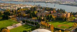
The neighborhood is home to the University of Portland, a private catholic college. The school is noted for its powerful women's soccer team that are always ranked among the top teams in the nation. Although the campus, sitting on the south side of the neighborhood overlooking the river, is attractive and serene the area is most definitely not a "college neighborhood." Where are the pubs, coffee shops, and other student related businesses? The problem is that there's no town center where people can congregate and walk. Instead you have to drive from establishment to establishment.
The northern border of University Park is the high traffic (mainly trucks) Lombard Street. Lombard is the the main road through North Portland between I-5 and the St. Johns neighborhood. Along the road you will see paycheck cashing outlets and bars along with fast food restaurants with a few other businesses. The Java Bean, 4823 N. Lombard Street, is the place to stop for a latte, pastry and a chat.
University Park has seen an influx of new residents to the area as the housing prices are low enough to attract first-time buyers who are ambitious about remodeling their homes. So University Park now has some areas with improved homes and neighborhoods and some still in transition. Most homes were built after WWII (no defining style). University Park has a handful of classic homes and those are mainly Queen Ann Victorians and Colonials. Most of the homes are on small lots. Surprisingly, there are no apartment houses as the University of Portland students all live on campus or in homes.
History
Three groups of interesting street names in north Portland are survivors of an attempt by the Methodist Church to establish a university here. It was located on Waud's Bluff, where the University of Portland is today. The Methodists' institution, called Portland University, opened in 1891. Because of financial difficulties, it lasted for less than a decade. Subsequently, the campus and buildings were purchased by the Roman Catholic Archdiocese, and the facilities re-opened in 1901 as Columbia University, with a faculty of priests from the Order of Holy Cross. In 1935, it was renamed University of Portland.
 Surrounding the original Methodists' University, and conceived as its financial base, was a large real estate development. The names which the Methodists assigned to the streets in their "University Park" subdivision were enduring. Nineteen of those street names are compliments to American colleges and universities (Amherst, Berkeley, Harvard, Oberlin, Stanford, Yale, etc.). Another 18 streets were named to honor educators, theologians, and authors who were prominent in the nineteenth century (Dana, Hurst, Kimball, Olin, Wayland, Winchell, etc.). Fourteen names commemorate Methodist bishops, ministers, prominent laymen, and places important in Methodist history. The 51 streets are within about half a mile of the University of Portland.
The Methodists founded two other colleges in Oregon: Willamette University and Corvallis College (now Oregon State University).
The University Park neighborhood Web site has more information about the history of the area.
Sun for Everyone
When the Methodists accumulated 600 acres around the present-day University of Portland in early 1891, the trustees set aside 71 acres for the university campus. The rest of the tract − about 500 city blocks − was platted into residential building lots. It was in making the plat maps for these subdivisions that the Methodists had the pleasure of selecting the street names listed above. An interesting feature in part of the development was this: the streets were laid out running northeast-to-southwest and northwest-to-southeast, so that, if a house were placed squarely on its lot, every side of the house would, at some time during the day, have the sun upon it.
Origin of Name
University Park is so named because the neighborhood surrounds the University of Portland. It actually was named for the Methodist college called Portland University.
1University Park Home Prices
- Number of Homes Sold in University Park—► 67 homes sold in 2011 and 13% were distressed sales. 64 homes sold in 2010 and 19% distressed properties sales were 19%.
- Average Price for Homes Sold in University Park—► $271,525 in 2011.
- Median Price for Homes Sold in University Park—► $280,000 in 2011, $256,500 in 2010, $262,300 in 2009, and $280,500 in 2008.
- 1-Year Median Sales Price Change in University Park—► 2011 the sales price change was 14%. 2010 the change was -2%.
- 5-Year Average Sales Price Change in University Park—► 2007 to 2011 the sales price change was -1%. 2006 to 2010 the change was -5%.
- Portland Metro Area Median Home Price—► $221,000 in 2011, $239,900 in 2010, $247,000 in 2009, $278,000 in 2008, and $290,000 in 2007.
- Portland Metro Area Average Home Price—► $263,300 in 2011, $282,100 in 2010, $289,900 in 2009, $330,300 in 2008, and $342,000 in 2007.
Please be aware that the above figures are subject to error and are intended as guidelines only.
University Park Homes for Sale
Parks and Health Clubs
 One of the crown jewels of the Portland Park system is the 35-acre Columbia Park located in the both the University Park and Portsmouth neighborhoods. The park includes baseball, softball, and soccer fields, two lighted tennis courts, volleyball court, horseshoe pit, swimming indoor pool, wading pool, playground, picnic shelter, and tables, electricity, restrooms, trails, and parking lot. This park has been "adopted" by the Friends of Columbia Park. For information about renting Columbia Cottage, go to www.focp.org.
Although the city has a placeholder on its Web site about a park called Harbor View City Park, it is an old industrial site along the river full of trash and perhaps some day they will either make a park out of it or it will be developed.
The neighborhood has two other parks:
- McKenna Park The 4.5 acre park includes a basketball court, paths, picnic tables, playground, soccer field, and softball field.
- Portsmouth Park The four acre park includes a playground, soccer field, and softball field.
Walking in the University Park Neighborhood
Walk Score helps you find a walkable place to live. Walk Score is a number between 0 and 100 that measures the walkability of any address. Portland is the 12th most walkable city in the U.S. with a Walk Score of 66 and 57% of the residents have a Walk Score of 70 or above.
The University Park neighborhood ranks 76 out of 89 Portland neighborhoods. Below is a Walk Score for an address in the center of the neighborhood.
More About University Park
- University Park Neighborhood Association Web site University Park.
- Neighborhood Location The west boundary is along the Willamette River about 3-4 miles north of downtown.
- 1Drive Time to Downtown 18-20 minutes.
- Topography University Park seats on a bluff overlooking Swan Island and Columbia River. The topography is flat with mature trees on most properties.
- Sidewalks and Streets The street pattern is a grid layout. The neighborhood has sidewalks for walking.
- Livability Study 86.8% of University Park residents rated their neighborhood "good" or "very good." See Livability Study.
- Public Transportation The schedule can be found at TriMet Web site for the three neighborhood bus routes. The Interstate MAX light rail line is about a mile from the heart of University Park to a stop (Portland Boulevard). Transit Score provides a 0-100 rating indicating how well an address is served by public transportation. Ratings range from "Rider's Paradises" to areas with limited or no nearby public transportation.
- 2Census 2010 Demographics Population: 6,035 persons. Area: 798 acres. Average population density: 7 persons per acre. Number of households: 1,834. Average size of household: 3.29 persons. Median household income: $51,413. Families with children: 20.2%. Home owners: 64.1%. Renters: 35.9%. Diversity: 16% non-Caucasian. More census data about University Park at Portland Online.
- 3Crime Stats 17 violent crimes in 2011 and 35 total crimes per 1,000 residents. 13 violent crimes in 2010 and total crimes per 1,000 residents was 46.
- 4Shopping and Services Number of supermarkets: 1. Number of health clubs: 0. Number of coffee shops: 0. North Lombard Street is the main street and it has a bit of everything from fast food outlets to a couple of coffee shops and taverns. A Fred Meyer supermarket is located at North Interstate Avenue and North Lombard. Portland based New Seasons Market is located on N. Interstate and N. Portland Boulevard. Traveling west on Lombard, you will not be impressed with the quality of the commercial area. East is a different story as the MAX light rail has changed the character of this commercial area along N. Interstate Avenue − you will now find banks, fast food outlets, restaurants, coffee shops, etc.
- Eating Out North Lombard Street is the main street and it has a bit of everything from fast food outlets to a couple of coffee shops and taverns. There are a few restaurants along Lombard but we cannot attest to the quality of the food or service as we have never ventured into one of them. Your best bet for a meal is to try some of the restaurants along N. Interstate such as Fire on the Mountain (buffalo wings). Visit Willamette Weeks' Restaurant Guide by Neighborhood for a review of eating places in University Park.
- Public Library The closest branch library of the Multnomah County Library system is the St. Johns at 7510 N. Charleston Avenue.
- Who Lives in University Park University staff and students, professionals who commute to downtown Portland, and industrial workers because of the close proximity to the Northwest Industrial area. The median age is 23.6 according to Census 2010.
- What They Drive in University Park Modest vehicles to include a few SUVs and pickups.
- Biking Quality is fair. University Park has five miles of bike lanes. Bicycle Trip Planner will map a route for you and − just provide a starting point address and your destination address.
- Schools Elementary school: Astor Elementary. Middle school: Portsmouth. High school: Roosevelt High School.
- School Report Cards Elementary schools: O/S Middle schools: NA. High school: O/I. Click here for report card details.
Map of the University Park Neighborhood
Fly to the University Park Neighborhood via Google Earth
Coordinates
45° 34′ 35.27″ N
122° 43′ 46.53″ W
Launch Google Earth
___________________________________
1Real Estate Values Data on real estate values provided by RMLStm. Distressed properties refer to the percentage of total homes sold that were short sales and bank-owned properties.
2Drive Time to Downtown Estimated commuting time obtained from Yahoo Maps and Google Maps. Drive time was calculated from a central intersection in each neighborhood to Pioneer Courthouse Square during the morning peak commute time.
3Demographics Data Numbers were obtained from Census 2000 and www.portlandmaps.com.
4Crime Statistics Numbers on crime were obtained from Portland Police Bureau. Violent crimes are defined as murder, rape, robbery, and aggravated assault. Crimes per 1,000 are based on reported incidents of violent crime, as well as burglary, larceny, and motor vehicle theft.
5Shopping and Services Numbers were determined from local directory listings and county/municipal library systems.
6Biking Quality rating based on the 2007 Cycle Zone Analysis conducted by the City of Portland Office of Transportation. The six-tier ratings have been reduced to three levels: High, Fair, and Low.
7School Report Card Grades Schools ratings from the Oregon Department of Education 2009-2010 performance assessment. "O" = Outstanding; "S" = Satisfactory; "I" = In Need of Improvement; NR = Not Rated.
|
View
|
University Park
|
To learn more about the
|
Learn More
|