| Subscribe to the Moving to Portland Newsletter |
35°F
Guide to the City of Beaverton, Oregon |
|
Two events in the 90s turned this sleepy suburb into a sprawling city:
In Beaverton, one-fourth of residents grew up without English and one-fifth are foreign-born. Beaverton defies everything we've been taught about suburbs and cities. It is more diverse, more dynamic and more densely populated (4,795 people per square mile vs. 4,375 people per square mile) than Portland, yet it doesn't look at all like a city. Here is what The Oregonian had to say about Beaverton in an article: Our presumptions about Beaverton -- that it is white, affluent and tranquil -- began after World War II, when a sudden influx of working-class and mixed-race populations into Portland led the city's real estate concerns to extol the virtues of a brand-new opportunity: "Southwest Suburbia," as The Oregonian called it in one of many circulars announcing this promised land. Beaverton, the Portland papers told us in the late 1950s, would provide a new refuge for those who could afford to move: " 'Over the hill,' into the Tualatin Valley was attractive even a century ago to pioneers retreating from the bustle of a growing waterfront city. There was room for fields and orchards, where wood was readily available, and the sunsets over the coast range beautiful." In the mythology of the suburbs, a second wave of pioneers — the new suburbanites — moved farther west to escape the rabble and find redemptive quiet on Beaverton's untenanted lands. Downtown BeavertonThe area just west of Highway 217 along Canyon Road and the Beaverton-Hillsdale Highway was the heart of old downtown. Finding the original downtown is almost impossible because for blocks (more accurately miles) around the area, one-story retail outlets have sprung up. Car dealerships combined with numerous mini-malls has erased any sign of historic Beaverton. The Cedar Hills Mall (just north of old downtown) and the area around old downtown have melted together so it is almost impossible to tell where one starts and the other begins. But for all the complaints about the landscape of the area, it attracts shoppers. Within a mile one can buy a new automobile, scout out the latest in electronics equipment, shop for the week's supply of food, complete one's wardrobe, and have lunch at any fast food outfit. Of course you can also attend a movie and sip a latte. History of BeavertonThe Tualatin Valley and Beaverton area was originally the home of native people who referred to themselves as "Atfalati". Westerners later mispronounced the name as Tualatin. The tribe was a hunter-gatherer group which relied more on plants than animals for their food. In the spring of 1847, the first land claim (comprising 640 acres of beaverdam) located in what is now Beaverton was taken up by Lawrence Hall. Lawrence and his brother built a grist mill near present-day Walker Road. Spurred on by a railroad into town built in 1868, the small farming community west of Portland began to grow. By 1893 the City of Beaverton was formally incorporated with a population of 400. Beaverton May Grow to 300,000 Within Ten Years
Working under state law, Washington County is in the process of transferring its urban neighborhoods and the services they require to the control of cities. City and county leaders set no timeline for these final annexations that would fill out the city. Using the current populations of those areas, Beaverton would add about 200,000 residents. The first round of annexations focuses mostly on areas already surrounded by the city. State law allows those annexations without landowner approval. The second round may require more input for landowners who currently are outside city limits and farther from current boundaries. Beaverton's ultimate boundary would extend at least to Northwest Springville Road and the Multnomah County line to the north, the city of Portland to the east and the city of Tigard to the south. The boundary would follow the Beaverton School District line to the west. One obstacle will be the opposition of Nike. In a prepared statement, Nike officials said that they have taken legal steps to block the city from incorporating its headquarters. It is expected that several other groups will begin mounting opposition to the annexation plans. For properties the city has recently annexed, property taxes increase to $2.72 for each $1,000 of assessed value. That means a $544-a-year increase for the owner of a house with an assessed value of $200,000. Portland Monthly Magazine Neighborhood Guide
To help those in the housing market, the magazine combines all the data from about 120 neighborhoods and communities in the Portland metro area. Include in the document are housing prices, school ratings, demographics, crime statistics, parks, commuting information, and services. Click here to view the report. Beaverton Civic PlanOver the past several years, more than 5,000 residents crafted the Beaverton Community Vision which emphasizes greater connectivity, economic opportunity, and environmental sustainability. The Beaverton Community Vision reflects goals and ideas shaped by the people of Beaverton, and without testing and prioritizing these ideas and developing a coordinated plan, the vision’s boldest ideas will remain concepts and “might-have-beens.” The Civic Plan is the City’s commitment to making many of the aspirations of the Community Vision a reality and will unite the City behind an effort to achieve vision goals and priorities. Now is the time to assemble the resources, tools, and partnerships to bring that vision into action. This work will require many hands and won’t be done overnight. While the Community Vision set the roots, the Civic Plan will provide a framework to bear the fruits of your community vision Beaverton is the Home of Nike
In the mid 90s, the city attempted to forcibly annex Nike's headquarters, which led to a lawsuit by Nike, and lobbying by the company that ultimately ended in with a bill passed by the Oregon Legislature in 2005. Under that bill's terms, Beaverton is specifically barred from forcibly annexing the land that Nike and Columbia Sportswear occupy in Washington County for 35 years. Beaverton is also the home of Tektronics, a high tech firm and one of Oregon's largest employers. Tualatin Hills Park and Recreation DistrictBeyond the asphalt auto lots of Canyon Road, miles of trails zigzag through forest groves and quiet parks. You won't need a car here. Sixty miles of trails link Beaverton schools, recreation centers, playgrounds, restaurants and shops to nature. Hidden behind suburban strip malls, the paths curve around neighborhood streets, wetlands and dense blackberry thickets. The Tualatin Hills Park and Recreation District encompassing Beaverton serves approximately 200,000 residents in Washington County. It provides 200 parks spread over 1,300 acres with 30 miles of hiking trails and a 25-mile bike path network. Two "must see" trail destinations include the 219-acre Tualatin Hills Nature Park and historic Jenkins Estate on Cooper Mountain. The features of the district include three recreation centers, a sport complex, a regional nature park, eight swim centers, a tennis center, two historic sites, a senior center, skate park, roller hockey park, and two lakes. The district sponsors recreational and competitive league sports and special-interest classes. Beaverton NeighborhoodsIt's difficult to get your "arms around" Beaverton because it really is numerous villages within a city. Currently, the City of Beaverton 11 recognized Neighborhood Association Committees (NACs). Participation in a NAC is open to anyone who lives, works, owns a business, or represents an institution or non-profit organization within the boundaries of the NAC. For maps (PDF format) of the neighborhoods, visit Beaverton Neighborhood. Following are the neighborhoods Web pages:
Community Demographics and Web Sites
More About Beaverton
5Beaverton Home Prices
Search for Homes in Beaverton
Below you can see SpatialMatch's map displaying homes currently for sale in Beaverton.
______________________________________
1Drive Time to Downtown Estimated commuting time obtained from Yahoo Maps and Google Maps. Drive time was calculated from a central intersection in each neighborhood to Pioneer Courthouse Square during the morning peak commute time.
|
 Beaverton is the fifth largest city in Oregon with a population of 89,803 (2010 US Census) and a land area of 18.73 square miles. Beaverton is located in Washington County which is one of the fastest developing areas in Oregon with a population of 529,710 in 2010 (the populationt was 445,342 in 2000). That represents an increase of 16% from 2000. Washington County grew 42.94% from 1990 to 2000.
 In December 2004, the City of Beaverton announced that they would annex the unincorporated neighborhoods of Cedar Hills, West Slope, Raleigh Hills and Garden Home over the next 10 years. It also would add the Nike and Tektronix campuses and Providence St. Vincent Medical Center. After a first round of annexations, the city would add the Bethany and Cedar Mill areas and much of Aloha.
 The
The  Nike's 750-acre campus is located in the heart of Beaverton where sports celebrities come and go frequently. Nike's world headquarters are surrounded by the city of Beaverton, but are within unincorporated
 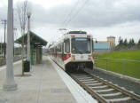 Public Transportation Beaverton has two transit lines and 20 bus routes.
  To search for homes in Beaverton, go to