Guide to the Forest Park Neighborhood in Portland, Oregon
Forest Park is a neighborhood on the northwestern edge of Portland; it combines rolling green pastures, views east, and west, and under a 20-minute drive to downtown. Built along a ridge northwest of downtown and only 10-15 minutes from the attractions of the Northwest District. It is commonly referred to as the “Intel Country Club” because so many of the Intel engineers who work in Hillsboro live in Forest Heights.
The Forest Park neighborhood residents have easy access to the City of Portland’s 5,000 plus acre Forest Park, the southern portion and eastern of which lies within the neighborhood boundaries and the rest of which is adjacent. Most of the neighborhood lies within unincorporated Multnomah County, though it does include some areas within Portland city limits. It’s bordered by the Northwest Heights, Hillside, Northwest District and Linnton neighborhoods.
View a map of the Forest Park neighborhood.
Forest Park is a great place to bring up a family as some of the best schools in Oregon are located in the neighborhood. For example, the Forest Park Elementary has been rated “exceptional” since 2004. See the latest State of Oregon Department of Education Report Cards.
Origin of the Name Forest Park
The neighborhood is located adjacent to the 5,000 plus acre City of Portland Forest Park.
Schools in the Forest Park Neighborhood
Find your school attendance area or a school site and view the boundary area using School Locator. Read how to use the interactive map by clicking on the “Information” icon (circle with an “i” in the center).
- Schools in the Neighborhood A list of public and private schools in the Forest Park neighborhood.
- Public Schools in the Neighborhood Elementary schools: Forest Park. Middle school: East-West Sylvan. High school: Lincoln High School.
- School Report Cards Report Cards for schools and districts in Oregon. Select “Portland SD 1J” to view individual schools within the Portland Public School District.
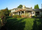
Forest Park Home Styles
Diversity in homes styles and sizes are the attraction. Townhomes under 2,000 square foot to 3,000 plus square foot detached single-family homes are found in Forest Park. Most have been constructed in the last ten years, and the area is still being developed. Many of the homes have views of the coast range to the West and are within walking distance of the 5,127 acre Forest Park which is on the east side of the elongated neighborhood (about 5 miles in length).
Portland Monthly Magazine Guide to Neighborhoods
 In their April issue every year, the Portland Monthly Magazine features the past year home prices along with other information about Portland neighborhoods and suburban communities. To read the magazine’s latest stories and numbers visit the Real Estate section.
The numbers on the website and the printed magazine are divided into four sections (real estate, people, crime, and lifestyle) on each of the Portland 90 plus neighborhoods as well as about 25 suburban communities. The website offers over 50 items of information about each Portland neighborhood and suburban community.
The magazine added a feature on their website for homes sold in 2014 and it’s also available for homes sold in 2015 — an interactive map where you can click on a neighborhood and a pop-up displays five items (1-year median price change, 5-year median price change, median gross rent, walkability score and percent of newcomer) for a Portland neighborhood as well as a suburban community. Note the detailed numbers for each of the four sections for homes sold in 2015 are displayed below the map.
To visit the magazine’s website latest stories and numbers visit their Real Estate section — click on “Neighborhoods” to view the numbers for the Portland neighborhoods and click on “Suburbs” for the numbers on communities in the metro area. Note the detailed numbers for each of the four sections for homes sold in 2014 and 2015 are displayed below the map. To access the Portland neighborhoods and metro communities demographic data and home prices by year:
- 2014 Demographics and Home Prices
- 2015 Demographics and Home Prices
- 2016 Demographics and Home Prices
Forest Park Demographics Below are some facts about the Forest Park neighborhood gleaned from the magazine’s website. A few numbers can tell much about the character of a neighborhood. You can view more data about Forest Park by visiting the Portland Monthly’s website.
- Average year homes built in the neighborhood: 1992
- Percent of residents below poverty level: 7.3%
- Percent of neighborhood size with parks: 73%
- Live within a 1/2 mile of a park: 43%
- Commute by bike or walking: 3.6%
1Forest Park Home Prices: 2007-2015
- Number of Homes Sold in Forest Park—► 28 homes were sold in 2016 and 7% were distressed property sales. 61 homes were sold in 2015 and 3.3% were distressed property sales. 30 homes were sold in 2014 and 3% were distressed property sales. 18 homes were sold in 2013 and 11% were distressed sales. 15 homes sold in 2012 and 13% were distressed sales. 21 homes sold in 2011 and 10% were distressed sales. 17 homes sold in 2010 and 24% were distressed properties sales.
- Median Price for Homes Sold in Forest Park—► $839,500 in 2016, $723,220 in 2015, $751,000 in 2014, $678,500 in 2013, $608,000 in 2012, $570,000 in 2011, $600,000 in 2010, $610,000 in 2009, $655,000 in 2008, and $762,500 in 2007.
- Average Cost per Square Foot—► $226 in 2016, $227 in 2015, $219 in 2014.
- 1-Year Median Sales Price Change in Forest Park—► 2016 the change was 3%. 2015 the change was -3.7%. 2014 the change was 11%. 2013 the change was 12%. 2012 the sales price change was 7%. 2011 the sales price change was -5%. 2010 the sales price change was -2%.
- 5-Year Median Sales Price Change in Forest Park—► 2012 to 2016 the sales price change was 41%. 2011 to 2015 the sales price change was 27%. 2010 to 2014 the sales price change was -6%. 2009 to 2013 the sales price change was -15%. 2008 to 2012 the sales price change was -24%. 2007 to 2011 the sales price change was -32%. 2006 to 2010 the sales price change was -29%.
- Portland Metro Area Median Home Price—► $395,000 in 2016, $308,000 in 2015, $285,500 in 2014, $265,000 in $235,000 in 2012, $221,000 in 2011, $239,900 in 2010, $247,000 in 2009, $278,000 in 2008, and $290,000 in 2007.
- Portland Metro Area Average Home Price—► $347,000 in 2016, $354,500 in 2015, $333,000 in 2014, $310,600 in $275,000 in 2012, $263,300 in 2011, $282,100 in 2010. $289,900 in 2009. $330,300 in 2008, and $342,000 in 2007.
Please be aware that the above figures are subject to error and are intended as guidelines only.
Find a Home in Forest Park
- Homes for Sale in the Forest Park Neighborhood — View on all devices except Apple® mobile devices. To view homes for sale in Forest Park on Apple® mobile devices key in “Forest Park” in the “Location” field and click on the “Search Now” icon.
- Displays Homes for Sale in the Forest Park Neighborhood — View on all devices. Photos of home displayed along with detailed description of the property.
- Search for Homes — Search on all devices. Map-based on devices configured with Adobe Flash and Javascript and text-based on any device.
Homes for Sale in Forest Park
14125 Nw Germantown Rd Portland, OR 97231

448 Nw Skyline Blvd Portland, OR 97229

9936 Nw Wind Ridge Dr Portland, OR 97229

429 Nw Skyline Blvd Portland, OR 97229

7307 Nw Penridge Rd Portland, OR 97229

7338 Nw Penridge Rd Portland, OR 97229

875 Nw Skyline Blvd Portland, OR 97229

10690 Nw Laidlaw Rd Portland, OR 97229

12222 Nw Old Germantown Rd Portland, OR 97231

9522 Nw Skyview Dr Portland, OR 97231

7240 Nw Summitview Dr Portland, OR 97229

15115 Nw Red Cedar Ct Portland, OR 97231

13106 Nw Germantown Rd Portland, OR 97231

376 Nw 81st Pl Portland, OR 97229

9428 Nw Skyview Dr Portland, OR 97231

7430 Nw Penridge Rd Portland, OR 97229

224 Nw Skyline Blvd Portland, OR 97210

5929 Nw Skyline Blvd Portland, OR 97229

14409 Nw Mactavish Ln Portland, OR 97231

16840 Nw Crossvine St Portland, OR 97229

10971 Nw Brooks Rd Portland, OR 97231

290 Nw Royal Blvd Portland, OR 97210

11703 Nw Old Cornelius Pass Rd Portland, OR 97231

8313 Nw Skyline Blvd Portland, OR 97229

322 Nw 83rd Pl Portland, OR 97229

11325 Nw Laidlaw Rd Portland, OR 97229

10573 Nw Skyline Blvd Portland, OR 97231

495 Nw Greenleaf Rd Portland, OR 97229

10575 Nw Skyline Blvd Portland, OR 97231

10605 Nw Skyline Blvd Portland, OR 97231

5750 Nw Cornell Rd Portland, OR 97210

11432 Nw East Rd Portland, OR 97229

3096 Nw Parkhurst Ter Portland, OR 97229

10061 Nw Skyline Blvd Portland, OR 97231

12525 Nw Germantown Rd Portland, OR 97231

7959 Nw Royalfern Pl Portland, OR 97229

427 Nw Skyline Blvd Portland, OR 97229

9245 Nw Skyline Blvd Portland, OR 97231

9301 Nw Skyline Blvd Portland, OR 97231

7943 Nw Royalfern Pl Portland, OR 97229

5945 Nw Saltzman Rd Portland, OR 97210

Walking in Forest Park: 70 Miles of Trails

Portland’s Forest Park is the 14th largest city park in the United States and the only urban wilderness park in the country. Covering 5,000 plus acres, it provides a hushed and peaceful environment of a varied and evolving forest ecosystem. Overlooking the Willamette River, the Park stretches for nearly eight miles along the northeast slope of the Tualatin Mountains between NW Skyline Boulevard and NW St. Helens Road (Hwy. 30). Most Portlanders today don’t know it, but our largest city park wasn’t supposed to be named Forest Park. Only because a quorum wasn’t available on the evening of September 12, 1957, when the “official name” was to be designated, did it arise by default. The preferred moniker was “Tualatin Mountain.”
Forest Park is home to over 100 species of mammals and more than 100 kinds of birds have been seen in the Park. In the spring, hillsides sparkle with trilliums amidst the sword ferns; hundreds of other kinds of flowers and shrubs bloom during the year.
The Park offers enjoyment to hikers, bicyclists, runners, and others who just enjoy being outdoors in a forest atmosphere. The 30+ mile long Wildwood Trail (a National Recreational Trail) traverses the Park from the Vietnam Veterans’ Memorial in Hoyt Arboretum to Newberry Road. A total of more than 70 miles of interconnecting trails and lanes provide opportunities for circle hikes of varying length.
Forest Park has about 5,100 acres of parkland and open spaces according to Metro and the Portland Department of Parks and Recreation. Much of the wooded city park (Forest Park) is part of the neighborhood.
A Father and His Son Hike Forest Park
Miles of trails serve bikers, hikers, and casual strollers. One of the most popular hikes is the portion of the Leif Erikson trail that begins at the end of NW Thurman Street. A wide, leafy fire trail with a gradual uphill grade, you can bike or walk the trail. It’s also a popular place for runners.
See the Friends of Forest Park website for more information. Forest Park is on Facebook.
Walk Score helps you find a walkable place to live. Walk Score is a number between 0 and 100 that measures the walkability of any address. Portland is the 14th most walkable city in the U.S. with a Walk Score of 63, a Transit Score of 50 and a Bike Score of 72. There are over 3,000 restaurants and coffee shops in Portland. People in Portland can walk to an average of five restaurants and coffee shops in five minutes. The Forest Park/Linnton neighborhood is very car-dependent and Walk Score gives it a zero rating.
More About Forest Park
Learn more about the Forest Park neighborhood by visiting Portland Maps. The site provides a list of businesses, demographic data, crime stats, parks, schools, aerial photos, maps, elevation, hazards, and more for the Forest Park neighborhood. All you need is a property address – use “350 NW Royal Blvd.” or an address of your choice.
- Neighborhood Association Website Forest Park Neighborhood.
- Location of Neighborhood It rests on the west side of Forest Park between NW Barnes on the south, Newberry Road on the north and the Washington County line on the west.
- Boundaries of Forest Park The boundaries of this 6,996 acre neighborhood can best be described as that area to the west of the 5,127 acre Portland Forest Park. The neighborhood is between NW Barnes on the south, Newberry Road on the north and the Washington County line on the west.
- Map of Forest Park Boundaries Forest Park.
- 2Drive Time to Downtown 18-19 minutes.
- Topography Moderate to very hilly. It is a heavily wooded area and many homes have views of the Coastal Mountain Range.
- Streets and Sidewalks Void of sidewalks except along Miller Road in Forest Heights. The streets leading to the developments can be winding and narrow.
- Public Transportation Forest Park has four bus lines — visit the TriMet website. No MAX light rail or streetcar lines in Forest Park. Transit Score provides a 0-100 rating indicating how well an address is served by public transportation. Ratings range from “Rider’s Paradises” to areas with limited or no nearby public transportation.
- Commuting 2.4% of the neighborhood residents commute using public transportation, 2.2% bike and 1% walk.
- 3Census 2010 Demographics Population: 3,081 people. Area (acres): 11,961. Average population density: 0.35 per acre. Number of households: 1,611. Average household size: 2.41. Median income of household: $112,666. Homeowners: 82%. Renters: 18%. Diversity: 14.3% non-Caucasian. More census data about Forest Park at Portland Online and City Data.
- 4Crime Stats There were 73 property crimes (assault, arson, burglary, larceny, robbery, theft from auto, vehicle theft) in 2014. There was one violent crime (aggravated assault, homicide, robbery, rape) committed in 2014. There were 17 crimes per 1,000 residents in 2014. For the latest crime statistics and historical data for Portland neighborhoods, visit the Portland Police Bureau website.
- Sex Offenders Click here for the State of Oregon Sex Offender Inquiry System. After agreeing to the “Conditions of Use Statement,” you will be redirected to a “Enter Search Criteria” page. Insert a zip code in the “Zip” field and click on the “Query” button. Forest Park zip code(s): 97210, 97229, 97231.
- 5Shopping and Services These neighborhood is void of any retail establishments but it is a short drive to a small mall (corner of SW Barnes Road and NW Miller Road) with a QFC supermarket, Starbucks, cleaners, pizza, vet, etc. Residents are about 10-15 minutes from the Northwest District as well as a larger mall just off NW Cornell Road. In Forest Heights (southwest of the neighborhood), the area’s first commercial site is been developed at NW Miller Road and NW Mill Ridge. It has a grocer and Starbucks.
- Eating Out The Skyline Restaurant is located at 1313 NW Skyline Boulevard and it attracts locals and outsiders. The Skyline is reasonably price but don’t expect gourmet food. For an evening meal, the closest food source is the Outback Steakhouse at 11146 SW Barnes Road.
- Public Library You have to go downtown to the Multnomah County Central Library or to the Northwest District branch located at 2300 NW Thurman Street.
- Who Lives in Forest Park Young professionals who usually are married. Only 14.4 percent of the households have one person living in them. The median age is 40. The median household income of $112,666 from the 2010 census makes the community one of the top three highest in Portland.
- Cars in the Neighborhood Safe family cars. The second car is usually a SUV or a sporty car for Dad or Mom to drive to work.
- 6Biking Forest Park has 19 miles of bike lanes.
Map of Forest Park Neighborhood
i
________________________________________________