Guide to the Alameda Neighborhood in Portland, Oregon

Alameda Elementary School
Alameda is a neighborhood in Northeast Portland, Oregon centered around the cross-streets of NE Fremont and 33rd Avenue. It’s bordered by the Concordia, Beaumont-Wilshire, Grant Park, Irvington, and Sabin neighborhoods.
It’s a neighborhood where you will find tree-lined streets, older architecturally significant and view homes, neighborhood shops, coffee places, and high level of community involvement.
The Alameda Brewhouse is a favorite of the locals − try the Black Bear Stout Turkey Pot Pie served with vegetables and mushrooms slow simmered in their stout ale. You can also enjoy a hardy breakfast at the Alameda Cafe. Their menu includes waffles, bacon and eggs, and quiche. The Alameda Elementary (photo) is located at 2732 NE Freemont Street and was built in the early 1920s.
Alameda Ridge
 The Alameda Ridge is a large gravel bar was formed between 15,000 and 13,000 years ago at the end of the last ice age when the ice dam containing Glacial Lake Missoula collapsed some 40 times, causing some of the largest floods known on earth.
The flood waters spilled across Idaho and eastern Washington, surged down the Columbia River and through the Gorge, flooding the Willamette Valley as far south as Eugene, Oregon.
These floods covered the city of Portland, Oregon in approximately 400 feet of water, carving out Sullivan’s Gulch, the large ravine that holds Interstate 84, and depositing large volumes of unconsolidated silt, sand, gravel, and boulders.
As the west-flowing waters rushed around Rocky Butte, a volcanic cinder cone in the Boring Lava Field, sediments were deposited on the west side of the butte forming an approximately 100 to 150-foot high bar that became Alameda Ridge.
The ridge extends west roughly six miles from Rocky Butte to approximately 15th Avenue and Skidmore Street.
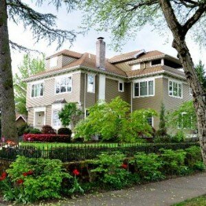
The Alameda Ridge runs through the Madison South, Roseway, Rose City Park, Beaumont-Wilshire, Alameda, and Sabin neighborhoods, with some of the most expensive homes like the one in the photo above located along the upper edge of the southern slope in the Rose City Park, Beaumont, and Alameda neighborhoods.
History of Alameda
On a high plateau above the city, the Alameda neighborhood sits on the 1859 land claim of William C. Bowering and his wife, Isabelle. The area became known as Gravelly Hill Road for a gravel pit at NE 33rd and Fremont. In 1909, the Alameda Land Company laid out the exclusive Alameda Park subdivision that was then added to the City of Portland. The Alameda History website is full of information about the neighborhood. The site is run by ‘old house’ researcher and Alameda neighborhood historian Doug Decker who is available to research your home, or to provide you with ideas and resources for you to do the research yourself. Doug is a contributing writer for the Alameda Newsletter and is always on the lookout for the next history story. Here’s an excerpt from the website about the Broadway streetcar:
Two generations of our neighbors grew up here in Alameda relying on the Broadway streetcar to take them where they needed to go. Ever-present, often noisy, sometimes too cold (or too hot), but always dependable, the Broadway car served Alameda loyally from 1910 to 1948. And though its been gone from our streets and our lives now for 54 years, physical clues remain when you learn how to see them, and neighbors are still pleased to recall their memories about one of Portland’s premier streetcar routes.
Origin of the Name Alameda
The name comes from the Spanish word “alamo,” meaning a poplar or cottonwood tree. “Alameda” means, precisely, a public walk or promenade lined with poplar trees, and, by extension, a street lined with trees. Like the English word for a “parkway.”
Schools in the Alameda Neighborhood
Find your school attendance area or a school site and view the boundary area using School Locator. Read how to use the interactive map by clicking on the “Information” icon (circle with an “i” in the center).
- Schools in the Neighborhood A list of public and private schools in the Alameda neighborhood.
- Public Schools in the Neighborhood Elementary: Alameda Elementary. Middle: Beaumont Middle School. High school: Grant High School.
- School Report Cards Report Cards for schools and districts in Oregon. Select “Portland SD 1J” to view individual schools within the Portland Public School District.
Alameda Home Styles
English Tudor, Queen Anne, and bungalows. Traveling north of Fremont, you will leave the symmetric grid-blocks and begin ascending in elevation, and the streets start running at angles, and some are circular. This hilly area is called the Alameda Ridge. Some of the homes on the ridge have commanding views of the West Hills, the Willamette River, and downtown.
Portland Monthly Magazine Guide to Neighborhoods
 In their April issue every year, the Portland Monthly Magazine features the past year home prices along with other information about Portland neighborhoods and suburban communities. To read the magazine’s latest stories and numbers visit the Real Estate section.
The numbers on the website and the printed magazine are divided into four sections (real estate, people, crime, and lifestyle) on each of the Portland 90 plus neighborhoods as well as about 25 suburban communities. The website offers over 50 items of information about each Portland neighborhood and suburban community.
The magazine added a feature on their website for homes sold in 2014 and it’s also available for homes sold in 2015 — an interactive map where you can click on a neighborhood and a pop-up displays five items (1-year median price change, 5-year median price change, median gross rent, walkability score and percent of newcomer) for a Portland neighborhood as well as a suburban community. Note the detailed numbers for each of the four sections for homes sold in 2015 are displayed below the map.
To visit the magazine’s website latest stories and numbers visit their Real Estate section — click on “Neighborhoods” to view the numbers for the Portland neighborhoods and click on “Suburbs” for the numbers on communities in the metro area. Note the detailed numbers for each of the four sections for homes sold in 2014 and 2015 are displayed below the map. To access the Portland neighborhoods and metro communities demographic data and home prices by year:
- 2013 Demographics and Home Prices
- 2014 Demographics and Home Prices
- 2015 Demographics and Home Prices
- 2016 Demographics and Home Prices
Alameda Demographics Below is some facts about the Alameda neighborhood gleaned from the magazine’s website. A few numbers can tell much about the character of a neighborhood.
- Average year homes built in the neighborhood: 1928
- Percent of residents below poverty level: 7.2%
- Percent of neighborhood land area that is in parks: 0%
- Percent of residents that live within half a mile of a park: 85%
- Percent of residents that commute by bike or walking: 16.8%
1Alameda Home Prices: 2007-2016
- Number of Homes Sold in Alameda—► 93 homes sold in 2016 and 0% distressed sales. 101 homes sold in 2015 and 0% distressed sales. 94 homes sold in 2014 and 1% were distressed sales. 101 homes sold in 2013 and 1% were distressed sales. 95 homes were sold in 2012 and 6% were distressed sales. 73 homes were sold in 2011 and 11% were distressed sales. In 2010 there were 53 homes sold and 9% distressed property sales.
- Median Price for Homes Sold in Alameda—► $675,000 in 2016 and the cost per square foot was $251. $685,000 in 2015 and the cost per square foot was $236. $592,000 in 2014, $530,000 in 2013, $510,000 in 2012, $490,000 in 2011, $495,000 in 2010, $488,000 in 2009, $538,000 in 2008, and $530,000 in 2007.
- 1-Year Median Sales Price Change in Alameda—► -2% sale price change in 2016. 15.7% sale price change in 2015. In 2014 the sales price change was 12%. In 2013 the change was 4%, in 2012 the change was 4%, in 2011 the change was -1%, and in 2010 the change was 1%.
- 5-Year Median Sales Price Change in Alameda—► 34% sales percent change for years 2012-2016. 39.8% sales percent change for years 2011-2015. 2010 to 2014 the sales price change was 10%. 2009 to 2013 the sales price change was -1%. 2008 to 2012 the sales price change was -5%. 2007 to 2011 the sales price change was -6%. 2006 to 2010 the sales price change was -5%.
- Portland Metro Area Median Home Price—► $347,000 in 2016, $308,000 in 2015, $285,500 in 2014, $310,600 in 2013, $235,000 in 2012, $221,000 in 2011, $239,900 in 2010, $247,000 in 2009, $278,000 in 2008, and $290,000 in 2007.
- Portland Metro Area Average Home Price—►$395,000 in 2016, $354,500 in 2015, $333,000 in 2014, $265,000 in 2013, $275,000 in 2012, $263,300 in 2011, $282,100 in 2010, $289,900 in 2009, $330,300 in 2008, and $342,000 in 2007.
Please be aware that the above figures are subject to error and are intended as guidelines only.
Find a Home in the Alameda Neighborhood i
- Homes for Sale in the Alameda Neighborhood — View on all devices except Apple® mobile devices. To view homes for sale in the Alameda neighborhood on Apple® mobile devices key in “Alameda” in the “Location” field and click on the “Search Now” icon.
- Displays Homes for Sale in the Alameda Neighborhood — View on all devices. Photos of home displayed along with detailed description of the property.
- Search for Homes — Search on all devices. Map-based on devices configured with Adobe Flash and Javascript and text-based on any device.
Homes for Sale in Alameda
2650 Ne Alameda St Portland, OR 97212

3503 Ne Morris St Portland, OR 97212

3214 Ne Fremont St Portland, OR 97212

2827 Ne 31st Ave Portland, OR 97212

3215 Ne 32nd Pl Portland, OR 97212

2403 Ne Klickitat St Portland, OR 97212

3141 Ne 30th Ave Portland, OR 97212

3284 Ne Klickitat St Portland, OR 97212

3076 Ne 31st Ave Portland, OR 97212

3144 Ne 24th Ave Portland, OR 97212

3116 Ne Siskiyou St Portland, OR 97212

2948 Ne 24th Ave Portland, OR 97212

3265 Ne Fremont St Portland, OR 97212

3127 Ne 33rd Ave Portland, OR 97212

2924 Ne Fremont St Portland, OR 97212

Parks in the Neighborhood
The neighborhood does not have a park within in borders. Here are two parks on Alameda’s borders:
- Wilshire Park is located on the neighborhood northeast border. The 14.40-acre park includes a picnic area, restroom, dog off-leash area, horseshoe pit, paths, playground, soccer field, softball field, volleyball court, and wading pool or splash pad.
- Grant Park is located on the neighborhood southeast border. The 19 plus acre park includes a baseball field, basketball court, restroom, dog off-leash area, football field, fountain, paths, picnic site, playground, soccer field, softball field, lighted tennis court, track, and wading pool or splash pad.
The Matt Dishman Community Center is located at 77 NE Knott Street (about 1.5 miles from Alameda’s East border) and includes a basketball court, fitness room, gymnasium, party room, an indoor swimming pool, and weight room. Alameda does not have any park land and open spaces according to Metro and the Portland Department of Parks and Recreation.
Walking in Alameda
- Alameda Ridge This 4.4-mile loop through Alameda includes a turnaround block at a 1927 mansion built by lumber baron Thomas Autzen. The walk’s many stairs, beautiful homes, and great views make it a fun adventure.
- Pearson Farm This short walk of just over half a mile will take you around the perimeter of the Pearson Farm, one of the earliest settlements in Alameda, dating to 1875. The starting point for this one is easy: the Pearson Pine at NE 29th and Fremont. Stand under its broad branches and be prepared for time travel back to our neighborhood’s past.
Walk Score helps you find a walkable place to live. Walk Score is a number between 0 and 100 that measures the walkability of any address. Portland is the 14th most walkable city in the U.S. with a Walk Score of 63, a Transit Score of 50 and a Bike Score of 72. There are over 3,000 restaurants and coffee shops in Portland. People in Portland can walk to an average of five restaurants and coffee shops in five minutes.
The Walk Score for the Alameda neighborhood is 60, the Transit Score is 47, and the Bike Score is 74.
Alameda
Somewhat Walkable
Walk Score®
60
out of 100

More About Alameda
Learn more about the Alameda Neighborhood by visiting Portland Maps. The site provides information about businesses, demographic data, crime stats, parks, schools, aerial photos, maps, elevation, and more for the neighborhood. All you need is a property address — use “2866 NE Alameda Street” or an address of your choice.
- Neighborhood Association Website Click here to access the Alameda neighborhood website.
- Location From downtown cross over the Willamette River on the Broadway Bridge and head north on NE Broadway. Take a left on Martin Luther King, Jr. Boulevard. Turn right on NE Fremont Street – when you pass NE 21st Avenue look right or left, and you’re in Alameda.
- Boundaries of Alameda North – NE Prescott. South – NE Knott. East – NE 33rd Avenue/NE 37th Avenue. West – NE 21st Avenue. The southwest corner of Alameda overlaps with part of the Alameda neighborhood.
- Map of Boundaries Alameda
- Topography Hilly on the Alameda Ridge. Mature trees and wooded parks.
- Sidewalks and Streets The street pattern is a pleasing combination of grid and winding streets on the Alameda Ridge. The neighborhood has sidewalks for walking.
- 2Drive Time to Downtown 12-13 minutes by car.
- Public Transportation TriMet has three bus routes in Alameda. No MAX light rail or streetcar lines in Alameda. Transit Score provides a 0-100 rating indicating how well an address is served by public transportation. Ratings range from “Rider’s Paradises” to areas with limited or no nearby public transportation.
- Commuting 7.1% of the neighborhood residents commute using public transportation, 14.1% by biking, and 2.5% walk.
- 3Census 2010 Demographics Population: 5,214 people. Area (acres): 393. Average population density: 13 persons per acre. Number of households: 2,058. Average size of household: 2.53 persons. Median household income: $94,168. Families with children: 28.4%. Home owners: 90.3%. Renters 9.7%. Diversity: 9.7% non-Caucasian. More census data for Alameda at Portland Online and City Data.
- 4Crime Stats There were 82 property crimes (assault, arson, burglary, larceny, robbery, theft from auto, vehicle theft) in 2014. There were three violent crimes (aggravated assault, homicide, robbery, rape) committed in 2014. There were 16 crimes per 1,000 residents in 2014. For the latest crime statistics and historical data for the Alameda neighborhood, visit the Portland Police Bureau website.
- 5Shopping and Services Alameda does not have any commercial establishments within its neighborhood. NE Fremont Street has lots of coffee shops and eating places but just a few between 21st and 37th, the neighborhood’s east/west boundaries. Alameda’s residents living on the south edge of the neighborhood have to walk 7-8 blocks to NE Broadway where numerous retail establishments are located.
- Eating Out Head for NE Fremont Street either in the family auto or on foot and you will discover an array of different foods. Visit Willamette Weeks’ Restaurant Guide by Neighborhood for a list of eating places in Alameda.
- Public Library The closest branch library of the Multnomah County Library system is the Albina at 3605 N.E. 15th Avenue.
- Who Lives in Alameda Well-established people who own their homes! The 2010 census revealed that 19.6% of the residents owned their home ‘free and clear.’ The median age of an Alameda resident is 41 according to Census 2010.
- Autos in the Neighborhood Subarus are common. Volvos are the luxury car of choice in Alameda. If you have a Toyota Camry, you’ll fit right in.
- 6Biking Quality is fair. Alameda has 0.7 miles of bike lanes.
Map of the Alameda Neighborhood
_______________________________________________