Guide to West Hills Neighborhoods
in Portland, Oregon
For in-depth information about the below West Hills neighborhoods, just click on the links below
Arlington Heights ♦ Forest Park ♦ Hillside (aka King’s Heights)
Southwest Hills ♦ Council Crest and Portland Heights
___________________________________________________________
 Someone once made the remark that Portland’s West Hills was Boston’s Beacon Hill without the dress code. The dress code in Portland is a bit relaxed as Gore-Tex is more common than cashmere. One similarity between Boston and the West Hills of Portland is both share narrow streets.
Perhaps you have heard the Everclear musical group’s song with the line, “I will buy you that big house, way up in the West Hills.” Everclear is from Portland, and they are referring to Portland’s West Hills where Everclear’s founder Art Alexakis lived in the late 90s.
Carl Abbott, in his book Greater Portland, talks about the development of the West Hills. Below is a quote:
“The advent of family automobiles opened the steep slopes to the west to residential development. By the 1920s the West Hills were Portland’s new elite district. For three generations the affluent highlanders of King’s Heights, Arlington Heights, Willamette Heights, Portland Heights, and Council Crest have enjoyed views of Mount Hood and ten-minute commutes to downtown offices. Separated by elevation from the lower income residents of the downtown fringe, successful businessmen, ambitious professionals, and monied families have been able to maintain social status and leafy living without needing to flee to suburbia.”
It certainly easy to understand why someone who works downtown would want to live in the West Hills. But the West Hills is also home to many of the computer chip workers located in Hillsboro as well as Nike employees who work at the corporate headquarters in Beaverton — these communities are located on the far west side of the Portland metro area. Rather than live in the suburbs close to their work, many chose the West Hills. They prefer the classic architectural style of older homes, the quality education available in the West Hills area public schools, and to be close to a vibrant downtown.
Just as you get to know your U.S. Postal Service carrier, the person has gone on to a different route. It usually one with a flat terrain. Most carriers don’t like the winding roads and if they walk their route, it up and down the hills so it makes for a sturdy soul. This is all due to the seniority system and bidding on routes. So as soon as they get some seniority, off they go to the flat lands.
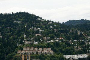
West Hills Location From downtown look West and you’ll see the West Hills. The hills extend along a ridge that covers both the northwest and southwest (south and north of Burnside Street). A simple definition is that area to the immediate west of downtown where many of the homes offer a view such as the one in the photo above. The following are West Hills neighborhoods: Arlington Heights, Council Crest, Hillside, Forest Heights, Forest Park, Northwest Heights, and Portland Heights.
West Hills Neighborhoods of Winding Roads, Hills, and Classic Homes
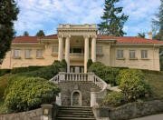 The West Hills are littered with historic homes and even a couple of castles. Common styles found in the hills include English Cottage, Foursquare, Colonial, Tudor, and Arts & Crafts. Most West Hills homes were built in the early part of the 20th Century. Many homeowners in the hills have built additions and/or updated their West Hills home so what started as a home with a definite style in its original state, is today a home lacking any architectural style.
When “pier” construction (concrete piers with steel and/or wooden beams) began in the late 1950s, builders began to construct homes on steeper lots. Today, contemporary homes are being built on narrow and steep lots. These modern homes are multi-level structures with lots of glass. Many homes in the West Hills are without a lawn – just lots of scrubs, flowering plants, and roses.
The downside of living in the West Hills is driving the up and down winding roads. The West Hills is not a grid layout. Few streets run in one direction. Another thing about West Hills living; you may experience a short power outage or two during the winter, usually during a wind or ice storm. A fallen tree or a large branch is usually the culprit.
West Hill Slides
During the winters of 1996-97, when the Portland area received record rainfall, the West Hills had over 350 slides (the entire metro area had 630 plus slides). The majority of the slides caused minor damages but a few wiped out homes and a some caused structural problems to homes. Many people were shocked to learn that their standard insurance policy didn’t cover slides.
Because of the ’96 slides, the City of Portland requires geotechnical engineers in slide hazard zones to drill soil samples, evaluate the firmness of underlying soils and measure depths to bedrock. The city requires geotechnical reviews at new building sites or for major remodeling projects, existing homes and buildings do not get the same scrutiny.
As a result of the renewed study, what became better known is that most of the homes in the West Hills are built on glacial loess –windblown glacial particles. The windblown silt ranges from a few feet deep in some places to 100 feet in others over basalt. Although most have survived just fine through decades of Oregon rainstorms, there can still be problems. Portland State University Bill Burns states that “The particles are not as packed together as they could be, which makes them more moisture sensitive. Combine that with the steep slopes and the risk for landslides goes way up.”
Determine a Property’s Exposure to Slides and Earthquakes As part of its mission to assess geological hazards and natural resources to protect the life, safety and welfare of Oregonians, the Oregon Department of Geology & Mineral Industries, in partnership with the United States Geological Survey, has acquired 441.5 square miles of digital Light Detection and Ranging (LIDAR) data for portions of the Portland metro area and the Columbia River. Other government authorities, such as the City of Oregon City, also have acquired and provided LIDAR data.
How to Use LIDAR to Access Slide and Earth Quake Information for Properties in the Portland Metro Area
Here is the link to LIDAR: http://www.oregongeology.org/sub/lidardataviewer/. You can access the interactive maps in one of three ways:
- Click on a landmark
- Type a street address or intersection within the mapped area
- View the entire metro area map
You can zoom directly to your address, if it is in the mapped area. The Help text is very useful to fully understand how the LIDAR system works and it explains many of the terms.
To read more about landslides and what homeowners can do about them, visit Earthquakes and Landslides.
Why People Live in the West Hills
West Hills doctors, lawyers, VPs, managers, and small business owners have one of the shortest commutes in the USA; just minutes to their downtown office. Evenings, they can attend a performance downtown and be sound asleep in the West Hills home minutes after the outing. While they sleep, their contemporaries are still driving the freeway heading to their home in the suburbs.
Portland Monthly Magazine Neighborhood Guide
 In their April issue every year, the Portland Monthly Magazine features the past year home prices along with other information about Portland neighborhoods and suburban communities.
The numbers on the website as well as the printed magazine are divided into four sections (real estate, people, crime, and lifestyle) on each of the Portland 90 plus neighborhoods as well as about 25 suburban communities. The website offers over 50 items of information about each Portland neighborhood and suburban community. There is more data online than in the printed magazine.
The magazine added a feature on their website for homes sold in 2014 and it’s also available for homes sold in 2015 — an interactive map where you can click on a neighborhood and a pop-up displays five items (1-year median price change, 5-year median price change, median gross rent, walkability score and percent of newcomer) for a Portland neighborhood as well as a suburban community.
To visit the magazine’s website latest stories and numbers visit their Real Estate section — click on “Neighborhoods” to view the numbers for the Portland neighborhoods and click on “Suburbs” for the numbers on communities in the metro area. Note the detailed numbers for each of the four sections for homes sold in 2014 and 2015 are displayed below the map. To access the Portland neighborhoods and metro communities demographic data and home prices by year:
- 2013 Demographics and Home Prices
- 2014 Demographics and Home Prices
- 2015 Demographics and Home Prices
Walking in the West Hills
 Walk Score ranks 2,508 neighborhoods in the largest 40 U.S. cities to help you find a walkable place to live. The top 7 neighborhoods in Portland are Walkers’ Paradises. 45% of Portland residents have a Walk Score of 70 or above. 83% have a Walk Score of at least 50—and 17% live in Car-Dependent neighborhoods. We have created a Walk Score for each of the neighborhood profiles below. Please note that we use an address in the center of each neighborhood to determine the Walk Score. Scores will vary in a neighborhood depending upon the address.
- Portland Heights to Zoo Walking Tour This 5.6-mile walk combines stunning views of downtown and the Cascades, 19th century homes, wooded paths and a ride on Portland’s only subway. Stop for a snack at Strohecker’s Grocery on your way to an afternoon visiting the Oregon Zoo. Click here to download the guide.
- Portland Hill Walks is no ordinary guidebook. No restaurant ratings, no rehashed explanations of how the city got its name. Instead, in twenty meandering, view-studded strolls from forested canyons to cityscape peaks, this lively travelogue answers questions you may never have thought to ask. It’s available from Timber Press here in Portland. Here is a review from The Oregonian: “Pick up a copy of Portland Hill Hikes, lace up some hiking shoes and leave the gas guzzler in the garage. Takes explorers into 20 city neighborhoods and includes lots of city history, while pointing out fun ways to get to know your backyard.”
- Southwest Trails Group The SW Trails Group is a committee of Southwest Neighborhoods Inc that uses volunteer efforts to make trail improvements, lead walks, work with Safe Routes to School, plan and advocate for pedestrian and bicycle safety and other improvements in SW Portland Their walks are the second Saturday of each month, meet at 9 a.m. sharp under the Hillsdale Oak, behind the Dance Studio at SW Sunset Blvd and SW Capitol Highway near the concrete bleachers of the Wilson football field.
Search for Homes in Portland’s West Hills
![]() To search for homes in Portland’s West Hills, go to SpatialMatch®, a real-time interactive geo-spatial search platform that delivers a totally new way to search for real estate online. Every aspect of the search process is conducted on the map, creating a fluid and entertaining user experience.You can specify the criteria and obtain all the current listings that match in the West Hills of Portland as well as a specific neighborhood.
To search for homes in Portland’s West Hills, go to SpatialMatch®, a real-time interactive geo-spatial search platform that delivers a totally new way to search for real estate online. Every aspect of the search process is conducted on the map, creating a fluid and entertaining user experience.You can specify the criteria and obtain all the current listings that match in the West Hills of Portland as well as a specific neighborhood.
Complete Information About West Hills Neighborhoods
Arlington Heights and Southwest Hills are located in the Southwest quadrant and Forest Park and Hillside are in the Northwest quadrant. For more information on all of the 17 Southwest neighborhoods visit the Southwest Neighborhoods website.
Below are four West Hills neighborhoods.We have created separate web pages for each to give you details about each of them.
- Arlington Heights
- Forest Park
- Hillside (aka King’s Heights)
- Southwest Hills (Council Crest and Portland Heights)