| Subscribe to the Moving to Portland Newsletter |
35°F
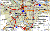
Guide to the City of West Linn |
 West Linn is home to just over 25,000 residents and it's seen as a quiet bedroom community ideal for raising a family. The 7.5 square mile area has a good mix of older homes and established neighborhoods along the Willamette River to the soaring views of the area's luxury hilltop homes.
The town is known for a low crime rate and high median household incomes. A list of the top 100 small U.S. cities to live in, compiled by CNN Money Magazine, ranked West Linn at No. 64. It ranked the highest of the two Oregon cities listed − the other was Lake Oswego, at No.79. A study conducted by the consumer advocacy Web site Nerdwallet in 2013 found what many in West Linn already know: The city is one of the best in Oregon for raising a young family. West Linn ranked seventh on Nerdwallet's top 10 list, just ahead of Sherwood, Oregon (10th). Neighboring Lake Oswego did not make the list. The study was based on three components: quality of public schools, affordability and economic growth. West Linn ranked particularly high in median household income ($92,342) and education quality (a 9 out of 10 rating from the nonprofit GreatSchools). West Linn's GreatSchools ranking tied with Sublimity and Enterprise for tops on Nerdwallet's list. And when it came to household income, West Linn's $92,342 was the highest by a long shot. Sherwood was the next highest, at $79,209.
City of Hills, Trees and Rivers
With Portland eight miles to the north, many who live here make their living outside the city limits. Called the City of Hills, Trees and Rivers, among West Linn's special assets are its dedicated parks (17 of them) and open spaces, where residents and visitors can stroll among Douglas firs and take in panoramic views of the Willamette and Tualatin rivers, with Mt. Hood, Mt. Adams, Mt. St. Helens and the Cascade range as a backdrop.
The one thing that West Linn is lacking is an established older downtown commercial area so West Linners shop in malls and stores along the major roads.
West Linn History
 The area was first settled in the early 1840s when Robert Moore purchased 1,000 acres of land from the "Wallamut" Indians. He built his cabin high on a slope overlooking the Willamette Falls and set about building a town, calling it Robin's Nest.
By 1846, Moore had built four flour and lumber mills, along with dwelling for his mill workers. He also operated a ferry to Oregon City. Moore became the first postmaster in 1850 and purchased an Oregon City newspaper, "the Spectator," in 1852. By then, his Linn City enterprises included a gristmill, sawmill, warehouse, wharves and a breakwater to create a basin for boats to tie up in for loading and unloading cargo. But when he died in 1857, Moore had still not seen his dream of a completed town realized.
Not long after Moore's death, a devastating fire destroyed the sawmill, gristmill, wharves and even a steamer ship docked there. Local businessmen began to rebuild, only to see their hard work washed away in the terrible floods that would come later that same year. Linn City was gone. But in 1868, the Willamette Transportation Locks Co. began operating--providing passage to shipping over the Willamette Falls. The locks have remained in continuous operation to this day.
Willamette Locks
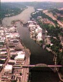 In the 1860s, Willamette Falls was a lovely sight for those who lived and worked on the Willamette River's shores. The falls -- between Oregon City and what's now known as West Linn -- cascade 40 feet over a horseshoe-shaped basalt ridge. But for river men, the falls were anything but pretty. They were dangerous and a nuisance, interrupting river traffic attempting to travel to or from Portland. That all changed in 1873, when Willamette Falls Locks opened at the edge of what's now the Bolton neighborhood of West Linn, allowing boats and their cargo to safely go around the falls.
The 130-year-old locks are a lasting link to West Linn's past. The locks continue to operate, allowing river traffic to pass -- though these days the locks' four chambers are operated by hydraulics and not by hand (as they were until the 1940s). Operators of government vessels, passenger boats, freight and towboats, log rafts, pleasure craft and jet skis may use the locks for free, both north and south of the falls. The locks are on the National Register of Historic Places.
Even aircraft have passed through the locks. The enormous Spruce Goose, built by Howard Hughes and flown just once, was transported by barge through Willamette Falls Locks in 1993, on its way to its home at the Evergreen Aviation Museum in McMinnville.
Home and Neighborhoods
Can't decide between a historic neighborhood or an area of new homes? Then West Linn may be the place for you because many of the neighborhoods offer a blend of both. Historic homes are mainly found close to the river. Simple midcentury homes dominate the area. Many West Linn homes built along the river in the 1800s are beyond rejuvenating so people buy the home for the lot, remove the old home, and build a new one. Right next to an historic home − perhaps built by a river captain or timber baron. This is especially true if your historic home is in the Bolton or Robinwood neighborhood along the river. This area has all the physical characteristics that many people desire (meandering streets, mature trees, river views, etc.).
The Willamette neighborhood, the largest of West Linn's 11 neighborhoods with close to 6,000 residents offers 12 city blocks of historic residential and commercial properties, many from the 1885 - 1915 period. An additional 28 homes elsewhere in the City are designated as historic landmark structures.
Newer homes are concentrated in the hills. The top of "the hill" − the part of town that overlooks Interstate 205, which bisects West Linn − nearly defines "bedroom community." There are pockets of retail, but there are also neighborhoods without any retail space. Houses in areas such as Parker Crest and Rosemont Summit dwarf most of the other homes in town. These hill homes have all the amenities desired such as formal dining rooms, entertainment centers, 3-car garages, and large kitchens. Plus many have views.
Along Willamette Falls Drive, off Interstate 205 across from the hill and along the Tualatin River, the neighborhood of Willamette has a downtown atmosphere, with strips of small businesses. Some of the homes here are the oldest in town.
Driving from the valley to the top of the hill is like going through different universes. In the valley, most of the residential areas have older homes built in a simple ranch style. There are older homes on the hill, but most are newer homes dwarfing those in the valley or Willamette.
Portland Monthly Magazine Neighborhood Guide
 The Portland Monthly magazine features neighborhoods in their April issue every year. It has a ton of information about Portland neighborhoods as well as suburban communities.
To help those in the housing market, the magazine combines all the data from about 120 neighborhoods and communities in the Portland metro area. Include in the document are housing prices, school ratings, demographics, crime statistics, parks, commuting information, and services. Click here to view the report
Online Maps of the City
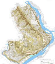 For some of the best maps (aerial, parks, contour, parade route, creeks, etc.) of the area, visit the City GIS Web site. The maps are offered by the Geographic Information System (GIS) at the City of West Linn under the Engineering Division of the City of West Linn's Public Works Department.
West Linn Walking Tour
West Linn's Willamette Historic District began as a company town established in 1893 by Willamette Falls Electric. In 1913, a typhoid epidemic led Willamette to annex to West Linn to obtain a better water source. The walk takes you through Willamette's historic streets, with a stop at Willamette Park, located at the confluence of the Tualatin and Willamette Rivers. Here you can picnic along the river while watching herons and sandpipers eat their lunch. Click here to download the guide.
Web Sites
- City of West Linn
- Clackamas County Elections Division
- CNN Money In 2005, CNN named West Linn one of the 100 Best Places to Live - West Linn was ranked 44th.
- West Linn Tidings A weekly newspaper.
- West Linn Neighborhood Associations
- West Linn Parks and Recreation
- City of West Linn 2000 Census Demographic Report Profile of General Demographics Characteristics..
More About West Linn
- Location South and a bit east of downtown. A distance of 15-18 miles depending upon the driving route.
- Origin of Name Robert Moore, the founder of the area renamed his tiny town Linn City in honor of his friend, well-known free- state advocate Dr. Lewis F. Linn, a U.S. Senator from Missouri and sponsor of the Donation Land Claim Bill.
- Neighborhood Associations The City has 11 neighborhood associations.
- Topography Gently rolling hills in the newer developments which are above the river. Flat along the river (older part of town). The older areas have mature trees in yards and parks.
- Public Transportation West Linn has two bus route. View a map and schedule for buses.
- 1Drive Time to Downtown About a 30-minute drive to downtown Portland once you get on I-205 to Highway 224 to Highway 99.
- 2Census 2010 Demographics Population: 25,109. Area size: 7.39 square miles. Number of households 10,035. Median household income of $84,290 (metro area median household was $49,260). Diversity: 9.3% non-Caucasian. Median value of owner-occupied housing units: $416,900. Percent of residents over 25 years of age holding a bachelor's degree or higher: 54.3%. See City Data for more information about West Linn. The 2010 census Profile of General Demographics Characteristics: City of West Linn 2010 US Census Demographics.
- Crime Stats In 2011 there were 9 violent crimes and total crimes per 1,000 residents was 11. Violent crimes are defined as murder, rape, robbery, and aggravated assault. Crimes per 1,000 are based on reported incidents of violent crime, as well as burglary, larceny, and motor vehicle theft. The latest crime stats are available at the West Linn Police Department.
- Sex Offenders Click here for the State of Oregon Sex Offender Inquiry System. After agreeing to the "Conditions of Use Statement" you will be redirected to a "Enter Search Criteria" page. Insert a zip code in the "Zip" field and click on the "Query" button.
- 3Shopping and Services Number of supermarkets: 4. Number of health cubs: 5. Number of public libraries: 1. This is the land of malls: big ones and little ones.
- Renters vs. Home Owners Owner occupied: 78.6%. Renter occupied: 21.4%. Median value of owner-occupied housing units was $416,900 according to Census 2010.
- Parks The City of West Linn has 548 acres of parks and open spaces. They have about 20 different parks. These growing community is continuously building and planning new parks. As a demonstration of West Linn's commitment to parks, they have been named as a Tree City for 11 years.
- Who Lives in West Linn Families drawn to the school system as well as people whose families have always lived in the area. The median age is 42 and with almost 7,000 kids attending school, the community has a strong interest in the quality of their schools. This is not a walkable city as the average Walk Score is 45.
- They Probably Drive Hill homes will have at least one SUV along with a foreign made sedan in the garage or driveway. Pickups are rare and you'll see a few vans.
- Biking West Linn has eight miles of bike lanes.
- Schools West Linn and Wilsonville School District Each community has a high school as well as at least one middle school. Both have numerous elementary schools.
- 4School Report Card Grades Elementary schools: O/S. Middle schools: O/S. High school: O/S. Click here for report card details.
5West Linn Home Prices
- Number of Homes Sold in West Linn—► 506 homes were sold in 2012 and 23% were distressed sales. There were 371 homes that sold in 2011 and 11% were distressed sales. In 2010 there were 337 homes sold and 23% were distressed properties sales.
- Median Price for Homes Sold in West Linn—► $349,998 in 2012, $320,000 in 2011, $350,000 in 2010, $370,000 in 2009, $410,000 in 2008, and $444,900 in 2007.
- 1-Year Median Sales Price Change in West Linn—► In 2012 the sales price change was 8%, in 2011 the sales price change was -13%, and in 2010 the change was -2%.
- 5-Year Median Sales Price Change in West Linn—► 2008 to 2012 the sales price change was -18%. 2007 to 2011 the sales price change was -28%. 2006 to 1010 the change was -12%.
- Portland Metro Area Median Home Price—► $235,000 in 2012, $221,000 in 2011, $239,900 in 2010, $247,000 in 2009, $278,000 in 2008, and $290,000 in 2007.
- Portland Metro Area Average Home Price—► $275,000 in 2012, $263,300 in 2011, $282,100 in 2010, $289,900 in 2009, $330,300 in 2008, and $342,000 in 2007.
Search for Homes in West Linn
![]() To search for homes in West Linn, go to SpatialMatch®, a real-time interactive geo-spatial search platform that delivers a totally new way to search for real estate online. Every aspect of the search process is conducted on the map, creating a fluid and entertaining user experience. You can specify the criteria and obtain all the current listings that match for West Linn. If you save your search criteria, you will be given the option to have new listings that match your criteria automatically e-mailed to you.
To search for homes in West Linn, go to SpatialMatch®, a real-time interactive geo-spatial search platform that delivers a totally new way to search for real estate online. Every aspect of the search process is conducted on the map, creating a fluid and entertaining user experience. You can specify the criteria and obtain all the current listings that match for West Linn. If you save your search criteria, you will be given the option to have new listings that match your criteria automatically e-mailed to you.
Below you can see SpatialMatch's map displaying homes currently for sale in West Linn (Zip code 97068):
- Click here to view a video tutorial about the SpatialMatch® Search system.
- To determine a property exposure to landslides and earth quakes, insert the address of the property into the LIDAR system.
- Your feedback about the SpatialMatch® system is welcome by emailing This email address is being protected from spambots. You need JavaScript enabled to view it. .
_________________________________________________________
1Drive Time to Downtown Estimated commuting time obtained from Yahoo Maps and Google Maps. Drive time was calculated from a central intersection in each neighborhood to Pioneer Courthouse Square during the morning peak commute time.
2Demographics Data Numbers were obtained from Census 2010 and www.portlandmaps.com.
3Shopping and Services Numbers were determined from local directory listings and county/municipal library systems.
4School Report Card Grades "O" = Outstanding; "S" = Satisfactory; "I" = In Need of Improvement.
5Real Estate Values Data on real estate values provided by RMLStm. Distressed properties refer to the percentage of total homes sold that were short sales and bank-owned properties.