Portland’s Geography
The Lay of The Land
Portland is located at the northern end of the Willamette Valley, a rich and diverse agricultural region. The long growing season and mild temperatures of the Willamette Valley are favorable for a diversity of agricultural products. Due to the high ground water level, irrigation is widely used to raise cannery crops, berries, grass seed, and pastures. Portland (city center) is situated at 20 feet above sea level, near the confluence of the Columbia and Willamette rivers.
Portland lies midway between the lower Coast Range to the west and the high Cascades Range to the east, each about 30 miles distant.
The skyline is dominated by two Cascades Range volcanoes, Mount St. Helens (8,300 feet high) about 40 miles northeast of Portland, and Mt. Hood (11,238 feet) about 40 miles to the east. Mount Jefferson defines the southeast edge. With some stretching here and tucking there, these landmarks coincide well with the edges of the CMSA (Consolidated Metropolitan Statistical Area). We can think of it as the areas that can now be reached in one and a half to two hours in a vehicle – roughly a seventy-five-mile radius around the original city.
City Layout: Five Quadrants
 For a city that’s split by a river, Portland is surprisingly easy to navigate by car, bicycle, or foot. The exception is traversing the West Hills as many of the streets curve and wind. The city is laid out in quadrants−north and south are divided by Burnside Street: east and west, by the Willamette River, which features a network of ten breathtaking bridges. The official quadrants of Portland are: North, Northwest, Northeast, Southwest, and Southeast. All addresses within the city are denoted as belonging to one of these specific quadrants with the prefixes: N, NW, NE, SW or SE. Downtown Portland is located in the SW quadrant. You can get a good picture by downloading a number of maps from the Travel Portland website.
To add some confusion to the system there are some addresses that may have you driving around in circles before you located them. Though officially located in SW Portland, the RiverPlace, John’s Landing and South Waterfront neighborhoods lie in a so-called (but unofficial) “sixth quadrant” south of downtown, where addresses rise higher from west to east toward the river. This “sixth quadrant” is roughly bounded by Naito Parkway and Barbur Boulevard to the west, Montgomery Street to the north and Nevada Street to the south. East-West addresses in this area are denoted with a leading zero. This means 0246 SW California Street is not the same as 246 SW California Street. Some computer mapping programs are unable to distinguish between the two.
It took years for the city to adopt a uniform street system. The problem stemmed from the city’s expansion in the late 19th century. Portland began in the late 1840s as a few blocks on the west side of the Willamette River. It wasn’t long before it began taking up land north and south along the river and west toward the hills. Then it jumped the river to claim East Portland, Albina and St. Johns, plus neighborhoods in between and beyond. The upshot, said the late Eugene E. Snyder in Portland Names and Neighborhoods: Their Historic Origins was that “in the newly consolidated Portland of 1891 there were twelve “A” streets, twelve “B” streets, twelve “First” streets, nine “Cedar” streets and so on.”
Finally in June of 1931, the Portland planning commission came up with a plan. The city was divided into five zones: Northwest, Southwest, North, Northeast and Southeast. East-west streets remained streets; north-south streets became avenues. There are some exceptions like Southeast Hawthorne Boulevard, Northeast Sandy Boulevard, and a few others. But for the most parts, the results followed the design.
Hills in the West and Mostly Flat in the East
Looking east from downtown Portland (20 feet above sea level) you immediately notice Mt. Hood (11,235 feet – about 40 miles from downtown), the Cascade Mountain Range, and the flat landscape of the east side across from the Willamette River.
Looking west you notice the hills and some of the houses – those not covered up by the greenery − that dominate the view. Traveling west over the ridge of hills on the west side, you dip into a flat valley. Once in the Tualatin plains, looking west, your eyes will meet a gentle rising group of hills called the Oregon Coastal Range.
The plains lay in the Hillsboro-Forest Grove-North Plains-Banks area of Washington County. The plains were once the most important agricultural district in the circle around Portland. In the 1830s Hudson Bay Company employees from Fort Vancouver sometimes drove cattle over the muddy passes of the West Hills to fatten on summer grasses of the Valley. In the 1840s American wheat farmers pushed aside the British cattle. Today, the Tualatin Plains is mostly communities and industrial areas but crops still exist in a good share of the plains.
The highest point east of the river is Mt. Tabor, an extinct volcanic cinder cone, which rises to 636 feet. Nearby Powell Butte and Rocky Butte rise to 614 feet and 612 feet, respectively. To the east lies the actively volcanic Cascade Range. On clear days Mt. Hood and Mt St. Helens dominate the horizon while Mt. Adams and Mt. Rainier can also be visible in the distance.
This Google map (terrain view) displays the West Hills and the relatively flat area of the Eastside.
Highest Point in Portland
A question often asked by visitors and newcomers to the city is “where is the highest point in Portland?”. The most common answer us Council Crest, at 1083 feet. But that turns out to be incorrect because there are several areas within the Portland city limits that are significantly higher in elevation than Council Crest.
A large portion of the length of NW Skyline Boulevard is higher than Council Crest. In fact, one section of the road just touches 1200 feet, although this point is just outside the city limits. Inside of the city of Portland boundaries, the road reaches about 1180 feet above sea level just north of the Willamette Stone Heritage Site, and then reaches about 1143 feet again further north at the Skyline Memorial Gardens. Both of these points are significantly higher than any other place in Portland by at least 60 feet, with the Willamette Stone Heritage Site location almost 100 feet above the summit of Council Crest, definitely qualifying it for the title of highest point in Portland.
City of Bridges
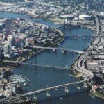 Portland is often called Bridge Town because ten bridges span the Willamette River in the metro area. The bridges of Portland are numerous and diverse. The structures, ranging in age from 30 plus years to 100 years of age, represent a variety of construction types including vertical lift spans, double-leaf Bascule drawspans, and the Fremont is the second longest tied arch span in the world. Andrew Hall’s Bridge Gallery displays all the bridges including the newest one called Tilikum Crossing.
Multnomah County maintains and operates these six Willamette River Bridges: Burnside, Broadway, Hawthorne, Morrison, Sauvie Island, and Sellwood bridges. The county also maintain 20 other smaller bridges.
The Oregon Department of Transportation maintains the Ross Island, Marquam, Fremont and St. John’s bridges. The Union Pacific Railroad maintains the Steel Bridge. The Marquam and Fremont carry traffic over interstates highways.
River traffic has priority over cars. If a lone sailboat wants one of the lift bridges raised at 3 a.m. − or in the middle of rush hour − it must be done.
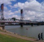 The Hawthorne bridge is the world’s oldest vertical-lift bridge and most Portlanders consider it their favorite of the ten bridges. When closed, it’s just 49 feet above the water. The Broadway Bridge, by comparison, is 85 feet above the water, the Morrison 69 feet. That means the Hawthorne rises and lowers more frequently − more than 200 times a month. The only time the bride is closed to river traffic is when we get ice or snow as just one-eighth of an inch of ice or one inch of snow adds too much weight to the span to open.
The City of Roses becomes the city of bicycles in early August each year as upwards of 12,000 people pulled on brightly colored jerseys, clamped on helmets and grabbed cameras to join in the annual Providence Bridge Pedal.
The event, extraordinary for its route over eight of Portland’s Willamette River bridges, draw Oregonians and out-of-towners of all ages. Children in bike buggies, couples on tandems and adults pedaling everything from sleek titanium racers to one-speed cruisers filled the streets and bridges from early morning until early afternoon.
Portland is Rich with Urban Rivers and Streams
Portland’s 300 miles of rivers and streams provide places to work and play. The City of Portland sits at the confluence of two of the nation’s major river systems, the Columbia and the Willamette. Native salmon, steelhead and other fish and wildlife species live within Portland’s urban boundary, and also migrate through Portland to other parts of the Willamette River Basin, Columbia River Basin, and beyond.
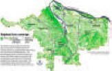
Everyone in Portland also lives in the watershed of a smaller local stream or waterway. The five watersheds with the city are Johnson Creek, Columbia Slough, Fanno Creek, Tryon Creek, and Willamette River. You can view a map of the watersheds by clicking here. Read more about the watersheds.
The Willamette River
Downtown Portland straddles the banks of the Willamette River which flows north through the city center and consequently separates the east and west neighborhoods of the city. Less than 10 miles from downtown the Willamette River flows into the Columbia River, the fourth-largest river in the United States, which divides Oregon from Washington state.
Taxpayers have spent billions of dollars cleaning the river, and today the Willamette is safe enough to kayak, wade, even full-fledged swim in. The Big Float, a public festival aimed at raising awareness at how clean the river now is, attracted 1,400 people to the water in July 2012. The next step is ensuring 365-day access, and finding a way to balance more recreational opportunities with both the needs of industry and the environmental reality that the river remains ecologically fragile. Salmon, after all, migrate along the Willamette River.
When planners and citizen activists laid out the plan for downtown 40 years ago, the Willamette River was an obstacle to be overcome. When they updated their thinking in 1988, the water had become something to be admired from a safe distance. Like the height of downtown’s two-story-high harbor wall.
Now as they craft a blueprint to carry the central city to 2035, Portland leaders hope to turn Bridgetown’s defining geographic feature into something more immediate in Oregonians’ lives: something you can literally immerse yourself in if you’re so inclined. The thinking is to allow Portlanders to interact with the river more.
Physical Features Impact Daily Living
Natural, physical features and climactic forces have considerable impact on the city, and on living in the city. Portlanders are rarely troubled by the rain, they appreciate, and delight in sunshine. Newcomers are heard to comment frequently on how green it all is. On clear days we can see Mt. Hood, Mt. St. Helens, Mt. Adams, and even Mt. Rainer.
The Landscape Architect’s Guide to Portland
The American Society of Landscape Architects debuted an online guide to Portland’s most interesting features in 2014 — from a landscape architect’s point of view. The guide is a collaboration with the local chapter and nearly a dozen Portland landscape architects who chose their favorite sights and destinations.
The guide is organized into categories, so choose the subject that interests you and find out what there is to see.
Want to show off Portland’s environment buildings? The guide sends you to the U.S. government’s lavishly updated Edith Green-Wendell Wyatt Federal Building, the Ecotrust/Jean Vollum Natural Capital Center, the Gerding Theater and the Brewery Blocks.
Got a relative who is obsessed with how people get around? Consider a transportation-related tour of Terwilliger Parkway, the Vera Katz Eastbank Esplanade, Springwater Corridor, the Portland Transit Mall and Southwest Moody Avenue.
West Hills Slides
During the winters of 1996-97, when the Portland area received record rainfall, the West Hills had over 350 slides (the entire metro area had 630 plus slides). The majority of the slides caused minor damages but a few wiped out homes and a some caused structural problems to homes. Many people were shocked to learn that their standard insurance policy didn’t cover slides.
Most slides are small and shallow, the exceptions are undated prehistoric slides under what is now the Oregon Zoo and the Washington Park Rose Garden.
Because of the ’96 slides, the City of Portland requires geotechnical engineers in slide hazard zones to drill soil samples, evaluate the firmness of underlying soils and measure depths to bedrock. The city requires geotechnical reviews at new building sites or for major remodeling projects, existing homes and buildings do not get the same scrutiny.
As a result of the renewed study, what became better known is that most of the homes in the West Hills are built on glacial loess − windblown glacial particles. The windblown silt ranges from a few feet deep in some places to 100 feet in others over basalt. Although most have survived just fine through decades of Oregon rainstorms, there can still be problems. Portland State University Bill Burns states that “The particles are not as packed together as they could be, which makes them more moisture sensitive. Combine that with the steep slopes and the risk for landslides goes way up.”
The U.S. Geological Survey in 2006 also installed monitors at Mount Calvary Cemetery in Northwest Portland to track rainfall and soil moisture, looking for a correlation between the two. That may allow them to better predict when the conditions are right for slides to occur.
Homeowners compound that risk if they let water run off their roofs or lots onto the ground around their home. The most important preventative step is to route runoff away from homes so it doesn’t infiltrate the ground and weaken the soil.
Portland State University Study
A comprehensive study by PSU geologists following the 630-some landslides that hit the region after the heavy rains of early 1996 found that “roughly 76 percent … were linked to poorly planned land-use practices on steep or unstable slopes.” They were often triggered by “uncontrolled storm-water runoff coming from roofs and streets that contributed to adjacent slope instability.” To download the study, click here.
LIDAR
State geologists are now mapping the state with LIDAR− light detection and ranging −a system that gathers high-resolution images of the surface of the earth. It employs lasers that let scientists see landslides that occurred decades, even centuries, before. State and federal scientists will combine the LIDAR maps with geologic data and records of past landslides to identify levels of hazards throughout Portland.
Trees
 Recognizing that a tree canopy can help combat climate change, and ultimately save society billions of dollars in combination with more conventional “gray” infrastructure, jurisdictions are stepping up to save existing stands and replant trees.
In the summer of 2008, Portland, known nationally for its well-treed image, launched “Grey to Green,” a five-year, $50 million, green-up-the-city initiative that includes planting 83,000 trees −50,000 of them along streets, increasing the city’s street-tree inventory by about one-fourth. A number of suburban communities are also going green, with simultaneous efforts to save trees and reduce costs. Portland has set a goal to increase its tree cover from 26 percent to 33 percent, propelled by a study it published (often cited by other jurisdictions) describing enormous public and environmental benefits from trees.
Portland has had an urban forestry department of some sort since the 1970s, before the benefits of a forested city were a common understanding. Today’s forestry department works to strike a balance between city living and maintaining a thriving forest. With 11 arborist to maintain 1.4 million trees, the department focuses on meeting goals in the Urban Forest Management Plan, such as diversifying species and planting more trees.
The forestry department is reaching out to neighborhood residents to conduct tree inventories, documenting what types of trees are where so the city can meet its species diversity goal, which helps ensure forest health. For example, to date inventories have found maples are prevalent; that means if a disease targeting maples sweeps the city, a large swath of neighborhood trees would die. Diversity helps prevent that.
Among other things, the Rose City’s street and park trees remove nearly 2 million pounds of pollutants and nearly 53 million pounds of carbon each year, according to the study, saving more than $3 million in services. Citywide, they also catch 1.3 billion gallons of storm water, according to the study, saving nearly $36 million on processing.
Urban plants and trees are thought to provide specific benefits. Kathleen Wolf, a researcher in the College of Forest Resources at the University of Washington, says studies suggest that neighborhoods with street trees have less crime, and those with plants and trees reduce stress and encourage healthy activities, like walking. Playing in a green environment, research shows, may encourage skill and cognitive development in children, as well as concentration and self-discipline.
Pavement shaded by trees can be as much as 40 degrees cooler on a hot summer day.
Since it began, Friends of Trees has planted 375,000 trees and shrubs. As part of Portland’s Gray to Green Initiative, the organization plans to dramatically increase its efforts by planting 33,000 yard trees and 50,000 street trees during the next five years.
Heritage Trees If ever there was a city of living Christmas trees, Portland is the place. Cedars, firs, pines, redwoods, spruces, all stand tall throughout the urban skyline.
Heritage Trees are trees designated by the Portland City Council as having special importance due to size, age, type or history. Portland now has close to 290 Heritage Trees that are still alive. To view a map of all the trees, click here.
- Portland’s very first Heritage Tree is an American elm at 1111 SW 10th Avenue. Its massive, leafy profile graces the front of the Portland YWCA building. It’s called the Burrell Elm because it was planted in 1872 by Martin and Rosa Burrell.
- The Douglas Fir is North America’s most plentiful softwood species, accounting for one fifth of the continent’s total softwood reserves. It is also the most common conifer in the Portland area. Macleay Park‘s 242-foot Douglas fir is probably more than 200 years old. If left uncut, Douglas firs live an average of 1,000 years.
Portland’s Urban Forest One of Top Ten in USA
Portland’s urban forest is among the top 10 in the nation, according to an American Forests report released in early 2013. American Forests’ report, funded by the U.S. Forest Service and U.S. Department of Agriculture, didn’t rank cities, but Portland was the first case study detailed in an American Forests book about successful urban forests.
The report says Portland has 23.75 park acres per 1,000 people, making more than 16 percent of the city parkland. The city has 1.4 million trees total — 1.2 million in parks and 240,000 on city streets. In its Urban Forest Management Plan, completed in 2004, the city set a goal of 33 percent of Portland’s surface area covered in urban forest; currently it’s at 30 percent, increasing 2.6 percentage points during the past nine years.
Rounding out the top-10 urban forests are New York City, with 19.51 percent coverage; Washington, D.C., with 18.99 percent; Austin, Texas, with 17.96 percent; Minneapolis with 14.58 percent; Seattle with 10.2 percent; Sacramento with 8.15 percent; Milwaukee with 9.8 percent; Denver with 6 percent; and Charlotte, N.C., with 5.5 percent.
Portland’s Tree Trimming and Cutting Rules
A new city tree code that’s been years in the making took effect on January 2, 2015. It brought new protections to trees on both public and private property, along with stricter, but easier-to-use regulations — and tough penalties for those who don’t heed them. One-third of all the trees in the city are on single-family lots, and most of those previously were unregulated.
Residents need to apply for a $25 city permit before taking down any tree on their property with a diameter of 12 inches or greater, measured 4.5 feet off the ground. They will have the right to remove up to four trees per year from their yard if the trees have a diameter of 20 inches or less — though that will require permits. Residents may be required to plant a higher number of replacement trees elsewhere, so the city doesn’t see its overall tree canopy reduced.
Permits also are required before pruning tiny branches off street trees with diameters of a quarter-inch or greater. Generally, the city will only allow full removal of street trees on the public right of way if they’re dead, dying or dangerous. Residents won’t be able to take them down just because they produce a lot of leaves, make too much shade, or obstruct views.
City of Portland Area Size
- 145.1 square miles of land and water (Seattle has 83.9 square miles of land and 53.7 miles of water).
- Land: 133.4 square miles placing it in 70th place out of 153 cities in the U.S.A.
- Water: 11.7 square miles.
City of Portland Elevations (in feet)
- Portland Airport (northeast – Columbia River): 20
- Portland Waterfront (Willamette River): 30
- Portland (City Hall): 70
- Council Crest (southwest): 1,073
- Mount Scott (southeast): 1,050
- International Rose Garden in Washington Park: 400
- Sunset Highway (Sylvan): 750
- Terwilliger (OHSU entrance): 315
- Hollywood neighborhood: 200
- Highest point in the city just off NW Skyline Drive by Skyline Memorial Gardens: 1,180
Suburban Communities Elevations (in feet)
- Beaverton: 189
- Damascus: 530
- Estacada: 1,419
- Gresham: 330
- Hillsboro: 140
- Lake Oswego (Mountain Park): 970
- Lake Oswego (State Street): 100
- Tigard: 66
- Tigard (Bull Mountain): 711
- Vancouver, Washington (Mill Plain Boulevard): 300
- Vancouver, Washington (shipyards): 30
Distances
- 173 miles south of Seattle
- 639 miles north of San Francisco
- 284 miles from the California border via I-5
- 60 minutes from Mt. Hood
- 45 minutes from the wine country of the Willamette Valley
- 40 minutes from the spectacular Columbia Gorge
- About 90 minutes from the picturesque Oregon Coast
Former Blazer
Clyde Drexler
on Portland

Quote from Clyde, undoubtedly one of the most popular Blazers, while warming up before joining a “pickup” game at the RiverPlace Athletic Club in Portland after being retired from playing and coaching.
“It’s a great place to live. We come back often, even in the winter.”
Abby Wambach
Makes Portland her Home

In late 2015 Abby Wambach retired from soccer and announced she is making Portland her home.
She scored 184 goals in international play, the most ever by any player—man or woman. She won two Olympic gold medals (2004 and 2012) and a World Cup (2015), was named FIFA’s World Player of the Year (2012), and saw the University of Florida win its first-ever national championship as a freshman (1998).
Look for a Tesla Model X on the streets of Portland and you may catch a glimpse of Abby .
Shipbuilder

Between 1940 and 1944 the Portland metropolitan population grew from 501,000 to 661,000 as Portland raced to build ships for the war.
Portland Tree Canopy
Click to enlarge
Trees of Greater Portland

Phyllis Reynolds began studying Portland’s trees in the 1980s. Phyllis is the co-author, with Elizabeth Dimon, of the guidebook Trees of Greater Portland (Timber Press, 1993), The book is crammed full of fascinating facts.
Bridge Pedal

Every August, the Portland bridge are closed to traffic so 10,000 plus bikers can enjoy the spectacular bridge views. The route includes biking over the top of the Marquam Bridge to the top of the Fremont Bridge along with 4-5 other bridges. You can choose to take the 25-mile ride or the 14-mile family ride.
Walking, Biking and Transit Maps
The City of Portland Bureau of Transportation has a many free walking, biking, and transit maps of Portland that you can order or download.
The Rose City

Most residents of Portland, if asked, would name the rose as the Portland city flower, and consider “The City of Roses” as an official city name. Many would be surprised to know that not until 2003 did the City Council adopting the City of Roses as the city’s official nickname.
Charles Paul Keyser (Portland Parks Superintendent 1917-1950) stated that Portland was christened the City of Roses by visitors to an Episcopal Church convention which was held in the city in 1888 when the Portland Rose Society was formed. In 1889 Portland’s first annual Rose Show was held and from 1904 through 1906 the Portland Rose Society sponsored a Fiesta along with its annual rose show.
City of Portland Official Flag

The four colors are blue, green, yellow and white. The blue represents the Columbia and Willamette rivers, the green signifies the forests that surround Portland, the yellow symbolizes wheat and the riches of commerce, and the white sets the colors apart.