Portland and Oregon Web Cams and Maps
 For almost all of us, Portland is a special place. It may rain a lot, but if you can put up with that, you begin to understand why people come from all over the country to live here and why most of them stay. One way of examining that phenomena is to find some of the places that say something about Portland, about its quirkiness and its charm. That’s exactly what The Oregonian did in 2009. And then they produced a series of videos to tell the city, and the rest of the world, about them. They calling the project I Love Portland. The list is long, and growing. More videos will come over time. Take a look. And e-mail your ideas for other spots around town that make Portland the city it is.
Portland Live Cams and Cameras
- TV station KGW cams Various city of Portland cams, mountains/passes, and Oregon coast cams
- Portland Airport Cams
- Pioneer Square Downtown location and referred to as “Portland Living Room.”
- Portland Metro Traffic
- OHSU Tram The tram that links the campus on the hill with the South Waterfront campus.
- River City Boat Sales A view of the docks.
- Wells Fargo Center
- Life On the Columbia River
- Salty’s Columbia River A restaurant on the river.
- Tilikum Bridge From the All Classical website — view the colorful bridge and listen to classical music streamed from the site.
- Portland A good list of cams in Portland as well as Oregon.
Pacific Northwest Cams
- Northwest Cams The Northwest U.S. has an extensive web cam network. These cameras, which are found throughout the states of Alaska, Idaho, Montana, Oregon and Washington, allow travelers to see road conditions, discover if it is snowing at their favorite ski resort, or to just sit back and take in the view from one of many very scenic web cams that are available. You can also view cams from Northern California and the California Coast.
- Hood River Cam On a windy day you can watch the kite boarders performing their stunts on the Columbia River.
- Oregon Coast Aquarium See what’s going on at the aquarium day and night.
- Tripcheck Oregon Department of Transportation cam to view road conditions within Oregon and its surrounding states.
Don Baln’s 3600 Panoramas of Oregon
Don divided the state into four regions that contains more than 450 panoramas that illustrate the state of Oregon. The four regions of Oregon follow the obvious north-south environmental divisions of the state.
- First the spectacular Oregon Coast and Coast Ranges.
- Then the long lowland of Portland and the Willamette Valley which continues through the broken country along I-5 to the California border.
- Next the Columbia River Gorge and the Oregon Cascades with beautiful waterfalls, Mount Hood, and Crater Lake National Park.
- Finally Oregon East of the Cascades, deserts and mountain ranges extending east all the way to Idaho.
If you’re not familiar with panoramas Don’s tutorial is very helpful. His work is to be admired and we thank him for his generosity in sharing it;
Oregon Ski Cams
Surveillance Cameras
Surveillance Cameras in Portland Between 11 March 2003 and 15 March 2003, Bill Brown of the New York Surveillance Camera Players was in Portland, Oregon. Brought to the “Rose City” by the independent arts group Red76, Bill began his stay by making maps of locations of surveillance cameras installed in public places. Based upon information and suggestions he received from his gracious and very generous hosts, Bill mapped out two locations: Downtown Portland and Old Town.
A Portland-area company Video Surveillance has created a Website that lets people view reported locations of ubiquitous surveillance cameras, including hundreds of the devices some estimates that are placed in downtown Portland.
CommunityCam allows the public to map and view the location of public and private cameras throughout the city. CommunityCam does not provide direct access to any video footage, and it doesn’t claim footage-seekers will be able work with private or public entities to obtain video. Nor does it guarantee that the cameras mapped at various points are actually working, are pointed in any particular direction or even are accurately reported.
Images of Ancient Volcanoes, Landslides, and River Floodplains
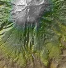
LIDAR image of Mt. Hood
Using a laser-based terrain mapping system, the Oregon Department of Geology and Mineral Industries has produced giant color images of the Portland basin, Mount Hood and the Columbia River gorge.The images, created by chief scientist Ian Madin and measuring up to 5 feet by 8 feet, were produced using a mapping program called Lidar − light detection and ranging. The program allows technicians to manipulate the image data by stripping away vegetation and buildings to show a bare earth view.
The Portland basin image shows ancient volcanoes, remnants of where the Missoula floods came through 15,000 years ago, evidence of landslides, and river floodplains that are now covered by development.
Maps
- Portlandonline.com is a rich resource of city maps (PDF format) that you can download and print. Most of them are 44″ by 34″ so it is best to zoom in on an area and then print “Current view.”
- Forest Park Forest Park is located in the West Hills of Portland and is one of the largest urban parks in the country. The Art of Geography has made a variety of maps of Forest Park.
- The Pearl District Gallery and Walking Map The Pearl Gallery map provides key information for Portland First Thursday gallery walkers. Galleries, public art, restaurants, coffeehouses, pubs & bakeries are clearly labeled on the map and in the index.
- The Portland Chocolate Map The map shows six chocolate shops within a ten block radius in Portland.
- The Portland Bakery Map This map is about baked items that focus on baked goods (breads, croissants, pies, cakes, cupcakes, cookies, etc).
- Walk and BIke Maps The City of Portland Department of Transportation has about 15 different maps of interesting sites to walk, bike, or combine the two. They also have a few neighborhood walking maps.
- Oregon Maps Oregon State Map helps in locating the prominent features of the state. Location of various cities including the capital, rivers, counties, county seats, national parks, roadways, museums, railways and golf courses are highlighted in the state map of Oregon
Weather Cams for Most States
- Weather Cams Over three million images uploaded daily along with thousands of videos created today.