Guide to the Hosford-Abernethy Neighborhood in Portland, Oregon

Hosford-Abernethy is a neighborhood in the inner Southeast section of Portland. It borders the neighborhoods of Buckman and Sunnyside on the north, Richmond on the east, Brooklyn and Creston-Kenilworth on the south, and (across the Willamette River) Downtown Portland and South Portland on the west. The neighborhood borders the Willamette River on the west, SE 29th Avenue on the east, Powell Boulevard on the south and Hawthorne Boulevard on the north. The neighborhood is a diverse combination of business, industry, and residential areas.
View a map of Hosford-Abernethy.
In the 1960s, plans were developed for a proposed Mt. Hood Freeway, which would have meant the destruction of numerous homes along Hosford-Abernethy’s southern edge closest to Powell Boulevard. This plan was shelved in 1974.
Entrance to the neighborhood from the west can be via the Hawthorne Bridge on the north boundary and the Ross Island Bridge on the south boundary. Coming into the neighborhood from the west, the first few blocks are all industrial that slowly turns into a mix of residential, including apartments, and industrial as you drive further east. Finally, at SE 13th Avenue, you’re in a residential area with detached single-family homes.
A few years ago you would have been an “urban pioneer” if you decided to buy a home in Hosford-Abernethy, but this neighborhood has changed so much (for the better) that you can still catch the trend and find an affordable home. It may require some TLC, but you will have company as many of your neighbors will be doing the same thing.
Many Small Neighborhoods Within Hosford-Abernethy
The Hosford-Abernethy neighborhood is comprised of several small neighborhoods, not receiving its official name (HAND) until the 1970s, as Portlanders began to create neighborhood associations. There is a tremendous wealth of history to the HAND neighborhood, a history that can be traced back to the area’s earliest settlements even before when it was part of the separate, incorporated city of East Portland. Hosford-Abernethy has undergone numerous changes since the mid-nineteenth century and continued its evolution to this day.
Val Ballestrem, a resident of the community and former neighborhood association board member, has written the history of the neighborhood which can be viewed online at the Hosford-Abernethy neighborhood website.
The heart of the neighborhood is located at SE 26th and SE Clinton which is two blocks south of SE Division. This is where a retail area has gradually grown so that it now contains 15 or so establishments to include restaurants, a New Seasons food market, coffee shops, a record shop, movie theater, a video store, and a gallery along with others. The businesses are spread over a 5-6 block area. All it needs is a bookstore to make it an authentic Portland neighborhood.
Another area in the neighborhood that is changing is around SE 11th Avenue and Division Street. The Ford building was purchased by Mike Tevis in 2005 and turned it into a home for artists, retail, offices, a cafe, marketing companies and other businesses. When it opened in 1914, it was a factory where Model T Fords were made. A building across the street, at 1100 S.E. Division, was formerly a Goodyear tire plant. But starting in 2012, Tevis will begin a renovation that will provide space for food cart operators and other businesses. There will be 11 or 12 spaces of about 300 to 400 square feet each and six spaces at about 1,000 square feet. The other building, at 1126 S.E. Division St., also has a history in the car industry. Currently, it houses an automotive parts wholesaler. Tevis hopes to attract light-industrial tenants such as printers to the building, which is expected to be renovated by the end of next year and will include eight spaces.
Two major public works projects are also expected to help spur growth in the area. The Portland-to-Milwaukie light-rail line that opened in September 2015 includes a MAX stop at Southeast 12th Avenue and Clinton Street, which will make the area more accessible. A streetscape project that began in early 2012 included paving, public art, new trees, crosswalks, curb extensions and other amenities.
Neighborhood Issues
One of the issues in the neighborhood is traffic. The Portland Department of Transportation awarded a grant to study traffic on Division Street, the primary route through the center of the neighborhood. The goal of the grant is to plan for a pedestrian-oriented street and encourage more local business establishments. As a result, the community has been successful in bringing in many businesses. This means that the residents can shop in the neighborhood. They want to attract community-minded business owners, and it appears to be working. The neighborhood fought a Starbucks, but the coffee house managed to open up a store on SE Division. It stayed open for a few months, and the coffee chain eventually closed the store for lack of sales.
Ladd’s Addition
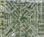
The neighborhood map reveals an uncommon street pattern just south of SE Hawthorne in an area known as Ladd’s Addition which is part of the Hosford-Abernethy neighborhood. The streets are in an orderly geometric form — a rectangle crossed by two diagonals, which divides the plat into four isosceles triangles. These are further divided into smaller triangles, quadrilaterals, parallelograms, and trapezoids. Also included were four diamond-shaped parks located on the points of a compass. It looks like a British Flag from the air layered against the grid pattern of the rest of the area. Each of these “circles” contains one of Portland’s test rose gardens, with the northern garden’s rose bushes being in a slightly different layout than the other three.
William S. Ladd platted this subdivision in 1891, and he named all but two of the streets after trees. He named one street after himself (Ladd Avenue) and another after his wife, Elliot Avenue. Two streets were later renamed because they were continuations of the grid of streets surrounding the subdivision, and some others were changed because of duplication in other parts of Portland.
The efforts to enhance the public spaces were one reason the American Planning Association honored Ladd’s Addition, declared a city historic district in 1977 and listed it on the National Register of Historic Places in 1988. Criteria for being named a great neighborhood include architectural features, accessibility, functionality and community involvement. The American Planning Association, a not-for-profit educational organization, named Ladd’s Addition one of the “Top 10 Great Neighborhoods” for 2009.
The Oregon Encyclopedia website has a history of Ladd’s Addition written by Carl Abbott, a Portland State University professor, who has written extensively on the history of Portland and the Pacific Northwest.
Origin of the Names Hosford and Abernethy
The neighborhood name came from two schools in the area: Hosford Middle School and Abernethy Elementary School. Chauncey O. Hosford was a one-time resident of Portland who owned 200 acres of land on Mt. Tabor. George Abernethy, like Hosford a Methodist missionary, was also Oregon’s first provincial governor. Neither of these men lived or owned property in the neighborhood that bears their names, but both were important in the history of Oregon and Portland.
Schools in the Hosford-Abernethy Neighborhood
Find your school attendance area or a school site and view the boundary area using School Locator. Read how to use the interactive map by clicking on the “Information” icon (circle with an “i” in the center).
- Schools in the Neighborhood A list of public and private schools in the Hosford-Abernethy neighborhood.
- Public Schools in the Neighborhood Elementary school: Abernethy. Middle school: Hosford Middle School. High school: Cleveland High School.
- School Report Cards Report Cards for schools and districts in Oregon. Select “Portland SD 1J” to view individual schools within the Portland Public School District.
Light Rail Station in the Neighborhood
The 7.3 mile Portland-Milwaukie Light Rail (Orange Line) opened for riders in September 2015. It travels past Portland State University, South Waterfront, over a new mixed-use transit bridge to OMSI and through inner Southeast on its way to Milwaukie.
The Hosford-Abernethy neighborhood has a station on the line at the intersection of SE Rhine Street and SE 17th Avenue. The station is located in the southwest corner of the neighborhood.
Read more about the Portland-Milwaukie Light Rail Line.
Home Styles
Most of the houses in Ladd’s Addition as well as the rest of the area were built between 1905 and 1920. The neighborhood architectural styles can be described as “assorted” and the quality of maintenance varies from “needs work” to pleasantly preserved. Numerous apartment buildings are located on the west side of the neighborhood. You will see Bungalows, English Cottages, and Four-squares to name a few.
In the mid-90s, eastside builder Loren Waxman built four craftsman townhomes on SE 26th and others have been built since. A small condo development was built in the early 2000s at 21st and Clinton, and more condos are starting to appear. Alternatives to detached homes mean that a new type of resident is attracted to the neighborhood.
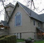
One of the more interesting buildings in the neighborhood is the Mizpah Presbyterian Church located at 2456 SE Tamarack Avenue. The building is on the National Register of Historic Places. The church is now a private residence. A photo of the building is above.
Ladd’s Addition is a National Historic District, and it was designated as one in 1988. The district boundaries: SE Division, SE Hawthorne, and SE 12th and SE 20th Streets. The district is 1,260 acres and 626 buildings. Home styles in the district include Bungalow/Craftsman along with late 19th and 20th Century Revivals.
Portland Monthly Magazine Guide to Neighborhoods
 In their April issue every year, the Portland Monthly Magazine features the past year home prices along with other information about Portland neighborhoods and suburban communities. To read the magazine’s latest stories and numbers visit the Real Estate section.
The numbers on the website and the printed magazine are divided into four sections (real estate, people, crime, and lifestyle) on each of the Portland 90 plus neighborhoods as well as about 25 suburban communities. The website offers over 50 items of information about each Portland neighborhood and suburban community.
The magazine added a feature on their website for homes sold in 2014 and it’s also available for homes sold in 2015 — an interactive map where you can click on a neighborhood and a pop-up displays five items (1-year median price change, 5-year median price change, median gross rent, walkability score and percent of newcomer) for a Portland neighborhood as well as a suburban community. Note the detailed numbers for each of the four sections for homes sold in 2015 are displayed below the map.
To visit the magazine’s website latest stories and numbers visit their Real Estate section — click on “Neighborhoods” to view the numbers for the Portland neighborhoods and click on “Suburbs” for the numbers on communities in the metro area. Note the detailed numbers for each of the four sections for homes sold in 2014 and 2015 are displayed below the map. To access the Portland neighborhoods and metro communities demographic data and home prices by year:
- 2013 Demographics and Home Prices
- 2014 Demographics and Home Prices
- 2015 Demographics and Home Prices
Hosford-Abernethy Demographics Below is some facts about the Hosford-Abernethy neighborhood gleaned from the magazine’s website. A few numbers can tell much about the character of a neighborhood.
- Average year homes built in the neighborhood: 1939
- Percent of residents below poverty level: 15%
- Percent of neighborhood land area that is in parks: 0%
- Percent of residents that live within half a mile of a park: 85%
- Percent of residents that commute by bike or walking: 24.9%
1Hosford-Abernethy Home Prices: 2007-2015
- Number of Homes Sold in Hosford-Abernethy—► 86 homes sold in 2015 and 1.2% were distressed sales. 83 homes sold in 2014 and 2% were distressed sales. 97 homes sold in 2013 and 2% were distressed sales. 81 homes sold in 2012 and 2% were distressed sales. 70 homes sold in 2011 and 19% were distressed sales. 65 homes sold in 2010 and 5% distressed sales.
- Median Price for Homes Sold in Hosford-Abernethy—► $470,000 in 2015, $480,500 in 2014, $420,400 in 2013, in$370,000 in 2012, $351,000 in 2011, $370,000 in 2010, $363,900 in 2009, $389,900 in 2008, and $346,000 in 2007.
- 1-Year Median Sales Price Change in Hosford-Abernethy—► In 2015 the change was 2.2%, in 2014 the change was 9%, the change was 14% in 2013, the change was 7% in 2012, the change was -4% in 2011, and the change was 1% in 2010.
- Average Cost per Square Foot—► $241 in 2015, $207 in 2014.
- 5-Year Median Sales Price Change in Hosford-Abernethy—► 2011 to 2015 the sales price change was 35.4%. 2010 to 2014 the sales price change was 18%. 2009 to 2013 the sales price change was 8%. 2008 to 2012 the sales price change was -5%. 2007 to 2011 the sales price change was 0%. 2006 to 2010 the sales price change was 3%.
- Portland Metro Area Median Home Price—► $308,000 in 2015, $288,500 in 2014, $310,600 in 2013, $235,000 in 2012, $221,000 in 2011, $239,900 in 2010, $247,000 in 2009, $278,000 in 2008, and $290,000 in 2007.
- Portland Metro Area Average Home Price—► $354,500 in 2015, $333,000 in 2014, $265,000 in 2013, $275,000 in 2012, $263,300 in 2011, $282,100 in 2010, $289,900 in 2009, $330,300 in 2008, and $342,000 in 2007.
Please be aware that the above figures are subject to error and are intended as guidelines only.
Find a Home in Hosford-Abernethy
- Homes for Sale in the Hosford-Abernethy Neighborhood — View on all devices except Apple® mobile devices. To view homes for sale in the Hosford-Abernethy neighborhood on Apple® mobile devices key in “Hosford-Abernethy” in the “Location” field and click on the “Search Now” icon.
- Displays Homes for Sale in the Hosford-Abernethy neighborhood — View on all devices. Photos of home displayed along with detailed description of the property.
- Search for Homes — Search on all devices. Map-based on devices configured with Adobe Flash and Javascript and text-based on any device.
Homes for Sale in Hosford-Abernethy
2585 Se 14th Ave Portland, OR 97202

2233 Se 26th Ave Portland, OR 97214

3312 Se 23rd Ave Portland, OR 97202

1815 Se 30th Ave Portland, OR 97214

1637 Se Ladd Ave Portland, OR 97214

2426 Se Market St Portland, OR 97214

2585 Se 14th Ave #a Portland, OR 97202

1720 Se Lavender St Portland, OR 97214

1711 Se Locust Ave Portland, OR 97214

2424 Se Harrison St Portland, OR 97214

2346 Se Division St Portland, OR 97202

1945 Se Harrison St Portland, OR 97214

1305 Se Clinton St Portland, OR 97202

1812 Se Woodward St Portland, OR 97202

2204 Se 26th Ave Portland, OR 97214

2116 Se Brooklyn St Portland, OR 97202

2831 Se Hawthorne Blvd Portland, OR 97214

2585 Se 14th Ave #b Portland, OR 97202

2136 Se Hawthorne Blvd #10 Portland, OR 97214

Parks and Gardens in Hosford-Abernethy

The neighborhood has one small park at SE Division and SE 27th Street called Piccolo Park which has a playground for children. Powell Park borders the neighborhood on the south side at SE 26th Avenue and Powell Boulevard. The eight-acre park includes a baseball field, basketball court, soccer field, restroom, paths, picnic site, playground, and a wading pool.
Known as the Ladd’s Circles and Squares, the circle at SE 16th Avenue and Harrison Street has a formal landscape with camellias, perennials, and a lawn area in the central circle and numerous rose varieties in the four diamonds, creating a stained glass effect. Today the gardens feature over 3,000 roses of 60 varieties that were popular in the early 20th century. The roses are cared for by Portland Parks & Recreation staff and a devoted team of volunteers, the Friends of Ladd’s Addition Gardens.
Hosford-Abernethy has two acres of parkland and open spaces according to Metro and the Portland Department of Parks and Recreation.
Walking in Hosford-Abernethy
This 2.3-mile loop travels through historical inner Southeast neighborhoods with plenty of places to eat and drink along the way. The Ladd’s Addition neighborhood has one of the most unusual street layouts in the nation: a diagonal pattern surrounding rose gardens. Getting lost on its elm-lined streets is a Portland tradition. Click here to download the guide.
Walk Score helps you find a walkable place to live. Walk Score is a number between 0 and 100 that measures the walkability of any address. Portland is the 14th most walkable city in the U.S. with a Walk Score of 63, a Transit Score of 50 and a Bike Score of 72. There are over 3,000 restaurants and coffee shops in Portland. People in Portland can walk to an average of five restaurants and coffee shops in five minutes.
The Walk Score for the Hosford-Abernethy neighborhood is 89, the Transit Score is 57, and the Bike Score is 98.
Hosford-Abernethy
Very Walkable
Walk Score®
89
out of 100
Hosford-Abernethy is the 8th most walkable neighborhood in Portland.

More About Hosford-Abernethy
Learn more about the Hosford-Abernethy by visiting Portland Maps. The site provides a list of businesses, demographic data, crime stats, parks, schools, aerial photos, maps, elevation, hazards, and more for the neighborhood. All you need is a property address – use “1637 SE Ladd Avenue”” or an address of your choice.
- Neighborhood Association Website Hosford-Abernethy. The Hosford-Abernethy neighborhood is on Facebook.
- Neighborhood News The Bee covers southeast Portland. The Southeast Examiner is a free weekly publication.
- Location From downtown cross over the Willamette River on the Hawthorne Bridge. As you drive east on SE Hawthorne Boulevard, the neighborhood will be on your right side.
- Hosford-Abernethy Boundaries North – SE Hawthorne Blvd. South – SE Powell Blvd. East – SE 29th Avenue. West – Willamette River.
- Map of Hosford-Abernethy Boundaries Hosford-Abernethy.
- Topography Flat with mature trees on properties.
- Sidewalks and Streets The street pattern is grid — the west part of the neighborhood streets are full of cars due to the many apartments. The neighborhood has sidewalks for walking.
- 2Drive Time to Downtown About 15 minutes.
- Public Transportation This neighborhood has 14 bus lines and a streetcar line that travels along the western edge of the neighborhood. The Hosford-Abernethy neighborhood has a station on the Portland-Milwaukie MAX Light Rail Orange Line at the intersection of SE Rhine Street and SE 17th Avenue — the station is located in the southwest corner of the neighborhood. See schedules and routes at the TriMet website. Transit Score provides a 0-100 rating indicating how well an address is served by public transportation. Ratings range from “Rider’s Paradises” to areas with limited or no nearby public transportation.
- Commuting 15.8% of the neighborhood residents commute using public transportation, 14.9% by biking, and 10% walk.
- 3Census 2010 Demographics Population: 7,336. Area: 824 acres. Average population density: 8 persons per acre. Number of households: 3,684. Average size of household: 2.07 persons. Median household income: $49,288. Families with children: 21.9%. Percent of home owners: 53%. Percent of renters: 47%. Diversity: 11.7% non-Caucasian. More census data about Hosford-Abernethy at Portland Online and City Data.
- 4Crime Stats There were 546 property crimes (assault, arson, burglary, larceny, robbery, theft from auto, vehicle theft) in 2014. There were 17 violent crimes (aggravated assault, homicide, robbery, rape) committed in 2014. There were 76 crimes per 1,000 residents in 2014. For the latest crime statistics and historical data for the Hosford-Abernethy neighborhood, visit the Portland Police Bureau website.
- Sex Offenders Click here for the State of Oregon Sex Offender Inquiry System. After agreeing to the “Conditions of Use Statement” you will be redirected to an “Enter Search Criteria” page. Insert a zip code in the “Zip” field and click on the “Query” button. Hosford-Abernethy code: 97202, 97214.
- 5Shopping and Services Number of supermarkets: 2. Number of health clubs: 1. Number of coffee shops: 6. New Seasons Market has a store at 1954 SE Division Street and the Peoples Coop food market is located at 3029 SE 21st Avenue. The neighborhood business community is located in a 5-6 block area of SE 26th and SE Clinton. The area has gradually grown so that it now contains 15 plus stores to include restaurants, coffee shops, a record shop, movie theater, a video store, and a gallery along with others. Drive along SE Division Street and you will notice many thriving businesses. Every community needs a hardware store, and Hosford-Abernethy has one – Hankins True Value Hardware is located at 1720 SE Hawthorne Boulevard. Click here to access a shopping guide/map of the Division Street area.
- Farmers Market People Coop at 3029 SE 21st Avenue. 2:00 pm — 7:00 pm on Wednesdays held year-round. See Peoples Coop.
- Eating Out With more than 40 restaurants—among them standouts like Pok Pok, Xico, and Ava Gene’s—lining the walkable blocks on SE Division between 20th and 50th Avenues, residents here could eat out every night for a month without repeating restaurants. The Savoy at 2500 SE Division is authentic Portland where dining room and bar features art plucked from Goodwill – the vintage furniture and other salvage items are almost as interesting as the food (American). Nuestra Cocina (means “Our Kitchen’) at 2135 SE Division is one of Portland’s hottest new restaurants serving food cooked in the central Mexico style. Located in the heart of Ladd’s Addition, on the southwest segment of the roundabout that forms the neighborhood’s center is Portland’s Palio Dessert & Espresso House where a coffee purchase comes with a side of warm banter. Visit Willamette Weeks’ Restaurant Guide by Neighborhood for a list of eating places in Hosford-Abernethy.
- Public Library The neighborhood does not have a public library but two libraries are about the same distance from the center of the neighborhood. The Belmont Library at 1038 S.E. 39th Avenue or the Woodstock Library at 6008 S.E. 49th Avenue. The Woodstock Library building was opened in 2000, and it has received numerous awards for its elegant and functional design, including a national honor from the American Institute of Architects and the American Library Association. This southeast Portland library is the home of a wealth of original artwork, including 36 stainless-steel panels on the exterior of the building etched with words depicting the history of books.
- Who Lives in Hosford-Abernethy White collar married couples in Ladd’s Addition because it takes two incomes to afford a home in that area. Many singles live in the apartments on the west side of the neighborhoods. In the rest of the neighborhood, you will find many younger married couples starting their family along with a few singles and baby boomers. The median age of a resident is 38.
- Cars in the Neighborhood Japanese cars and you’ll see a few Volvos in Ladd’s Addition. And lots of bikers − many from Hosford-Abernethy − stream into downtown via the Hawthorne Bridge in the early morning on their way to work.
- 6Biking Quality is high. There are 8.5 miles of bike lanes in the neighborhood. Bicycle Trip Planner will map a route for you and − just provide a starting point address and your destination address.
Map of the Hosford-Abernethy Neighborhood
___________________________________