Guide to the Beaumont-Wilshire Neighborhood in Portland, Oregon
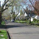
The Beaumont-Wilshire neighborhood is located in the city’s northeast section. It is bordered by the Alameda, Concordia, Cully, Rose City Park, and Grant Park neighborhoods. “Beaumont Village,” located on NE Fremont Street, from NE 33rd Avenue to NE 50th Avenue, is the main commercial district in the neighborhood, but the neighborhood also lies within walking distance of the Hollywood District, a major commercial and shopping area to the south. Urban Spoon lists 18 eating places on NE Fremont between NE 41st and NE 52nd Avenues.
Beaumont-Wilshire is an older, established neighborhood. It has a mixture of residential and commercial properties. The Beaumont-Wilshire neighborhood is actuality two separate neighborhoods separated by NE Fremont Street, with Beaumont to the south and Wilshire to the north. The two neighborhoods agreed to form the Beaumont-Wilshire Neighborhood Association to recognize their common interests, including their common commercial center of Beaumont Village.
The Beaumont-Wilshire neighborhood has a variety of home styles. South of Fremont, most of the homes were built in the early 1900s, and you will find lots of Tudors, Craftsman, and Bungalows. Once you cross Fremont heading north, you’ll find early 1900s classic styles along with a few homes that were built after 1950.
A favorite store for the neighborhood shoppers is the 5,000 square foot Beaumont Market at 4130 NE Fremont Street. In addition to the grocery items, there is an incredible amount of other stuff. Look up as it goes all the way from the floor to the ceiling, including some things hanging from the ceiling. You can always find a last minute gift item somewhere in Beaumont. They carry a good quantity of wine as well as the Harris Ranch meats and fresh produce.
History of Beaumont-Wilshire
The original Beaumont neighborhood was platted in 1910. It was an original part of the Rose City Park subdivision which was platted in 1907. The original Rose City Park subdivision was part of a 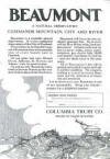
land claim of Joseph Backenstos, which was assigned to his widow by President Andrew Johnson in 1866. Early maps, around 1890, refer to this area as the Crook Tract. The south slope of Alameda Ridge, originally known as “Beaumont Hill” or “Gravel Hill,” trends northwest-southeast through the southern part of the neighborhood. The Ridge provides spectacular views of northeast Portland and the downtown skyline and boasts some of the most expensive homes in Portland. Reportedly, concrete sidewalks and curbs were poured south of NE Fremont in 1911, and the streets were paved within the following few years.
The Wilshire neighborhood was initially platted in 1921 around the area of NE 33rd and N.E. Skidmore. In 1928 the area between NE Fremont and Prescott, and from NE 42nd to 52nd was annexed into the city of Portland, and part of this annex later became the eastern part of the Wilshire neighborhood.
You will want to read the flyer above (just click on it) put out by the Columbia Trust Company in 1910 promoting Beaumont The language of the ads is very flowery as the first paragraph reads, “Beaumont is a veritable natural observatory. It is the residential observatory of the City of Portland.” The last paragraph of the ads invites you and your friends to see Beaumont in “one of our automobiles.”
Origin of the Names: Beaumont and Wilshire
Beaumont is the subdivision created in 1910. It means “beautiful mountain” in French. The neighborhood is slightly elevated, and the developers wanted to call attention to that desirable feature. The Wilshire subdivision was platted in 1921 around the area of NE 33rd and NE Skidmore.
Schools in the Beaumont-Wilshire Neighborhood
Find your school attendance area or a school site and view the boundary area using School Locator. Read how to use the interactive map by clicking on the “Information” icon (circle with an “i” in the center).
- Schools in the Neighborhood A list of public and private schools in the Beaumont-Wilshire neighborhood.
- Public Schools in the Neighborhood Elementary: Alameda K-5 and Sabin K-8. Middle: Beaumont Middle School and Sabin K-8. High school: Grant High School.
- School Report Cards Report Cards for schools and districts in Oregon. Select “Portland SD 1J” to view individual schools within the Portland Public School District.
Beaumont-Wilshire Home Styles
Bungalow, English, and Tudors south of NE Fremont. Some post-WWII (ranch style, etc.) north of Fremont.
Neighborhood Website and Blog
The Beaumont-Wilshire Neighborhood Association website is full of information and photos. It a must visit and by all means, read their newsletters and look at the annual picnic photos.
Portland Monthly Magazine Guide to Neighborhoods
 In their April issue every year, the Portland Monthly Magazine features the past year home prices along with other information about Portland neighborhoods and suburban communities. To read the magazine’s latest stories and numbers visit the Real Estate section.
The numbers on the website as well as the printed magazine are divided into four sections (real estate, people, crime, and lifestyle) on each of the Portland 90 plus neighborhoods as well as about 25 suburban communities. The website offers over 50 items of information about each Portland neighborhood and suburban community.
The magazine added a feature on their website for homes sold in 2014 and it’s also available for homes sold in 2015 — an interactive map where you can click on a neighborhood and a pop-up displays five items (1-year median price change, 5-year median price change, median gross rent, walkability score and percent of newcomer) for a Portland neighborhood as well as a suburban community. Note the detailed numbers for each of the four sections for homes sold in 2015 are displayed below the map.
To visit the magazine’s website latest stories and numbers visit their Real Estate section — click on “Neighborhoods” to view the numbers for the Portland neighborhoods and click on “Suburbs” for the numbers on communities in the metro area. Note the detailed numbers for each of the four sections for homes sold in 2014 and 2015 are displayed below the map. To access the Portland neighborhoods and metro communities demographic data and home prices by year:
- 2013 Demographics and Home Prices
- 2014 Demographics and Home Prices
- 2015 Demographics and Home Prices
Beaumont-Wilshire Demographics Below are some facts about the neighborhood gleaned from the magazine’s website. A few numbers can tell much about the character of a neighborhood.
- Average year homes built in the neighborhood: 1943
- Percent of residents below poverty level: 6.7%
- Percent of neighborhood land area that is in parks: 3%
- Percent of residents that live within a half mile of a park: 85%
- Percent of residents that commute by bike or walking: 11.4%
1Beaumont-Wilshire Home Prices: 2007-2015
- Number of Homes Sold in Beaumont-Wilshire—► 99 homes were sold in 2015 and 3% were distressed sales. 105 homes were sold in 2014 and 1% were distressed sales. 145 homes were sold in 2013 and 1% were distressed sales. 115 homes sold in 2012 and 7% were distressed sales. 93 homes were sold in 2011 and 10% were distressed sales. In 2010 there were 97 and distressed properties sales were 7%.
- Median Price for Homes Sold in Beaumont-Wilshire—► $550,000 in 2015, $512,000 in 2014, $449,000 in 2013, $387,300 in 2012, $356,556 in 2011, $365,000 in 2010, $366,000 in 2009, $405,000 in 2008, and $399,750 in 2007.
- Average Cost per Square Foot—► $244 in 2015, $211 in 2014.
- 1-Year Median Sales Price Change in Beaumont-Wilshire—► 7.4% sales price change for 2015. In 2014 the sales price changes were 14%, in 2013 the sales price changes were 16%, in 2012 the sales price was 9%, in 2011 the sales price change was -2%, and in 2010 the sales price change was -1%.
- 5-Year Median Sales Price Change in Beaumont-Wilshire—► 54.3% sales price change for years 2011-2015. 2010 to 2014 the sales price change was 30%. 2009 to 2013 the sales price change was 14%. 2008 to 2012 the sales price change was -1%. 2007-2011 the sales price change was -10%. 2006-2010 the sales price change was -4%.
- Portland Metro Area Median Home Price—► $308,000 in 2015, $285,500 in 2014, $319,600 in 2013, $235,000 in 2012, $221,000 in 2011, $239,900 in 2010, $247,000 in 2009, $278,000 in 2008, and $290,000 in 2007.
- Portland Metro Area Average Home Price—► $354,500 in 2015, $333,000 in 2014, $265,000 in 2013, 275,000 in 2012, $263,300 in 2011, $282,100 in 2010, $289,900 in 2009, $330,300 in 2008, and $342,000 in 2007.
Please be aware that the above figures are subject to error and are intended as guidelines only.
Find a Home in the Beaumont-Wilshire Neighborhood
- Homes for Sale in the Beaumont-Wilshire Neighborhood — View on all devices except Apple® mobile devices. To view homes for sale in the Beaumont-Wilshire neighborhood on Apple® mobile devices key in “Beaumont-Wilshire” in the “Location” field and click on the “Search Now” icon.
- Displays Homes for Sale in the Beaumont-Wilshire Neighborhood — View on all devices. Photos of home displayed along with detailed description of the property.
- Search for Homes — Search on all devices. Map-based on devices configured with Adobe Flash and Javascript and text-based on any device.
Homes for Sale in Beaumont-Wilshire
3422 Ne Klickitat St Portland, OR 97212

4024 Ne Alameda St Portland, OR 97212

4121 Ne Wistaria Dr Portland, OR 97212

4430 Ne 36th Ave Portland, OR 97211

4346 Ne 35th Ave Portland, OR 97211

3738 Ne Shaver St Portland, OR 97212

4594 Ne 35th Ave Portland, OR 97211

4647 Ne 40th Ave Portland, OR 97211

4538 Ne Failing St Portland, OR 97213

3411 Ne 38th Ave Portland, OR 97212

3615 Ne 45th Ave Portland, OR 97213

4406 Ne 35th Ave Portland, OR 97211

Parks in the Neighborhood
- Wilshire Park is located on the neighborhood northeast border. The 14.40 acre park includes a picnic area, restroom, dog off-leash area, horseshoe pit, paths, playground, soccer field, softball field, volleyball court, and wading pool or splash pad.
- The Matt Dishman Community Center is located at 77 NE Knott Street (about 1.5 miles from Alameda’s East border) and includes a basketball court, fitness room, gymnasium, party room, an indoor swimming pool, and weight room.
Beaumont-Wilshire has 14 acres of parkland and open spaces according to Metro and the Portland Department of Parks and Recreation.
Walking in Beaumont-Wilshire
You can walk anywhere in the neighborhood and enjoy the trees, homes, and shops along NE Fremont Street. Laura Foster’s Portland City Walks book is available from Timber Press here in Portland. The book has a 5.8-mile walk which takes you on NE Fremont Street along the Rose City Cemetery.
Walk Score helps you find a walkable place to live. Walk Score is a number between 0 and 100 that measures the walkability of any address. Portland is the 14th most walkable city in the U.S. with a Walk Score of 63, a Transit Score of 50 and a Bike Score of 72. There are over 3,000 restaurants and coffee shops in Portland. People in Portland can walk to an average of five restaurants and coffee shops in five minutes.
The Walk Score for the Beaumont-Wilshire neighborhood is 75, the Transit Score is 46, and the Bike Score is 89.
Beaumont-Wilshire
Very Walkable
Walk Score®
75
out of 100
Beaumont-Wilshire is the 28th most walkable neighborhood in Portland.

More About Beaumont-Wilshire
Learn more about the Beaumont-Wilshire neighborhood by visiting Portland Maps. The site provides information about businesses, demographic data, crime stats, parks, schools, aerial photos, maps, elevation, hazards, and more for the neighborhood. All you need is a property address – use “3626 NE 42nd Avenue” or an address of your choice.
- Neighborhood Association Website Beaumont-Wilshire.
- Location From downtown cross over the Willamette River on the Broadway Bridge and head north on NE Broadway. Take a left on Martin Luther King, Jr. Boulevard. Turn right on NE Fremont Street – when you arrive at NE 33rd Avenue look right or left, and you’re in Beaumont-Wilshire.
- Boundaries of Beaumont- Wilshire North from west to east – NE Prescott and NE Alberta Court. South from west to east – NE Morris, NE Knott, NE 43rd, NE Wistaria. East – NE 47th Avenue/NE 42nd Avenue. West – NE 33rd Avenue/NE 37th Avenue.
- Map of Beaumont-Wilshire Boundaries Beaumont-Wilshire.
- Topography Hilly on the Alameda ridge on the south edge of the neighborhood. Mature trees and wooded parks.
- Sidewalks and Streets The street pattern is a grid in the north part and some winding streets on the south edge of the neighborhood along the Alameda Ridge. The neighborhood has sidewalks for walking.
- 2Drive Time to Downtown 12-13 minutes by car.
- Public Transportation TriMet has three bus routes in Beaumont-Wilshire. The Northeast schedule and routes can be found at TriMet Website. No MAX light rail or streetcars in Beaumont-Wilshire. Transit Score provides a 0-100 rating indicating how well an address is served by public transportation. Ratings range from “Rider’s Paradises” to areas with limited or no nearby public transportation.
- Commuting 5.9% of the neighborhood residents commute using public transportation, 7.8% by biking, and 3.6% walk.
- 3Census 2010 Demographics Population: 5,346 people. Area size in acres: 470. Average population density: 11 persons per acre. Number of households: 2,319. Average size of household: 2.31 persons. Median household income: $84,807. Families with children: 25.6%. Home owners: 85%. Renters: 15%. Diversity: 11.7% non-Caucasian. More census data for Beaumont-Wilshire at Portland Online and City Data.
- 4Crime Stats There were 125 property crimes (assault, arson, burglary, larceny, robbery, theft from auto, vehicle theft) in 2014. There was one violent crime (aggravated assault, homicide, robbery, rape) committed in 2014. There were 23 crimes per 1,000 residents in 2014. For the latest crime statistics and historical data for the Beaumont-Wilshire neighborhood, visit the Portland Police Bureau website.
- 5Shopping and Services Number of food markets: 1. Number of health club: 1. Number of coffee shops: 1. The Beaumont Market on Northeast 41st Avenue and NE Fremont Street is a favorite of locals. Just a couple of blocks further east is the Beaumont “Do It Best Hardware.” Click here to access a shopping guide/map of Beaumont.
- Eating Out Numerous choices along NE Fremont which are right in the middle of the neighborhood. Walking to a dining spot is possible for many residents. Visit Willamette Weeks’ Restaurant Guide by Neighborhood for a list of eating places in Beaumont-Wilshire.
- Who Lives in Beaumont-Wilshire A cross section of people depending on which side of the “tracks” you live on. The “tracks” is NE Fremont. The median age of a resident is 41 according to Census 2010.
- Autos in the Neighborhood Autos manufactured by USA companies north of Fremont and value-packed vehicles south.
- 6Biking Quality is fair. Beaumont-Wilshire has 4.2 miles of bike lanes.
Map of the Beaumont-Wilshire Neighborhood
___________________________________