Guide to the South Portland Neighborhood in Portland
Corbett, Johns Landing, Lair Hill, South Waterfront, and Terwilliger

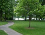
The playground at Willamette Park in the South Portland neighborhood.
South Portland is a long and narrow neighborhood just south of downtown. It’s hemmed in between the Willamette River and the West Hills. It stretches from I-405 and the Marquam Bridge on the north to SW Canby Street and the Sellwood Bridge in the south. The Willamette forms the eastern boundary, and SW Barbur Blvd. most of the western boundary. In addition to Downtown to the north, other bordering neighborhoods are Southwest Hills, Homestead, Hillsdale, and South Burlingame to the west, and Hosford-Abernethy, Brooklyn, and Sellwood-Moreland across the river on the east.
Running down the north-south length of the neighborhood along the east side is Highway 43 (also called SW Macadam Avenue). About three miles of the four miles road through the neighborhood contains commercial properties — this includes retail, restaurants, shops, and an upscale food market.
The Macadam Avenue is a busy street, especially in the morning and late afternoon as commuters crowd the road. Traffic backs up for blocks trying to cross the Sellwood bridge. The saving grace is that the road does have a median strip that makes driving tolerable. You can view a list of the business by visiting the South Portland Business Association website. The neighborhood is found east of I-5 between the Terwilliger Curves and Willamette River. From downtown Portland, this neighborhood can be reached by traveling along Naito Parkway towards the Ross Island Bridge and taking the Macadam Avenue turn off immediately before continuing across the Ross Island bridge. The neighborhood along the river is referred to as Johns Landing.
South Portland is a collection of a number of different neighborhoods. Most are historic that have existed for years but one, South Waterfront, has only been around since the beginning of the 2000s. Below you will find a short history of each.
- South Waterfront The northeastern part of the neighborhood called South Waterfront (SoWa) is the site of a large-scale, high-density district currently under construction. Oregon Health & Science University (OHSU) ran out of room on its upper campus and they are expanding along the river.
- Lair Hill This area is in the northwestern part of the neighborhood, bordered by I-405 on the north, SW Barbur Boulevard on the south and west, and SW Naito Parkway on the east. This area was part of historical South Portland, a district of Italian, Irish, and Jewish immigrants much of which was demolished by an “urban renewal” project in 1958. Vestiges remain in the form of synagogues and ethnic shops.
- Corbett The Corbett area (and SW Corbett St. running north-south through the entire neighborhood) lies east of Lair Hill, bounded by I-405 on the north, SW Naito Parkway on the west, SW Macadam Avenue on the east. Its southern boundary is marked by the SW Corbett St. bridge over I-5. This area of Portland should not be confused with the unincorporated community of Corbett, Oregon in eastern Multnomah County.
- Terwilliger This area lies south of Corbett, between SW Barbur Boulevard and SW Macadam Avenue.
- Johns Landing The area used to be known as Fulton. It’s found East of I-5 between the Terwilliger Curves and Willamette River. This section is along the river and there are numerous condos, many with river views.
For the last few years, the area’s riverfront has been converting from heavy industry to residential development at a density that is expected to double the neighborhood’s population. Offices and health care facilities employing several thousand have located along the river.
Who says you can’t combine learning and a night out? At Jolly at Johns Landing in Southwest Portland, you can do both, an especially welcome tonic on a rainy evening when bar-hopping isn’t quite an option. We’re talking about trivia nights. Every Thursday at 7:30 p.m., anyone can stop by this neighborhood sports bar at 5627 S.W. Kelly Avenue and join six rounds of trivia. Bring a friend, a group of friends, some co-workers, a special someone, your parents, your grandparents. You don’t have to be an expert on anything to participate.
Each round consists of five to 10 questions, ranging from general knowledge to funny quotes by famous people, to films, to politicians, to album covers. In one round, Pospisil will show pictures and participants must identify who’s in them. The rules are simple: You play in teams of up to seven people. The quizmaster calls out a question, and players write down the answers. The winning team gets $5 for each player.
Neighborhood Icons: OHSU Tram and Gibbs Street Pedestrian Bridge
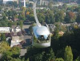
Opened in late 2006, the tram links OHSU’s Marquam Hill Campus to its first building in the river blocks. The Portland’s Aerial Tram transports researchers, students, medical professionals, patients and visitors between Portland’s foremost medical institution and its newest development. The 3,300-foot tram extends from the main Marquam Hill campus to a terminus at Southwest Gibbs Street and Moody Avenue near the Willamette River.
The Tram cabins travel 3,300 linear feet between the South Waterfront terminal adjacent to the OHSU Center for Health & Healing, and the upper terminal at the Kohler Pavilion on OHSU’s main campus. Traveling at 22 miles per hour, the Tram cabins rise 500 feet for the three-minute trip over I-5, the Lair Hill neighborhood, and the Southwest Terwilliger Parkway. More about the tram at this link.
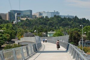
Looking west on the Gibbs Street Pedestrian Bridge, in Portland, Oregon, towards Marquam Hill and OHSU. Photo by Steve Morgan.
The City of Portland built a new bike and pedestrian bridge over I-5 that opened in July 2012 to connect the historic Lair Hill neighborhood with the South Waterfront District. The Gibbs Street Pedestrian Bridge means that residents of Portland’s Corbett and Lair Hill district are now reconnected to the city’s waterfront.
The building of Interstate-5 in the early 1960s cut off parts of what is now called the South Portland neighborhood from the Willamette River. It’s only a short distance from Lair Hill to South Waterfront, but pedestrians and cyclists trying to get between the two must negotiate the freeway and other hard-to-cross, high-traffic areas such as Macadam Boulevard, Naito Parkway and the ramps for the Ross Island Bridge. But now, instead of making a circuitous, unpleasant one-mile-plus trip, pedestrians and cyclists can walk or ride over the freeway on the span of the new bridge, the official name of which is the U.S. Congresswoman Darlene Hooley Pedestrian Bridge at Gibbs Street. The bridge is being named for the retired U.S. representative who was instrumental in securing funding for the bridge and pushing the project through.
History
The South Portland Historic District was built between the 1870s and the 1920s and it was the home to Italian and Jewish immigrants. The area thrived in the early years since the population of Portland, all on the west side (East Portland was a separate city), was increasing rapidly and the area was a relatively easy place to develop, being a broad bench between the river and the West Hills. The first streetcars in the mid-1870s helped spur growth.
The decline started in the 30s when immigrants moved on to newer, most upscale neighborhoods in Portland. In the 50s, homeowners left for the suburbs and outlying neighborhoods. In the 70s, Corbett and Lair Hill was the area to get your hash pipe and other countercultural sundries. The construction of I-5 in the 60s devoured more of the streets and long-time neighbors were now cut off. Attracted by the cheap rents, students from Portland State University, Lewis and Clark College, and Oregon Health and Science University moved in. The area was dying, full of renters, and the prospects for the neighborhood looked dim. By the 70s, the neighborhood was discovered or perhaps rediscovered. Maybe by the educated people who were its renters. Activists realized its potential – live close to downtown in a historic home and buy it for the right price. Now that bungalow, purchased in the 70s – 80s for a song and renovated, is worth 4-5 times as much.
The Portland “neighborhood revolution” started in the South Portland community. The community organized in 1969 to fight the South Auditorium urban renewal project. The city wanted to clear parts of the Lair Hill neighborhood, located just south of the downtown urban renewal zone. Three other neighborhoods joined to develop their own district plan to preserve fragments of old South Portland and Fulton. This backlash resulted in the establishment of the Lair Hill Historic Conservation District, the first protected historic district in Portland. This was followed by other Portland neighborhoods protesting other urban renewal projects.

Poina Olsen describes South Portland’s population in her book entitled Stories from Jewish Portland as being “one-third Jewish, one-third Italian and one-third everyone else.” She has written four books about the history of the neighborhood. Before 1900, Olsen explains, there were few, if any, Jews in South Portland. But by 1920, there were about 6,000. Many were sent here by the Industrial Removal Organization, a charity that helped Jews leave the slum conditions of Manhattan’s Lower East Side in New York. Once they got to South Portland – about 1 1/2 square miles stretching from roughly Southwest Hall Street and First Avenue in the north to Corbett Avenue between Lowell and Bancroft streets in the south – they set up synagogues, Hebrew schools, clinics, social service agencies and hundreds of businesses.
As families became more affluent, many of them moved out to Laurelhurst or Irvington. And then in the late ’50s and early ’60s, a series of highway projects and Portland’s first urban renewal program cut the neighborhood to shreds. Olsen points out two beautiful Victorians on First Avenue that are still standing. Farther North, Mosler’s Bagel Shop and many other homes and businesses were not so lucky.
Origin of the Names of Corbett, Terwilliger, Lair Hill, and Johns Landing
Senator Henry Winslow Corbett was one of Oregon’s prominent pioneer citizens and for many years a resident of Portland. Terwil was a station on the Oregon Electric Railway and served the Terwilliger Park subdivision. William Lair Hill was a distinguished lawyer, author, and versatile writer who moved to Oregon in his youth during the early 1850s. Note that the ‘Hill’ in the Lair Hill neighborhood does not refer to a physical hill but to William Lair Hill. He became one of the nation’s great constitutional lawyers. Johns Landing refers to the B. P. John Furniture company, the largest of many manufacturers in the area in its industrial past, as well as architect John W. Storrs and John D. Gray, who privately transformed the area into a riverside residential and commercial development.
The neighborhood, formerly known as Corbett-Terwilliger-Lair Hill or CTLH, changed its name at a meeting of its neighborhood association in 2006 to be more concise and inclusive. South Portland was the name of a 19th-century community that overlapped the present day neighborhood. This area was part of historical South Portland, a district of Italian, Irish, and Jewish immigrants much of which was demolished by an “urban renewal” project in 1958.
Schools in the South Portland Neighborhood
Find your school attendance area or a school site and view the boundary area using School Locator. Read how to use the interactive map by clicking on the “Information” icon (circle with an “i” in the center).
- Schools in the Neighborhood A list of public and private schools in the South Portland neighborhood.
- Public Schools in the Neighborhood
- Elementary school: Capitol Hill. Middle school: Jackson Middle School. High schools: Lincoln High School and Wilson High School. L’Etoile French Immersion School is a P-K through 5th grade and is accredited by the French Ministry of Education.
- School Report Cards Report Cards for schools and districts in Oregon. Select “Portland SD 1J” to view individual schools within the Portland Public School District.
South Portland Home Styles
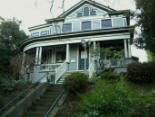
I doubt if any other neighborhood in Portland has the variety of homes that exist in the South Portland community. There are new high-rise riverfront condos, historic homes, new townhomes, apartment buildings, and newer detached single-family homes. The first homes, built in the 1870s, were mostly Victorian and home to workers at nearby docks, warehouses, and riverside industries.
The terrain is flat along the river and starts rising just west of Macadam Avenue so many of the homes in the hills have views of the river and Cascade Mountain range. The same holds true for the high rise condos along the river, especially those in South Waterfront.
Affordable? Condos can be found in the $200s and townhomes for just over 300,000.
The South Portland Historic District was added to the National Register of Historic Places in 1998. The district is roughly bounded by Arthur, Front, Grover, Hood, and Curry Streets, and Barbur Boulevard. It has 186 buildings in the 490-acre historic district. Styles include late 19th and early 20th Century American Movements as well as Victorian.
Portland Monthly Magazine Guide to Neighborhoods
 In their April issue every year, the Portland Monthly Magazine features the past year home prices along with other information about Portland neighborhoods and suburban communities. To read the magazine’s latest stories and numbers visit the Real Estate section.
The numbers on the website and the printed magazine are divided into four sections (real estate, people, crime, and lifestyle) on each of the Portland 90 plus neighborhoods as well as about 25 suburban communities. The website offers over 50 items of information about each Portland neighborhood and suburban community.
The magazine added a feature on their website for homes sold in 2014 and it’s also available for homes sold in 2015 — an interactive map where you can click on a neighborhood and a pop-up displays five items (1-year median price change, 5-year median price change, median gross rent, walkability score and percent of newcomer) for a Portland neighborhood as well as a suburban community. Note the detailed numbers for each of the four sections for homes sold in 2015 are displayed below the map.
To visit the magazine’s website latest stories and numbers visit their Real Estate section — click on “Neighborhoods” to view the numbers for the Portland neighborhoods and click on “Suburbs” for the numbers on communities in the metro area. Note the detailed numbers for each of the four sections for homes sold in 2014 and 2015 are displayed below the map. To access the Portland neighborhoods and metro communities demographic data and home prices by year:
- 2014 Demographics and Home Prices
- 2015 Demographics and Home Prices
- 2016 Demographics and Home Prices
South Portland Demographics Below are some facts about the South Portland neighborhood gleaned from the magazine’s website. A few numbers can tell much about the character of a neighborhood. You can view more data about South Portland by visiting the Portland Monthly’s website.
- Average year homes built in the neighborhood: 1985
- Percent of residents below poverty level: 13.3%
- Percent of neighborhood size with parks: 6%
- Percent of residents that live within a 1/2 mile of a park: 84%
- Commute by bike or walking: 17.2%
1South Portland Home Prices: 2007-2016
- Number of Homes Sold in South Portland—► 197 homes were sold in 2016 and 1% were distressed sales. 217 homes were sold in 2015 and 2.8% were distressed sales. 198 homes were sold in 2014 and 86% of the sales were condos — 5% were distressed property sales. 227 homes were sold in 2013 and 7% were distressed sales. 22 homes were sold in 2012 and 21% were distressed sales. 177 homes were sold in 2011 and 33% were distressed sales. In 2010 there were 229 home sold and 14% were distressed sales.
- Median Price for Homes Sold in South Portland—► $425,000 in 2016, $385,000 in 2015, $359,950 in 2014, $356,300 in 2013, $335,000 in 2012, $275,000 in 2011, $305,000 in 2010, $299,500 in 2009, $373,000 in 2008, and $349,000 in 2007.
- Average Cost per Square Foot—► $335 in 2016, $297 in 2015, $272 in 2014.
- 1-year Median Sales Price Change—► The change was 9% in 2016. The change was 7% in 2015, 1% in 2014, 6% in 2013, 22% in 2012, -10% in 2011, and -1% in 2010.
- 5-year Median Sales Price Change in South Portland—► 26% change for the years 20112-2016. 40% change for the years 20111-2015. 2010 to 2014 the change was -8%. 2009 to 2013 the change was -9%. 2008 to 2012 the sales price change was -14%. 2007 to 2011 the sales price change was -24%. 2006 to 2010 the sales price change was -19%.
- Metro Area Median Home Price—► $395,000 in 2016, $308,000 in 2015, $288,500 in 2014, $265,000 in 2013, $235,000 in 2012, $221,000 in 2011, $239,900 in 2010, $247,000 in 2009, $278,000 in 2008, and $290,000 in 2007.
- Metro Area Average Home Price—► $347,000 in 2016, $354,500 in 2015, $333,000 in 2014, $310,600 in 2013, $275,000 in 2012, $263,300 in 2011, $282,100 in 2010, $289,900 in 2009, $330,300 in 2008, and $342,000 in 2007.
Please be aware that the above figures are subject to error and are intended as guidelines only. Visit the Portland Monthly Magazine website for an in-depth analysis of home prices in the Portland metro area.
Find a Home in the South Portland Neighborhood
- Homes for Sale in the South Portland Neighborhood — View on all devices except Apple® mobile devices. To view homes for sale in the South Portland neighborhood on Apple® mobile devices key in “South Portland” in the “Location” field and click on the “Search Now” icon.
- Display Homes for Sale in the South Portland Neighborhood — View on all devices. Photos of homes displayed along with detailed description of property.
- Search for Homes — Search on all devices. Map-based on devices configured with Adobe Flash and Javascript and text-based on any device.
Note in the second option above (mobile device) that the neighborhood will not display “South Portland” but rather “Corbett/Lair Hill” as this is one of the many names that the neighborhood is called. Homes displayed for sale are all in the “South Portland” neighborhood.
Homes for Sale in South Portland
455 Sw Hamilton Ct #603 Portland, OR 97239

6134 Sw Riverpoint Ln Portland, OR 97239

3601 Sw River Pkwy #2905 Portland, OR 97239

3570 Sw River Pkwy #2401 Portland, OR 97239

7006 Sw Virginia Ave Portland, OR 97219

3601 Sw River Pkwy #415 Portland, OR 97239

414 Sw Nevada St Portland, OR 97219

227 Sw Florida St Portland, OR 97219

6910 Sw Corbett Ave Portland, OR 97219

841 Sw Gaines St #305 Portland, OR 97239

7543 Sw Fulton Park Blvd Portland, OR 97219

4625 Sw Water Ave Portland, OR 97239

3570 Sw River Pkwy #513 Portland, OR 97239

841 Sw Gaines St ##1500 Portland, OR 97239

7515 Sw Corbett Ave Portland, OR 97219

836 Sw Curry St #508 Portland, OR 97239

239 Sw Hamilton St Portland, OR 97239

3601 Sw River Pkwy #401 Portland, OR 97239

3601 Sw River Pkwy #403 Portland, OR 97239

841 Sw Gaines St ##209 Portland, OR 97239

307 Sw Hamilton St Portland, OR 97239

815 Sw Pennoyer St Portland, OR 97239

415 Sw Florida St Portland, OR 97219

133 Sw Gibbs St #12 Portland, OR 97239

115 Sw Bancroft St Portland, OR 97239

3232 Sw 2nd Ave #8 Portland, OR 97239

3230 Sw 2nd Ave Portland, OR 97239

6014 Sw View Point Ter Portland, OR 97239

7230 Sw Virginia Ave Portland, OR 97219

7140 Sw Virginia Ave Portland, OR 97219

Parks in the South Portland Neighborhood
The neighborhood has a park for just about every need. The 3.24 acre Lark Hill Park (SW 2nd Avenue and Woods Street) was given to the city by Multnomah County in 1927. It includes a play area, paved paths, picnic tables, playground, and lighted tennis court. The play area has an engineered mulch surface and there is a rubberized surface on the merry-go-round so it can be used by the disabled.
Two buildings of historical interest are located in the park.The main building was constructed out of brick in 1918 in the Modified Georgian Revival style. In 1942, the State Architect’s Office extensively remodeled it to serve as the Youth Administration of the Federal Security Agency. In 1949, the Park Bureau created a Junior Museum in the building, later renamed the Children’s Museum, until it was relocated to the former OMSI building in Washington Park in 2001.
The smaller building, the Customs House, was built in 1921 as a branch of the county library. The building, Italian Renaissance Revival, is one of seven Carnegie-funded branch libraries in Portland. It was designed by Folger Johnson, of Johnson & Wallwork, who designed four of the seven Portland Carnegie branches. The prominent arched windows and the curved entrance flanked by columns are typical of Italian Renaissance style. On the interior, a broken pediment appears below the circular window and Corinthian columns flank the wings. The library housed a collection of books in Yiddish, German, Polish, and Italian, as well as English before being converted to an art center by the Park Bureau in the early 1950s. Today the building is used as office space for PP&R staff.
At the west end of the park, a sculpture of metal boulders by Bruce West represents a rock grotto which once stood in the park and provided a shady place where older men gathered on hot summer days to play chess. It was installed in 1978 and is entitled simply BW1.
The Elizabeth Caruthers Park is located in the South Waterfront community and the 2.12-acre park was acquired in 2009. It includes a bocce court, paths, splash pad, and statue or public art. The park is named for Elizabeth Caruthers, an early pioneer woman who was one of the first settlers in the southern part of the young city of Portland. Elizabeth Caruthers was born in Tennessee. In 1816 she married Joe Thomas, and the couple had one son. She later rejected her married name, and in 1847 she and the son, Finice Caruthers, came to Oregon. They settled here on the banks of the river near the abandoned 1842 Johnson cabin. Under the Donation Land Claim Act of 1850, they claimed this 640-acre section. Elizabeth died in 1857 and Finice in 1860. Their deaths, without wills or heirs, led to fraudulent claims and litigation, which reached the United States Supreme Court in 1868. There the matter was resolved in a landmark decision ruling that, under the 1850 Donation Act, a woman — married or not — had the same property rights as a man.
Here are two parks located on the Willamette River:
- Willamette Park is located at the south end of the neighborhood along the Willamette River on 26.85 acres. The attractions are a boat dock/boat ramp, dog off-leash area, soccer field, children’s play area, and tennis courts. Nearby features include segments of the Willamette River Greenway Trail and the adjacent Willamette Butterfly Park, and the historic Lair Hill neighborhood.
- Butterfly Park is a one-acre undeveloped Willamette River shoreline, along the Willamette Greenway. It’s a good example of the natural environment of the river. Many cottonwood trees grow in the wet soil, while different species of birds, insects, and native plants flourish in this nature sanctuary. The park was named ‘Butterfly’ for its importance as a habitat for butterflies.
In the 90s, volunteers organized by the neighborhood association started meeting every so often on weekends to pull invasive plants out of Butterfly Park. That project has mushroomed to include a much-expanded area and many partners.
South Portland has 63 acres of parkland and open spaces according to Metro and the Portland Department of Parks and Recreation.
Willamette Greenway Trail
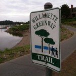
This trail is public that is on private land and runs along the Willamette River. Designed for bikers, runners, and walkers only – no motorized vehicles.
Maintained by the Johns Landing Homeowners Association, the trail is wide enough (eight feet in most places) to accommodate both bikers and walkers. Many bike commuters use the trail to travel back and forth to work downtown and at OHSU. It starts south of South Waterfront and ends at the Sellwood Bridge. Along the way are some marinas including the Willamette Sailing Club.
The river always holds some attractions such as waterfowl, sail boats, and you may even see an eagle. Trees along the river bank block views of the river along the northern part of the trail but once they shed their leaves in the fall, the river reappears.
Biking to Work in Portland
To bike from South Portland to downtown, you have two routes: Take the off-street (no motor vehicles) path along the river and then the painted bike lanes on SW Moody. The other choice is to take SW Barbur (painted bike lanes) into downtown. Download the SW Bikes Routes map for details. You can also use byCycle bicycle trip planner, a free online tool to help both new and seasoned cyclists plan safe trips through the city. This private website was created by cycling enthusiasts volunteering their time, with support from Metro.
Walking in South Portland
Two of the better walking tours in Portland is the Lair Hill Tour and the Historic South Portland tour. Below are links to the guides and a brief explanation of the tours:
- Lair Hill Tour The Lair Hill tour, includes a variety of interesting places to include a children’s museum, a couple of neighborhood homes, Lair Hill Park, and an Art Center.
- Historic South Portland This 4.7-mile self-guided walk explores historica South Portland, site of immigrant Jewish and Italian communities in the early 1900s, and then loops back along the Willamette River Greenway Trail and into the evolving South Waterfront District. Along the way are parks, beautiful 19th-century homes, quiet streets, and vies of Ross Island.
Laura Foster’s 3.25 mile “South Portland to South Waterfront Park Loop” is the ultimate walk if you want some exercise and history. Her 2008 book, Portland City Walks is Laura’s second book about walks. Her first book, Portland Hill Walks, is a treasure, and many of her fans thought she would never be able to equal that gem. But she did. Laura has three books about walking. Her Walk There! was published in June 2008 by Metro, the Portland-area regional government, and funded by Kaiser Permanente.
Walk Score helps you find a walkable place to live. Walk Score is a number between 0 and 100 that measures the walkability of any address. Portland is the 14th most walkable city in the U.S. with a Walk Score of 63, a Transit Score of 50 and a Bike Score of 72. There are over 3,000 restaurants and coffee shops in Portland. People in Portland can walk to an average of five restaurants and coffee shops in five minutes.
The Walk Score for the South Portland neighborhood is 55, the Transit Score is 61, and the Bike Score is 76.
South Portland
Somewhat Walkable
Walk Score®
55
out of 100
South Portland is the 51st most walkable neighborhood in Portland.

More About South Portland
Learn more about the South Portland neighborhood by visiting Portland Maps. The site offers a list of businesses, demographic data, crime stats, parks, schools, aerial photos, maps, elevation, and more for the South Portland neighborhood. All you need is a property address — use “836 SW Curry Street” or an address of your choice.
- Neighborhood Association Website South Portland represents South Waterfront, Corbett, Johns Landing, and Fulton neighborhoods. The neighborhood is often called Corbett-Terwilliger-Lair Hill. Visit the South Portland website to learn more about the 75 plus businesses in the neighborhood.
- Location South Portland is a long narrow neighborhood just south of downtown, hemmed in between the Willamette River and the West Hills. It stretches from I-405 and the Marquam Bridge on the north to SW Canby Street and the Sellwood Bridge in the south. The Willamette River forms the eastern boundary, and SW Barbur Boulevard most of the western boundary. South Waterfront is part of the neighborhood.
- South Portland Boundaries The neighborhood is a long, varied strip south of downtown, roughly from the Marquam to Sellwood bridges and from Barbur Boulevard (west boundary) to the Willamette River (east boundary).
- Map of Boundaries South Portland.
- 2Drive Time to Downtown A few minutes is you live on the north end but at least 10-11 minutes from the south end of the neighborhood.
- Topography lat with hills west of MacAdam. Mature trees.
- Sidewalks and Streets Grid pattern of streets with blocks that are very long or short. Most of the neighborhood has sidewalks – the exception being those closer to the river.
- Public Transportation TriMet has 25 bus routes through the neighborhood. There is a streetcar line located on the north end of the neighborhood in the South Waterfront area. The Tilikum Crossing bridge opened in 2015 and added capacity to the transportation system, with access to destinations such as PSU, OHSU, the Central Eastside and OMSI, while reducing commute pressure on other bridges. Bus Lines 9-Powell Blvd and 17-Holgate/Broadway use the new bridge, reducing their travel time and improving efficiency. The red, blue, and orange lines of MAX light rail also cross the bridge. The streetcar line also intersects with the MAX light rail tracks to make the area a busy place. Cyclists and pedestrians can access existing and planned greenways and bike routes on both sides of the river. Transit Score provides a 0-100 rating indicating how well an address is served by public transportation. Ratings range from “Rider’s Paradises” to areas with limited or no nearby public transportation.
- Commuting 15.9% of the neighborhood residents commute by public transportation, 3.9% by bike and 12.1% walk.
- 3Census 2010 Demographics Population: 6,631. Area size: 1,112 acres. Average population density: 5 persons per acre. Households: 4,500. The average size of household: 1.47 persons. Median household income: $64,836. Families with children: 13%. Percent of homeowners: 40%. Percent of renters: 60%. Diversity: 14.5 non-Caucasian. More census data about South Portland at Portland Online and City Data.
- 4Crime Stats There were 293 property crimes (assault, arson, burglary, larceny, robbery, theft from auto, vehicle theft) in 2014. There were 12 violent crimes (aggravated assault, homicide, robbery, rape) committed in 2014. There were 33 crimes per 1,000 residents in 2014. For the latest crime statistics and historical data for the South Portland neighborhood, visit the Portland Police Bureau website.
- Sex Offenders Click here for the State of Oregon Sex Offender Inquiry System. After agreeing to the “Conditions of Use Statement,” you will be redirected to an “Enter Search Criteria” page. Insert a zip code in the “Zip” field and click on the “Query” button. South Portland zip code(s): 97201, 97219, 97239.
- 4Shopping and Services Number of supermarkets: 1. Number of hardware stores: 0. Number of coffee shops: 2. Zupans, one of Portland locally owned food markets is located at 7221 SW Macadam Avenue. For a shopping change, take the one-mile drive on Taylors Ferry Road off Macadam Avenue to Market of Choice. Their meat counters are full of Oregon beef, pork, and lamb and the seafood are West Coast caught whenever possible. Also organic produce and many gluten-free items. Visit the South Portland website to learn more about the 75 plus businesses in the neighborhood.
- Eating Out Stores and restaurants from one end of the neighborhood to the other on SW Macadam Avenue. It’s about a ten-minute drive to the Sellwood area in southeast Portland where you can find even more choices.
- Public Library It’s about a ten-minute drive to the Sellwood-Moreland branch, or you can head downtown to the main one – see Multnomah County Central Library.
- Who Lives in South Portland Well over half of the residents possess a college degree. This means lots of white collar professionals, young married couples, and singles. They run, visit the health club, and eat at the numerous restaurants in the community including the Corbett Fish House where the fish and chips are gluten free. The median age is 36.
- Autos in the Neighborhoods Loads of practical foreign cars, Subaru Outbacks, and a couple of pickups and SUVs. No Caddies or Lincolns.
- 6Biking South Portland has 9.4 miles of bike lanes.