Guide to the Southwest Hills Neighborhood in Portland, Oregon
Portland Heights and Council Crest
Southwest Hills is a neighborhood in the West Hills (Tualatin Mountains) in the southwest section of Portland with an area of 1,926 acres and a population of 8,389 (2010 Census). Much of the western portion of the neighborhood lies outside of Portland city limits, in unincorporated Multnomah County. It is bordered by the Portland neighborhoods of Sylvan Highlands, Goose Hollow, Downtown, Homestead, Healy Heights, Bridlemile, and the Beaverton neighborhood of West Slope. Part of its northern border is Washington Park separated by Highway 26.
View a map of the Southwest Hills neighborhood.
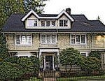
 Southwest Hills includes two well-known neighborhoods: Portland Heights and Council Crest. The northeastern part of the neighborhood, above Goose Hollow and Downtown Portland, is known as Portland Heights. Look into the west and slightly south from level ground in downtown and your eyes will be tilted upwards towards the hills of Portland Heights. Leaving downtown on West Burnside and heading south on Vista Avenue and after crossing the Vista Bridge (over Highway 26), you will notice stately homes like the one in the photo to the left. You’re in Portland Heights. Travel further southwest past the Ainsworth Elementary School and the next stop is the neighborhood of Council Crest.
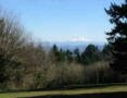
If you are familiar with Portland, you know what incredible views are afforded atop Council Crest. From Council Crest (on a clear day) you can see five snow-capped peaks and 3,000 square miles of land and rivers that connect them together.
History
This area is where John B. Talbot first claimed land in 1851. Although Portland Heights is one of the oldest and most exclusive neighborhoods in Portland mainly because of its views and closeness to downtown, the area did not develop until the early 1900s. It was just too difficult to navigate the muddy roads. Once the roads were paved and the Vista Bridge was built in 1903, land prices quickly went from a few hundred dollars an acre to $10,000 by 1910. The flatter area around the midpoint of Vista Avenue, known as “The Grid,” did attract residents to build summer cottages in the 1800s but those quickly disappeared and replaced by Colonials, Tudors, and other styles popular at the time when the area was developed.
The Portland Cable Railway started running a cable car up Vista Avenue to Council Crest Park in 1890. An amusement park was built on Council Crest in 1907 and continued operation until 1929. The city bought the land in 1936 and created Council Crest Park.
Origin of the Name of Council Crest
Council Crest got its name in 1898 from a group of delegates to a Congregational Church council who climbed the 1,073-foot hill and promptly named it after their gathering. Most likely the “Heights” in Portland Heights came about like all the other “Heights” names in the West Hills (e.g., Arlington Heights, King’s Heights, Willamette Heights, etc.). Or perhaps it was the fact that Portland Heights offered a view of the city of Portland from the “Heights.”
Schools in the Southwest Hills Neighborhood
Find your school attendance area or a school site and view the boundary area using School Locator. Read how to use the interactive map by clicking on the “Information” icon (circle with an “i” in the center).
- Schools in the Neighborhood A list of public and private schools in the Southwest Hills neighborhood.
- Public Schools in the Neighborhood Elementary school: Ainsworth. Middle school: East-West Sylvan. High school: Lincoln High School and Wilson High School.
- School Report Cards Report Cards for schools and districts in Oregon. Select “Portland SD 1J” to view individual schools within the Portland Public School District.
Southwest Hills Home Styles
Portland’s Everclear musical group has a song with the line, “I will buy you that big house, way up in the West Hills.” Everclear is from Portland and they are referring to the West Hills where Everclear’s founder Alexakis lived in the late 90s. He actually lived in Portland Heights. The song got it right because Portland Heights has big homes as well as some of the most sought after home in the metro area. Over the years, they have almost been recession-proof, offering owners a small but fairly consistent increase in value.
Southwest Hills homes have two attractions: downtown is only a short drive away and many of the homes have spectacular views. When you have a view of more than one mountain, such as Mt. Hood and St. Helens, it’s called a two-mountain view. When these homes go on the market, the ad reads, “mountain view during the day and city view at night.”
This charming Colonial in Portland Heights was built in 1916 and is one of the oldest homes on SW Sherwood Drive. It’s a good example of the type of home that can be found in the neighborhood. The main level welcomes you into a formal living room and beautiful dining room, both featuring grand fireplaces and quarter-sawn oak floors. The ‘green apple’ kitchen retains the old-house charm but was recently renovated with all the modern conveniences, including antiqued granite counter tops. From the downstairs basement to the top of the third floor, this very spacious and beautifully-designed home showcases a traditional style, updated to accommodate the needs of contemporary family life.
Portland Heights has a few condos whereas Council Crest is all detached single-family homes.
Portland Monthly Magazine Guide to Neighborhoods
 In their April issue every year, the Portland Monthly Magazine features the past year home prices along with other information about Portland neighborhoods and suburban communities. To read the magazine’s latest stories and numbers visit the Real Estate section.
The numbers on the website and the printed magazine are divided into four sections (real estate, people, crime, and lifestyle) on each of the Portland 90 plus neighborhoods as well as about 25 suburban communities. The website offers over 50 items of information about each Portland neighborhood and suburban community.
The magazine added a feature on their website for homes sold in 2014 and it’s also available for homes sold in 2015 — an interactive map where you can click on a neighborhood and a pop-up displays five items (1-year median price change, 5-year median price change, median gross rent, walkability score and percent of newcomer) for a Portland neighborhood as well as a suburban community. Note the detailed numbers for each of the four sections for homes sold in 2015 are displayed below the map.
To visit the magazine’s website latest stories and numbers visit their Real Estate section — click on “Neighborhoods” to view the numbers for the Portland neighborhoods and click on “Suburbs” for the numbers on communities in the metro area. Note the detailed numbers for each of the four sections for homes sold in 2014 and 2015 are displayed below the map. To access the Portland neighborhoods and metro communities demographic data and home prices by year:
- 2013 Demographics and Home Prices
- 2014 Demographics and Home Prices
- 2015 Demographics and Home Prices
Southwest Hills Demographics Below are some facts about the Southwest Hills neighborhood gleaned from the magazine’s website. A few numbers can tell much about the character of a neighborhood. You can view more data about Southwest Hills by visiting the Portland Monthly’s website.
- Average year homes built in the neighborhood: 1948
- Percent of residents below poverty level: 11.2%
- Percent of neighborhood size with parks: 14%
- Live within a 1/2 mile of a park: 83%
- Commute by bike or walking: 15.5%
1Southwest Hills Home Prices: 2007-2015
- Number of Homes Sold in Southwest Hills—► 126 homes sold in 2016 and 1% were distressed sales. 117 homes sold in 2014 and 15% 172 homes sold in 2015 and 5.8% were distressed sales. 117 homes sold in 2014 and 15% of the sales were for condos — 2% were distressed property sales. 154 homes were sold in 2013 and 3% were distressed sales. 134 homes sold in 2012 and 9% were distressed sales. 105 homes sold in 2010 and 7% were distress sales.
- Median Price for Homes Sold in Southwest Hills—► $784,450 in 2016, $699,000 in 2015, $640,000 in 2014, $620,000 in 2013, $525,000 in 2012, $560,000 in 2011, $560,000 in 2010, $635,000 in 2009, $644,500 in 2008, and $755,000 in 2007.
- Average Cost per Square Foot—► $292 in 2016, $255 in 2015, $237 in 2014.
- 1-Year Median Sales Price Change for Southwest Hills—► 2016 the sales price change was 14%. 2015 the sales price change was 9.2%. 2014 the change was 3%. 2013 the change was 18%. 2012 the sales price change was -6%. 2010 the sales price change was -3%.
- 5-Year Median Sales Price Change in Southwest Hills—► 49% change for the years 2012-2016. 25.5% change for the years 2011-2015. 2010 to 2014 the sales price change was 7%. 2009 to 2013 the sales price change was 4%. 2008 to 2012 the sales price change was -12%. 2006 to 2010 the change was -6%.
- Portland Metro Area Median Home Price—► $395,000 in 2016, $308,000 in 2015, $285,500 in 2014, $265,000 in 2013, $235,000 in 2012, $221,000 in 2011, $239,900 in 2010, $247,000 in 2009, $278,000 in 2008, and $290,000 in 2007.
- Portland Metro Area Average Home Price—► $347,000 in 2016, $354,500 in 2015, $333,000 in 2014, $310,600 in 2013, $275,000 in 2012, $263,300 in 2011, $282,100 in 2010, $289,900 in 2009, $330,300 in 2008, and $342,000 in 2007.
Please be aware that the above figures are subject to error and are intended as guidelines only.
Find a Home in Southwest Hills (Portland Heights and Council Crest)
- Homes for Sale in the Southwest Hills Neighborhood —View on all devices except Apple® mobile devices. To view homes for sale in Southwest Hills on Apple® mobile devices key in “Southwest Hills” in the “Location” field and click on the “Search Now” icon.
- Displays Homes for Sale in the Southwest Hills Neighborhood — View on all devices. Photos of home displayed along with detailed description of the property.
- Search for Homes — Search on all devices. Map-based on devices configured with Adobe Flash and Javascript and text-based on any device.
Homes for Sale in Southwest Hills
4311 Sw Greenleaf Dr Portland, OR 97221

2896 Sw Patton Rd Portland, OR 97201

2629 Sw Buena Vista Dr Portland, OR 97201

1680 Sw Montgomery Dr Portland, OR 97201

1961 Sw Vista Ave Portland, OR 97201

2105 Sw Clifton St Portland, OR 97201

3528 Sw Gale Ave Portland, OR 97239

4465 Sw Greenleaf Dr Portland, OR 97221

1825 Sw Vista Ave Portland, OR 97201

5535 Sw Hewett Blvd Portland, OR 97221

1812 Sw Myrtle St Portland, OR 97201

2650 Sw Cross Ave Portland, OR 97201

4633 Sw Hillside Dr Portland, OR 97221

2643 Sw Buena Vista Dr Portland, OR 97201

3434 Sw Talbot Rd Portland, OR 97201

2611 Sw Ravensview Dr Portland, OR 97201

4633 Sw Hillside Dr Portland, OR 97221

4506 Sw Ormandy Way Portland, OR 97221

2642 Sw Chelmsford Ave Portland, OR 97201

6106 Sw Woods Ct Portland, OR 97221

4512 Sw Ormandy Way Portland, OR 97221

3209 Sw Talbot Rd Portland, OR 97201

3834 Sw Greenleaf Dr Portland, OR 97221

1702 Sw Vista Ave Portland, OR 97201

4426 Sw Hillside Dr Portland, OR 97221

3150 Sw 48th Ave Portland, OR 97221

4039 Sw Council Crest Dr Portland, OR 97239

4032 Sw Hewett Blvd Portland, OR 97221

4334 Sw Greenhills Way Portland, OR 97221

5005 Sw Humphrey Park Rd Portland, OR 97221

Parks in the Neighborhood
The neighborhood has four parks. Here’s a rundown on each:
- Governor’s Park This 5.41-acre park is for walking. It’s located at SW 13th Ave & Davenport Street and has some interesting history. The park got its name (Governor’s Park) when Sylvester Pennoyer, Governor of Oregon (1894-1901), gave the city the 5.3 acres. Pennoyer was the first person to make a gift of property to the city of Portland for solely park purposes.
- Marquam Nature Park The park is a linear trail that starts south of downtown at the foot of the West Hills. It supports an abundance of native plant species, and has several trails that wind up the hill and through trees such as Douglas fir, Western hemlock, Red cedar, and Bigleaf maples.
- Portland Heights Park The 5.3-acre park at SW Patton Road & Old Orchard Road includes a basketball court, paths, picnic tables, playground, soccer field, softball field, and tennis court.
The “crown jewel” of the Council Crest neighborhood is the 43-acre Council Crest Park. It includes a dog off-leash area, paths, picnic tables, statue or public art, vista point, and wedding site.
In July 1956, a welded, sheet bronze drinking fountain featuring a mother and child was installed in the park. Sculpted by Frederic Littmann, an associate professor of art at Portland State College, it has been mistakenly identified as a pioneer woman. The sculptor said the statue did not represent a particular era; it was simply a mother and child playing in the park and depicts joy. The photo at the top of this page is the pioneer woman.
Council Crest Park is one of the highest points in the metro area at 1,071 feet above sea level. On a clear day, the view from Council Crest is unbeatable. You can view many of the highest peaks in the Cascade Range. From the top of the hill, one can see five mountains in the Cascade Range: Mt. Hood, Mt. St. Helens, Mt. Adams, Mt. Jefferson, and Mt. Rainier (100 miles to the north). In addition, the park boasts a fantastic 180-degree view of Portland and surrounding towns.
Southwest Hills has 164 acres of parkland and open spaces according to Metro and the Portland Department of Parks and Recreation.
Cable Cars
The Portland Heights trestle opened in 1890 and paved the way for people to live in the Southwest Hills neighborhood. The trestle went all the way up to SW Spring Street which begins by the Ainsworth Elementary School.
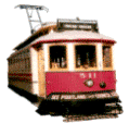
A streetcar line to the top of Council Crest was completed in 1906. It was the most scenic and spectacular streetcar line in the Northwest because once at the top, you have views of the Cascade Mountain Range. The photo to the left is one of the streetcars. The ‘cow catcher’ (aka a bumper) in front of the car reads, “See Portland from Council Crest.”
Walking in the Southwest Hills Neighborhood
Here are two walks in the neighborhood.
- This 5.6-mile Portland Heights to the Oregon Zoo walk combines stunning views of downtown and the Cascades, 19th-century homes, wooded paths and a ride on Portland’s only subway. Stop for a snack at Strohecker’s Grocery on your way to an afternoon visiting the Oregon Zoo. Click here to download the guide.
- The SW Trails Group is a committee of Southwest Neighborhoods Inc that uses volunteer efforts to make trail improvements, lead walks, work with Safe Routes to School, plan and advocate for pedestrian and bicycle safety and other improvements in SW Portland Their walks are the second Saturday of each month, meet at 9 a.m. sharp under the Hillsdale Oak, behind the Dance Studio at SW Sunset Blvd and SW Capitol Highway near the concrete bleachers of the Wilson football field.
Walk Score helps you find a walkable place to live. Walk Score is a number between 0 and 100 that measures the walkability of any address. Portland is the 14th most walkable city in the U.S. with a Walk Score of 63, a Transit Score of 50 and a Bike Score of 72. There are over 3,000 restaurants and coffee shops in Portland. People in Portland can walk to an average of five restaurants and coffee shops in five minutes.
The Walk Score for the Southwest Hills neighborhood is 31, the Transit Score is 47, and the Bike Score is 39.
Southwest Hills
Car-Dependent
Walk Score®
31
out of 100
Southwest Hills is the 76th most walkable neighborhood in Portland.

More About Southwest Hills
Learn more about the Southwest Hills neighborhood by visiting Portland Maps. The site provides a list of businesses, demographic data, crime stats, parks, schools, aerial photos, maps, elevation, and more for the Southwest Hills neighborhood. All you need is a property address — use “3574 SW Council Crest Drive” or an address of your choice.
- Southwest Hills Neighborhood Association Southwest Hills. For more information on all of the 17 Southwest neighborhoods visit the Southwest Neighborhoods website.
- Location of Neighborhood Southwest of downtown. Get on Southwest Vista and take a tour of the neighborhood. Take a historical tour of homes on Montgomery Avenue.
- Southwest Hills Boundaries North: Highway 26 (Sunset Highway). South: Southwest Patton Road on the west end and Southwest Broadway on the east. East: I-405. West: Southwest Scholls Ferry Road.
- Map of Southwest Hills Boundaries Southwest Hills.
- 2Drive Time to Downtown 12-13 minutes.
- Topography Moderate hilly in Portland Heights and quite hilly in Council Crest. Mature trees in yards in parks.
- Street and Sidewalks Many of the side streets are narrow. All of Portland Heights have walkable sidewalks whereas Council Crest has a few sidewalks.
- Public Transportation Five bus routes connect the Southwest Hills with the rest of Portland. See the Vista – 51 at the TriMet website. Two MAX light rail stops are located on the east edge of the neighborhood for the blue and red lines. Transit Score provides a 0-100 rating indicating how well an address is served by public transportation. Ratings range from “Rider’s Paradises” to areas with limited or no nearby public transportation.
- Commuting 3% of the neighborhood residents commute using public transportation, 2.2% bike, and 9.9% walk.
- 3Census 2010 Demographics Population: 8,389 persons. Size of Southwest Hills in acres: 1,926. Average population density: 6 persons per acre. Number of households: 3,946. Average size of household: 2.13 persons. Median household income: $100,121. Homeowners: 78%. Renters: 22%. Diversity: 8.4% non-Caucasian. More census data about Southwest Hills at Portland Online and City Data.
- 4Crime Stats There were 87 property crimes (assault, arson, burglary, larceny, robbery, theft from auto, vehicle theft) in 2014. There were three violent crimes (aggravated assault, homicide, robbery, rape) committed in 2014. There were 13 crimes per 1,000 residents in 2014. For the latest crime statistics and historical data for Portland neighborhoods, visit the Portland Police Bureau website.
- Sex Offenders Click here for the State of Oregon Sex Offender Inquiry System. After agreeing to the “Conditions of Use Statement” you will be redirected to an “Enter Search Criteria” page. Insert a zip code in the “Zip” field and click on the “Query” button. Southwest Hills zip code(s): 97201 and 97239.
- 5Shopping and Services Number of supermarkets: 0. Number of hardware stores: 0. Number of coffee shops: 0. Stroheckers, a landmark grocery store since 1902, closed in early 2016.
- Eating Out One restaurant and it’s worth a stop – the Vista Spring Cafe located at the intersection of SW Vista Street and SW Spring.
- Who Lives in the Southwest Hills Well established people especially in Portland Heights which has some of the most expensive housing in Portland. This is a white-collar neighborhood. The median age is 45. The median household income of $100,121 puts SW Hills in the number eight position for neighborhood highest incomes.
- Cars in the Neighborhood Expensive real estate so you’ll see expensive cars including Audis, BMWs, Mercedes, and other luxury autos along with a second car which is usually a SUV.
- 6Biking Southwest Hills has 1.5 miles of bike lanes.