| Subscribe to the Moving to Portland Newsletters |

Portland, Oregon


Guide to the Alameda Neighborhood in Portland, Oregon |
||||
|
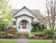
Alameda is a The Alameda Brewhouse is a favorite of the locals − try the Black Bear Stout Turkey Pot Pie served with vegetables and mushrooms slow simmered in their stout ale. You can also enjoy a hardy breakfast at the Alameda Cafe. Their menu includes waffles, bacon and eggs, and quiche. The Alameda Elementary (photo) is located at 2732 NE Freemont Street and was built in the early 1920s. History of AlamedaOn a high plateau above the city, the Alameda neighborhood sits on the 1859 land claim of William C. Bowering and his wife, Isabelle. The area became known as Gravelly Hill Road for a gravel pit at NE 33rd and Fremont. In 1909, the Alameda Land Company laid out the exclusive Alameda Park subdivision that was then added to the City of Portland. The Alameda History Web site is full of information about the neighborhood. The site is run by 'old house' researcher and Alameda neighborhood historian Doug Decker who is available to research your home, or to provide you with ideas and resources for you to do the research yourself. Doug is a contributing writer for the Alameda Newsletter and is always on the lookout for the next history story. Here's an excerpt from the Web site about the Broadway streetcar:
Origin of the Name AlamedaThe name comes from the Spanish word "alamo," meaning a poplar or cottonwood tree. "Alameda" means, precisely, a public walk or promenade lined with poplar trees, and, by extension, a street lined with trees. Like the English word for a "parkway." Alameda Home StylesEnglish Tudor, Queen Anne, and bungalows. Traveling north of Fremont, you will leave the symmetric grid-blocks and begin ascending in elevation and the streets start running at angles and some are circular. This hilly area is called the Alameda Ridge. Some of the homes on the ridge have commanding views of the West Hills, the Willamette River, and downtown. 1Alameda Home Prices
Please be aware that the above figures are subject to error and are intended as guidelines only. View Alameda homes currently for sale by clicking here. Parks in the NeighborhoodThe neighborhood does not have a park within in borders. Here are two parks on Alameda's borders:
The Matt Dishman Community Center is located at 77 NE Knott Street (about 1.5 miles from Alameda's east border) and includes a basketball court, fitness room, gymnasium, party room, a a indoor swimming pool, and weight room. Alameda does not have any park land and open spaces according to Metro and the Portland Department of Parks and Recreation. Walking in Alameda
Walk Score helps you find a walkable place to live. Walk Score is a number between 0 and 100 that measures the walkability of any address. Portland is the 12th most walkable city in the U.S. with a Walk Score of 66 and 57% of the residents have a Walk Score of 70 or above. The Alamada neighborhood ranks 47 out of 89 Portland neighborhoods. Below is a Walk Score for an address in the center of the neighborhood. More About Alameda
Map of the Alameda Neighborhood
Visit the Alameda Neighborhood via Google Earth
Coordinates Google Earth
_______________________________________________ 1Real Estate Values Data on real estate values provided by RMLStm. Distressed properties refer to the percentage of total homes sold that were short sales and bank-owned properties.2Drive Time to Downtown Estimated commuting time obtained from Yahoo Maps and Google Maps. Drive time was calculated from a central intersection in each neighborhood to Pioneer Courthouse Square during the morning peak commute time.3Demographics Data Numbers were obtained from Census 2010 and www.portlandmaps.com.4Crime Statistics Numbers on crime were obtained from Portland Police Bureau. Violent crimes are defined as murder, rape, robbery, and aggravated assault. Crimes per 1,000 are based on reported incidents of violent crime, as well as burglary, larceny, and motor vehicle theft.5Shopping and Services Numbers were determined from local directory listings and county/municipal library systems.6Biking Quality rating based on the 2007 Cycle Zone Analysis conducted by the City of Portland Office of Transportation. The six-tier ratings have been reduced to three levels: High, Fair, and Low.7School Report Card Grades Schools ratings from the Oregon Department of Education 2009-2010 performance assessment. "O" = Outstanding; "S" = Satisfactory; "I" = In Need of Improvement; NR = Not Rated.
|
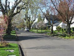
 neighborhood in Northeast Portland, Oregon centered around the cross-streets of NE Fremont and 33rd Avenue. It's a neighborhood where you will find tree-lined streets, older architecturally significant and view homes, neighborhood shops, coffee places, and high level of community involvement.

Guide to the Beaumont-Wilshire Neighborhood in Portland, Oregon
 Beaumont-Wilshire is an older, established neighborhood. It has a mixture of residential and commercial properties. The Beaumont-Wilshire neighborhood is in actuality two separate neighborhoods separated by NE Fremont Street, with Beaumont to the south and Wilshire to the north. The two neighborhoods agreed to form the Beaumont-Wilshire Neighborhood Association to recognize their common interests, including their common commercial center of Beaumont Village.
"Beaumont Village, located on NE Fremont Street, from NE 33rd Avenue to NE 50th Avenue, is the main commercial district in the neighborhood, but the neighborhood also lies within walking distance of the Hollywood District, a major commercial and shopping area to the south. Urban Spoon lists 18 eating places on NE Fremont between NE 41st and NE 52nd Avenues.
The Beaumont-Wilshire neighborhood has a variety of home styles. South of Fremont, most of the homes were built in the early 1900s and you will find Tudors, Craftsman, bungalows, etc. Once you cross Fremont heading north, you'll find early 1900s classic styles along with a few homes that were built after 1950.
A favorite store for the neighborhood shoppers is the 5,000 square foot Beaumont Market at 4130 NE Fremont Street. In addition to the grocery items, there is an amazing amount of other stuff. Look up as it goes all the way from the floor to the ceiling, including some things hanging from the ceiling. You can always find a last minute gift item somewhere in Beaumont. They carry a good quantity of wine as well as the Harris Ranch meats and fresh produce.
History of Beaumont-Wilshire
The original Beaumont neighborhood was platted in 1910. It was original part of the Rose City Park subdivision which was platted in 1907. The original Rose City Park subdivision was part of a 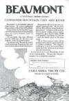 land claim of Joseph Backenstos, which was assigned to his widow by President Andrew Johnson in 1866. Early maps, around 1890, refer to this area as the Crook Tract. The south slope of Alameda Ridge, originally known as "Beaumont Hill" or "Gravel Hill", trends northwest-southeast through the southern part of the neighborhood. The ridge provides spectacular views of northeast Portland and the downtown skyline, and boasts some of the most expensive homes in Portland. Reportedly, concrete sidewalks and curbs were poured south of NE Fremont in 1911, and the streets were paved within the following few years.
The Wilshire neighborhood was initially platted in 1921 around the area of NE 33rd and N.E. Skidmore. In 1928 the area between NE Fremont and Prescott, and from NE 42nd to 52nd was annexed into the city of Portland, and part of this annex later became the eastern part of the Wilshire neighborhood.
You will want to read the flyer above (just click on it) put out by the Columbia Trust Company in 1910 promoting Beaumont The language of the ads is very flowery as the first paragraph reads, "Beaumont is a veritable natural observatory. It is the residential observatory of the City of Portland." The last paragraph of the ads invites you and your friends to see Beaumont in "one of our automobiles."
Origin of the Names: Beaumont and Wilshire
Beaumont is the subdivision created in 1910. It means "beautiful mountain" in French. The neighborhood is slightly elevated and the developers wanted to call attention to that desirable feature. The Wilshire subdivision was platted in 1921 around the area of NE 33rd and NE Skidmore.
Beaumont-Wilshire Home Styles
Bungalow, English, and Tudors south of NE Fremont. Some post WWII (ranch style, etc.) north of Fremont.
Neighborhood Web Site and Blog
The Beaumont-Wilshire Neighborhood Association Web site is full of information and photos. It a must visit and by all means, read their newsletters and look at the annual picnic photos. You may also want to visit the Beaumont-Hollywood blog.
1Beaumont-Wilshire Home Prices
- Number of Homes Sold in Beaumont-Wilshire—► 93 homes were sold in 2011 and 10% were distressed sales. In 2010 there were 97 and distressed properties sales were 7%.
- Average Price for Homes Sold in Beaumont-Wilshire—► $394,091 in 2011.
- Median Price for Homes Sold in Beaumont-Wilshire—► $356,556 in 2011, $365,000 in 2010, $366,000 in 2009, $405,000 in 2008, and $399,750 in 2007.
- 1-Year Median Sales Price Change in Beaumont-Wilshire—► 2011 the sales price change was -2%. 2010 the sales price change was -1%.
- 5-Year Median Sales Price Change in Beaumont-Wilshire—► 2007-2011 the sales price change was -10%. 2006-2010 the sales price change was -4%.
- Portland Metro Area Median Home Price—► $221,000 in 2011, $239,900 in 2010, $247,000 in 2009, $278,000 in 2008, and $290,000 in 2007.
- Portland Metro Area Average Home Price—► $263,300 in 2011, $282,100 in 2010, $289,900 in 2009, $330,300 in 2008, and $342,000 in 2007.
Please be aware that the above figures are subject to error and are intended as guidelines only. View Wilshire homes currently for sale by clicking here. View Beaumont homes currently for sale by clicking here.
Parks in the Neighborhood
Wilshire Park is located on the neighborhood northeast border. The 14.40 acre park includes a picnic area, restroom, dog off-leash area, horseshoe pit, paths, playground, soccer field, softball field, volleyball court, and wading pool or splash pad.
The Matt Dishman Community Center is located at 77 NE Knott Street (about 1.5 miles from Alameda's east border) and includes a basketball court, fitness room, gymnasium, party room, a a indoor swimming pool, and weight room.
Beaumont-Wilshire has 14 acres of park land and open spaces according to Metro and the Portland Department of Parks and Recreation.
Walking in Beaumont-Wilshire
You can walk anywhere in the neighborhood and enjoy the trees, homes, and shops along NE Fremont Street. Laura Foster's Portland City Walks book is available from Timber Press here in Portland. The book has a 5.8 mile walk which takes you on NE Fremont Street along the Rose City Cemetery.
Walk Score helps you find a walkable place to live. Walk Score is a number between 0 and 100 that measures the walkability of any address. The Beaumont-Willshire neighborhood ranks 36 out of 89 Portland neighborhoods. Below is a Walk Score for an address in the center of the neighborhood.
More About Beaumont-Wilshire
- Neighborhood Association Web Site Beaumont-Wilshire.
- Location From downtown cross over the Willamette River on the Broadway Bridge and head north on NE Broadway. Take a left on Martin Luther King, Jr. Boulevard. Turn right on NE Fremont Street - when you arrive at NE 33rd Avenue look right or left and you're in Beaumont-Wilshire.
- Topography Hilly on the Alameda ridge on the south edge of the neighborhood. Mature trees and wooded parks.
- Sidewalks and Streets The street pattern is a grid in the north part and some winding streets on the south edge of the neighborhood along the Alameda Ridge. The neighborhood has sidewalks for walking.
- Livability Study 95.3% of Beaumont-Wilshire residents rated their neighborhood "good" or "very good." See Livability Study.
- 2Drive Time to Downtown 12-13 minutes by car.
- Public Transportation TriMet has three bus routes in Beaumont-Wilshire. The Northeast schedule and routes can be found at TriMet Web site. No MAX light rail or streetcars in Beaumont-Wilshire. Transit Score provides a 0-100 rating indicating how well an address is served by public transportation. Ratings range from "Rider's Paradises" to areas with limited or no nearby public transportation.
- 3Census 2010 Demographics Population: 5,346 people. Area size in acres: 470. Average population density: 11 persons per acre. Number of households: 2,319. Average size of household: 2.31 persons. Median household income: $70,267. Families with children: 25.6%. Home owners: 85%. Renters: 15%. Diversity: 11.7% non-Caucasian. More census data for Beaumont-Wilshire at Portland Online.
- 4Crime Stats Six violent crimes and crimes per 1,000 people was 26 in 2011. Three violent crimes in 2010 and total crimes per 1,000 residents was 18. For the latest crime statistics for the Beaumont-Wilshire neighborhood, click here.
- 5Shopping and Services Number of food markets: 1. Number of health club: 1. Number of coffee shops: 1. The Beaumont Market on Northeast 41st Avenue and NE Fremont Street is a favorite of locals. Just a couple of blocks further east is the Beaumont "Do It Best Hardware." Click here to access a shopping guide/map of Beaumont.
- Eating Out Numerous choices along NE Fremont which is right in the middle of the neighborhood. Walking to a dining spot is possible for many residents. Visit Willamette Weeks' Restaurant Guide by Neighborhood for a list of eating places in Beaumont-Wilshire.
- Who Lives in Beaumont-Wilshire A cross section of people depending upon which side of the "tracks" you live on. The "tracks" is NE Fremont. The median age of a resident is 42.4 according to Census 2010..
- Autos in the Neighborhood American cars north of Fremont and value-packed vehicles south.
- 6Biking Quality is fair. Beaumont-Wilshire has six miles of bike lanes.
- Schools Elementary: Alameda PK-5 and Sabin PK-8. Middle: Beaumont 6-8 and Sabin PK-8. High school: Grant High School.
- 7School Report Card Grades Elementary schools: O/S. Middle school: O. High school: I. Click here for report card details.
Map of the Beaumont-Wilshire Neighborhood
Fly to the Beaumont-Wilshire-Neighborhood via Google Earth

Coordinates
45° 33′ 11.52″ N
122° 37′ 11.84″ W
Launch Google Earth
___________________________________
1Real Estate Values Data on real estate values provided by RMLStm. Distressed properties refer to the percentage of total homes sold that were short sales and bank-owned properties.
2Drive Time to Downtown Estimated commuting time obtained from Yahoo Maps and Google Maps. Drive time was calculated from a central intersection in each neighborhood to Pioneer Courthouse Square during the morning peak commute time.
3Demographics Data Numbers were obtained from Census 2010 and www.portlandmaps.com.
4Crime Statistics Numbers on crime were obtained from Portland Police Bureau. Violent crimes are defined as murder, rape, robbery, and aggravated assault. Crimes per 1,000 are based on reported incidents of violent crime, as well as burglary, larceny, and motor vehicle theft.
5Shopping and Services Numbers were determined from local directory listings and county/municipal library systems.
6Biking Quality rating based on the 2007 Cycle Zone Analysis conducted by the City of Portland Office of Transportation. The six-tier ratings have been reduced to three levels: High, Fair, and Low.
7School Report Card Grades Schools ratings from the Oregon Department of Education 2009-2010 performance assessment. "O" = Outstanding; "S" = Satisfactory; "I" = In Need of Improvement; NR = Not Rated.
View
|
Beaumont-Wilshire
|
To learn more about the
|
Learn More
|
Guide to the Concordia Neighborhood in Portland, Oregon
 If you like diversity, funky, and art, you'll love Concordia. Park your car and start walking along NE Alberta Street from NE 33rd Avenue heading west. Stop and browse at some of the dozen or so art galleries along the way. Note the complete absence of national chains and fast food outlets. When you get thirsty and hungry, stop off for lunch at one of the eating establishments along the street.
Now that you have seen Concordia, you will realized that this was a neighborhood in transition and it has turned the corner. You can find lots of historic homes (especially on the east side of the neighborhood boundary) that need some TLC.
New Seasons Market at Concordia has been recognized as a national business model for New Seasons approach to opening a business with the community's best interest in mind. When Portland's Concordia neighborhood voiced their need for a grocery store in 2000, New Seasons jumped at the chance, while other retailers second-guessed the store's location. New Seasons Market established relationships across cross-cultural barriers, attended neighborhood meetings and responded to the neighborhood's priorities. It's a store that's clean, friendly, and a pleasure to shop at. Try their Rocky natural chickens or the Oregon Beef. But the best is their Pacific Coast fish, always fresh and wild.
Community News Coverage
The Concordia News newspaper is a free, self-supporting, volunteer, monthly publication of the Concordia Neighborhood Association. It is without doubt one of best, if not the best, publication of any Portland neighborhoods. If you considering purchasing a home in Concordia, you will want a subscription. Contact The Concordia News at: P.O. Box 11194, Portland, Oregon 97211 or Jeff Hilber at This email address is being protected from spambots. You need JavaScript enabled to view it. .
The Portland Sentinel covers news for North Portland neighborhoods as well as those Northeast Portland neighborhoods along the boundary between the two areas such as Concordia, Eliot, King and Piedmont.
Alberta Street
Funky galleries, independently owned boutiques, coffee shops, and restaurants and all located in one of Portland’s most culturally diverse neighborhoods, with many African-American and Latino-owned businesses. That's Alberta Street. Alberta Street has many renovated retail storefronts that are mixed in with older businesses that have been there for years. Just a few years ago, you would be viewing many boarded up windows but today fresh paint and stylish logos are the trend.
Go virtual shopping on Alberta Street by downloading a shopping guide/map − just click here.
 Art on Alberta is a non-profit organization whose mission is to promote Alberta's Street distinct culture and identity through public art, visual art, and educational activities. They have sponsored a "Last Thursday" on Alberta Street since 1997. The event is held every month, year round. The galleries, studios, restaurants and other art venues on the street open their doors for a celebratory evening of art. Generally the galleries are open between 5 to 9:30 p.m. They publish a monthly Last Thursday walking map, which identifies the art activities, sponsored by Art on Alberta members. Download the current Art Map by clicking here.
History of Concordia
In the late 90s, the Alberta Street community was engaged in a planning process to make the street a better place to walk, ride a bike and use transit, while maintaining automobile access and parking. The plan was adopted by Portland's City Council in February 2000. Construction begin in April 2002 and was completed in late summer 2003. The project is building improvements between NE Martin Luther King Jr. and NE 33rd Avenue, including curb extensions at transit stops and key crossings, school crossing improvements, new ornamental street lighting and traffic signals, street trees and public art.
How the Neighborhood Got Its Name
This neighborhood is the home of Concordia University, a Lutheran liberal arts school.
Concordia Home Styles
This neighborhood has many historic homes, especially on the east side of the neighborhood which borders the Alameda neighborhood. It also has a few ranch homes. Most of the homes are small (under 1600 square feet) and on lots just under 5,000 to 7,000 square feet.
1Concordia Home Prices
- Number of Homes Sold in Concordia—► 117 homes sold in 2011 and 25% were distress sales. 138 homes sold in 2010 and distressed properties sales were 12%.
- Average Price for Homes Sold in Concordia—► $272,024 in 2011.
- Median Price for Homes Sold in Concordia—► $268,000 in 2011, $286,533 in 2010, $285,000 in 2009, $299,900 in 2008; and $340,300 in 2007.
- 1-Year Median Sales Price Change in Concordia—► 2011 the sales price change was -6%. 2010 the sales price change was 0%.
- 5-Year Median Sales Price Change in Concordia—► 2007 to 2011 the sales price change was -21%. 2006 to 2010 the sales change was -1%.
- Portland Metro Area Median Home Price—► $221,000 in 2011, $239,900 in 2010, $247,000 in 2009, $278,000 in 2008, and $290,000 in 2007.
- Portland Metro Area Average Home Price—► $263,300 in 2011, $282,100 in 2010, $289,900 in 2009, $330,300 in 2008, and $342,000 in 2007.
Please be aware that the above figures are subject to error and are intended as guidelines only. View Concordia homes currently for sale by clicking here.
Parks in the Neighborhood
 Fernhill Park, located at NE 37th and Ainsworth, is a 24.15 acre park. The park includes softball, baseball, football, and soccer fields, two tennis courts, volleyball court, horseshoe pit, playground, wading pool, picnic tables, and restrooms. There’s no better way to spend a summer evening than gathering with friends and family in Fernhill Park for music, dancing and family fun. The Fernhill Concert Series has been an unqualified success, offering high-quality entertainment to the neighborhood with five free concerts.
Another park on the west border of Concordia is the 16.70 acre Alberta Park (adjacent to Vernon Elementary School). Alberta Park includes softball and football/soccer fields, basketball court (covered), two tennis courts, playground, wading pool, picnic tables, trails, and restrooms.
Concordia has 29 acres of park land and open spaces according to Metro and the Portland Department of Parks and Recreation.
Walking in Concordia
Alberta Street runs through the center of the neighborhood and it is an excellent place to walk with it many art galleries and retail storefronts. It also has a number of restaurants and coffee shops. The small shops lining Alberta Street highlight handmade local designer clothing, imported gifts, and the Alberta art galleries and shops showcase some fine local work. You won't find a national chain on Alberta.
The Art on Alberta Web site has an Arts Walking Tour which you can download and print by clicking here.
Walk Score helps you find a walkable place to live. Walk Score is a number between 0 and 100 that measures the walkability of any address. Concordia is the #31 most walkable neighborhood in Portland. This neighborhood is 'Very Walkable' with an average Walk Score of 75. Below is a Walk Score for an address in the center of the Concordia neighborhood.
More About Concordia
- Neighborhood Association Web Site Concordia Neighborhood Association.
- Location Head north in I-5. Take the Highway 30/Lombard Street exit and head off to your right which is east. When you arrive at NE 22nd Avenue look right and you're in Concordia.
- Topography Flat with a traditional grid pattern of blocks. A good quantity of mature trees but it could use more.
- Sidewalks and Streets The street pattern is a grid with sidewalks for walking.
- Livability Study 90.8% of Concordia residents rated their neighborhood "good" or "very good." See Livability Study.
- 2Drive Time to Downtown 15-16 minutes by car.
- Public Transportation Concordia does not have access to MAX light rail or the streetcar line. It does have four bus routes in the neighborhood. See TriMet for schedules. Transit Score provides a 0-100 rating indicating how well an address is served by public transportation. Ratings range from "Rider's Paradises" to areas with limited or no nearby public transportation.
- 3Census 2010 Demographics Population: 9,550 people. Area size in acres: 853. Average population density: 11 persons per acre. Number of households: 4,001. Average size of household: 2.39 persons. Median household income: $50,549. Families with children: 20.3%. Home owners: 70.7%. Renters: 29.3%. Diversity: 27.7% non-Caucasian. More census data about Concordia at Portland Online.
- 4Crime Stats 28 violent crimes in 2011 and total crimes per 1,000 residents was 30. 24 violent crimes in 2010 and total crimes per 1,000 residents was 31. For the latest crime statistics for the Concordia neighborhood, click here.
- 5Shopping and Services Number of supermarkets: 1. Number of health clubs: 1. Number of coffee shops: 1. At NE 33rd Avenue between NE Killingworth and NE Alberta, sits one of the Portland area's locally owned food markets, Concordia New Seasons Market. Just a few blocks west of the Concordia border is a co-op food market located at 15th and NE Alberta. Alberta Street shopping guide/map by clicking here.
- Eating Out NE Alberta Street has a number of interesting restaurants and coffee shops and more are appearing every few months. The main attraction of the Concordia neighborhood would have to be the Kennedy School (5835 NE 42nd Avenue), where local beer, a movie theater, hotel rooms, a restaurant, a hot soaking pool and a music venue all come together under one large McMenamin’s-owned roof. The building is actually an old elementary school that has been renovated to fit the needs of the public. Another popular spot is the Concordia Ale House (3276 NE Killingsworth Street), where you can always find an impressive rotating list of tap microbrews. Travel and Leisure Magazine in 2010 named Random Order Coffeehouse & Bakery's vanilla salted caramel apple pie as one of the best in the nation. Visit Yelp for a list of the neighborhood restaurants.
- Public Library The closest branch library of the Multnomah County Library system is the Hollywood at 4040 N.E. Tillamook Street.
- Who Lives in Concordia Blue collar, gray collar, and white collars are increasing. Todd Haynes, filmmaker (2003 Oscar nominee for "Far from Heaven" purchased a home in Concordia in 2000. The median age of residents is 35.6 according to Census 2010.
- Autos in the Neighborhood Buicks, Olds, and pickups. Toyotas and Subarus are increasing.
- 6Biking Quality if fair. Concordia has 11 miles of bike lanes.
- Schools Elementary and Middle: Faubion PK-8 and Vernon PK-8. High school: Jefferson High School and Madison High School.
- 7School Report Card Grades Elementary schools: O/S. Middle school: O. High schools: I. Click here for report card details.
Map of the Concordia Neighborhood
Fly to the Concordia Neighborhood via Google Earth
Coordinates
45° 33′ 58.94″ N
122° 37′ 28.27″ W
___________________________________
1Real Estate Values Data on real estate values provided by RMLStm. Distressed properties refer to the percentage of total homes sold that were short sales and bank-owned properties.
2Drive Time to Downtown Estimated commuting time obtained from Yahoo Maps and Google Maps. Drive time was calculated from a central intersection in each neighborhood to Pioneer Courthouse Square during the morning peak commute time.
3Demographics Data Numbers were obtained from Census 2010 and www.portlandmaps.com.
4Crime Statistics Numbers on crime were obtained from Portland Police Bureau. Violent crimes are defined as murder, rape, robbery, and aggravated assault. Crimes per 1,000 are based on reported incidents of violent crime, as well as burglary, larceny, and motor vehicle theft.
5Shopping and Services Numbers were determined from local directory listings and county/municipal library systems.
6Biking Quality rating based on the 2007 Cycle Zone Analysis conducted by the City of Portland Office of Transportation. The six-tier ratings have been reduced to three levels: High, Fair, and Low.
7School Report Card Grades Schools ratings from the Oregon Department of Education 2009-2010 performance assessment. "O" = Outstanding; "S" = Satisfactory; "I" = In Need of Improvement; NR = Not Rated.
View
|
Concordia
|
|
Learn More
|
Guide to the Grant Park Neighborhood in Portland, Oregon
 The Grant Park is a family-friendly feel, with quiet, residential streets that are lined with comfortable family homes. Grant Park with large mature trees, sports facilities, playground, and off-leash dog area, is the social center of the neighborhood.
Grant Park abuts (and overlaps) the following neighborhoods: Irvington on the west, Sullivan's Gulch on the east, Alameda on the north, Hollywood on the east, Laurelhurst on the southeast, Beaumont-Wilshire on the northeast, and Rose City on the east.
The Grant Park Neighborhood Association (GPNA) Web site is where you can read the GPNA newsletter online. It is an eight page quarterly publication that is distributed to over 2,000 homes between NE Broadway and NE Knott and from NE 26th to NE 47th, with some overlap around the outside edges. It is full of information.
To see how the neighborhood fits in with the rest of the area, download a map of Northeast Portland.
History of Grant Park
Originally one of Portland's streetcar suburbs, Northeast Portland underwent a great building boom from 1890-1913. During that time, Northeast Broadway, one of the district's main thoroughfares, evolved naturally into a busy strip of restaurants and shops needed to support Portland's growing eastside population.
How the Neighborhood Got Its Name
After General Ulysses S. Grant, the 18th President of the U.S.A. Grant visited Portland three times, a rare thing for a president to do in the days before air travel or before rail travel was standardized and safe. Early in his military career, Grant was assigned to Fort Vancouver, where he made friends with many of Portland's politicians.
Grant Park Home Styles
Grant Park features classic style homes to Craftsman, cottage, Cape Cod, and bungalows. Most homes sell well above $400,000 and they retain their value as evidenced below by the 'Grant Park Home Prices.'
1Grant Park Home Prices
- Number of Homes Sold in Grant Park—► 46 homes were sold in 2011 and 4% were distressed sales. 53 homes were sold in 2010.
- Average Price for Homes Sold in Grant Park—► $510,202 in 2011.
- Median Price for Homes Sold in Grant Park—► $471,000 in 2011, $470,000 in 2010, $432,000 in 2009, $547,250 in 2008, and $505,000 in 2007.
- 1-Year Median Sales Price Change in Grant Park—► 2011 the sales price change was 0%. 2010 the sales price change was 9%.
- 5-Year Median Sales Price Change in Grant Park—► 2007 to 2011 the sales price change was -5% 2006 to 2010 the sales price change was 3%.
- Portland Metro Area Median Home Price—► $221,000 in 2011, $239,900 in 2010, $247,000 in 2009, $278,000 in 2008, and $290,000 in 2007.
- Portland Metro Area Average Home Price—► $263,300 in 2011, $282,100 in 2010, $289,900 in 2009, $330,300 in 2008, and $342,000 in 2007.
Please be aware that the above figures are subject to error and are intended as guidelines only. View Grant Park homes currently for sale by clicking here.
Parks and Community Centers in the Neighborhood
 Grant Park is located at NE 33rd Avenue and US Grant Place and it has close to 20 acres. It has a baseball field, basketball court, soccer field, softball field, tennis court, restroom, dog off-leash area, picnic site, picnic tables, wading pool, and playground. The park also has an outdoor pool, a 25-yard shallow pool with a kid slide and 25-yard deep pool, heated to 84 degrees. The water depths of the pool range from 2-8 feet.
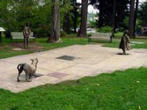
The Beverly Cleary Sculpture Garden at Grant Park celebrates author Beverly Cleary's colorful characters. the writer grew up in this neighborhood, and Grant Park is where her stories take place. Statues of Henry Higgins with his dog, Ribsy, and Ramona in her raingear stand around a central fountain. Lee Hunt, a local artist, designed the garden's child-friendly bronze sculptures.
The Beverly Cleary sculpture garden at Grant Park celebrates author Beverly Cleary's colorful characters. The writer grew up in this neighborhood, and Grant Park is where her stories take place. Statues of Henry Higgins with his dog, Ribsy, and Ramona in her raingear stand around a central fountain. Lee Hunt, a local artist, designed the garden's child-friendly bronze sculptures.
The Northeast Community Center (NECC) in Hollywood was started by a group of volunteers who formed a nonprofit, the NECC took over the building in 2008 that originally served as the Northeast YMCA for 80 years. The big yellow building just west of Starbucks was extensively renovated by volunteers and donors who wanted to save the facility and maintain its longtime heritage of service to the community. That heritage is now being expanded.
Grant Park has 19 acres of park land and open spaces according to Metro and the Portland Department of Parks and Recreation.
Walking in Grant Park
Walking in Grant Park means more than taking an evening stroll in the neighborhood. It means that you can walk to the library, restaurants, and even to food markets such as Trader's Joe over in the Hollywood area.
In the City of Portland 2005 Livability study, 94% of Grant Park residents rated their neighborhood "good" or "very good" on these two items: (1) Walking distance to bus stop and (2) Access to shopping and other services.
Here are two walks that are close to the Grant Park neighborhood:
- Alameda Ridge This 4.4-mile loop through Alameda includes a turnaround block at a 1927 mansion built by lumber baron Thomas Autzen. The walk's many stairs, beautiful homes and great views make it a fun adventure.
- Hollywood This is a short walk through the Hollywood neighborhood. It offers enough places to stop, shop, and eat that it can tak all day.
Walk Score helps you find a walkable place to live. Walk Score is a number between 0 and 100 that measures the walkability of any address. Portland is the 12th most walkable city in the U.S. with a Walk Score of 66 and 57% of the residents have a Walk Score of 70 or above.
The Grant Park neighborhood ranks 16 out of 89 Portland neighborhoods. Below is a Walk Score for an address in the center of the neighborhood.
More About Grant Park
- Neighborhood Association Web Site Grant Park.
- Location From downtown cross over the Willamette River on the Broadway Bridge and you'll head east on NE Weidler Street. Take a left on NE 26th Avenue. You'll be in the southwest corner of Grant Park.
- Topography Flat. Mature shade trees line every street in Grant Park.
- Sidewalks and Streets The street pattern is a grid with sidewalks for walking.
- Livability Study 96.8% of Grant Park residents rated their neighborhood "good" or "very good." See Livability Study.
- 2Drive Time to Downtown 12-13 minutes.
- Public Transportation Grant Park has three bus routes. The Northeast schedule and routes can be found at TriMet Web site. No MAX light rail or streetcars. Transit Score provides a 0-100 rating indicating how well an address is served by public transportation. Ratings range from "Rider's Paradises" to areas with limited or no nearby public transportation.
- 3Census 2010 Demographics Population: 3,937. Area in acres: 319. Average population density: 12 person per acre. Number of households: 1,534. Average size of household: 2.57 persons. Median household income: $78,291. Families with children: 29.1%. Home owners: 87.3%. Renters: 12.7%. Diversity: 9.1% non-Caucasian. More census data about Grant Park at Portland Online.
- 4Crime Stats Nine violent crimes and total crimes per 1,000 residents was 49 in 2011. Ten violent crimes and total crimes per 1,000 residents was 47 in 2010. For the latest crime statistics for the Grant Park neighborhood, click here.
- 5Shopping and Services Number of supermarkets: 1. Number of health clubs 0. Number of coffee shops: 0. Although there are a limited number of retail outlets in the neighborhood, residents are close to the Hollywood District which offers at variety of shopping opportunities.
- Farmers Market The Hollywood Farmers Market is held at Northeast Hancock Street between 44th and 45th Avenues. 8 am-1 pm Saturdays, May-November. More information at Hollywood Farmers Market.
- Eating Out Another reason is live in Grant Park is that you can walk over to the Hollywood District and dine at Sweet Basil Thai, the Blind Onion Pizza Pub, or a few others. Or head over to NE Fremont for even more places to eat. Visit Willamette Weeks' Restaurant Guide by Neighborhood for a list of eating places in Grant Park.
- Public Library The closest branch library of the Multnomah County Library system is the Hollywood at 4040 N.E. Tillamook Street.
- Who Lives in Grant Park Professionals! Who else could afford the home prices? The median age of a Grant Park resident is 42 according to Census 2010.
- Autos in the Neighborhood SUVs and luxury autos along with a handful of hybrids.
- 6Biking Qualify is fair. Grant Park has three miles of bike lanes.
- Schools Elementary and Middle: Beverly Cleary Hollywood Campus K-1 and Beverly Cleary Fernwood Campus 2-8. High school: Grant High School.
- 7School Report Card Grades Elementary schools: O. Middle schools: O. High school: I. Click here for report card details.
Map of the Grant Park Neighborhood
Fly to the Grant Park Neighborhood via Google Earth
Coordinates
45° 32′ 20.36″ N
122° 37′ 39.11″ W
Launch Google Earth
___________________________________
1Real Estate Values Data on real estate values provided by RMLStm. Distressed properties refer to the percentage of total homes sold that were short sales and bank-owned properties.
2Drive Time to Downtown Estimated commuting time obtained from Yahoo Maps and Google Maps. Drive time was calculated from a central intersection in each neighborhood to Pioneer Courthouse Square during the morning peak commute time.
3Demographics Data Numbers were obtained from Census 2010 and www.portlandmaps.com.
4Crime Statistics Numbers on crime were obtained from Portland Police Bureau. Violent crimes are defined as murder, rape, robbery, and aggravated assault. Crimes per 1,000 are based on reported incidents of violent crime, as well as burglary, larceny, and motor vehicle theft.
5Shopping and Services Numbers were determined from local directory listings and county/municipal library systems.
6Biking Quality rating based on the 2007 Cycle Zone Analysis conducted by the City of Portland Office of Transportation. The six-tier ratings have been reduced to three levels: High, Fair, and Low.
7School Report Card Grades Schools ratings from the Oregon Department of Education 2009-2010 performance assessment. "O" = Outstanding; "S" = Satisfactory; "I" = In Need of Improvement; NR = Not Rated.
|
View
|
Grant Park
|
|
Learn More
|
Guide to the Hollywood Neighborhood in Portland, Oregon
 The Hollywood neighborhood is a mix of commercial and residential space and provides shopping for many of the surrounding neighborhoods such as Grant Park and Laurelhurst, as well as to riders of the MAX Light Rail System. Hollywood also figures in Beverly Cleary's Klickitat Street series of books, a fact memorialized in a display at the neighborhood library. Details on a Beverly Cleary walking tour are available at the library.
Hollywood is conveniently located along major streets for easy commuting (NE Broadway and Sandy, plus a ramp to I-84). You can catch the flavor of the area by driving diagonally from southwest to northwest on NE Sandy Boulevard starting at NE 37th Avenue and you will exit the neighborhood on NE 47th Avenue.
The neighborhood has two markets (Trader Joe's and Whole Foods) along with a branch of the Multnomah County Library. With neighborhood shops, restaurants, a theater, and stores all within walking distance of most homes in the neighborhood.
Here are the Census 2000 numbers: 115 acres, just over 1,000 residents, 758 households, and 85% of Hollywood's residents are renters. Assuming that most of the renters live in apartment buildings, this means that the neighborhood has about 115 housing units that are owner occupied. In a typical year, only 10-15 homes are sold in the neighborhood.
The Hollywood Neighborhood Association (HNA) Web site is where you can get to know more about the neighborhood and read the HNS newsletter online.
To see how the neighborhood fits in with the rest of the area, download a map of Northeast Portland.
History of Hollywood
The Hollywood District was originally part of the Rose City Park subdivision which was platted in 1907. The original Rose City Park subdivision was part of the Donation Land Claim of Joseph Backenstos. The land was later assigned to his widow by President Andrew Johnson in 1866. 1890s-era maps refer to the area as the Crook Tract.
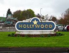
How the Neighborhood Got Its Name
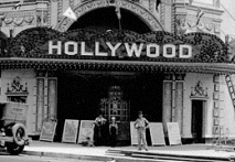 Originally called Hollyrood, after the Scottish Holyrood, it was renamed for its historic 1920s-era Hollywood Theater. Built in 1926 at the end of the silent-film era—sound was not successfully introduced until 1927—the Hollywood seated 1,500 viewers in a “palace of luxury, comfort and entertainment unsurpassed by any theater on the Coast,” according to an opening-day advertisement. While early theaters had been adapted from retail storefronts by unfurling a screen and setting up rows of chairs, the movie “palaces” that emerged in the 1920s were designed for the purpose, and they frequently used architecture to grab attention.
The Hollywood was designed by the architectural firm of Bennes & Herzog of Portland. The style has been described as “Byzantine,” but is better characterized as Spanish Colonial Revival. It was constructed of poured concrete, but the entrance was topped by an elaborate tower of polychrome (colored) terra cotta with arched niches flanked by turned pillars. The two-story street side of the theater was capped by roof tiles that carried out the Spanish Colonial theme. Most theaters of this size were located in downtown areas, but the Hollywood was sited in a neighborhood shopping district that was well served by both streetcar and automobile.
Hollywood Home Styles
Grant Park features classic style homes to Craftsman, Cottage, Cape Cod, and Bungalows. There are a number of condos in Hollywood, some new and others that have been converted from apartment buildings.
1Hollywood Home Prices
- Number of Homes Sold in Hollywood—► 12 homes were sold in 2011 and 17% were distressed sales. Four homes sold in 2010 and there were zero distressed properties sales.
- Median price for homes sold in Hollywood—► $269,550 in 2011, $397,500 in 2010, $375,800 in 2009, and $425,000 in 2008.
- 1-Year Median Sales Price Change in Hollywood—► 2011 the sales price change was -25%. 2010 the change was 7%.
- 5-Year Median Sales Price Change in Hollywood—► 2007 to 2011 the sales price change was -32%. 2006 to 2010 the change was 10%.
- Portland Metro Area Median Home Price—► $221,000 in 2011, $239,900 in 2010, $247,000 in 2009, $278,000 in 2008, and $290,000 in 2007.
- Portland Metro Area Average Home Price—► $263,300 in 2011, $282,100 in 2010, $289,900 in 2009, $330,300 in 2008, and $342,000 in 2007.
Please be aware that the above figures are subject to error and are intended as guidelines only. View Hollywood homes currently for sale by clicking here.
Parks and Community Centers in the Neighborhood
Missing is a park, but it is just a few blocks to the 20-acre Grant Park. Grant Park is located at NE 33rd Avenue and US Grant Place and it has close to 20 acres. It has a baseball field, basketball court, soccer field, softball field, tennis court, restroom, dog off-leash area, picnic site, picnic tables, wading pool, and playground. The park also has an outdoor pool, a 25-yard shallow pool with a kid slide and 25-yard deep pool, heated to 84 degrees. The water depths of the pool range from 2-8 feet.
The Beverly Cleary Sculpture Garden at Grant Park celebrates author Beverly Cleary's colorful characters. the writer grew up in this neighborhood, and Grant Park is where her stories take place. Statues of Henry Higgins with his dog, Ribsy, and Ramona in her raingear stand around a central fountain. Lee Hunt, a local artist, designed the garden's child-friendly bronze sculptures.
The Northeast Community Center (NECC) in Hollywood, is now four years old and still gathering steam. Started by a group of volunteers who formed a nonprofit, the NECC took over the building that originally served as the Northeast YMCA for 80 years. The big yellow building just west of Starbucks was extensively renovated by volunteers and donors who wanted to save the facility and maintain its longtime heritage of service to the community. That heritage is now being expanded.
At 42nd and Halsey, a 24-Hour Fitness center was built in 2005 at the site of Copeland Lumber. The club has a lap pool and a full size basketball court.
Hollywood does not have any park land and open spaces according to Metro and the Portland Department of Parks and Recreation.
Walking in Hollywood
Walking in Hollywood means more than taking an evening stroll in the neighborhood. It means that you can walk to the library, restaurants, and to the Hollywood theatre for a movie.
In the City of Portland 2005 Livability study, 94% of Grant Park residents rated their neighborhood "good" or "very good" on these two items: (1) Walking distance to bus stop and (2) Access to shopping and other services.
Here is a walk that takes you are close to the Grant Park neighborhood:
Hollywood This is a short walk through the Hollywood neighborhood. It offers enough places to stop, shop, and eat that it can take all day. Centered on Sandy Boulevard, the route explores buildings from this popular, close-in neighborhood's early days to its newest additions. Click Hollywood for the guide.
Walk Score helps you find a walkable place to live. Walk Score is a number between 0 and 100 that measures the walkability of any address. Portland is the 12th most walkable city in the U.S. with a Walk Score of 66 and 57% of the residents have a Walk Score of 70 or above.
The Hollywood neighborhood ranks second (2) out of 89 Portland neighborhoods. Below is a Walk Score for an address in the center of the neighborhood.
More About Hollywood
- Neighborhood Association Web Site Hollywood. The Hollywood Boosters is a not-for-profit organization whose purpose is to bring together all merchants, business and professional people of the Hollywood District.
- Location From downtown cross over the Willamette River on the Burnside Bridge and then turn onto NE Sandy. When you come to NE 37th Avenue (I-84), you're in Hollywood. Or you can take Interstate 84 (Banfield Express) and exit NE 39th.
- Topography Flat. Mature shade trees line residential streets in Hollywood.
- Sidewalks and Streets The street pattern is a grid with sidewalks for walking.
- Livability Study 96.8% of Grant Park residents rated their neighborhood "good" or "very good." See Livability Study.
- 2Drive Time to Downtown 10-12 minutes.
- Public Transportation Hollywood has five public transit routes. The schedule and routes can be found at TriMet Web site. The MAX light rail stop is at NE 42nd Avenue. Transit Score provides a 0-100 rating indicating how well an address is served by public transportation. Ratings range from "Rider's Paradises" to areas with limited or no nearby public transportation.
- 32010 Census Demographics Population: 1,578. Area size in acres: 142. Average population density: 11 person per acre. Number of households: 1,028. Average household size: 1.54 persons. Median household income: $36,923. Families with children: 16.5%. Home owners: 24.4%. Renters: 75.6%. Diversity: 14.5% non-Caucasian. More census data about Hollywood at Portland Online.
- 4Crime Stats 21 violent crimes in 2011 and total crimes per 1,000 residents was 150. In 2010 there were 25 violent crimes and total crimes per 1,000 residents was 162. For the latest crime statistics for the Hollywood neighborhood, click here.
- 5Shopping and Services Number of supermarkets: 2. Number of health clubs 2. Number of coffee shops: 3. Their are over 75 commercial establishments within one mile of the center of the neighborhood. This means that Hollywood offers at variety of shopping opportunities.
- Farmers Market The Hollywood Farmers Market is held at Northeast Hancock Street between 44th and 45th Avenues. Time: 8 a.m. - 1 p.m. Saturdays, May-November. More information at Hollywood Farmers Market.
- Eating Out Another reason is live in the Hollywood District is that you can dine at Sweet Basil Thai, the Blind Onion Pizza Pub, or many others. Visit Willamette Weeks' Restaurant Guide by Neighborhood for a list of eating places in Hollywood.
- Public Library The closest branch library of the Multnomah County Library system is the Hollywood at 4040 N.E. Tillamook Street.
- Who Lives in Hollywood The median age is 41.6 according to Census 2010. Over half of the households are occupied by one person. The neighborhood is getting younger as in 2000 the neighborhood had 27.6% of the population 65 years or older and in 2010 the number dropped to 15.5%.
- Autos in the Neighborhood You'll see a variety of autos as the neighborhood since it attracts many visitors to its markets and shops.
- 6Biking Quality is high. Hollywood has two miles of bike lanes.
- Schools Elementary and Middle: Laurelhurst K-8 School and Fernwood 2-8. High school: Grant High School.
- 7School Report Card Grades Elementary and middle schools: O. High school: I. Click here for report card details.
Map of the Hollywood Neighborhood
Fly to the Hollywood Neighborhood via Google Earth
Coordinates
45° 32′ 5.48″ N
122° 37′ 22.51″ W
Launch Google Earth
___________________________________
1Real Estate Values Data on real estate values provided by RMLStm. Distressed properties refer to the percentage of total homes sold that were short sales and bank-owned properties.
2Drive Time to Downtown Estimated commuting time obtained from Yahoo Maps and Google Maps. Drive time was calculated from a central intersection in each neighborhood to Pioneer Courthouse Square during the morning peak commute time.
3Demographics Data Numbers were obtained from Census 2010 and www.portlandmaps.com.
4Crime Statistics Numbers on crime were obtained from Portland Police Bureau. Violent crimes are defined as murder, rape, robbery, and aggravated assault. Crimes per 1,000 are based on reported incidents of violent crime, as well as burglary, larceny, and motor vehicle theft.
5Shopping and Services Numbers were determined from local directory listings and county/municipal library systems.
6Biking Quality rating based on the 2007 Cycle Zone Analysis conducted by the City of Portland Office of Transportation. The six-tier ratings have been reduced to three levels: High, Fair, and Low.
7School Report Card Grades Schools ratings from the Oregon Department of Education 2009-2010 performance assessment. "O" = Outstanding; "S" = Satisfactory; "I" = In Need of Improvement; NR = Not Rated.
|
View
|
Hollywood
|
To learn more about the
|
Learn More
|
Guide to the Irvington Neighborhood in Portland, Oregon
 The Irvington Community Association began in 1965 in an attempt by a group of community leaders to response to the deterioration of the neighborhood. A primary leader in this was Herbert Amerson and Rev. Robert Bonthius, then minister of Westminster Presbyterian Church in the area. Rev. Bonthius spoke of the "flight from race", muggings, lack of compliance with zoning ordinances, insufficient youth activities, inadequate street lighting, and the lack of a centrally located park. More than 400 people crowded into the Irvington School auditorium to head the appeals of these leaders. This was indicative of the interest of the residents, and the community has taken ownership of a new vision from that time.
MAX, Portland's light rail system, are within walking distance of many of the homes. Walk to NE Broadway and visit boutiques, eateries, the Lloyd Center (Oregon's largest Mall), the Rose Garden (home of the Portland Trailblazers) or the Convention Center.
Northeast Knott Street runs through the heart of Irvington and is lined with some of Irvington's most beautiful homes. Each year during the Christmas season a group of owners offer open houses to the public that can be toured on horse drawn carriages.
History of Irvington
The Irvington neighborhood is named for Captain William Irving, a steamboat captain of renown from Scotland. Captain Irving was born in Scotland in 1816 and sailed to Boston at the age of 15. Ten years later Irving became a captain, and in 1849 decided to come to Oregon Territory by way of Sacramento. He unloaded cargo for the California gold fields, then came north to Portland. In June of 1849 he purchased what was then Block 12 of the Portland town site and began a business of transporting lumber from California to Portland.
After Irving's death in 1872, his widow and son began subdividing and selling much of the original claim. The young neighborhood became part of the city of Albina which was annexed to Portland in the early 1890s. Many of Irvington's large, historic homes were built in the late 19th and early 20th centuries.
The Irvington neighborhood is now a part of history. A 583-acre section of the neighborhood north of Northeast Broadway and south of Northeast Fremont Street was named in October of 2010 to the National Register of Historic Places. The neighborhood joins 14 historic districts across the city also listed on the national register.
The Irvington neighborhood Web site has an extensive history of the neighborhood. See Irvington history.
Origin of the Name Irvington
Captain William Irving, a Scotsman who first came to Oregon in 1849. Captain Irving ran the steamboat Eagle between Portland and Oregon City. He acquired a Donation Land Claim, the square mile which today includes the neighborhood known as "Irvington." A restless soul, he moved to British Columbia in 1858.
The Irvington Addition was platted in 1887 and underwent its initial development in the 1890s under the oversight of developer Ellis Hughes and the Irvington Investment Company. The addition was planned as a self-contained middle to upper class residential district in which commercial activity was to be prohibited, so as to maintain property values.
Irvington Home Styles
 Irvington homes range in size from a modest bungalow to grand Georgian colonials. Housing stock varies from older mansions (southeast and south), to modest tract-type houses (northwest near Irving Park), to apartments (southern edge).
Raymond Hockenberry was the architect of this Craftsman style home. He also was the architect for the magnificent lodge on the rim in Crater Lake National Park. Arriving in Portland in 1906 as part of the great influx of new residents after the Lewis and Clark Exposition, the formally trained architect began a career in the speculative home building business. His finely designed and crafted homes attracted an upscale clientele, and can be found on both sides of the Willamette River. Many of his homes were in the Colonial Revival style, especially on the West Side, but starting with this home, his first in Irvington, his East Side homes were strongly Arts & Crafts influenced.
1Irvington Home Prices
- Number of Homes Sold in Irvington—► 75 homes sold in 2011 and 8% were distressed sales. 63 homes sold in 2010 and 8% distressed properties sales.
- Average Price for Homes Sold in Irvington—► $527,352 in 2011.
- Median Price for Homes Sold in Irvington—► $512,000 in 2011, $520,000 in 2010, $462,500 in 2009, $546,450 in 2008, and $539,950 in 2007.
- 1-Year Median Sales Price Change in Irvington—► 2011 the sales price change was -2%. 2010 the change was 12%.
- 5-Year Median Sales Price Change in Irvington—► 2007 to 2011 the sales price change was -15%. 2006 to 2010 the change was -2%.
- Portland Metro Area Median Home Price—► $221,000 in 2011, $239,900 in 2010, $247,000 in 2009, $278,000 in 2008, and $290,000 in 2007.
- Metro Area Average Home Prices—► $263,300 in 2011, $282,100 in 2010, $289,900 in 2009, $330,300 in 2008, and $342,000 in 2007.
Please be aware that the above figures are subject to error and are intended as guidelines only. View Irvington homes currently for sale by clicking here.
Parks and Health Clubs in the Neighborhood
There are two public facilities within the Irvington neighborhood, a park and a community center.
- The 16 plus acre Irving Park is located in the northwest corner of Irvington. It Includes baseball field, basketball court (covered), park restroom, dog off-leash area, paths, picnic site, picnic tables, playground, soccer field, softball field, tennis court, and wading pool/water play feature.
- The Matt Dishman Community Center is located at 77 NE Knott Street which is just to the south and includes a basketball court, fitness room, gymnasium, party room, a a indoor swimming pool, and weight room.
The Irvington Club is a non-profit membership tennis club directed by a Board of Trustees. It is located at 2131 NE Thompson.
Irvington has 16 acres of park land and open spaces according to Metro and the Portland Department of Parks and Recreation.
Walking in Irvington
Walk down any street in Irvington and you're enjoy looking at the historical homes, yards, and trees.
Irvington Classic Homes and Heritage Trees is a 2.8-mile loop that tours more than 75 homes that have been designated as historically significant, ranging from Mediterranean mansions to English cottages to Prairie Craftsman. Great shopping and easting places on NE Broadway offer a way to end the walk. Click here to download the guide.
Walk Score helps you find a walkable place to live. Walk Score is a number between 0 and 100 that measures the walkability of any address. Portland is the 12th most walkable city in the U.S. with a Walk Score of 66 and 57% of the residents have a Walk Score of 70 or above.
The Irvington neighborhood ranks 23 out of 89 Portland neighborhoods. Below is a Walk Score for an address in the center of the neighborhood.
More About Irvington
- Neighborhood Association Web Site Irvington has two community Web sites. One for the Irvington Neighborhood Association (newsletter, meeting, etc.) and the other is the Irvington Tour of Homes which has been in progress since 1983. The tour is an annual event, usually in the Spring, where a number of homes are open to visitors. Irvington also has a WebBlog.
- Location From downtown cross over the Willamette River on the Broadway Bridge and head north on NE Broadway. Take a left on Martin Luther King, Jr. Boulevard. Turn right on NE Fremont Street - the neighborhood starts at NE 7th Avenue.
- Topography Flat with mature trees on every yard.
- Sidewalks and Streets The street pattern is a grid. The neighborhood has sidewalks for walking.
- Livability Study 97% of Irvington residents rated their neighborhood "good" or "very good" to rank them third out of 75 neighborhoods. See Livability Study.
- 2Drive Time to Downtown 12-14 minutes by car.
- Public Transportation Trimet has five bus routes in Irvington. The northeast bus schedule and routes can be found at TriMet Web site. The Eastside light rail route is on the southern edge of Irvington. Visit Chris' (a Light Rail rider) Web site for a Eastside Light Rail Route Map. Transit Score provides a 0-100 rating indicating how well an address is served by public transportation. Ratings range from "Rider's Paradises" to areas with limited or no nearby public transportation.
- 3Census 2010 Demographics Population: 8,501 people. Area in acres: 551. Average population density: 15 persons per acre. Number of households: 4,023. Average size of household: 2.11 persons. Families with children: 15.2%. Home owners: 55.5%. Renters: 44.5%. Diversity: 22% non-Caucasian. More census data about Irvington at Portland Online.
- 4Crime Stats 10 violent crimes in 2011 and total crimes per 1,000 residents was 30. In 2010 thee were 15 violent crimes and total crimes per 1,000 residents was 38. For the latest crime statistics for the Irvington neighborhood, click here.
- 5Shopping and Services Irvington residents can shop either along the north border or the south border of the neighborhood. Northeast Fremont, between NE 13th avenue and NE 15th avenue, has a pleasant two-block area of restaurants and shops. Whole Food Markets is located in this complex. Included among the shops are a Starbuck's, cleaner, and barber shop. The south boundary of the neighborhood is NE Broadway and it's a busy one-way street where you can find just about any service or good available. Just 3-4 blocks south of NE Broadway is Lloyd Center − the largest mall in Oregon.
- Farmers Market The Lloyd Center Farmers Market is held at Northeast Holladay Street between 7th and 9th Avenues (Oregon Square). 10 am-2 pm Tuesdays, June 2-Sepember 29. More details at Lloyd Farmers Market.
- Eating Out You will find a number of eating places along NE Fremont (the north boundary of the neighborhood) as well as along NE Broadway (south boundary). Urban Spoon has reviews of over 500 restaurants in Northeast Portland. Visit Willamette Weeks' Restaurant Guide by Neighborhood for a list of eating places in Irvington.
- Public Library The closest branch library of the Multnomah County Library system is the Albina at 3605 N.E. 15th Avenue.
- Who Lives in Irvington Managerial, professional specialty, technical, sales, administrative support account for close to 75% of the occupations of Irvington residents. The median age of a resident is 39.7 according to Census 2010.
- Autos in the Neighborhood Small Japanese cars are in abundance such as Subarus. Pickups and a few SUVs dot the landscape in Irvington.
- 6Biking Quality is fair. Irvington has six miles of bike lanes.
- Schools Elementary and Middle: Irvington K-8 and Beverly Cleary Fernwood Campus 2-8. High schools: Benson High School and Grant High School.
- 7School Report Card Grades Elementary schools: O/S. Middle schools: O/S. High schools: S/I. Click here for report card details.
Map of the Irvington Neighborhood
Fly to the Irvington Neighborhood via Google Earth
Coordinates
45° 32′ 21.54″ N
122° 38′ 47.93″ W
Launch Google Earth
___________________________________
1Real Estate Values Data on real estate values provided by RMLStm. Distressed properties refer to the percentage of total homes sold that were short sales and bank-owned properties.
2Drive Time to Downtown Estimated commuting time obtained from Yahoo Maps and Google Maps. Drive time was calculated from a central intersection in each neighborhood to Pioneer Courthouse Square during the morning peak commute time.
3Demographics Data Numbers were obtained from Census 2010 and www.portlandmaps.com.
4Crime Statistics Numbers on crime were obtained from Portland Police Bureau. Violent crimes are defined as murder, rape, robbery, and aggravated assault. Crimes per 1,000 are based on reported incidents of violent crime, as well as burglary, larceny, and motor vehicle theft.
5Shopping and Services Numbers were determined from local directory listings and county/municipal library systems.
6Biking Quality rating based on the 2007 Cycle Zone Analysis conducted by the City of Portland Office of Transportation. The six-tier ratings have been reduced to three levels: High, Fair, and Low.
7School Report Card Grades Schools ratings from the Oregon Department of Education 2009-2010 performance assessment. "O" = Outstanding; "S" = Satisfactory; "I" = In Need of Improvement; NR = Not Rated.
|
View
|
Irvington
|
To learn more about the
|
Learn More
|
Guide to the Laurelhurst Neighborhood in Portland, Oregon
 Laurelhurst is a close-in residential area of 428 acres containing in 1,819 households with a total of 4,633 people (2010 census). It's a neighborhood of homeowners as 90.8% of the Laurelhurst residents live in their own home. It's a 7-10 minute drive to downtown Portland once you turn onto East Burnside.
You know that Laurelhurst residents care about their community when see the committees for the Neighborhood Association: Land Use, Transportation, Traffic, Trees, Safety, Garage Sale, Friends of the Laurelhurst Park, Bike, Clean-up, Environment, and Community Safety.
If you looking to nurture your young ones and instill in them caring values, find a home in Laurelhurst. Members of the neighborhood's Laurelhurst Kids Club not only have the names, phone numbers and addresses of other parents with children the same age in the area, but also have access to weekly play groups, vetted babysitters, critiques of nearby preschools and e-mail alerts with key information, such as a stroller recall or free swim lessons. All parents have to do is log on to the Kids Club at the Laurelhurst neighborhood association Web site.
History of Laurelhurst
In 1850 congress passed the Donation Land Act, which encouraged individuals to head out west and claim large tracts of land. Those arriving on December 1st, through to the time when the Act expired (December 1, 1855), were eligible for 320 acres if married, and 160 acres for unmarried males. Note that women could not claim land on their own, but if they claimed land as part of a married couple, their name was put on the deed, marking one of the first times in the history of the US when women could directly own property. To gain the deed to the land, a settler would have to live on, and maintain, the land for 4 years.
The area that would become Laurelhurst is comprised of two claims under the Donation Land Act. The first claim (claim #1008) was made by Elijah B. Davidson and his wife Saloma. The second claim (claim #1027) was settled by Terence and Mary Quinn.
In 1869, William S. Ladd began buying up the land that would eventually become Laurelhurst. It wasn't his plan to turn the land into a place for a rich community to be formed...at least not a community of people. One portion of the land (320 acres) came from the purchase of Thomas Frazer's Hazelwood Farm in 1869. After the 1869 purchase, other purchases were subsequently made in 1873 and 1876. Ladd named his land "Hazelfern," the name of one of the streets in the area. Here Ladd developed one of the most prestigious stock farms in the West. His purebred Jersey cattle probably laid the foundation for Oregon's future livestock industry.
Ladd died in 1893, likely marking the transition of the property from farming to residential use; though, like his son, William S. Ladd would have likely found both pressure from the surrounding neighborhoods (for such things as roads through the property) and skyrocketing land prices.
Origin of the Name Laurelhurst
The Laurelhurst Company purchased most of the property in 1909 except for 31 acres that was sold to the City of Portland for the Laurelhurst park. The company christened the new subdivision "Laurelhurst," using the same name they had already employed for a successful "Laurelhurst" residential area they developed in Seattle. "Hurst" is an old Anglo-Saxon word meaning "a wood, grove, or copse," and "laurel" was chosen because of the shrubs growing in the Seattle development.
Laurelhurst Theater
The Laurelhurst Theater became part of Portland's cultural and architectural history when it was built in 1923, one of the first art deco style buildings of the period.
Like every theater in the country, what was once a successful family theater lost out to the multiplexes of the late eighties. In 2001, months of renovation brought the theater back to stand again as a proud icon to Portland's history and future. The theater's four screens bring the best of modern cinema, independent art and classic film to Portland's movie lovers at remarkably reasonable prices. Starred attractions are only $3 while general films are $2. It's independently owned and operated without commercials and previews are limited to five minutes.
Laurelhurst Home Styles
Bungalow, English, and Tudors are common.
1Laurelhurst Home Prices
- Number of Homes Sold in Laurelhurst—► 70 homes sold in 2011 and 13% distressed sales. 63 homes sold in 2010 and 6% distressed properties sales.
- Average Price for Homes Sold in Laurelhurst—► $464,536 in 2011.
- Median Price for Homes Sold in Laurelhurst—► $440,500 in 2011, $445,000 in 2010, $460,000 in 2009, $491,000 in 2008, and $514,000 in 2007.
- 1-Year Median Sales Price Change in Laurelhurst—► 2011 the sales price change was -1%. 2010 the change was -3%.
- 5-Year Median Sales Price Change in Laurelhurst—► 2007 to 2011 the sales price change was -14. 2006 to 2010 the change was -10%.
- Portland Metro Area Median Home Price—► $221,000 in 2011, $239,900 in 2010, $247,000 in 2009, $278,000 in 2008, and $290,000 in 2007.
- Metro Area Average Home Price—► $263,300 in 2011, $282,100 in 2010, $289,900 in 2009 $330,300 in 2008, and $342,000 in 2007.
Please be aware that the above figures are subject to error and are intended as guidelines only. View Laurelhurst homes currently for sale by clicking here.
Parks in the Neighborhood
 Laurelhurst Park is a spring-fed pond on the property had always been a favorite watering-hole for cattle, as well as a favorite swimming hole for both children and adults. In 1911, seeing the potential for a park as part of the Olmsted's plan, the City of Portland bought 30-31 of the acres, including the pond. Workers were hired to deepen the pond into a 3-acre lake. Also developed was a "play park" between Oak and Stark Streets. The boys were to play on the south side, the girls were to play on the north side, and general games were to be held in the eastern block.
In the park's early years, it was patrolled by a white swan named General Pershing (for his militant attitude). He forbade anyone to approach the edge of the lakeshore. In later years a black-beaked, black-toed swan, named "Big Boy," was lake marshal. A man known only as Mr. Martinson fed Big Boy every day for 15 years. Mr. Martinson taught Big Boy to nod his head and honk "Hello!"
In the Laurelhurst park's early years, it was patrolled by a white swan named General Pershing (for his militant attitude). He forbade anyone to approach the edge of the lakeshore. The park includes soccer field, basketball and volleyball courts, two lighted tennis courts and practice board, horseshoe pit, wading pool, playground, picnic tables, electricity, restrooms, and paths. In February 2001, Laurelhurst Park was named to the National Register of Historic Places, the first city park ever listed on the national register.
Laurelhurst has 33 acres of park land and open spaces according to Metro and the Portland Department of Parks and Recreation.
Walking in Laurelhurst

This 3.5-mile walk loops through Laurelhurst. The walk passes wooded Laurelhurst Park en route to the Sunnyside neighborhood with its many Queen Anne homes and lively commercial scene on SE Belmont Street. Joan of Arc memorializes the fallen soldiers of World War 1 in Coe Circle at NE 39th and NE Glisan. In honor of the American Doughboy, soldiers closely allied with the French in World War I, Dr. Henry Waldo Coe donated the statue (Joan of Arc, Maid of Orleans 1412-1431). She sits atop her horse at the intersection of NE 39 Street and Glisan (now called Coe Circle) in the Laurelhurst neighborhood. The statue was created by Emmanuel Fremiet in 1924.You'll see her on the walking tour. Click here to download the guide.
Walk Score helps you find a walkable place to live. Walk Score is a number between 0 and 100 that measures the walkability of any address. Portland is the 12th most walkable city in the U.S. with a Walk Score of 66 and 57% of the residents have a Walk Score of 70 or above. Below is a Walk Score for an address in the center of the Laurelhurst neighborhood.
More About Laurelhurst
- Neighborhood Association Web Site The Laurelhurst Neighborhood Association.
- Location Just 9-10 minutes east of downtown. From downtown cross over the Willamette River on the Burnside Bridge and you'll be heading east. When you arrive at 33rd Avenue look right or left and you're in Laurelhurst. About a quarter of the Laurelhurst neighborhood is in southeast and the rest in northeast.
- 2Drive Time to Downtown 11-12 minutes by car.
- Topography Flat - most homes have beautiful and mature trees. Parks are wooded.
- Sidewalks and Streets The street pattern is a combination of grid and winding streets. The neighborhood has sidewalks for walking.
- Livability Study 96.8% of Laurelhurst residents rated their neighborhood "good" or "very good." See Livability Study.
- Public Transportation TriMet has six bus routes in Laurelhurst. The Northeast schedule and routes can be found at TriMet Web site. No MAX light rail or streetcar line in Laurelhurst. Transit Score provides a 0-100 rating indicating how well an address is served by public transportation. Ratings range from "Rider's Paradises" to areas with limited or no nearby public transportation.
- 3Census 2010 Demographics Population: 4,633 people. Area in acres: 428. Average population density: 10 persons per acre. Number of households: 1,819. Average size of household: 2.55 persons. Median household income: $77,525. Families with children: 26.4%. Home owners: 90.8%. Renters: 9.2%. Diversity: 8.5% non-Caucasian. More census data about Laurelhurst at Portland Online.
- 4Crime Stats Six violent crimes in 2011 and total crimes per 1,000 residents was 32. In 2010 there were four violent crimes and ttal crimes per 1,000 residents was 34. For the latest crime statistics for the Laurelhurst neighborhood, click here.
- 5Shopping and Services Although shopping and services are lacking within the Laurelhurst neighborhood, you will find supermarkets and coffee shops just blocks from the boundaries of the neighborhood. a Whole Foods Market is located at 28th and East Burnside. The intersection of East Burnside and 28th has about 20 commercial establishments to include a movie theater, coffee shop, and 3-4 restaurants. East Burnside has changed dramatically over the last couple of years as many new retail outlets have opened. Laurelhurst Market at 3155 E. Burnside offers a full restaurant and butcher shop that serves sandwiches for lunch and a full menu for dinner.
- Eating Out Nothing in the heart of Laurelhurst but lots on the edges. It will require a drive of a few minutes or a short walk. The intersection of East Burnside and 28th has about 20 commercial establishments to include a movie theatre, coffee shop, and 3-4 restaurants. Another area for dining is on the north end of the neighborhood on NE Broadway but you will have to cross the I-84 freeway. Visit Willamette Weeks' Restaurant Guide by Neighborhood for a list of eating places in Laurelhurst.
- Public Library The closest branch library of the Multnomah County Library system is the Belmont at 1038 SE 39th Avenue.
- Who Lives in Laurelhurst Professionals who chat across the fence with their neighborhoods. Do eastside residents take life at a slower pace than west side people? That seems to be the opinion of many. Former Oregon Governor Ted Kulongoski has a home in Laurelhurst. The median age is 43 according to Census 2010.
- Autos in the Neighborhood Irvington residents care more about their families and community than their cars so don't expect to see many high-end luxury vehicles.
- 6Biking Quality is high. Laurelhurst has five miles of bike lanes.
- Schools Elementary: Laurelhurst K-8. Middle: Mt. Tabor 6-8. High schools: Franklin High School and Grant High School.
- 7School Report Card Grades Elementary school: O. Middle school: S. High schools: S/I. Click here for report card details.
Map of the Laurelhurst Neighborhood
Fly to the Laurelhurst Neighborhood via Google Earth
Coordinates
45° 31′ 37.81″ N
122° 37′ 22.08″ W
Launch Google Earth
___________________________________
1Real Estate Values Data on real estate values provided by RMLStm. Distressed properties refer to the percentage of total homes sold that were short sales and bank-owned properties.
2Drive Time to Downtown Estimated commuting time obtained from Yahoo Maps and Google Maps. Drive time was calculated from a central intersection in each neighborhood to Pioneer Courthouse Square during the morning peak commute time.
3Demographics Data Numbers were obtained from Census 2000 and www.portlandmaps.com.
4Crime Statistics Numbers on crime obtained from Portland Police Bureau. Violent crimes are defined as murder, rape, robbery, and aggravated assault. Crimes per 1,000 are based on reported incidents of violent crime, as well as burglary, larceny, and motor vehicle theft.
5Shopping and Services Numbers were determined from local directory listings and county/municipal library systems.
6Biking Quality rating based on the 2007 Cycle Zone Analysis conducted by the City of Portland Office of Transportation. The six-tier ratings have been reduced to three levels: High, Fair, and Low.
7School Report Card Grades Schools ratings from the Oregon Department of Education 2009-2010 performance assessment. "O" = Outstanding; "S" = Satisfactory; "I" = In Need of Improvement; NR = Not Rated.
|
View
|
Laurelhurst
|
To learn more about the
|
Learn More
|