| Subscribe to the Moving to Portland Newsletters |
53°F
52°F / 70°F
54°F / 58°F
51°F / 57°F
Guide to the Eastmoreland Neighborhood in Portland, Oregon
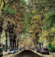
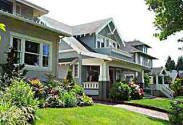
![]() Two comfortable Portland neighborhoods, near each other in southeast Portland, are Westmoreland (part of the Sellwood-Moreland neighborhood) and Eastmoreland. If you like wide tree-lined streets (lots of elms), quiet neighbors, and a variety of house styles, move to Eastmoreland. Take a drive on SE Reed − it's a boulevard with a median − and soon you'll be looking at the "Houses for Sale in Eastmoreland" ads in the paper.
Two comfortable Portland neighborhoods, near each other in southeast Portland, are Westmoreland (part of the Sellwood-Moreland neighborhood) and Eastmoreland. If you like wide tree-lined streets (lots of elms), quiet neighbors, and a variety of house styles, move to Eastmoreland. Take a drive on SE Reed − it's a boulevard with a median − and soon you'll be looking at the "Houses for Sale in Eastmoreland" ads in the paper.
To get to Eastmoreland from downtown head east and cross over the Willamette River. Take a right on SE Martin Luther King Jr. Boulevard (aka Highway 99). Proceed for four miles and you'll see the Eastmoreland Golf Course. The neighborhood extends north to SE Woodstock Street and then SE Bybee, south to SE Crystal Springs Boulevard, east to SE 39th Avenue, and west to approximately SE 25th Avenue.
The Eastmoreland Golf Course is a public 18-hole course on 140 acres. Chandler Egan, a former national amateur golf champion and leading golf course architect, designed the course, and in 1917, Portland had its first public golf course. Golf Digest ranks it among the nation's top 75 public course.
History of Eastmoreland
Both Westmoreland and Eastmoreland, like the Ladd and Laurelhurst subdivisions, were part of the real estate holdings of the Ladd Estate Company. Ladd had lots to suit most pocketbooks. Over in the southwest part of the greater Portland area were Ladd properties that became part of Dunthorpe, an aristocratic suburb of manor houses and country estates. To the north of Westmoreland and Eastmoreland is another Ladd property, Brooklyn. The center of Brooklyn is the Southern Pacific's railroad yards. When it was first developed and for some years thereafter, Brooklyn was home for hundreds of European immigrants, many of whom worked in the railroad yards.
The only sour note in Eastmoreland peaceful setting was the battle between the Southern Pacific Railroad (SP) and the Eastmoreland community. SP owned vacant land alongside its tracks between Eastmoreland and Westmoreland. The SP hoped to use those 15 acres to extend its Brooklyn yards. When that plan was proposed, in the early 1950s, Eastmoreland took the matter to court, claiming that such railroad expansion would cause damage to Eastmoreland property values, In 1956, a federal judge upheld the plaintiffs and enjoined the SP from expanding its yards.
Eastmoreland is the home of Reed College. Reed was founded in 1908, and its first classes were held in 1911. Reed is named for Oregon pioneers Simeon and Amanda Reed. Reed has a full schedule of lectures, concerts, and exhibits that many of the Eastmoreland residents attend.
Origin of the Name Eastmoreland
Eastmoreland got its name from Julius Caesar Moreland, a successful real estate developer and also a prominent county judge. The neighborhood to the west of Eastmoreland is called Westmoreland (part of the Sellwood-Westmoreland neighborhood association.
Eastmoreland Home Styles
Eastmoreland homes show a wide range of architectural styles popular in the 1920's and 1930's, including Tudor, Colonial, English Cottage, and stucco. Today the neighborhood is well established and stable. Of the 1,500 lots in the neighborhood, only a few remain empty.
You could put a manufactured home on a winding street in Eastmoreland with its 200 year-old trees and it would probably look good.
1Eastmoreland Home Prices
- Number of Homes Sold in Eastmoreland—► 76 homes sold in 2012 and 3% were distressed sales. 68 homes sold in 2011 and 16% were distressed sales. 56 homes were sold in 2010 and 4% distressed sales.
- Median Price for Homes Sold in Eastmoreland—► $486,000 in 2012, $425,000 in 2011, $542,500 in 2010, $435,000 in 2009, $535,000 in 2008, and $592,000 in 2007.
- 1-Year Median Sales Price Change in Eastmoreland—► The change was 14% in 2012, -23% in 2011, and in 2010 the change was 18%.
- 5-Year Median Sales Price Change in Eastmoreland: 2008 to 2012 the change was -9%. 2007 to 2011 the change was -29%. 2006 to 2010 the change was 1%.
- Portland Metro Area Median Home Price—► $235,000 in 2012, $221,000 in 2011, $239,900 in 2010, $247,000 in 2009, $278,000 in 2008, and $290,000 in 2007.
- Portland Metro Area Average Home Price—► $275,000 in 2012, $263,300 in 2011, $282,100 in 2010, $289,900 in 2009, $330,300 in 2008, and $342,000 in 2007.
Please be aware that the above figures are subject to error and are intended as guidelines only.
Eastmoreland Homes for Sale
Parks in Eastmoreland
 Eastmoreland has three parks. The Crystal Springs Rhododendron Gardens (9.49 acres) are botanical gardens located on SE 28 Avenue between the Eastmoreland Golf Course and Reed College. It is affectionately known as the "Rhody Gardens." The development of a display and test garden was initiated in 1950 by the Portland Chapter of the American Rhododendron Society. Referred to as Shakespeare Island by Reed College students because of the Shakespearean plays that had been performed there, it was abandoned and overgrown with brush and blackberries. Through the efforts of chapter members and other volunteers, and with the support of Park Superintendent C.P. Keyser, the garden flourished. The Crystal Springs Rhododendron Garden is is available for weddings, memorials, anniversaries, and other special events. Other parks:
- Eastmoreland Playground Park is a small park catering to children located at SE 30th Avenue and Crystal Springs Boulevard.
- Berkeley Park (6.45 acres) includes a baseball field, softball field, soccer field, park play area, walking paths, picnic tables, playground, tennis court, and an outdoor wading pool.
- At the south end of the neighborhood, lies part of the Springwater Corridor. This corridor is the major southeast segment of the 40-Mile Loop which was inspired by the 1903 Olmsted plan of a parkway and boulevard loop to connect park sites. The trail is over 21 miles long.
Eastmoreland has 90 acres of park land and open spaces according to Metro and the Portland Department of Parks and Recreation.
Reed College
Eastmoreland is the home of Reed College, a well-regarded liberal arts college founded in 1908. Reed College ranks in the top four of all U.S. colleges and universities for the percentage of graduates who earn Ph.D.s in all fields. It has produced 31 Rhodes scholars, second only to one other liberal arts college.
Reed is the only liberal arts college in the world with an operating nuclear reactor on its campus. Since the reactor only produces 250 kilowatts of heat (about 10 times as much as a home heating furnace), a meltdown or other serious event is not likely since the reactor doesn't produce enough heat to melt down.
Walking in Eastmoreland
Eastmoreland has a variety of walking tours to include a tour of historical homes, two tree walks, a garden walk, and a walk along the creek and bridges of the Springwater Corridor.
- Historical Homes Timber Press has published a walking tour of historical homes in the Eastmoreland and Sellwood neighborhoods. The tour guide provides a map, brief description of each home, and the address of each home. Click here to download the guide.
- Eastmoreland Tree Walks The Eastmoreland Neighborhood Association has two tree walks. You can download the guides at tree walks.
- Westmoreland to Crystal Springs Discover Crystal Springs Rhododendron Gardens in this four mile walk. Click here to download the guide.
- Southeast Portland Creeks and Bridges In 2006, three bridges opened on the Springwater Corridor Trail, closing a large gap in the 40-Mile Loop trail and reconnecting the communities. Click here to download the guide.
Walk Score helps you find a walkable place to live. Walk Score is a number between 0 and 100 that measures the walkability of any address. Portland is the 12th most walkable city in the U.S. with a Walk Score of 66 and 57% of the residents have a Walk Score of 70 or above.
The Eastmoreland neighborhood ranks 68 out of 89 Portland neighborhoods. Below is a Walk Score for an address in the center of the neighborhood.
More About Eastmoreland
- Neighborhood Association Web Site Eastmoreland Neighborhood Association.
- Location From downtown cross over the Willamette River on the Burnside Bridge and take a right on SE Martin Luther King Jr. Boulevard (aka Highway 99). Proceed for four miles and when you see the Eastmoreland Golf Course (on your left) you're in Eastmoreland.
- Topography Flat to very moderate rolling hills. Mature trees on most properties. Parks are wooded.
- Sidewalks and Streets The street pattern is a pleasing combination of grid and winding. The neighborhood has sidewalks for walking.
- Livability Study 97.7% of Eastmoreland residents rated their neighborhood "good" or "very good." The data for Eastmoreland was combined with their next door neighborhood, Ardenwald. See Livability Study.
- 2Drive Time to Downtown 16-18 minutes.
- Public Transportation There are seven bus routes in the neighborhood and Reed College students are frequent riders — see bus schedule and routes at the TriMet Web site. Transit Score provides a 0-100 rating indicating how well an address is served by public transportation. Ratings range from "Rider's Paradises" to areas with limited or no nearby public transportation.
- 32010 Census Demographics Population: 5,007. Area: 721 acres. Population density (people per acre): 6. Households: 1,593. Average size of household: 3.14 persons. Median household income: $79,259. Families with children: 26.2%. Homeowners: 92%. Renters: 8%. Diversity: 9.5% non-Caucasian. More census data about Eastmoreland at Portland Online.
- 4Crime Stats One violent crime and two crimes per 1,000 residents in 2012. Four violent crime in 2011 and total crimes per 1,000 people was 2. For the latest crime statistics for the Eastmoreland neighborhood, click here.
- Sex Offenders Click here for the State of Oregon Sex Offender Inquiry System. After agreeing to the "Conditions of Use Statement" you will be redirected to a "Enter Search Criteria" page. Insert a zip code in the "Zip" field and click on the "Query" button. Eastmoreland zip code: 97202.
- 5Shopping and Services Along the east border of Eastmoreland, SE 39th Avenue has a number of stores like Trader Joe's and neighboring Sellwood-Moreland has a New Seasons Market and a QFC. On the east edge of the neighborhood (SE Woodstock) Eastmoreland residents can travel a few blocks east on SE Woodstock and there are a number of business establishments including a Safeway Market. Also a hardware store along with numerous other retail establishments and restaurants are located in Moreland.
- Eating Out No eating places (other than Reed College and the Eastmoreland Club Course) are located in Eastmoreland. But you are close to Sellwood-Moreland, and they have a variety of eating establishments.
- Public Library The closest branch library of the Multnomah County Library system is the Sellwood-Moreland on SE 13th Avenue.
- Who Lives in Eastmoreland Doctors, lawyers, merchants, and professors from Reed College. Residents make certain their children receive a good education - the average daily attendance at Duniway Elementary is over 95%. Dr. Warren Bland, the author of Retire in Style: 60 Outstanding Places Across the USA and Canada retired to Eastmoreland in the Spring of 2006. The median age of a resident is 36.4 according to Census 2010.
- Cars in the Neighborhood If they make it, you'll see it on the streets of Eastmoreland. You would think that a college neighborhood would have all sorts of vehicles driving the neighborhood streets. But Reed is different from most colleges with regards to cars. Most Reed students are too busy to drive. Looks at the numbers and they reveal why Reed students are not found driving around Portland. Reed ranks first in the nation in the production of future Ph.D.s in the life sciences; second in chemistry and the humanities; third in foreign languages, history, and political science; fourth in the physical sciences, mathematics and computer sciences, and science and engineering; fifth in physics, social sciences, and sixth in anthropology. Among all institutions of higher learning, it ranks third in the nation in all fields.
- 6Biking Quality is fair. Eastmoreland has eight miles of bike lanes. Bicycle Trip Planner will map a route for you and − just provide a starting point address and your destination address.
- Schools Elementary school: Duniway. Middle school: Sellwood Middle School. High school: Cleveland High School.
- 7School Report Card Grades Elementary schools: O/S. Middle schools: O/S. High school: S. Click here for report card details.
Map of the Eastmoreland Neighborhood
Fly to the Eastmoreland Neighborhood via Google Earth

Coordinates
45° 47′ 53.67″ N,
122° 38′ 41.64″ W
Launch Google Earth
_______________________________________
1Real Estate Values Data on real estate values provided by RMLStm. Distressed properties refer to the percentage of total homes sold that were short sales and bank-owned properties.
2Drive Time to Downtown Estimated commuting time obtained from Yahoo Maps and Google Maps. Drive time was calculated from a central intersection in each neighborhood to Pioneer Courthouse Square during the morning peak commute time.
3Demographics Data Numbers were obtained from Census 2010 and www.portlandmaps.com.
4Crime Statistics Numbers on crime were obtained from Portland Police Bureau. Violent crimes are defined as murder, rape, robbery, and aggravated assault. Crimes per 1,000 are based on reported incidents of violent crime, as well as arson, burglary, larceny, and motor vehicle theft.
5Shopping and Services Numbers were determined from local directory listings and county/municipal library systems.
6Biking Quality rating based on the 2007 Cycle Zone Analysis conducted by the City of Portland Office of Transportation. The six-tier ratings have been reduced to three levels: High, Fair, and Low.
7School Report Card Grades Schools ratings from the Oregon Department of Education 2009-2010 performance assessment. "O" = Outstanding; "S" = Satisfactory; "I" = In Need of Improvement; NR = Not Rated.
|
View
|
Eastmoreland Boundaries
North to SE Woodstock Street and then SE Bybee, south to SE Crystal Springs Boulevard, east to SE 39th Avenue, and west to approximately SE 25th Avenue.
Map Showing
|
To learn more about the
|
Learn More
|

Guide to the Hosford-Abernethy Neighborhood in Portland, Oregon
 Located in southeast Portland, the Hosford-Abernethy neighborhood borders the Willamette River on the west, Southeast 29th Avenue on the east, Powell Boulevard on the south and Hawthorne Boulevard on the north. The neighborhood is a diverse combination of business, industry, and residential areas.
In the 1960s, plans were developed for a proposed Mt. Hood Freeway, which would have meant the destruction of numerous homes along Hosford-Abernethy’s southern edge closest to Powell Boulevard. This plan was shelved in 1974.
Entrance to the neighborhood from the west can be via the Hawthorne bridge on the north boundary and the Ross Island bridge on the south boundary. Coming into the neighborhood from the west, the first few blocks are all industrial that slowly turns into a mix of residential, including apartments, and industrial as you drive further east. Finally, at SE 13th Avenue, you’re in a residential area with detached single-family homes.
A few years ago you would have been an “urban pioneer” if you decided to buy a home in Hosford-Abernethy, but this neighborhood has changed so much (for the better) that you can still catch the trend and find an affordable home. It may require some TLC, but you will have company as many of your neighbors will be doing the same thing.
The Hosford-Abernethy neighborhood is comprised of several small neighborhoods, not receiving its official name (HAND) until the 1970s, as Portlanders began to create neighborhood associations. There is a tremendous wealth of history to the HAND neighborhood, a history that can be traced back to the area’s earliest settlements even prior to when it was part of the separate, incorporated city of East Portland. Hosford-Abernethy has undergone numerous changes since the mid-nineteenth century and continues its evolution to this day.
Val Ballestrem, a resident of the community and former neighborhood association board member, has written the history of the neighborhood which can be viewed online at the Hosford-Abernethy neighborhood Web site.
The heart of the neighborhood is located at SE 26th and SE Clinton which is a couple blocks south of SE Division. This is where a retail area has gradually grown so that it now contains 15 or so establishments to include restaurants, a New Seasons food market, coffee shops, a record shop, movie theater, a video store, and a gallery along with others. The businesses are spread over a 5-6 block area. All it needs is a bookstore to make it an authentic Portland neighborhood.
Another area in the neighborhood that is changing is around SE 11th Avenue and Division Street. The Ford building was purchased by Mike Tevis in 2005 and turned it into a home for artists, retail, offices, a cafe, marketing companies and other businesses. When it opened in 1914, it was a factory where Model T Fords were made. A building across the street, at 1100 S.E. Division, was formerly a Goodyear tire plant. But starting in 2012, Tevis will begin a renovation that will provide space for food cart operators and other businesses. There will be 11 or 12 spaces of about 300 to 400 square feet each and six spaces at about 1,000 square feet. The other building, at 1126 S.E. Division St., also has a history in the car industry. Currently, it houses an automotive parts wholesaler. Tevis hopes to attract light-industrial tenants such as printers to the building, which is expected to be renovated by the end of next year and will include eight spaces.
Two major public works projects are also expected to help spur growth in the area. The Portland-to-Milwaukie light rail line will include a MAX stop at Southeast 12th Avenue and Clinton Street, which will make the area more accessible. And a streetscape project that is expected to begin in early 2012 includes paving, public art, new trees, crosswalks, curb extensions and other amenities.
Neighborhood Issues
One of the issues in the neighborhood is traffic. The Portland Department of Transportation awarded a grant to study traffic on Division Street, the primary route through the center of the neighborhood. The goal of the grant is to plan for a pedestrian-oriented street and encourage more local business establishments. As a result, the community has been successful in bringing in a number of businesses. This means that the residents can shop in the neighborhood. They want to attract community-minded business owners, and it appears to be working. The neighborhood fought a Starbucks but the coffee house managed to open up a store on SE Division. It stayed open for a few months and the coffee chain eventually closed the store for lack of sales.
Ladd's Addition
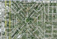 The neighborhood map reveals an uncommon street pattern just south of SE Hawthorne in an area known as Ladd’s Addition which is part of the Hosford-Abernethy neighborhood. The streets are in an orderly geometric form – a rectangle crossed by two diagonals, which divide the plat into four isosceles triangles. These are further divided into smaller triangles, quadrilaterals, parallelograms, and trapezoids. Also included were four diamond-shaped parks located on the points of a compass. It looks like a British Flag from the air layered against the grid pattern of the rest of the area. Each of these "circles" contain one of Portland's test rose gardens, with the northern garden's rose bushes being in a slightly different layout than the other three.
William S. Ladd platted this subdivision in 1891 and he named all but two of the streets after trees. He named one street after himself (Ladd Avenue) and another after his wife, Elliot Avenue. Two streets were later renamed because they were continuations of the grid of streets surrounding the subdivision, and some others were changed because of duplication in other parts of Portland.
The efforts to enhance the public spaces were one reason the American Planning Association honored Ladd's Addition, declared a city historic district in 1977 and listing it on the National Register of Historic Places in 1988. Criteria for being named a great neighborhood include architectural features, accessibility, functionality and community involvement. The American Planning Association, a not-for-profit educational organization, named Ladd's Addition one of the "Top 10 Great Neighborhoods" for 2009.
Origin of the Names Hosford and Abernethy
The neighborhood name came from two schools in the area: Hosford Middle School and Abernethy Elementary School. Chauncey O. Hosford was a one-time resident of Portland who owned 200 acres of land on Mt. Tabor. George Abernethy, like Hosford a Methodist missionary, was also Oregon's first provincial governor. Neither of these men lived or owned property in the neighborhood that bears their names, but both were important in the history of Oregon and Portland.
Home Styles
 Most of the houses in Ladd’s Addition as well as the rest of the area were built between 1905 and 1920. The neighborhood architectural styles can be described as “assorted” and the quality of maintenance varies from “needs work” to pleasantly preserved. Numerous apartment buildings are located on the west side of the neighborhood. You will see Bungalows, English Cottages, and Four-squares to name a few.
In the mid 90s, eastside builder Loren Waxman built four craftsman townhomes on SE 26th and others have been built since. A small condo development was built in the early 2000s at 21st and Clinton and more condos are starting to appear. Alternatives to detached homes means that a new type of resident is attracted to the neighborhood.
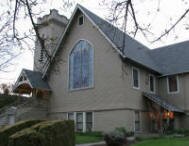
One of the more interesting buildings in the neighborhood is the Mizpah Presbyterian Church located at 2456 SE Tamarack Avenue. The building is on the National Register of Historic Places. The church is now a private residence. A photo of the building is above.
Ladd's Addition is a National Historic District and it was designated as one in 1988. The district boundaries: SE Division, SE Hawthorne, and SE 12th and SE 20th Streets. The district is 1,260 acres and 626 buildings. Home styles in the district include Bungalow/Craftsman along with late 19th and 20th Century Revivals
1Hosford-Abernethy Home Prices
- Number of Homes Sold in Hosford-Abernethy—► 81 homes sold in 2012 and 2% were distressed sales. 70 homes sold in 2011 and 19% were distressed sales. 65 homes sold in 2010 and 5% distressed sales.
- Median Price for Homes Sold in Hosford-Abernethy—► $370,000 in 2012, $351,000 in 2011, $370,000 in 2010, $363,900 in 2009, $389,900 in 2008, and $346,000 in 2007.
- 1-Year Median Sales Price Change in Hosford-Abernethy—► In 2012 the sales price change was 7%, sale price change was -4% in 2011, and the change was 1% in 2010.
- 5-Year Median Sales Price Change in Hosford-Abernethy—► 2008 to 2012 the sales price change was -5%. 2007 to 2011 the sales price change was 0%. 2006 to 2010 the sales price change was 3%.
- Portland Metro Area Median Home Price—► $235,000 in 2012, $221,000 in 2011, $239,900 in 2010, $247,000 in 2009, $278,000 in 2008, and $290,000 in 2007.
- Portland Metro Area Average Home Price—► $275,000 in 2012, $263,300 in 2011, $282,100 in 2010, $289,900 in 2009, $330,300 in 2008, and $342,000 in 2007.
Please be aware that the above figures are subject to error and are intended as guidelines only.
Hosford-Abernethy Homes for Sale
Parks and Gardens in Hosford-Abernethy
 The neighborhood has one small park at SE Division and SE 27th Street called Piccolo Park which has a playground for children. Powell Park borders the neighborhood on the south side at SE 26th Avenue and Powell Boulevard. The eight-acre park includes a baseball field, basketball court, soccer field, restroom, paths, picnic site, playground, and a wading pool.
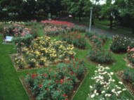
Known as the Ladd's Circles and Squares, the circle at SE 16th Avenue and Harrison Street has a formal landscape with camellias, perennials, and a lawn area in the central circle and numerous rose varieties in the four diamonds, creating a stained glass effect. Today the gardens feature over 3,000 roses of 60 varieties that were popular in the early 20th century. The roses are cared for by Portland Parks & Recreation staff and a devoted team of volunteers, the Friends of Ladd's Addition Gardens.
Hosford-Abernethy has two acres of park land and open spaces according to Metro and the Portland Department of Parks and Recreation.
Walking in Hosford-Abernethy
This 2.3-mile loop travels through historic inner Southeast neighborhoods with plenty of places to eat and drink along the way. The Ladd's Addition neighborhood has one of the most unusual street layouts in the nation: a diagonal pattern surrounding rose gardens. Getting lost on its elm-lined streets is a Portland tradition. Click here to download the guide.
Walk Score helps you find a walkable place to live. Walk Score is a number between 0 and 100 that measures the walkability of any address. Portland is the 12th most walkable city in the U.S. with a Walk Score of 66 and 57% of the residents have a Walk Score of 70 or above.
The Hosford-Abernethy neighborhood ranks 7 out of 89 Portland neighborhoods. Below is a Walk Score for an address in the center of the neighborhood.
More About Hosford-Abernethy
- Neighborhood Association Web Site Hosford-Abernethy. Visit the Clinton Street Weblog and Ladd's Addition Weblog to learn more about the Hosford-Abernethy neighborhood. The Hosford-Abernethy neighborhood is on Facebook.
- Neighborhood News The Bee covers southeast Portland. The Southeast Examiner is a free weekly publication.
- Location From downtown cross over the Willamette River on the Hawthorne Bridge. As you drive east on SE Hawthorne Boulevard the neighborhood will be on your right side.
- Topography Flat with mature trees on properties.
- Sidewalks and Streets The street pattern is grid - the west part of the neighborhood streets are full of cars due to the many apartments. The neighborhood has sidewalks for walking.
- Livability Study 94% of Hosford-Abernethy residents rated their neighborhood "good" or "very good." See Livability Study.
- 2Drive Time to Downtown About 15 minutes.
- Public Transportation This neighborhood has 13 bus routes but they do not have a MAX light rail line or a streetcar line. See schedules and routes at the TriMet Web site. Transit Score provides a 0-100 rating indicating how well an address is served by public transportation. Ratings range from "Rider's Paradises" to areas with limited or no nearby public transportation.
- 3Census 2010 Demographics Population: 7,336. Area: 824 acres. Average population density: 8 persons per acre. Number of households: 3,684. Average size of household: 2.07 persons. Median household income: $49,288. Families with children: 21.9%. Percent of home owners: 53%. Percent of renters: 47%. Diversity: 11.7% non-Caucasian. More census data about Hosford-Abernethy at Portland Online.
- 4Crime Stats 24 violent crimes and total crimes per 1,000 people was seven in 2012. 28 violent crimes and total crimes per 1,000 people was 61 in 2011. 11 violent crimes in 2010 and total crimes per 1,000 people was 57. For the latest crime statistics for the Hosford-Abernethy neighborhood, click here.
- Sex Offenders Click here for the State of Oregon Sex Offender Inquiry System. After agreeing to the "Conditions of Use Statement" you will be redirected to a "Enter Search Criteria" page. Insert a zip code in the "Zip" field and click on the "Query" button. Hosford-Abernethy code: 97202, 97214.
- 5Shopping and Services Number of supermarkets: 2. Number of health clubs: 1. Number of coffee shops: 6. New Seasons Market has a store at 1954 SE Division Street and the Peoples Coop food market is located at 3029 SE 21st Avenue. The neighborhood business community is located in a 5-6 block area of SE 26th and SE Clinton. The area has gradually grown so that it now contains 15 plus stores to include restaurants, coffee shops, a record shop, movie theatre, a video store, and a gallery along with others. Drive along SE Division Street and you will notice a number of thriving businesses. Every community needs a hardware store and Hosford-Abernethy has one - Hankins True Value Hardware is located at 1720 SE Hawthorne Boulevard. Click here to access a shopping guide/map of the Division Street area.
- Farmers Market Hinson Baptist Church parking lot, 1137 SE 20th Ave. Late afternoon on Thursdays, May-September. See portlandfarmersmarket.org.
- Eating Out The Savoy at 2500 SE Division is authentic Portland where dining room and bar features art plucked from Goodwill - the vintage furniture and other salvage items are almost as interesting as the food (American). Nuestra Cocina (means "Our Kitchen') at 2135 SE Division is one of Portland's hottest new restaurants serving food cooked in the central Mexico style. Located in the heart of Ladd's Addition, on the southwest segment of the roundabout that forms the neighborhood's center is Portland's Palio Dessert & Espresso House where a coffee purchase comes with a side of warm banter. Visit Willamette Weeks' Restaurant Guide by Neighborhood for a list of eating places in Hosford-Abernethy.
- Public Library The neighborhood does not have a public library but two libraries are about the same distance from the center of the neighborhood. The Belmont Library at 1038 S.E. 39th Avenue or the Woodstock Library at 6008 S.E. 49th Avenue. The Woodstock Library building was opened in 2000 and it has received numerous awards for its elegant and functional design, including a national honor from the American Institute of Architects and the American Library Association. This southeast Portland library is the home of a wealth of original artwork, including 36 stainless-steel panels on the exterior of the building etched with words depicting the history of books.
- Who Lives in Hosford-Abernethy White collar married couples in Ladd's Addition because it takes two incomes to afford a home in that area. Many singles live in the apartments on the west side of the neighborhoods. In the rest of the neighborhood, you will find many younger married couples starting their family along with a few singles and baby boomers. The median age of a resident is 38.
- Cars in the Neighborhood Japanese cars and you'll see a few Volvos in Ladd's Addition. And lots of bikers − many from Hosford-Abernethy − stream into downtown via the Hawthorne Bridge in the early morning on their way to work.
- 6Biking Quality is high. There are 15 miles of bike lanes in the neighborhood. Bicycle Trip Planner will map a route for you and − just provide a starting point address and your destination address.
- Schools Elementary school: Abernethy. Middle school: Hosford Middle School. High school: Cleveland High School.
- 7School Report Card Grades Elementary schools: O/S. Middle school: S. High school: S. Click here for report card details.
Map of the Hosford-Abernethy Neighborhood
Fly to the Hosford-Abernethy Neighborhood via Google Earth
Coordinates
45° 31′ 42.56″ N
122° 42′ 12.09″ W
Launch Google Earth
___________________________________
1Real Estate Values Data on real estate values provided by RMLStm. Distressed properties refer to the percentage of total homes sold that were short sales and bank-owned properties.
2Drive Time to Downtown Estimated commuting time obtained from Yahoo Maps and Google Maps. Drive time was calculated from a central intersection in each neighborhood to Pioneer Courthouse Square during the morning peak commute time.
3Demographics Data Numbers were obtained from Census 2010 and www.portlandmaps.com.
4Crime Statistics Numbers on crime represent were obtained from Portland Police Bureau. Violent crimes are defined as murder, rape, robbery, and aggravated assault. Crimes per 1,000 are based on reported incidents of violent crime, as well as burglary, larceny, and motor vehicle theft.
5Shopping and Services Numbers were determined from local directory listings and county/municipal library systems.
6Biking Quality rating based on the 2007 Cycle Zone Analysis conducted by the City of Portland Office of Transportation. The six-tier ratings have been reduced to three levels: High, Fair, and Low.
7School Report Card Grades Schools ratings from the Oregon Department of Education 2009-2010 performance assessment. "O" = Outstanding; "S" = Satisfactory; "I" = In Need of Improvement; NR = Not Rated.
|
View
|
Hosford-Abernethy Boundaries
North - SE Hawthorne Blvd.
|
|
Learn More
|
Guide to the Mount Tabor Neighborhood in Portland, Oregon
 Mount Tabor, named for the 600-foot high extinct volcano that is its landmark, has a sweeping city and mountain views, proximity to downtown, a scenic 195-acre public park, and an easy mix of modest older homes and stately mansions. Mt. Tabor is the only volcano within a major city in the United States.
Hawthorne Boulevard, the street full of shops and restaurants, ends at the base of Mount Tabor Park and it's one of the most used parks in the city. As you enter the park you will immediately notice reservoirs. They hold a large portion of Portland's drinking water, piped straight from the Bull Run Reservoir in the Cascades. The park has trails, bike paths, and stands of old growth Douglas Firs and other trees. Catch a summer sun setting on downtown and the West Hills from the park.
Mount Tabor is a very stable neighborhood, and people stay in Mount Tabor once they relocate to the area. Homes come in a variety of styles and shapes so people can usually find what they are looking for in a home.
History of Mount Tabor
The neighborhood has a long history that goes back almost as far as Portland itself. The Reverend Clinton Kelly settled on the east side of the river in 1848, and though his claim was west and south of Mount Tabor, his family figured prominently in the later history of the area. After purchasing claim rights for $50 he settled and began to farm while continuing circuit riding and preaching.
Reverend Kelly’s circuit riding duties took him throughout the lower Willamette Valley. He came into contact with Dr. Perry Prettyman, a fellow Methodist who had come to Oregon with his family from the east. After nearly two years in Oregon City, Prettyman and wife, Elizabeth, and family moved to Mount Tabor and staked out their claim. Probably a naturopath rather than an M.D., he had studied medicine at the Botanic Medical School in Baltimore. We have Prettyman to thank for that nemesis of the green lawn—the dandelion—for it was he who introduced that plant to the Northwest, having brought it here from Missouri for medicinal purposes. Prettyman practiced medicine up until his death in 1872.
The settlers in the Mount Tabor area were farmers, primarily engaged in fruit growing, and the area grew most of the fruit shipped from Portland to California. The gold rush in California created a demand for fruit and afforded huge profits to those who supplied it.
Some dates:
- 1846: The year of the "Big Burn" which destroyed the forests on the eastside.
- 1862: James B. Stephens donates land on U Street (now called Hawthorne) between Ninth and 12th avenues to J.C. Hawthorne for the Oregon Hospital for the Insane. U street becomes Asylum Avenue.
- 1870s: Railroads are introduced, fueling further settlement and expansion on the east side.
- 1883: The hospital closes and the land becomes a park. It takes another five years before Asylum Avenue is renamed, and takes the Hawthorne name.
- 1887: Morrison Bridge is completed, launching an East Portland building boom. A year later, the streetcar runs from downtown along Hawthorne and eventually south on SE 50th to Lents.
Origin of the Name Mount Tabor
Portland's Mount Tabor was named after another Mount Tabor, which sits six miles east of Nazareth in Israel. Our Mount Tabor makes Portland one of only two cities in the continental U.S. to have an extinct volcano within its boundaries; the other city is Bend, Oregon. It was a contest between Mount Tabor and Mount Zion.
Mount Tabor Home Styles
Mount Tabor is a neighborhood of detached single-family homes. This is an older neighborhood so most homes were built in the 1900s. You will see Arts and Crafts, Bungalows, Colonials, English Cottages, Tudors and a hand-full of modern styles.
An informative brochure about some of the architectural home styles found in the Mount Tabor neighborhood can be downloaded by clicking here. Included are addresses of Mount Tabor homes built in each architectural style.
1Mount Tabor Home Prices
- Number of Homes sold in Mount Tabor—► 131 homes sold in 2012 and 8% were distressed sales. 124 homes sold in 2011 and 10% were distressed sales. 111 homes sold in 2010 and 6% distressed properties sales.
- Median Price for Homes Sold in Mount Tabor—► $367,500 in 2012, $349,950 in 2011, $355,000 in 2010, $359,000 in 2009, $374,850 in 2008, and $399,500 in 2007.
- 1-Year Median Sales Price Change in Mount Tabor—► 2012 the change was -11%. 2011 the change was -1%. 2010 the change was -1%.
- 5-Year Median Sales Price Change in Mount Tabor—► 2008 to 2012 the sale price change was -10%. 2007 to 2011 the sales price change was -12%. 2006 to 2010 the sales price change was -4%.
- Portland Metro Area Median Home Price—► $235,000 in 2012, $221,000 in 2011, $239,900 in 2010, $247,000 in 2009, $278,000 in 2008, and $290,000 in 2007.
- Portland Metro Area Average Home Price—► $275,000 in 2012, $263,300 in 2011, $282,100 in 2010, $289,900 in 2009, $330,300 in 2008, and $342,000 in 2007.
Please be aware that the above figures are subject to error and are intended as guidelines only.
Mount Tabor Homes for Sale
Parks in Mount Tabor
 The 195-acre Mt. Tabor Park is one of Portland premier parks. The park includes basketball court, play area, a restroom, picnic area, dog off-leash area, picnic tables, playground, and tennis courts. This park is made for walking as it has miles of trails.
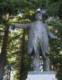
At the top of the park is a bronze statue of Harvey W. Scott, editor of The Oregonian newspaper from 1865-1872 and from 1877 until his death in 1910. A gift to the city by Scott's widow, Margaret, and family, it was sculpted by Gutzon Borglum in the early 1930s while at work on his monumental sculpture of four American presidents on Mt. Rushmore in the black hills of South Dakota.
In 2000, the city renovated park structures, roads and bathrooms. But the sprawling park had plenty of trails and places that offered spots where people could drink, use drugs or cause other problems. Parks officials began working with the Mount Tabor Neighborhood Association for ideas to make the park inviting and safe. From those meetings, the nonprofit Friends of Mount Tabor Park began. The group collects dues and sells T-shirts to raise money for park projects. Over the years, the group has paid for such things as bike racks, timber to replace rotted steps and a water supply in the picnic area. The patrol with 40 active members celebrated its 10th anniversary in 2010. The group has logged more than 2,700 patrols and donated more than 18,000 hours.
Take It Outside Fitness, a class taught by Kristin Jackson, a licensed personal trainer and lifestyle coach who lives in Southeast Portland has one of his classes meets at Mount Tabor Park twice a week, rain or shine, for an hour of cardiovascular exercise, strength training and stretching.
Mount Tabor has 184 acres of park land and open spaces according to Metro and the Portland Department of Parks and Recreation.
Mount Tabor Historic Reservoirs
 Mount Tabor has three reservoirs, all of which were accepted to the National Register of Historic Places in January 2004. The reservoirs are located in the Mount Tabor Park. Its elevation and central location relative to the city of Portland made this an ideal place for the city to house a water supply from the Bull Run reservoir in the Cascade Mountains.
The reservoirs were built during the period of 1894 and 1911, along with two reservoirs in Washington Park. The reservoirs and their gatehouses are artistically constructed, incorporating extensive stonework and wrought-iron. There were initially four above-ground reservoirs, numbered 1, 2, 5, and 6. Reservoirs 3 and 4 are at Washington Park, and Reservoir 7 is a small underground reservoir near Mount Tabor's summit. Reservoir 2, on the corner of SE 60th and Division, was decommissioned in the 1980s, and the property was sold to a private developer. Its gatehouse remains, and is used as a private residence. Reservoir 6 is the largest, with two 37 million gallon chambers; it also contains a fountain, which was unused for many years, however it was reactivated in early 2007.
These reservoirs are not filtered. This came to light on June 30th, 2008, when a local TV station reported two people were caught skinny dipping in one of the offline reservoirs the night of June 29th. Reservoir officials say its fortunate this particular reservoir was offline at the time, because draining and refilling it would have cost tens of thousands of dollars. However, it should be realized that birds, insects and wildlife contaminate the open-air unfiltered reservoir on a daily basis. After 9-11, the federal government mandated that all open water supplies be covered. This would would cost the city millions and citizens have organized and fought the covering of the reservoir both at Mount Tabor and Washington Park.
The Mount Tabor neighborhood Web site has detailed information about the reservoirs and their struggle to stay uncovered. Here is the link to the source.
Hawthorne Business District
Ask any Portlander where 'Hawthorne' is located and they will know. Hawthorne is not a "neighborhood" as such, but five neighborhoods converge on the area for shopping and dining. The Hawthorne Business District is about 20 blocks long starting at 30th Avenue and ending just a few blocks from the neighborhood's west boundary. Most of the establishments are small shops and locally owned except for the Fred Meyer superstore. It is one of the city's more interesting shopping areas.
Video of Mount Tabor Park and Playground
This video is about kids in the park and produced by Portland Family Advenures.
Walking in Mount Tabor
Explore the paths and historical features of Mount Tabor Park, home to reservoirs and a remnant volcanic cinder cone. The 2.1-mile walk combines stairs, closed roadways and unimproved paths as you climb and descent the summit. The payoff is the views. Click here to download the guide.
Another walk in Mount Tabor Park is the tree walk in which you identify over 30 trees. Click here to download the guide.
Walk Score helps you find a walkable place to live. Walk Score is a number between 0 and 100 that measures the walkability of any address. Portland is the 12th most walkable city in the U.S. with a Walk Score of 66 and 57% of the residents have a Walk Score of 70 or above.
The Mount Tabor neighborhood ranks 40 out of 89 Portland neighborhoods. Below is a Walk Score for an address in the center of the neighborhood.
More About Mount Tabor
- Neighborhood Association Web Site Mount Tabor Neighborhood Web site. The Mount Tabor neighborhood has a terrific Web site that is full of history and information about the community.
- Location From downtown cross over the Willamette River on the Burnside Bridge. Drive out on East Burnside and when you get to SE 50th Avenue, the neighborhood will be on your right side.
- Topography Flat to hilly on east end of neighborhood. Mature trees on properties. Parks are wooded.
- Sidewalks and Streets The street pattern is grid with sidewalks for walking.
- Livability Study 93.1% of Mount Tabor residents rated their neighborhood "good" or "very good." See Livability Study. The entire survey and response is available at the Mount Tabor neighborhood Web site.
- Public Transportation Bus routes 4, 15, and 20 run east/west and deliver passengers downtown. route 71 runs north/south. See schedule and routes at the TriMet Web site. Mount Tabor does not have a MAX light rail line or a streetcar line. Transit Score provides a 0-100 rating indicating how well an address is served by public transportation. Ratings range from "Rider's Paradises" to areas with limited or no nearby public transportation.
- 2Drive Time to Downtown 12-13 minutes.
- 3Census 2010 Demographics Population: 10,162. Area: 1,018 acres. Average population density: 9 persons per acre. Number of households: 4,689. Average size of household: 2.17 persons. Median household income: $57,244. Families with children: 20.5%. Percent of home owners: 63. Percent of renters: 37. Diversity: 12.5% non-Caucasian. More census data about Mount Tabor at Portland Online.
- 4Crime Stats Nine violent crimes in 2012 and total crimes per 1,000 people was 4. 14 violent crimes in 2011 and total crimes per 1,000 people was 33. 16 violent crimes in 2010 and total crimes per 1,000 people was 33. For the latest crime statistics for the Mount Tabor neighborhood, click here.
- Sex Offenders Click here for the State of Oregon Sex Offender Inquiry System. After agreeing to the "Conditions of Use Statement" you will be redirected to a "Enter Search Criteria" page. Insert a zip code in the "Zip" field and click on the "Query" button. Mount Tabor zip code: 97215.
- 5Shopping and Services Number of supermarkets: 0. Mount Tabor is all residential but surrounded on all sides by neighborhoods that have commercial centers. The main business activity is just west of the neighborhood around SE 39th Avenue and SE Hawthorne in the Sunnyside neighborhood. You will find a Fred Meyer supermarket, bookstore, deli, boutiques, a movie theatre, and a few restaurants. New Seasons Market, a local chain, revamped a building located at SE 41st and Hawthorne vacated by a natural food store and it opened in late 2009.
- Eating Out Just blocks (walking distance for the west end residents) to the west are two well-regarded restaurants: Three Doors Down at 1429 SE 37th Avenue and Bread and Ink at 3610 SE Hawthorne. Close by is Cup & Saucer and Chez Machin (the main attraction is the crêpes). Bridgeport Brewing at 3632 SE Hawthorne is the place for a cold one and a good burger. Also in the neighborhood are pizza shops, BBQ, and a fish sandwich eatery. See Willamette Week for reviews of restaurants in Mount Tabor.
- Public Library The neighborhood does not have a public library but two libraries are about the same distance from the center of the neighborhood. The Belmont Library at 1038 S.E. 39th Avenue and the Woodstock Library at 6008 S.E. 49th Avenue.
- Who Lives in Mount Tabor White collar singles and young married couples. Because of the range of home prices, you will get affluent couples. They tend their lawn and gardens, walk in the park, and stroll along Hawthorne Boulevard. The median age of a resident is 38.
- Cars in the Neighborhood Loads of smaller Japanese cars with a few pickups and SUVs. You'll see a luxury car at some of Mount Tabor's more elegant homes. One of the Webmaster's basketball playing buddies, who lives in Mount Tabor, drives a Volvo.
- 6Biking Quality ranges from high to fair. Mount Tabor has 11 miles of bike lanes. Bicycle Trip Planner will map a route for you and − just provide a starting point address and your destination address.
- Schools Elementary schools: Glencoe and Richmond. Middle school: Mount Tabor Middle School. High school: Franklin High School.
- 7School Report Card Grades Elementary schools: O/S. Middle school: S. High schools: S/I. Click here for report card details.
Map of the Mount Tabor Neighborhood
Fly to the Mount Tabor Neighborhood via Google Earth
Coordinates
45° 30′ 58.94″ N
122° 35′ 40.20″ W
Launch Google Earth
___________________________________
1Real Estate Values Data on real estate values provided by RMLStm. Distressed properties refer to the percentage of total homes sold that were short sales and bank-owned properties.
2Drive Time to Downtown Estimated commuting time obtained from Yahoo Maps and Google Maps. Drive time was calculated from a central intersection in each neighborhood to Pioneer Courthouse Square during the morning peak commute time.
3Demographics Data Numbers were obtained from Census 2010 and www.portlandmaps.com.
4Crime Statistics Numbers on crime were obtained from Portland Police Bureau. Violent crimes are defined as murder, rape, robbery, and aggravated assault. Crimes per 1,000 are based on reported incidents of violent crime, as well as burglary, larceny, and motor vehicle theft.
5Shopping and Services Numbers were determined from local directory listings and county/municipal library systems.
6Biking Quality rating based on the 2007 Cycle Zone Analysis conducted by the City of Portland Office of Transportation. The six-tier ratings have been reduced to three levels: High, Fair, and Low.
7School Report Card Grades Schools ratings from the Oregon Department of Education 2009-2010 performance assessment. "O" = Outstanding; "S" = Satisfactory; "I" = In Need of Improvement; NR = Not Rated.
|
View
|
Mount Tabor
|
To learn more about the
|
Learn More
|
Guide to the Sellwood-Moreland Neighborhood in Portland, Oregon
 Here's our list of ingredients for a thriving community: Parks, shopping, restaurants, access to public transportation, library, coffee shops, food markets, movie theater, and sidewalks. It would be an added bonus if the community had quality schools and close enough so that the kids could walk or have short bus rides. Sellwood-Moreland meets all of these conditions so you may want to investigate the neighborhood as a possible place to live.
Sellwood-Moreland is located five miles south of downtown Portland on the east side of the Willamette River. The Office of Neighborhood Involvement, the agency that oversees neighborhood associations, combines the neighborhoods of Sellwood and Westmoreland into Sellwood-Moreland. Westmoreland is on the east side of the community bordering McLoughlin Boulevard and Sellwood is on the west side bordering the river.
Couples with children have discovered the neighborhood. In the 2000 census there were 636 children under 18 living with their parents and this number jumped to 890 in the 2010 census. An increase of over 250 kids. As a result the neighborhood elementary school (Llewellyn) is extremely crowded. A few years ago the district was ready to close the school and consolidate it into another elementary. The Portland Public Schools (PPS) in November 2012 approved a boundary change. A portion of the Llewellyn boundary will be shifted to Duniway Elementary in Eastmoreland (the neighborhood directly east of Sellwoood-Moreland). The change plan provides that incoming students residing in the Sellwood residential area from S.E. Ochoco Street north to Tacoma Street, and from S.E. 17th Avenue east to McLoughlin Boulevard, be shifted from Llewellyn to Duniway. This change will begin in September of 2013 for new PPS students, including incoming kindergartners, new move-ins, or transfers from private schools, in grades one through five. Younger siblings of Llewellyn students have “a guaranteed space” at Llewellyn Elementary School, as do students currently attending that school.
 The community has two shopping areas. Coming off the Sellwood Bridge heading east, you encounter the first one at the intersection of Tacoma Street and 13th Avenue. It's the home of the Sellwood New Seasons Market along with a number of antiques stores, restaurants and other shops. The other commercial area is the Bybee/Milwaukee neighborhood less than a mile from the Tacoma/13th area and it has a market called QFC (division of Kroger's). Bybee/Milwaukee has a movie theater, coffee shops, restaurants, a florist, clinic, and a hardware store (they actually wait on you). Plus it also has a few antiques stores. The Moreland Theater is one of the last single screen movie theaters in Portland. A mix of first runs, art films, and lesser known treats. The Moreland seats 450 patrons and when the curtain rolls back, the movie begins. You don't have to sit through the 15 minutes of "coming attractions". And the popcorn is reasonably priced.
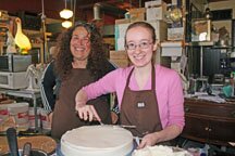
A favorite place in Sellwood-Moreland is a bakery called Piece of Cake at 8306 SE 17th Avenue. The bakery is without walls so you can see the entire operation to include ovens, stoves, etc. Here's Marilyn (the owner on the left) and her assistant decorating a cake. Visit their Web site at Piece of Cake Bakery to view their goodies to include many gluten-free baked goods.
 If you're interested in a PlayStation 3 or Xbox 360, don't bother stepping into Cloud Cap Games. But if you want old-fashioned board games made everywhere from across the street to across the globe fill the shelves at this Sellwood shop. James and Kirsten Brady, the owners of Cloud Cap Games, favor the low-tech joys of what one customer calls "analog" games because they require none of the batteries or electrical outlets that power today's digital gaming explosion. Board games are their specialty, but they also carry a good selection of card sets, puzzles and other game-related goods. It's family-friendly atmosphere and they have a whole shelf dedicated to children's games. And while many are internationally popular, the Bradys also also stock locally made wares, including games, dice bags and cribbage boards. Soon after opening, the Bradys started hosting Wednesday game nights at the store. Word spread quickly, and every week players have filled two tables in a side game room and a third table just inside the main store and this has grown to other times for groups gathering to play games. Cloud Cap Games is located at 1226 SE Lexington Avenue.
 What a bookstore should look like! Wallace Books is a house that's been jammed full of new and used books, and there is no nook or cranny that isn't swamped with piles and shelves. Julie Wallace, a former Powell's Bookstore employee, opened her own bookstore a few years ago in a 1,150-square-foot yellow house on 7241SE Milwaukie Avenue. Her business is based on the belief that people want the personal touch from their bookseller. She has time to talk to people about books, and she stays in business by catering to people who want personalized service. When Wallace studied the 1990 census, she learned that Sellwood/Westmoreland was becoming younger and more diverse; the average income, education levels and age groups were good for such a business. As a result of her research, the children's selection of books is outstanding.
During the summer, a Farmers Market with farm fresh local produce, nursery stock, cut flowers, local cheese, baked goods, bread, fish, meat, prepared food, specialty items is held every Wednesday mid-May through September, 3:30-7:30 p.m. at SE Bybee and 14th Avenue. For a complete list of all the business establishments in the community, visit the Sellwood-Moreland Business Association Web site.
Carl Abbott has a write up about former governor Barbara Roberts living in Sellwood-Moreland in his book Greater Portland.
Barbara Roberts loves her neighborhood. When she returned to Portland from Boston in 1998, she picked a modest Dutch Colonial in southeast Portland's Westmoreland neighborhood. A long established commercial street is only three blocks away. Roberts can walk to the grocery, the hardware store, a movie theater, and a choice of banks and restaurants. Roberts returned home because she wanted "to feel connected." In Portland's Sellwood-Westmoreland district she found a small town ambience that reminded her of Sheridan, the Oregon town where she grew up.
Westmoreland, she says, "feels like a neighborhood should feel," with a mix of elderly, young couples, and children. Residents are politically active, with high voter registration and turnout. They notice what others do with their yards and gardens; when she took down an aging tree that threatened her house and her neighbor, everyone had a comment. People in the neighborhood restaurant/bar treat her as family, shooing away belligerent customers who want to upbraid her for her mistakes in Salem (she backed a deeply unpopular sales tax to fund state services).
History of Sellwood-Moreland
The Sellwood-Moreland neighborhood began as the 1847 land claim of Henderson Llewelling who used the land to raise experimental strains of fruit. After Llewelling died in 1866, the 320 acre property was purchased by Rev. John Sellwood. In 1882, Sellwood sold 160 acres to several investors who laid out the town of Sellwood. Sellwood was incorporated in 1887 and then merged with Portland five years later. The area grew when streetcars began serving the area in 1892.
In early 1909 the 500-acre Crystal Spring livestock farm was platted into the subdivisions of Eastmoreland and Westmoreland. The developers promoted their developments as modern subdivisions which would be sold with sidewalks and curbs in place. Westmoreland's target market were the new white collar professionals who rode the streetcar to jobs in downtown Portland. The Eastmoreland Golf Course was also marketed to residents of both Westmoreland and Eastmoreland. By implication, Sellwood was an old-fashioned farm town.
The first quarter of the 20th century the two communities were in competition. As homes rose in Westmoreland, the newly-established local newspaper, the Sellwood Bee, became alarmed. It warned that a new commercial area might appear that would undermine the businesses in Sellwood. The first business, a doctor's office, was constructed at the southwest corner of Bybee and Milwaukie in 1911. As the new business area grew, competition between Sellwood and Westmoreland began and did not end for fifty years.
Events and Issues
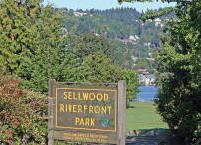 Sellwood Riverfront Park, overlooking the Willamette River, is the site on the first Sunday each August, for the Sundae on the Park − a civic event presented by the neighborhood association that features ice cream sundaes for a quarter, inexpensive hot dogs, old fashioned live entertainment, and displays and booths featuring historic topics related to the neighborhood. All of it, on the most unfailingly sunny weekend of the year, according to Oregon weather statistics.
Traffic impacts on Tacoma Street are a longstanding livability issue in the Sellwood-Moreland neighborhood. Every day more than 30,000 vehicles travel over the Sellwood Bridge through the heart of the neighborhood causing congestion all along Tacoma Street. Read about the proposed solutions at Tacoma Street Project.
Origin of the Names Sellwood and Moreland
The Sellwood part comes from Rev. John Sellwood, an Episcopal minister who held the land for a few years. Moreland is named after Julius Caesar Moreland, a successful real estate developer and also a prominent county judge. Many refer to Moreland as Westmoreland to differentiate it from their neighborhood directly east that is called Eastmoreland.
Sellwood-Moreland Home Styles
One of the first thing you notice driving around the community is the variety of homes within a given block. You will notice Bungalows, Cottages, Victorians mixed with a number of small nondescript one-story homes. Over the years, many of the homes in the neighborhood have been purchased by ambitious people who knew a bargain when they saw one. With some sweat, they have done extensively remodeling and adding square footage to their homes. And there are still homes available in the neighborhoods waiting for someone to give them a facelift.
Another trend is for in-fill builders to purchase older homes and replace them with new homes. North of Tacoma and both east and west of SE 13th Avenue you will note as least a dozen new homes. Homes close to the Sellwood Park on SE Bidwell, SE Lambert, SE Malden, and SE Rex seldom come on the market and when they do, they are sold fast.
The area along the west end of Sellwood near the Oaks Bottom Refuge have some elegant homes. Both the area south and north of the Sellwood Bridge have condo developments and many of the homes have views of the river life. There are 4-5 townhouse developments south of Tacoma.
1Sellwood-Moreland Home Prices
- Number of Homes Sold in Sellwood-Moreland—► 175 homes were sold in 2012 and 8% were distressed sales. 148 homes were sold in 2011 and 14% were distressed sales. In 2010 there were 138 homes sold and 9% distressed sales.
- Median Price for Homes Sold in Sellwood-Moreland—► $315,000 in 2012, $321,500 in 2011, $338,750 in 2010, $329,500 in 2009, $350,000 in 2008, and $354,800 in 2007.
- 1-year Median Sales Price Change in Sellwood-Moreland—► 2012 the sales price change was -2%. 2011 the sales price change was -4%. 2010 the sales price change was 4%.
- 5-year Median Sales Price Growth in Sellwood-Moreland—► 2008 to 2012 the sales price change was -10%. 2007 to 2011 the sales price change was -9%. 2006 to 2010 the sales price change was 0%.
- Portland Metro Area Median Home Price—► $235,000 in 2012, $221,000 in 2011, $239,900 in 2010, $247,000 in 2009, $278,000 in 2008, and $290,000 in 2007.
- Portland Metro Area Average Home Price—► $275,000 in 2012, $263,300 in 2011, $282,100 in 2010, $289,900 in 2009, $330,300 in 2008, and $342,000 in 2007.
Please be aware that the above figures are subject to error and are intended as guidelines only.
Sellwood-Moreland Homes for Sale
Parks in Sellwood-Moreland
The neighborhood is blessed with a river park, a wildlife refuge, along with a couple of parks that include just about every thing you need in a park. Plus they have an amusement park!
- Sellwood Riverfront Park is an 7.85 acre park on the Willamette River. It has a boat dock, dog off-leash area, paths, and picnic tables.
- The 16-acre Sellwood Park is located on the west side of the neighborhood and includes a baseball field, basketball court, picnic area, disabled access restroom, football field, horseshoe pit, walking paths, playground, soccer field, softball field, and tennis court. On the west edge of the park there is a magnificent stand of 75 plus Douglas Fir trees that provide shade for summer gatherings. The north end of the park has a variety of trees to include an Oregon White Oak, River Birch, (heritage tree), Sweet Gum, and Black Tupelo (heritage tree).
- Sellwood Pool is an outdoor, oval-shaped swimming pool, heated to 84 degrees, with a drop slide, kiddie slide, play structure, and spray features. Water depths range from zero depth entry to 8 feet. It is located at 7951 SE 7th Avenue.
- The 42-acre Westmoreland Park experienced periodic flooding resulting from a multitude of conditions contributing to high water in the crystal springs creek system. The rising waters inundated picnic areas, playgrounds, paths, and bench locations within the park. After years of study, construction is suppose to start with specific improvements in 2013. The Army Corps of Engineers is set to execute the first step which is the removal of the north-end duck pond and restoration of that section of the park to its original natural stream setting. This will benefit the fish using Crystal Springs Creek, and will make the north end more usable, by reducing the bird waste. Also planned is moving the play area to a higher ground. You can view the master plan for the park by clicking here but most likely much of the plan will not be implemented due to budget restrictions.
- The 141-acre Oaks Bottom Wildlife Refuge is a birdwatcher's paradise. Hawks, quail, pintails, mallards, coots, woodpeckers, kestrels, and widgeons are just the start of the list of birds that one might encounter in Oaks Bottom. The star of the show, though, is the Great blue heron, the official bird of the City of Portland.
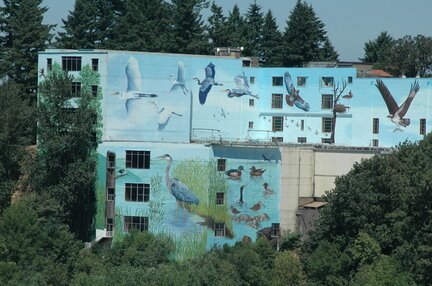
The photo to the left is one of the largest hand-painted murals in the country and it can be seen on Wilhelm's Portland Memorial Mausoleum. The artwork is visible from the Sellwood Bridge, the I-5 freeway, and sections of the Springwater Corridor Trail. Up close, it offers a Lilliputian view of dozens of native birds against a muted background of greens and blues. Some are in flight, a few forage for food along the shoreline and a lone eagle surveys the scene from a large remote branch. The mural covers about 50,000 square feet.
Westmoreland Park Casting Pond was "hand-dug" by residents during the depression as part of federal job-making efforts, the concrete pond is consider to be one of only 2-3 man-made casting ponds in the U.S.A. It is three feet deep, about 350 feet wide and 410 feet long. The pond opened in 1936 with an international fly-casting tournament. In 1940, the federal Works Progress Administration poured a concrete bottom.
The pond is a magnet for everything from fly casting to floating model boats. When it freezes over, you will even see some hockey on the ice. In years past, the Rose Festival has used it for milk carton races.
Sellwood-Moreland has 245 acres of park land and open spaces according to Metro and the Portland Department of Parks and Recreation.
Oaks Parks Amusement Center
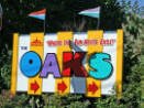 Sellwood is home to Oaks Park, one of only a handful of continuously-operating amusement parks in the United States. A modest operation, the park currently includes about two dozen rides that operate seasonally, a skating rink that is open year-'round, and picnic grounds. The Oaks has been a part of the lives of many Portlanders and other Oregonians for nearly a hundred years. It was built as an attraction to the 1905 Lewis and Clark Exposition. Managers of The Oaks sought to portray the resort as “The People’s Park” − a place that reflected the best that the city had to offer while still embracing its citizens’ fun-loving nature.
Sara Paulson, for her master's in history from Portland State University, wrote the history of the park which you can view at Oaks Park History. If you are a carousel fan, Portland photographer Jim Lommasson has documented the Oaks Park carousel by taking photographs over the years.
Share-It Square
 The intersection at SE Sherrett Street and SE 9th Avenue is painted in bright colors and serves as a central plaza with a community bulletin board, kids' playhouse, goods exchange, and a a 24-hour tea station. The square was improved by neighborhood residents with assistance from a local nonprofit called the City Repair Project.
After installation of Share-It Square, a survey revealed that more than 85 percent of residents felt that crime had decreased, traffic had slowed, and communication between neighbors had improved.
Sellwood Bridge
 The Sellwood bridge links the Sellwood-Westmoreland neighborhoods of Portland on the east side with Oregon Route 43/Macadam Avenue on the west side. It was built in 1925. Upon discovery of cracks in both concrete approaches in January 2004, the weight limit on the bridge was lowered from 32 tons to 10 tons. This has caused the diversion of over 75 daily bus trips over the bridge.
Planners and citizen groups have had numerous sessions as to whether the bridge should be repaired, rebuilt, closed altogether, or closed for automotive traffic but left open for pedestrians and bicycles. In early 2011 the Multnomah County commissioners unanimously approved a new deck arch design and cost-saving features for the Sellwood Bridge replacement. The proposed design of the new bridge is basically a bicycle and pedestrian bridge that only replaces the two existing motor vehicle lanes. Cost is estimated to be about $300 million.
The new Sellwood Bridge will include bicycle and pedestrian facilities on both sides. The final design includes a steel deck arch bridge, one-stage construction using a detour bridge, new access to Macadam Bay floating homes on the south side of Freeman Motors, and a west side regional trail along the trolley line from the bridge to SW Miles Place.

Construction started in late 2010 and the projected completion date is 2015. You can follow the progress of the new bridge at the Sellwoood Bridge Web site. For a live view of the construction site, check out the web camera on the Sellwood Bridge Web site. A time lapse feature allows you to view the day's work in a few seconds. You are able to watch videos that show work from the previous week and month.
Multnomah County is planning to use a detour bridge in order to save time and money during the construction of the new Sellwood Bridge. Referred to as a "Shoofly" in the construction trade, staged construction is not required. Instead, temporary piers are erected to the north of the existing bridge piers and the entire steel deck truss will be slid over on rails using hydraulic jacks. Temporary approach spans will then be installed at the east and west ends of the truss to link the structure to SE Tacoma Street and Highway 43. This temporary detour bridge will remain in place throughout construction of the new bridge, freeing up the existing alignment for the work crews and removing traffic from the bridge construction zone. The construction firm being hired to do this work – Slayden/Sundt Joint Venture – has successfully used this detour bridge method on other bridge projects. You can view an illustration of how the bridge will be moved during the week of January 17-24 by clicking here. The bridge is closed that week as the closure will allow the contractor to slide the 1100-foot truss a few feet to the north and attach it to the new river piers.
The Sellwood Bridge on Saturday, January 19, provided daylong entertainment for a crowd of hundreds of awestruck onlookers, as its 6.8 million-pound span moved — in what seemed miraculous to many — inches at a time onto new, temporary supports. The move came off flawlessly, capping months of planning and detailed preparations. Traveling about six feet per hour, the bridge's 1,100-foot-long steel truss slid so slowly along specially built tracks that actual movement was nearly impossible to discern. The move started at 7:30 A.M. under a heavy fog but by midmorning the sun was out and with temperatures in the 40s, it was a great day for moving a bridge and watching the historical event. Check out the video from the KATU-TV Web site.
Light Rail Coming to Sellwood-Moreland
Planners are working on the 7.3 mile Portland-Milwaukie Light Rail Project that is scheduled to be open for riders in 2015. It will travel past Portland State University, South Waterfront, over a new mixed-use transit bridge to OMSI and through inner Southeast on its way to Milwaukie. Sellwood-Moreland will have two stations on the line. One station will be located at SE Tacoma Street, and will include a park-and-ride garage. One station will be located at SE Bybee Blvd, under the Bybee Bridge. A third Sellwood-Moreland Station, at SE Harold Street, is designated for construction at some future point after the line has been completed.
Read more about the Portland-Milwaukie Light Rail Project.
Videos of the Sellwood-Moreland Neighborhood
- Walk in the Neighborhood with Tasteful Music A walk through the Sellwood neighborhood, Oaks Park, and Oaks Bottom Wildlife Preserve.
- Customers at the Blue Kangaroo Short interview with a barista at the Blue Kangaroo Coffee on SE 13th Avenue talking about her customers.
- Oaks Park Roller Skating Wurlitzer Band Organ at the Oaks Park Skating Rink.
- Riding the Trimet Bus along SE 12th and SE 17th Avenue A ride on Trimet Bus Route 70 along SE 17th and SE 12th Avenues. You get a view of the homes in the neighborhood.
- Pentanque Club Tour of the Portland Pentanque club located at Westmoreland Park. Pentanque is a form of boules where the goal is, while standing inside a starting circle with both feet on the ground, to throw hollow metal balls as close as possible to a small wooden ball called a cochonnet (literally "piglet") or jack. Interesting video about the game but the music is horrible.
Walking in Sellwood-Westmoreland
 This 3.8-mile walk combines the best of the city's urban landscape with its natural areas. Stroll the Sellwood neighborhood's scenic bluff top streets and travel the mixed-use Springwater Corridor Trail through Oaks Bottom, a 140-acre birdwatcher's paradise along the Willamette River. Bring your binoculars. Click here to download the guide.
The Springwater Corridor is a mixed-use trail system that begins in a Portland eastside industrial area and ends in Boring, Oregon. It cuts through Sellwood along the river in a north/south direction and then heads due east at the south end of the neighborhood The paved surface is 10-12 feet wide with soft shoulders. The hard surface trail is designed to accommodate walkers, joggers, hikers, bicycles, wheelchairs, and strollers. The Springwater Corridor began life in 1903 as the Springwater Division Line, a commuter railway that took folks from downtown Portland to outlying communities such as Estacada and Eagle Creek. In the 1950s, the automobile became the preferred method of travel and passenger service was dropped in 1958. In 1990, the city of Portland acquired portions of the corridor with the rest being picked up by Metro in the intervening years. The first stretches of the trail opened in 1996. In 2006, three bridges connecting the trail over McLoughlin Boulevard, were constructed which closed most of the gaps in the trail. Download a map of the Springwater Corridor.
Runners, walkers and cyclists needn’t scrutinize trail plans to name the region’s most notorious missing piece: the Sellwood Gap, which forces people off the Springwater Corridor for a mile in its namesake neighborhood in Southeast Portland. That gap will shrink dramatically, thanks to an agreement reached in October 2010 by Metro and the Oregon Pacific Railroad Co. More than half a mile of trail will be built alongside the train tracks the company operates, allowing commuters and outdoor enthusiasts to take the trail between Southeast Umatilla Street and Southeast 13th Avenue. If the Sellwood Gap is fully closed, visitors will be able to traverse 20 miles from central Portland through Milwaukie and Gresham to Boring without having to use public streets.
Here are some other walks in the neighborhood:
- Westmoreland to the Crystal Springs Rhododendron Gardens This 4.0-mile walk takes you from Westmoreland to the Crystal Springs Rhododendron Gardens − blazing colors from April through June with more than 2,500 rhododendrons, azaleas, and companion plants. The Crystal Springs emerge from Reed Canyon on the campus of Reed College. Click here to download the guide.
- Historical Homes Timber Press has published a walking tour of historical homes in the Eastmoreland and Sellwood neighborhoods. The tour guide provides a map, brief description of each home, and the address of each home. Click here to download the guide.
- Southeast Portland Creeks and Bridges In 2006, three bridges opened on the Springwater Corridor Trail, closing a large gap in the 40-Mile Loop trail and reconnecting the communities. Click here to download the guide.
- Sellwood Park and Neighborhood Tree Walk Identify over 40 trees on this walk. Click here to download the guide.
- Sellwood-Moreland Library Tree Walk Identify 31 trees on a 10-block walk east of SE 13th Avenue. Click here to download the guide.
Walk Score helps you find a walkable place to live. Walk Score is a number between 0 and 100 that measures the walkability of any address. Portland is the 12th most walkable city in the U.S. with a Walk Score of 66 and 57% of the residents have a Walk Score of 70 or above. The Sellwood-Moreland neighborhood ranks 27 out of 88 Portland neighborhoods. Below is a Walk Score for an address in the Sellwood neighborhood.
More About Sellwood-Moreland
- Neighborhood Association Web Site SMILE (Sellwood Moreland Improvement League). SMILE maintains an informational Website for the Oaks Pioneer Church at the east end of the Sellwood Bridge, for which it is the renting agent. Visit the Sellwood blog at OregonLive.com. The Sellwood-Moreland neighborhood is on Facebook. The Sellwood Moreland Business Alliance's maintains a list of over 50 businesses in the community and their Events Calendar is worth visiting. Thanks to Matt Millenback and SMILE, you can find information about emergency preparedness specific to the Sellwood-Moreland neighborhood at http://beprepared.sellwood.org.
- Neighborhood News The Bee covers southeast Portland. The Southeast Examiner is a free weekly publication.
- Location Follow the Willamette River south of downtown and cross over the Sellwood Bridge.
- Topography Flat with mature trees on properties. Parks are wooded.
- Sidewalks and Streets The street pattern is grid with sidewalks for walking.
- Livability Study 96.2% of Sellwood-Moreland residents rated their neighborhood "good" or "very good."
- 2Drive Time to Downtown 13-14 minutes.
- Public Transportation Bus route 65X is a direct downtown route — the neighborhood has five other routes. See schedule and routes at the TriMet Web site. Transit Score provides a 0-100 rating indicating how well an address is served by public transportation. Ratings range from "Rider's Paradises" to areas with limited or no nearby public transportation.
- 3Census 2010 Demographics Population: 11,621. Area: 1,155 acres. Population density: 10.1 persons per acre. Households: 5,562. Average size of household: 2.09 persons. Median household income: $47,913. Families with children: 22.1%. Home owners: 52%. Renters: 48%. Diversity: 9.1% non-Caucasian. More census data about Sellwood-Moreland at Portland Online.
- 4Crime Stats 11 violent crimes and total crimes per 1,000 was six in 2012. 18 violent crimes and total crimes per 1,000 was 51 in 2011. There were 21 violent crimes and total crimes per 1,000 people was 36 in 2010. For the latest crime statistics for the Sellwood-Moreland neighborhood, click here.
- Sex Offenders Click here for the State of Oregon Sex Offender Inquiry System. After agreeing to the "Conditions of Use Statement" you will be redirected to a "Enter Search Criteria" page. Insert a zip code in the "Zip" field and click on the "Query" button. Sellwood-Moreland zip code: 97202.
- 5Shopping and Services Number of supermarkets: 2. Number of health clubs: 2. Number of coffee shops: 6. Sellwood-Moreland has two quaint commercial areas separated by a quarter mile. Coming off the Sellwood Bridge heading east, you encounter the first one at the intersection of Tacoma Street and 13th Avenue and it's Sellwood New Seasons Market. This is one of New Seasons smallest stores so the selections are limited. This area also has an "antiques district" plus restaurants and other shops. The other commercial area is the Bybee/Milwaukee neighborhood and it has a quality market called QFC (division of Kroger's). Bybee/Milwaukee has the Moreland Theater, Starbucks, Dairy Queen, a florist, clinic, and a great hardware store (they actually wait on you). Pizzacato also has a restaurant and take-out store in Westmoreland. The neighborhood has a paint store, 3-4 bakeries, bike shops, cleaners, and a Les Schwab Tire Center. Click here to access a shopping guide/map of Sellwood and click here to access a shopping guide/map of Westmoreland.
- Farmers Market Southeast Bybee Boulevard at 14th Avenue. 3:30-7:30 pm Wednesdays, May-September. See Moreland Farmers Market.
- Eating Out Sellwood has some of the best neighborhood eateries in Portland with a large selection of different foods. Here are a few: Cena, El Palenque, Jade, Gino's, Saburo's Sushi, and others. Mike's Drive-in at SE Tacoma & SE 17th offers tasty burgers and malts. Visit Willamette Weeks' Restaurant Guide by Neighborhood for a list of eating places in Sellwood-Moreland.
- Public Library The Sellwood-Moreland library branch is located on SE 13th Avenue just off SE Bidwell Street.
- Who lives in Sellwood-Moreland Blue collar, white collar, and increasingly young married couples. The median age of a resident is 38.7 according to the 2010 census. What other neighborhood would have a restaurant named "Bertie Lou's" as well as one called "a Cena Ristorante." Journalist and historian Jeff Kisseloff and his wife Sue Sanders along with their daughter live in Moreland. Jeff is the author of five books, the latest being "Generation on Fire," an oral history of the 60s. Sue's essays have appeared in the anthologies "Ask Me About My Divorce," "Women Reinvented" and an assortment of local and national magazines and newspapers. Another writer, Joe Kurmaskie, lives in Sellwood. Joe has been a contributing writer to Bicycling Magazine, Details, and Men's Journal. He reviews books for The Oregonian and is a educator for Literary Arts Inc and Community of Writers - COW writer in residence at Portland State University. He is known for his book called the Metal Cowboy, the name came while cycling through Idaho, Kurmaskie met up with a blind man who, after tapping his cane over Joe and his bike, dubbed him a "metal cowboy."
- Cars in the Neighborhood If a GM vehicle or Ford is in the drive or in front of the home the owner is a long-time resident of the community. A Honda or Toyota is a sure sign of a newcomer. Just a handful of luxury autos in Sellwood and these are along Sellwood Boulevard.
- 6Biking Quality is fair. Sellwood-Moreland has 20 miles of bike lanes. Bicycle Trip Planner will map a route for you and − just provide a starting point address and your destination address.
- What's in the Recycle Bin Wine bottles and a good variety of beer to include everything from empty 'Bud' cans to bottles of micro brews.
- Schools Elementary school: Duniway and Llewellyn. Middle school: Sellwood Middle School. High school: Cleveland High School.
- 7School Report Card Grades Elementary schools: O/S. Middle school: S. High schools: O/S. Click here for report card details.
Map of the Sellwood-Moreland Neighborhood
Fly to the Sellwood-Moreland Neighborhood via Google Earth
Coordinates
42° 28′ 05.83″ N
122° 39′ 2.20″ W
Launch Google Earth
__________________________________________________
1Real Estate Values Data on real estate values provided by RMLStm. Distressed properties refer to the percentage of total homes sold that were short sales and bank-owned properties.
2Drive Time to Downtown Estimated commuting time obtained from Yahoo Maps and Google Maps. Drive time was calculated from a central intersection in each neighborhood to Pioneer Courthouse Square during the morning peak commute time.
3Demographics Data Numbers were obtained from Census 2010 and www.portlandmaps.com.
4Crime Statistics Numbers on crime were obtained from Portland Police Bureau. Violent crimes are defined as murder, rape, robbery, and aggravated assault. Crimes per 1,000 are based on reported incidents of violent crime, as well as burglary, larceny, and motor vehicle theft.
5Shopping and Services Numbers were determined from local directory listings and county/municipal library systems.
6Biking Quality rating based on the 2007 Cycle Zone Analysis conducted by the City of Portland Office of Transportation. The six-tier ratings have been reduced to three levels: High, Fair, and Low.
7School Report Card Grades Schools ratings from the Oregon Department of Education 2009-2010 performance assessment. "O" = Outstanding; "S" = Satisfactory; "I" = In Need of Improvement; NR = Not Rated.
View
|
Sellwood-Moreland Boundaries
North: Where McLoughlin Blvd. and the river meet at SE Holgate Blvd.
|
To learn more about the
|
Learn More About
|

Guide to the Sunnyside Neighborhood in Portland, Oregon
Also Known as Hawthorne
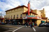 Sunnyside begins just 28 blocks east of the Willamette River. The lure of the neighborhood is accessibility, plenty of locally owned shops that keeps the neighborhood creative, and homes with character. Because of its Victorian architecture and bohemian culture, Hawthorne along with Belmont is often compared to San Francisco's Haight Ashbury district.
The landmark in the neighborhood is the Bagdad Theatre pictured on the left. Universal Studios spared little expense to build this ornate, balconied temple of entertainment in 1927. The Bagdad's interior is an attraction unto itself with barreled arches, ornate, wrought iron fixtures, brilliant-colored mosaic work, and painted and stenciled Mediterranean designs and mythical characters. The Bagdad has featured an incredible array of performances ranging from bawdy vaudeville stage shows to Technicolor extravaganzas. The Bagdad was the site of the premiere gala of One Flew Over the Cuckoo's Nest in 1975. Today, with nearly 700 seats, the theater offers a grand, well-designed forum for multimedia presentations.
Portlanders refer to the area as simply "Hawthorne" and they have in mind the area that runs along SE Hawthorne Boulevard between 30th and 42nd Avenues. It is known for its young, liberal residents and pedestrian-friendly high density mixed-use development. Historically, the district has been populated by Generation X and hippies, and more recently, hipsters. It is a young and vibrant neighborhood thanks to having two-thirds of the residents as renters. They are also attracted to Sunnyside's access to public transportation and affordable older homes.
Two business areas are located in the neighborhood, one along Hawthorne Boulevard and the other along Belmont Street. All along Hawthorne, you will find eateries, coffeehouses, pubs, unique shops, bookstores, and the famous Bagdad Theatre & Pub. It is also has a large Fred Meyer supermarket, one of the few chain stories in the area. Visit the Hawthorne Boulevard Business Association Web site for more information about the area.
Six blocks north of Hawthorne, Belmont Avenue is a historic corridor thick with boutiques and ethnic restaurants, centered around the neon lights of the Avalon Theatre located at 3451 SE Belmont Street. A dollar and a quarter gets you in. There are four screens; two will often carry first run flicks that cost a little more. Visit the Belmont Area Business Association Web site for more information about the area.
History of Sunnyside
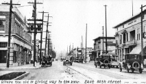 Hawthorne Boulevard’s was originally held by John McLoughlin of the Hudson Bay Trading Co., the land was subsequently sold to James B. Stephens, who in 1850 designated Hawthorne (then titled U Street) the southernmost boundary of the new city of East Portland. The same year, Stephens established the Stark Street ferry to transport agricultural commodities from fertile eastern areas to the fledgling town of Portland and beyond. Used by farmers as a commercial transit route, U Street was only a small dirt road, extending as far as present day 39th Avenue.
During the California and Southern Oregon gold rush of 1849, Stephens’ s agricultural shipping monopoly made him a handsome profit. Outer east side Hawthorne Boulevard was slower to develop than the area closer to the Willamette River. One major event, the 1846 forest fire popularly known as the “Big Burn,” had a critical impact on this area’s development. The fire, starting at the base of Mt. Scott and spreading almost to the Columbia River, cleared much of the thick forest at a time when settlers had just begun to stake claims.1 The result was an inviting flat, grassy area that was perfectly suited for pioneering farmers.
In 1858, another important figure, Dr. J. C. Hawthorne, arrived in Portland to care for many of the county’s indigent patients. Impressed by Dr. Hawthorne’s devotion and eager to see his town of East Portland grow, Stephens donated seven acres of prime property to the Oregon Hospital for the Insane in 1862. The hospital was constructed on a tract bounded by present-day Hawthorne Boulevard, SE Taylor Street, SE 9th and SE 12th avenues. At this time, U Street became known as Asylum Avenue. Run by Dr. Hawthorne and Dr. A. M. Loryea, the hospital became a major employer for the small city; 18-20 percent of the population of East Portland worked there by 1873.
To read more about the history of the neighborhood, download the document Historic Context: Hawthorne Boulevard from SE 20th to SE 55th Avenues.
Origin of the Name Sunnyside and Hawthorne
The book, Oregon Geographic Names, states that a post office existed in the neighborhood in the 1890s. It was located in the vicinity of SE Belmont Street between SE 29th and SE 37th Avenues and it was called Sunnyview. Portlander Karen Der Vee believes the neighborhood name "Sunnyside" comes from the Sunnyside farm, so named because it's not in the shadow of the West Hills. Karen notes that a plaque on a building at 33rd and Belmont, across from Zupan's Market, reveals this information.
Hawthorne Boulevard was named after Dr. J.C. Hawthorne, the cofounder of Oregon's first mental hospital which was located on Hawthorne Boulevard south of the Sunnyside neighborhood. The road was originally named Asylum Avenue. In 1883 the Oregon State Hospital moved to its present location in Salem. The street was renamed in honor of Dr. Hawthorne. Residents didn't much are for the old name and they petition to change the name to 'Hawthorne.'
Sunnyside Home Styles
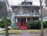 Many vintage homes are located in the Sunnyside area. The predominate styles are bungalows, four-squares, and Victorians. The area's housing styles are changing as townhomes and condos are beginning to appear. Developers can either buy a old home on a large lot and put up 2-3 townhomes or they buy two lots.
The 2000s have seen a number of smaller condo developments appearing in the neighborhood. Here's a list: SE Hawthorne Boulevard and 35th Avenue, SE 42nd Avenue, SE 38th Avenue, and SE 33rd Avenue.
The neighborhood has numerous multi-family homes in the neighborhood. they vary from small apartment building with 12-36 units in classic brick construction to plexes.
1Sunnyside Home Prices
- Number of Homes Sold in Sunnyside—► 82 homes were sold in 2012 and 11%. 63 homes were sold in 2011 and 16% were distressed sales. 88 homes were sold in 2010 and 10% distressed properties sales.
- Median Price for Homes Sold in Sunnyside—► $333,000 in 2012, $300,000 in 2011, $305,000 in 2010, $284,900 in 2009, $349,950 in 2008, and $358,750 in 2007.
- 1-Year Median Sales Price Change in Sunnyside—► 2012 the sales price change was 13%. 2011 the sales price change was -2%. 2010 the sales price change was 7%.
- 5-Year Median Sales Price Change in Sunnyside—► 2008 to 2012 the sales price change was -5%. 2007 to 2011 the sales price change was -18%. 2006 to 2010 the change was -17%.
- Portland Metro Area Median Home Price—► $235,000 in 2012, $221,000 in 2011, $239,900 in 2010, $247,000 in 2009, $278,000 in 2008, and $290,000 in 2007.
- Metro Area Average Home Price—► $275,000 in 2012, $263,300 in 2011, $282,100 in 2010, $289,900 in 2009, $330,300 in 2008, and $342,000 in 2007.
Please be aware that the above figures are subject to error and are intended as guidelines only.
Sunnyside Homes for Sale
Parks in Sunnyside
The neighborhood does not have a park but two parks are within a few blocks on two sides of it and a community pool/sports field 10-12 blocks to the west of it.
The 195 acre Mt. Tabor Park is on the east side of the neighborhood and on the north side is the 28 acre Laurelhurst Park. The Buckman Pool along with the 12 acre Buckman Field (athletic field) is on the west side of Sunnyside.
Christmas on Peacock Lane
 Since the 1920s, each house in this quaint southeast neighborhood has been decorating for Christmas. Mostly Tudors, the houses are adorned with not only beautiful sparkling lights, but also nativity scenes, rotating Christmas trees and stunningly life-like replicas of Santa and Frosty.
They even have their own song, The Peacock Lane Song, written by Elsie Bush. It goes, "IT'S A SPE-CIAL TIME OF YEAR! WIN-TER NIGHTS AND CHRIST-MAS CHEER! NORTH WINDS BLOW THE WEA-THER VANE – HAVE YOU SEEN THE LIGHTS ON PEACOCK LANE . . ."
This is a very popular Portland tradition and the crowds can get quite thick. It is wise to park several blocks away and walk, rather than drive through the area. Better yet, take a ride in a horse-drawn carriage.
Walking in Sunnyside
Sunnyside is a "browser" heaven. Stroll along Hawthorne Boulevard and SE Belmont Street and peek into the shops along the way.
Explore the paths and historical features of Mount Tabor Park, home to reservoirs and a remnant volcanic cinder cone. The 2.1-mile walk combines stairs, closed roadways and unimproved paths as you climb and descent the summit. The payoff is the views. Click here to download the guide.
Walk Score helps you find a walkable place to live. Walk Score is a number between 0 and 100 that measures the walkability of any address. Portland is the 12th most walkable city in the U.S. with a Walk Score of 66 and 57% of the residents have a Walk Score of 70 or above.
The Sunnyside neighborhood ranks six (6) out of 89 Portland neighborhoods. Below is a Walk Score for an address in the center of the neighborhood.
More About Sunnyside
- Neighborhood Association Web Site Sunnyside.
- Location Drive out of downtown on the Hawthorne Bridge and after a few blocks, you will be on SE Hawthorne Boulevard. When you come to SE 28th Avenue, Sunnyside will be off to your left.
- Topography Flat with mature trees on properties. Parks are wooded.
- Sidewalks and Streets The street pattern is grid with sidewalks for walking.
- Livability Study 93.8% of Sunnyside residents rated their neighborhood "good" or "very good."
- 2Drive Time to Downtown 10-11 minutes.
- Public Transportation Four bus routes run through the neighborhood. see schedule and routes at the TriMet Web site. Transit Score provides a 0-100 rating indicating how well an address is served by public transportation. Ratings range from "Rider's Paradises" to areas with limited or no nearby public transportation.
- 3Census 2010 Demographics Population: 7,354. Area: 382 acres. Population density: 19 persons per acre. Households: 3,894. Average size of household: 1.89 persons. Median household income: $54,713. Families with children: 20.5%. Home owners: 37%. Renters: 63%. Diversity: 10.8% non-Caucasian. More census data about Sunnyside at Portland Online.
- 4Crime Stats 12 violent crimes and crimes per 1,000 was five in 2012. 26 violent crimes in 2011 and total crimes per 1,000 people was 50. 20 violent crimes in 2010 and total crimes per 1,000 people was 47 . For the latest crime statistics for the Sunnyside neighborhood, click here.
- Sex Offenders Click here for the State of Oregon Sex Offender Inquiry System. After agreeing to the "Conditions of Use Statement" you will be redirected to a "Enter Search Criteria" page. Insert a zip code in the "Zip" field and click on the "Query" button. Sunnyside zip code(s): 97214, 97215.
- 5Shopping and Services Number of supermarkets: 2. Number of health club: 1. number of coffee shops: 6. Sunnyside has two commercial areas - one on the north side called Belmont and the other on the south side called Hawthorne. The main business activity takes place from the hub at SE 39th Avenue and SE Hawthorne. You will find a Fred Meyer supermarket, bookstore, deli, boutiques, a movie theatre, and a few restaurants. In other words, just about everything you would need can be purchased in the neighborhood. New Seasons Market has a store at 41st and Hawthorne that they opened in late 2009. Click here to access a shopping guide/map of Hawthorne and click here for a shopping guide/map of Belmont.
- Eating Out The Hawthorne area has some well-established eating spots along with coffee and pizza places. Three Doors Down at 1429 SE 37th Avenue and Bread and Ink at 3610 SE Hawthorne. Close by is Cup & Saucer and Chez Machin (the main attraction is the crêpes). Bridgeport Brewing at 3632 SE Hawthorne is the place for a cold one and a good burger. Also in the neighborhood are pizza shops, BBQ, and a fish sandwich eatery. Visit Willamette Weeks' Restaurant Guide by Neighborhood for a list of eating places in Sunnyside. The Belmont area has been adding new businesses in the last few years and now has 4-5 eating places.
- Public Library The neighborhood's Belmont Library is located at 1038 S.E. 39th Avenue - between SE Yamhill and SE Taylor.
- Who lives in Sunnyside Singles as 42 percent of the residents live in a one person household. Only 7.4% of the households have children. Close to two-thirds of the residents are under 39 years of age. The median age of a resident is 36.
- Cars in the Neighborhood Pickups, SUVs, Chevys, Fords, and a few Hondas/Toyotas/Nissans. Luxury autos are rare.
- 6Biking Quality is high. The neighborhood has five miles of bike lanes. Bicycle Trip Planner will map a route for you and −just provide a starting point address and your destination address.
- Schools Elementary school: Sunnyside K-8 and Glencoe. Middle school: Sunnyside K-8. High school: Cleveland High School and Franklin High School. Belmont Academy is a private, non-affiliated school offering preschool and elementary school education.
- 7School Report Card Grades Elementary schools: O. Middle school: S. High school: S. Click here for report card details.
Map of the Sunnyside Neighborhood
Fly to the Sunnyside Neighborhood via Google Earth
Coordinates
45° 30′ 58.29″ N
122° 37′ 25.90″ W
Launch Google Earth
_____________________________________________
1Real Estate Values Data on real estate values provided by RMLStm. Distressed properties refer to the percentage of total homes sold that were short sales and bank-owned properties.
2Drive Time to Downtown Estimated commuting time obtained from Yahoo Maps and Google Maps. Drive time was calculated from a central intersection in each neighborhood to Pioneer Courthouse Square during the morning peak commute time.
3Demographics Data Numbers were obtained from Census 2010 and www.portlandmaps.com.
4Crime Statistics Numbers on crime were obtained from Portland Police Bureau. Violent crimes are defined as murder, rape, robbery, and aggravated assault. Crimes per 1,000 are based on reported incidents of violent crime, as well as burglary, larceny, and motor vehicle theft.
5Shopping and Services Numbers were determined from local directory listings and county/municipal library systems.
6Biking Quality rating based on the 2007 Cycle Zone Analysis conducted by the City of Portland Office of Transportation. The six-tier ratings have been reduced to three levels: High, Fair, and Low.
7School Report Card Grades Schools ratings from the Oregon Department of Education 2009-2010 performance assessment. "O" = Outstanding; "S" = Satisfactory; "I" = In Need of Improvement; NR = Not Rated.
|
View
|
Sunnyside
|
To learn more about the
|
Learn More
|