| Subscribe to the Moving to Portland Newsletters |
51°F
52°F / 70°F
54°F / 58°F
51°F / 57°F
Guide to the Bridlemile Neighborhood in Portland, Oregon
 This is a neighborhood of "Can Do" people, so if "involvement" is your motivation, you will fit right in.
The best proof of the neighborhood involvement is to visit the Bridlemile Web site by clicking here. Note all the activities in the community.
The Bridlemile Community Outreach Committee is dedicated to bringing neighbors together through social events such as picnics and potlucks and by helping promote neighborhood communication, projects, and a sense of place and history.
The photo above is from a community picnic where the local fire station personnel were invited (to include partaking in the picnic dinner) to explain their jobs and responsibilities. The firefighters made certain that every kid received a fire hat.
A few years ago, some of the Bridlemile neighborhood residents got concerned about their environment and formed Bridlemile Creek Stewards. The Stewards have successfully initiated and carried out a number of restoration projects. They have cleared over four acres, including more than 2000 feet of stream bank, and saved over 200 trees from ivy infestations. They planted over 7,700 native plants, installed erosion control and held four annual Southwest Portland Neighborhood Stream Festivals in 1999-2002.
Because of the success of these projects, they received a Community Service award from SOLV and were nominated for the Tualatin Riverkeepers Green Heron Award in 2000, 2001, 2002 and 2003.
Origin of the Name Bridlemile
Jack and Ruth Powell were early land owners of the area. Ruth Powell explained that in 1947 her husband, Jack, was looking for property in Portland with enough acreage to build a home and garden. They planned to develop the property and needed a name for it. One night, before they moved to the area, Ruth Powell was brushing her teeth and thinking about the land. She thought, "Bridlemile, that is it."
Bridlemile Home Styles
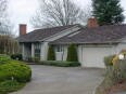
Many of the homes in Bridlemile were built in the 50s, 60s, and early 70s and the styles include ranch, split levels, and contemporary. A number of new homes were built in the 2000s. If you're looking for a single level home in the woods, you're sure to find one in Bridlemile.
1Bridlemile Home Prices
- Number of Homes Sold in Bridlemile—► 76 homes were sold in 2012 and 14% were distressed sales. 46 homes were sold in 2011 and 9% of them were distressed sales. 36 homes were sold in 2010 and 8% of them were distressed properties sales.
- Median Price for Homes Sold in Bridlemile—► $362,500 in 2012, $395,000 in 2011, $385,500 in 2010, $425,000 in 2009, $460,000 in 2008, and $500,000 in 2007.
- 1-Year Median Sales Price Change in Bridlemile—► 2011 to 2012 the change was -8%. 2010 to 2011 the change was 2%. 2009 to 2010 the change was -9%.
- 5-Year Median Sales Price Change in Bridlemile: 2008 to 2012 the change was -22%. 2007 to 2011 the change was -21%. 2006 to 2010 the change was -20%.
- Portland Metro Area Median Home Price—► $235,000 in 2012, $221,000 in 2011, $239,900 in 2010, $247,000 in 2009, $278,000 in 2008, and $290,000 in 2007.
- Portland Metro Area Average Home Price—► $275,000 in 2012, $263,300 in 2011, $282,100 in 2010, $289,900 in 2009, $330,300 in 2008, and $342,000 in 2007.
Please be aware that the above figures are subject to error and are intended as guidelines only.
Bridlemile Homes for Sale
Parks in Bridlemile
The neighborhood has two parks within its boundaries.
- Albert Kelly is a 12-acre park that has paths for hikers and runners along with a soccer field and playground. In 2003, thanks to the efforts of the Bridlemile Creek Stewards, volunteers cleared out the blackberries, ivy and holly from the creek area in the northeast area of the park, and replace them with more appropriate native trees and shrubbery. They planted of hundreds of seedlings to include ponderosa pine, Douglas fir, grand fir, western hemlock, white alder, Oregon white oak and pacific willow. In addition, several varieties of roses, Oregon grape, flowering currants, a Chilean strawberry and other shrubs were planted along the banks of the creek.
- Hamilton Park (10 acres) has paths, a soccer field, a softball field, and a tennis court.
Bridlemile has 34 acres of park land and open spaces according to Metro and the Portland Department of Parks and Recreation.
Bridlemile Elementary
 The Bridlemile neighborhood has one of the best elementary schools in the Portland District as judged by their annual report card. The Bridlemile Elementary School has consistently received an "Exceptional" rating on the Oregon Report card rating system.
The school grounds, because of the large size, function as a neighborhood gathering place. It has two baseball diamonds which serve as an extension of Hamilton Park, a 10-acre park with green space and a renovated play structure.
The photo above was taken by Victor von Salza and shows kids playing soccer at Hamilton Park. VIctor has more community photos at the Bridlemile Flickr Web site.
Walking in Bridlemile
The SW Trails Group is a committee of Southwest neighborhoods that uses volunteer efforts to make trail improvements, lead walks, work with Safe Routes to School, plan and advocate for pedestrian and bicycle safety and other improvements in Southwest Portland. Their walks are the second Saturday of each month. You can pick up a free a Southwest Portland Walking Map at the local SWNI Office or download it at PDF format.
Below are a few tours to get you started. The "Browse through Bridlemile" walk with its detailed notes about particular things to see along the route is a winner.
- Browse through Bridlemile
- Fall Color Walk
- Spring Color Walk
- SW Bridlemile Notable Homes Walking Tour
Walk Score helps you find a walkable place to live. Walk Score is a number between 0 and 100 that measures the walkability of any address. Portland is the 12th most walkable city in the U.S. with a Walk Score of 66 and 57% of the residents have a Walk Score of 70 or above. The Bridlemile neighborhood ranks 75 out of 88 Portland neighborhoods. Below is a Walk Score for an address in the center of the neighborhood.
More About Bridlemile
- Neighborhood Association Web Site Bridlemile has one of the most informative neighborhood Web sites in the Portland community. Neighborhood residents have close to a 100 photos at their Bridlemile Flickr site.
- Location Southwest of downtown. Close enough to downtown but still out of the traffic and noise.
- 2Drive Time to Downtown 12-13 minutes.
- Topography Gentle rolling hills all in a wooded setting.
- Sidewalks and Streets It's easy to get lost in Bridlemile as the winding streets often lead to dead-ends. Very few sidewalks.
- Livability Study 97% of the Bridlemile residents rated their neighborhood "good" or "very good." See Livability Study.
- Public Transportation Bridlemile does not have access to MAX light rail or the streetcar line. It does have five bus routes in the neighborhood. See TriMet for schedules. Transit Score provides a 0-100 rating indicating how well an address is served by public transportation. Ratings range from "Rider's Paradises" to areas with limited or no nearby public transportation.
- 32010 Census Demographics Population: 5,481. Area size: 901 acres. Average population density: 6 persons per acre. Number of households: 2,497. Average size of household: 2.2 persons. Median household income: $91,948. Percent of home owners: 67. Percent of renters: 33. Families with children: 23.5%. Diversity: 9.8% non-Caucasian. More census data about Bridlemile at Portland Online.
- 4Crime Stats 12 violent crimes and two crimes per 1,000 residents in 2012. Twp violent crime in 2011 and total crimes per 1,000 residents was two. For the latest crime statistics for the Bridlemile neighborhood, click here.
- Sex Offenders Click here for the State of Oregon Sex Offender Inquiry System. After agreeing to the "Conditions of Use Statement" you will be redirected to a "Enter Search Criteria" page. Insert a zip code in the "Zip" field and click on the "Query" button. Bridlemile zip code(s): 97221, 97239.
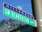
- 5Shopping and Services Number of supermarkets: 1. Number of health clubs: 1. Two large supermarkets exist on the south border of the neighborhood on the Beaverton-Hillsdale Highway: Safeway and Albertsons. The road is a busy one with numerous commercial establishments along it. You can get your car service, hair cut, and meet with your realtor if it is a Windermere agent working out of the Raleigh Hills office.
- Eating Out The Beaverton-Hillsdale Highway has a couple fast food places and also two note worthy restaurants. One is the Pepper Tree Thai. An Irish pub sits in the far southwest corner of the neighborhood.
- Public Library The neighborhood does not have a public library - the closest one is the Hillsdale Library.
- Who Lives in Bridlemile Active people who want to contribute to their community. The median age is 44.
- Autos in the Neighborhood I would venture to say that this community has more small cars (including hybrids) per capita than any other neighborhoods in Portland (maybe even in the entire country).
- 6Biking Quality is low. Bridlemile has five miles of bike lanes.
- Schools Elementary school: Bridlemile Elementary. Middle school: East-West Sylvan. High school: Lincoln High School and Wilson High School.
- 7School Report Card Grades Elementary school: O. Middle schools: O/S. High schools: O. Click here for report card details.
Map of the Bridlemile Neighborhood
Fly to the Bridlemile Neighborhood via Google Earth

Coordinates
45° 47′ 53.67″ N,
122° 38′ 41.64″ W
Launch Google Earth
___________________________________
1Real Estate Values Data on real estate values provided by RMLStm. Distressed properties refer to the percentage of total homes sold that were short sales and bank-owned properties.
2Drive Time to Downtown Estimated commuting time obtained from Yahoo Maps and Google Maps. Drive time was calculated from a central intersection in each neighborhood to Pioneer Courthouse Square during the morning peak commute time.
3Demographics Data Numbers were obtained from Census 2010 and www.portlandmaps.com.
4Crime Statistics Numbers on crime were obtained from Portland Police Bureau. Violent crimes are defined as murder, rape, robbery, and aggravated assault. Crimes per 1,000 are based on reported incidents of violent crime, as well as burglary, larceny, and motor vehicle theft.
5Shopping and Services Numbers were determined from local directory listings and county/municipal library systems.
6Biking Quality rating based on the 2007 Cycle Zone Analysis conducted by the City of Portland Office of Transportation. The six-tier ratings have been reduced to three levels: High, Fair, and Low.
7School Report Card Grades Schools ratings from the Oregon Department of Education 2009-2010 performance assessment. "O" = Outstanding; "S" = Satisfactory; "I" = In Need of Improvement; NR = Not Rated.
|
View
|
Bridlemile Boundaries
West: SW Scholls Ferry Road.
|
To learn more about the
|
Learn More
|
Feldman-Brown House
Philip and Marianne Feldman built this Northwest Regional home in 1956. In June 1957 the house earned an “Award of Merit” by the Oregon Chapter of the AIA for professional excellence by the architect. |


Guide to the Hillsdale Neighborhood in Portland, Oregon
 Travel down I-5 south for 3.5 miles from downtown and the area off to the west is Hillsdale. Driving through the neighborhood, you will note many shops, pubs, restaurants and coffee houses.
With the close proximity of schools, parks, a library, and a shopping center, many families find this neighborhood a mix of suburbia yet very close to downtown.
A typical Hillsdale resident is white, college educated and fairly well-off. He or she is either an empty-nester or a parent with young children − with not much in between. About one out of four residents are what marketers call Metropolitans − they listen to jazz, classical, public and alternative radio and attend rock concerts, watch foreign films, read magazines and play a musical instrument. That’s among the findings of a trade-area analysis completed for the Hillsdale Main Street program by Josh Lehner, a neighborhood resident and a state economist that was released in early June of 2011.
Located at the 6000's block of SW Capitol Highway are numerous small shops and eating places. You will find just about kind of store that you need in the shopping area. This include a bakery, bank, cleaners, clothing, ice cream, laundromat, liquor store, pharmacy, pet wash, post office, veterinary, and video store. Restaurants include a a number of ethic food establishment to include Chinese, Mexican, and Thai. The area also has a pizza and sandwich shop.
Food Front has been open in Hillsdale since Sept 2008 and provides fresh, local natural and organic food. Although anyone can shop at this co-op, ownership by community members is encouraged and owner/members receive benefits not available to non-member shoppers. The photo above shows a customer checking out at the store.
The Hillsdale Farmers' Market is the only year round farmers market in the Portland metro area. Attendance at the market is often over 3,000 people each Sunday. The winter schedule is every other week from December to April. The market is held in the parking lot between Rieke Elementary and Wilson High School where there is parking for several hundred cars.
Here are some Web sites to visit to learn more about Hillsdale:
- Hillsdale News Get the local news.
- Hillsdale Business & Professional Association More than 60 local businesses and professionals are members of the group.
- Hillsdale Main Street The Main Street® approach is a community-driven, comprehensive method used to revitalize older, traditional business districts.
History
 In the 1880's, Hillsdale was settled by German, Swiss and Italian immigrants. These new settlers cleared the forests and operated dairies and vegetable farms to supply food for the growing city of Portland.
In the 1890's, Southern Pacific Railroad built a line from Portland to Forest Grove, running along present day Barbur Boulevard, to what is now known as Bertha Boulevard. The Hillsdale stop was named the Bertha Station after the wife of one of the Southern Pacific officials.
In 1912, Terwilliger Boulevard opened. In 1950, Fred Meyer built a large supermarket on Barbur Boulevard at Bertha Boulevard. In 1954, a 54 acre parcel was developed called the Wilson Park housing development. In 1956, Wilson High School and Wilson Park Elementary School were built on the former Fulton Park Dairy site.
In 1993, the Hillsdale Vision Group was formed to discuss ways to improve Hillsdale. Hillsdale was nominated to become a Town Center under Metro's Region 2040 plan. In 1997, the Portland City Council approved the Hillsdale Town Center Plan. The project made Hillsdale consumer and pedestrian friendly.
In 2010, the Hillsdale Town Center was designated a Main Street District by the National Trust for Historic Preservation. The Main Street program aims to preserve and revitalize historic commercial districts.
Origin of the Name of Hillsdale
The name has been in used since early pioneer days. Hill is from the old Anglo-Saxon hyl and Norse holl. Dale means a small valley.
Hillsdale Home Styles
Although the area started developing in the 20s, most of the homes in Hillsdale were built after WWII so you will see an abundance of ranch style homes. You will find homes built in just about every year from 1950 to the present day. A couple of condo buildings are located in the 6000 block of SW Capitol Highway.
Finding a home that need updating with good "bones" and pleasant surroundings (woods) is possible in Hillsdale. You're close in, easy access to shopping, and the price of a home is within reach for most families.
1Hillsdale Home Prices
- Number of Homes Sold in Hillsdale—► 117 homes were sold in 2012 and 17% were distressed sales. 87 homes were sold in 2011 and 20% were distressed sales. 86 homes were sold in 2010 and 7% were distressed properties sales.
- Median Price for Homes Sold in Hillsdale—► $364,900 in 2012, $340,000 in 2011, $331,250 in 2010, $350,000 in 2009, $404,500 in 2008, and $388,000 in 2007.
- 1-Year Median Sales Price Change in Hillsdale—► 2012 the change was 9%. 2011 the change was 3%. 2010 the change was -5%.
- 5-Year Median Sales Price Change in Hillsdale: 2008 to 2012 the change was -8%. 2007 to 2011 the change was -12%. 2006 to 2010 the change was -4%.
- Portland Metro Area Median Home Price—► $235,000 in 2012, $221,000 in 2011, $239,900 in 2010, $247,000 in 2009, $278,000 in 2008, and $290,000 in 2007.
- Portland Metro Area Average Home Price—► $275,000 in 2012, $263,300 in 2011, $282,100 in 2010, $289,900 in 2009, $330,300 in 2008, and $342,000 in 2007.
Please be aware that the above figures are subject to error and are intended as guidelines only.
Hillsdale Homes for Sale
Parks and Community Centers in the Hillsdale Neighborhood
The neighborhood has a number of parks, something for everyone:
- George Himes is a 35 acre park located in the southeast corner of the neighborhood that is for hikers and runners.
- Long and narrow, the 103-acre Southwest Terwilliger Boulevard Park follows the meandering SW Terwilliger Boulevard and it is a favorite for bikers, hikers, and runners.
- Hillsdale Park is located at SW 27th Avenue and Hillsdale Highway. The 5.17 acre park offers a dog off-leash area and picnic tables.
- The 1.13 acre DeWitt Park is for parents with small ones as it has a playground and picnic tables.
- Stephens Creek (3.38 acres) is part of the Willamette watershed, one of three major watersheds in southwest Portland.
- Just a quarter mile southwest of Hillsdale lies the 90 acre Gabriel Park in the Multnomah neighborhood.
Hillsdale has one private community center and health club: The Mittleman Jewish Community Center is located at 6652 SW Capitol Highway. Next door in the Multnomah neighborhood you will find the Southwest Community Center (swimming, exercise classes, etc.) located in the 90 acre Gabriel Park. The Fulton Community Center is located just across the Hillsdale west boundary and includes a basketball court, kitchen, meeting room, party room, and a stage.
The Sprout Academy is an educational preschool with a 'green' focus offered by Portland Parks & Recreation's Southwest Community Center, located in the Southwest Community Center. "Sprout" students acquire the foundations of learning, including math, science, language development, art, music, and social skills. All the while, children experience nature and learn about ecosystems, sustainable living, and caring for the environment through developmentally appropriate activities in and out of the classroom.
Hillsdale has 65 acres of park land and open spaces according to Metro and the Portland Department of Parks and Recreation.
Walking in Hillsdale
The 4-mile Hillsdale to River walk combines several city staircases, forest paths, and a river walk. It offers great views and significant elevation gain. You'll find plenty of places to eat along SW MacAdam Avenue, which intersects the walk at about the halfway mark. Click here to download the guide.
"Roaming Hillsdale," a beautifully designed and illustrated booklet takes readers on a five-mile walk around the neighborhood. The walk begins and ends in the town center takes walkers near or over Fanno, Stephens and Trillium creeks. Some sections of the walk are steep and sidewalks are not always present so you will discover why Hillsdale is called Hillsdale. The book is available for $5 at a number of businesses in Hillsdale and the Hillsdale library has copies.
The SW Trails Group is a committee of Southwest neighborhoods that uses volunteer efforts to make trail improvements, lead walks, work with Safe Routes to School, plan and advocate for pedestrian and bicycle safety and other improvements in Southwest Portland. Their walks are the second Saturday of each month. After a decade of lobbying, Hillsdale residents are getting their Red Electric Pedestrian and Bike Trail. In March, 2009, Metro approved $1.93 million to pay for the first segment of 15-mile link between the Willamette River and Fanno Creek. Part of the money will go to filling in one of the creek's ravines along Southwest Bertha Boulevard that's impossible to navigate by foot or bike. The head of SW Trails and the Hillsdale Neighborhood Association, Don Baack, along with the help of Bicycle Transportation Alliance and Hillsdale residents and businesses, has fought to make the greenway trail a reality.
Walk Score helps you find a walkable place to live. Walk Score is a number between 0 and 100 that measures the walkability of any address. Portland is the 12th most walkable city in the U.S. with a Walk Score of 66 and 57% of the residents have a Walk Score of 70 or above. The Hillsdale neighborhood ranks 49 out of 88 Portland neighborhoods. Below is a Walk Score for an address in the center of the neighborhood.
Biking to Work in Portland
To bike from Hillsdale to downtown, here is a route: Take the painted lanes on Beaverton-Hillsdale Highway to the painted lanes on Capitol Highway, then either the painted lanes on SW Terwilliger or SW Barbur. Download the SW Bikes Routes map for details. You can also use byCycle bicycle trip planner, a free online tool to help both new and seasoned cyclists plan safe trips through the city. This private Web site was created by cycling enthusiasts volunteering their time, with support from Metro.
Here's a New York Times video about biking in Portland.
More About Hillsdale
- Neighborhood Association Web site Hillsdale. The SW Capitol Road neighborhood is on Facebook.
- Neighborhood News The Hillsdale News is a non-profit organization.
- Location About 3.5 miles south on I-5 and then west.
- 2Drive Time to Downtown About ten minutes.
- Topography Moderate rolling hills and wooded.
- Streets and Sidewalks Up and down and then around! Find a street running true north/south or east/west and your compass will probably get so excited it will jump out of your hands. Sidewalks are limited.
- Livability Study 96.8% of the Hillsdale residents rated their neighborhood "good" or "very good." See Livability Study.
- Public Transportation TriMet has over a dozen bus routes in the neighborhood most of which are Express Routes on I-5 (east boundary of neighborhood). Hillsdale does not have a MAX light rail line or streetcar line. Transit Score provides a 0-100 rating indicating how well an address is served by public transportation. Ratings range from "Rider's Paradises" to areas with limited or no nearby public transportation.
- 3Census 2010 Demographics Population: 7,540. Area size: 1,131 acres. Average population density: 6 persons per acre. Number of households: 3,541. Average size of household: 2.13 persons. Median household income: $82,135. Families with children: 22.1%. Percent of home owners: 63. Percent of renters: 37. Diversity: 10.7% non-Caucasian. More census data about Hillsdale at Portland Online.
- 4Crime Stats 14 violent crimes and two crimes per 1,000 residents in 2012. 19 violent crime in 2011 and the total crimes per 1,000 residents was 2. For the latest crime statistics for the Hillsdale neighborhood, click here.
- Sex Offenders Click here for the State of Oregon Sex Offender Inquiry System. After agreeing to the "Conditions of Use Statement" you will be redirected to a "Enter Search Criteria" page. Insert a zip code in the "Zip" field and click on the "Query" button. Hillsdale zip code(s): 97218, 97239.
- 5Shopping and Services Number of supermarkets: 2. Number of health clubs: 1. Number of coffee shops: 2. Is it a mall or village center? Located at 6000's SW Capitol Highway you'll find a good variety of shops to include restaurants, a co-op food store, coffee shops, and service industries.
- Farmers Market Wilson High School parking lot, Southwest Capitol Highway at Sunset Boulevard. 10 am-2 pm Sundays, early May to late October, twice monthly November-April. See hillsdalefarmersmarket.com.
- Eating Out Located at 6000's SW Capitol Highway are numerous small shops and eating places. You will find every kind of store that you need in the shopping area to include a bakery, bagel shop, and a Starbuck's. The Capitol Coffee House and Bistro at 6446 SW Capitol Highway offers not only an interesting decor (once a train depot and then coffee shop with a cigar store) with old-fashioned fixtures and outdoor seating but interesting food (Franco-Cuban-Cascadian).
- Public Library The Hillsdale Library was awarded Leed™ (Leadership in Energy and Environmental Design) gold certification as a "green building" in 2004, the year the southwest Portland library reopened in its new location. The library boasts a large collection of books as well as audio and visual materials.
- Who Lives in Hillsdale People who want to live on the edge - a bit of suburbia yet close to downtown. The median age is 41.
- Autos in the Neighborhood Small cars and big cars, just about everything they make can be seen in Hillsdale.
- 6Biking Quality is low. Hillsdale has 16 miles of bike lanes.
- Schools Elementary: Rieke Elementary and Capitol Hill Elementary. Middle school: Gray Middle. High school: Lincoln High School and Wilson High School.
- 7School Report Card Grades Elementary schools: O. Middle schools: S. High schools: O. Click here for report card details.
Map of Hillsdale Neighborhood
Fly to the Hillsdale Neighborhood via Google Earth
Coordinates
45° 28′ 53.46″ N
122° 41′ 26.46″ W
Launch Google Earth
___________________________________
1Real Estate Values Data on real estate values provided by RMLStm. Distressed properties refer to the percentage of total homes sold that were short sales and bank-owned properties.
2Drive Time to Downtown Estimated commuting time obtained from Yahoo Maps and Google Maps. Drive time was calculated from a central intersection in each neighborhood to Pioneer Courthouse Square during the morning peak commute time.
3Demographics Data Numbers were obtained from Census 2010 and www.portlandmaps.com.
4Crime Statistics Numbers on crime were obtained from Portland Police Bureau. Violent crimes are defined as murder, rape, robbery, and aggravated assault. Crimes per 1,000 are based on reported incidents of violent crime, as well as burglary, larceny, and motor vehicle theft.
5Shopping and Services Numbers were determined from local directory listings and county/municipal library systems.
6Biking Quality rating based on the 2007 Cycle Zone Analysis conducted by the City of Portland Office of Transportation. The six-tier ratings have been reduced to three levels: High, Fair, and Low.
7School Report Card Grades Schools ratings from the Oregon Department of Education 2009-2010 performance assessment. "O" = Outstanding; "S" = Satisfactory; "I" = In Need of Improvement; NR = Not Rated.
|
View
|
Hillsdale
|
To learn more about the
|
Learn More
|
Hillsdale Farmer's Market
The Hillsdale Farmers' Market runs weekly May through October and twice monthly November through April. |

Guide to the Multnomah Neighborhood in Portland, Oregon
 Multnomah Village is a Portland neighborhood with a small town feeling. The village has maintained an atmosphere of good service with imaginative establishments. Over 100 different businesses and community services, you will find antique stores, galleries, gift and specialty shops, distinctive restaurants and much more. There is something for every mood, every preference, every individual. Visit the Multnomah Village Business Association Web site for a list of merchants. You don't expect a highway to run through a village but in Multnomah Village, on Southwest Capitol Highway, the combinations works well. The "highway" is a slow-speed, two-lane road that meanders through Southwest Portland, giving easy access to the many restaurants, pubs, shops and services where you can buy just about anything. Centered on three blocks of SW Capitol Highway, the village is 15 minutes southwest of downtown.
Ask a booklovers for their favorite bookstore in the Portland area and many will tell you Annie Bloom's. Annie Bloom's Books first opened its doors in Multnomah Village in 1978. A neighborhood independent bookstore, they carry a broad range of titles across many genres. Along with a strong fiction section, Annie's excel in children's, travel, current events, and cooking. Annie Bloom's selections include magazines, CDs, and cards.
Another favorite spot is the Lucky Labrador Public House. Once home to the Freemasons' Orenomah Chapter No. 141, the setting makes a perfect place for a pub within the community of Multnomah Village.
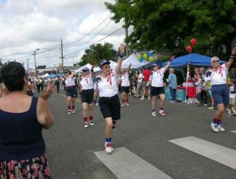
Multnomah Days, an annual neighborhood street fair, takes place every year in the summer. In the morning, an endearingly corny procession features marching bands, classic cars, clowns, and the hugely popular Tail’s End Pooch Parade, a pack of pet dogs dressed as cowboys, ballerinas, firefighters, and what have you. The above photo is a group marching in the parade.
Attractions are the convenient access to the Multnomah Arts Center (learn to paint, draw, dance, sing, play an instrument, etc.) and the Southwest Community Center (swimming, exercise classes, etc.) located in the 90 acre Gabriel Park.
A good source of information about the neighborhoods is the Multnomah Village Post, the local weekly newspaper.
History
 The neighborhood began as a land claim of Thomas and Polly-Anne Tice, and through the 1800's the area remained a densely wooded area, unnamed and home to only a few residents. H.L. Gilbert consolidated the majority of the current village into the Wildwood Subdivision. At this point, the site was bounded by the same physical streets, their names were: Fulton Boulevard, Farewell Street and Gordon Avenue. The neighborhood continued to grow and was eventually annexed to Portland over an 8-year period beginning in 1954.
The area was a stop on the Oregon Electric Railway as it traveled from Portland south to Salem in the early 1900s. It was the policy of the officials to apply native names, when ever possible, to the stations as they were established. So in 1908 when the stop was established, they gave it the name of Multnomah.
Multnomah Village was, for a long time, home to the world's first wiki, WikiWikiWeb, which was physically located in an office in the village. The Web site has since relocated. WikiWikiWeb (also known as WardsWiki) was the first wiki application ever written. It was developed in 1994 by Ward Cunningham in order to make the exchange of ideas between programmers easier and was based on the ideas developed in HyperCard stacks that he built in the late 1980s.
For more detailed information on the history of Multnomah Village, see the Multnomah Historical Association Web site.
Origin of the Name of Multnomah
According to Oregon Geographic Names, Multnomah is an Indian (Chinookan tribe) name and the word was first used by by Lewis and Clark in their journals with the style 'Mulknomah,' referring to the stream now known as the Willamette. The community of Multnomah took its name from Multnomah County.
Multnomah Home Styles
What interesting about the community is the variety of home styles. The predominate style is contemporary as most of the homes were built after WWII. In the 90s, developers started building townhomes around the village area and that trend has continued. Condos have been built within the last few years.
1Multnomah Home Prices
- Number of Homes Sold in Multnomah—► 98 homes were sold in 2012 and 9% were distressed sales. 90 homes were sold in 2011 and 26% were distressed sales. 68 homes were sold in 2010 and 7% were distressed sales.
- Median Price for Homes Sold in Multnomah—► $291,500 in 2012, $264,000 in 2011, $279,900 in 2010, $276,300 in 2009, $300,000 in 2008, and $326,000 in 2007.
- 1-Year Median Sales Price Change in Multnomah—► The change was 10% in 2012, -3% in 2011, and -2% in 2010.
- 5-Year Median Sales Price Change in Multnomah—► 2008 to 2012 the change as -4%. 2007 to 2011 the change was -19%. 2006 to 2010 the change was -1%.
- Portland Metro Area Median Home Price—► $235,000 in 2012, $221,000 in 2011, $239,900 in 2010, $247,000 in 2009, $278,000 in 2008, and $290,000 in 2007.
- Portland Metro Area Average Home Price—► $275,000 in 2012, $263,300 in 2011, $282,100 in 2010, $289,900 in 2009, $330,300 in 2008, and $342,000 in 2007.
Please be aware that the above figures are subject to error and are intended as guidelines only.
Multnomah Homes for Sale
Parks and Community Centers in the Multnomah Neighborhood
The 90-acre Gabriel Park has a wide assortment of facilities for all kinds of activities. This includes a play ground, tennis courts, off-lease dog area, trails, and large fields for soccer and baseball/software. In a corner of the park is the Southwest Community Center. It includes a basketball court, fitness room, gymnasium, kitchen, meeting room, party room, indoor swimming pool, and weight room.
The Sprout Academy is an educational preschool with a 'green' focus offered by Portland Parks & Recreation's Southwest Community Center, located in the Southwest Community Center. "Sprout" students acquire the foundations of learning, including math, science, language development, art, music, and social skills. All the while, children experience nature and learn about ecosystems, sustainable living, and caring for the environment through developmentally appropriate activities in and out of the classroom.
The Portland Parks and Recreation Department also has an Arts Center in the village area. The Multnomah Arts Center facility includes classrooms, weaving rooms with over 60 looms, a darkroom, printmaking studio with presses, dance studio, music rooms, a ceramics studio with pottery wheels, slab roller, and kilns, and an applied arts studio with sculpture and jewelry making equipment. Rentable areas include an auditorium and stage, gymnasium, dance studio, classrooms, kitchen, and kitchenette. Outdoor grounds include a covered basketball court, playground, courtyard, and parking.
Multnomah has 101 acres of park land and open spaces according to Metro and the Portland Department of Parks and Recreation.
Walking in Multnomah
The SW Trails Group is a committee of Southwest neighborhoods that uses volunteer efforts to make trail improvements, lead walks, work with Safe Routes to School, plan and advocate for pedestrian and bicycle safety and other improvements in Southwest Portland. Their walks are the second Saturday of each month.
Gabriel Park has some great trails for either a run or a walk. Some of the trails go through a wooded section of the park and others through open areas.
Walk Score helps you find a walkable place to live. Walk Score is a number between 0 and 100 that measures the walkability of any address. Portland is the 12th most walkable city in the U.S. with a Walk Score of 66 and 57% of the residents have a Walk Score of 70 or above. The Multnomah neighborhood ranks 41 out of 88 Portland neighborhoods. Below is a Walk Score for an address in the center of the neighborhood.
More About Multnomah
- Neighborhood Association Web site The neighborhood has one page on the SW Neighborhoods Web site. The SW Capitol Road neighborhood is on Facebook.
- Neighborhood News A good source of information about the neighborhoods is the Multnomah Village Post, the local weekly newspaper.
- Location About four miles south on I-5 and where the freeway jogs to the southwest − Multnomah is just to the west.
- 2Drive Time to Downtown 15 minutes.
- Topography Moderate rolling hills and wooded.
- Streets and Sidewalks Winding streets along with some grid patterns. Some of the blocks have sidewalks.
- Livability Study 94.1% of the Multnomah residents rated their neighborhood "good" or "very good." See Livability Study.
- Public Transportation TriMet has ten bus routes. The neighborhood does not have access to MAX light rail or the streetcar line. Transit Score provides a 0-100 rating indicating how well an address is served by public transportation. Ratings range from "Rider's Paradises" to areas with limited or no nearby public transportation.
- 3Census 2010 Demographics Population: 7,409. Area size: 923 acres. Average population density: 8 persons per acre. Number of households: 3,813. Average size of household: 1.94 persons. Median household income: $57,116. Families with children: 20%. Percent of home owners: 52%. Percent of renters: 48%. Diversity: 13.4% non-Caucasian: 28%. More census data about Multnomah at Portland Online.
- 4Crime Stats 15 violent crimes and three crimes per 1,000 residents in 2012. 10 violent crimes in 2011 and total crimes per 1,000 residents was 3. For the latest crime statistics for the Multnomah neighborhood, click here.
- Sex Offenders Click here for the State of Oregon Sex Offender Inquiry System. After agreeing to the "Conditions of Use Statement" you will be redirected to a "Enter Search Criteria" page. Insert a zip code in the "Zip" field and click on the "Query" button. Multnomah zip code: 97219.
-
5Shopping and Services Number of supermarkets: 1. Number of health clubs: 2. Number of coffee shops: 4.
The Village Center − main street and side streets - is like living in a small town. The village has numerous small shops and eating places. If you're a reader, visit Annie Bloom's Books - comfy armchairs, a house cat, and a complimentary cup of tea make you feel at home. You can also head over the next neighborhood, Hillsdale, to purchase anything you need but can't find in the village. - Eating Out Any local will point in the direction of Marco's Cafe and Espresso Bar. Another favorite is the Lucky Labrador Public House and O'Connors Pub. The Fat City Cafe's walls are adorned with interesting pieces of history.
- Public Library The closest library is a short drive to the east - the Hillsdale Library.
- Who Lives in Multnomah People who enjoy a sense of community with a range of housing (single family, townhomes, a few apartments). The median age in Multnomah is 34.
- Cars in the Neighborhood Small cars - Subarus are common.
- 6Biking Quality is low. Multnomah has 13 miles of bike lanes.
- Schools Elementary schools: Rieke Elementary and Maplewood Elementary. Middle school: Gray Middle. High school: Wilson.
- 7School Report Card Grades Elementary schools: O/S. Middle schools: S. High school: O. Click here for report card details.
Map of Multnomah Neighborhood
Fly to the Multnomah Neighborhood via Google Earth
Coordinates
45° 27′ 53.17″ N
122° 43′ 27.45″ W
Launch Google Earth
___________________________________
1Real Estate Values Data on real estate values provided by RMLStm. Distressed properties refer to the percentage of total homes sold that were short sales and bank-owned properties.
2Drive Time to Downtown Estimated commuting time obtained from Yahoo Maps and Google Maps. Drive time was calculated from a central intersection in each neighborhood to Pioneer Courthouse Square during the morning peak commute time.
3Demographics Data Numbers were obtained from Census 2010 and www.portlandmaps.com.
4Crime Statistics Numbers on crime were obtained from Portland Police Bureau. Violent crimes are defined as murder, rape, robbery, and aggravated assault. Crimes per 1,000 are based on reported incidents of violent crime, as well as arson, burglary, larceny, and motor vehicle theft.
5Shopping and Services Numbers were determined from local directory listings and county/municipal library systems.
6Biking Quality rating based on the 2007 Cycle Zone Analysis conducted by the City of Portland Office of Transportation. The six-tier ratings have been reduced to three levels: High, Fair, and Low.
7School Report Card Grades Schools ratings from the Oregon Department of Education 2009-2010 performance assessment. "O" = Outstanding; "S" = Satisfactory; "I" = In Need of Improvement; NR = Not Rated.
|
View
|
Multnomah
|
To learn more about the
|
Learn More
|
Fat Albert's
On weekend mornings, customers pack into this breakfast cafe, a line even spills out the door. They come for low prices and friendly service.
|

Guide to the South Portland Neighborhood in Portland, OregonCorbett, Johns Landing, Lair Hill, South Waterfront, and Terwilliger |
|||||
|
The neighborhood is found east of I-5 between the Terwilliger Curves and Willamette River. From downtown Portland this neighborhood can be reached by traveling along Naito Parkway towards the Ross Island Bridge and taking the Macadam Avenue turn off immediately before continuing across the Ross Island bridge. The neighborhood along the river is referred to as Johns Landing. South Portland is a collection of a number of different neighborhoods. Most are historic that have existed for years but one, South Waterfront, has only been around since the beginning of the 2000s. Below you will find a short history of each.
For the last few years, the area's riverfront has been converting from heavy industry to residential development at a density that is expected to double the neighborhood's population. Offices and health care facilities employing several thousand have located along the river. Who says you can't combine learning and a night out? At Jolly at Johns Landing in Southwest Portland, you can do both, an especially welcome tonic on a rainy evening when bar-hopping isn't quite an option. We're talking about trivia nights. Every Thursday at 7:30 p.m., anyone can stop by this neighborhood sports bar at 5627 S.W. Kelly Avenue and join six rounds of trivia. Bring a friend, a group of friends, some co-workers, a special someone, your parents, your grandparents. You don't have to be an expert on anything to participate. Each round consists of five to 10 questions, ranging from general knowledge to funny quotes by famous people, to films, to politicians, to album covers. In one round, Pospisil will show pictures and participants must identify who's in them. The rules are simple: You play in teams of up to seven people. The quizmaster calls out a question, and players write down the answers. The winning team gets $5 for each player. Neighborhood Icons: OHSU Tram and Gibbs Street Pedestrian Bridge
The Tram cabins travel 3,300 linear feet between the South Waterfront terminal adjacent to the OHSU Center for Health & Healing, and the upper terminal at the Kohler Pavilion on OHSU’s main campus. Traveling at 22 miles per hour, the Tram cabins rise 500 feet for the three-minute trip over I-5, the Lair Hill neighborhood and the Southwest Terwilliger Parkway. More about the tram at this link.
The City of Portland built a new bike and pedestrian bridge over I-5 that opened in July, 2012 to connect the historic Lair Hill neighborhood with the South Waterfront District. The Gibbs Street pedestrian bridge, residents of Portland’s Corbett/Lair Hill district will at last be reconnected to the city’s waterfront. The building of Interstate 5 in the early 1960s cut off parts of what is now called the South Portland neighborhood from the Willamette River. It’s only a short distance from Lair Hill to South Waterfront, but pedestrians and cyclists trying to get between the two must negotiate the freeway and other hard-to-cross, high-traffic areas such as Macadam Boulevard, Naito Parkway and the ramps for the Ross Island Bridge. But now, instead of making a circuitous, unpleasant one-mile-plus trip, pedestrians and cyclists can walk or ride over the freeway on the span of the new bridge, the official name of which is the U.S. Congresswoman Darlene Hooley Pedestrian Bridge at Gibbs Street. The bridge is being named for the retired U.S. representative who was instrumental in securing funding for the bridge and pushing the project through. HistoryThe South Portland Historic District was built between the 1870s and the 1920s and it was the home to Italian and Jewish immigrants. The area thrived in the early years since the population of Portland, all on the west side (East Portland was a separate city), was increasing rapidly and the area was a relatively easy place to develop, being a broad bench between the river and the West Hills. The first streetcars in the mid 1870s helped spur growth. The decline started in the 30s when immigrants moved on to newer, most upscale neighborhoods in Portland. In the 50s, homeowners left for the suburbs and outlying neighborhoods. In the 70s, Corbett and Lair Hill was the area to get your hash pipe and other countercultural sundries. The construction of I-5 in the 60s devoured more of the streets and long-time neighbors were now cut off. Attracted by the cheap rents, students from Portland State University, Lewis and Clark College, and Oregon Health and Science University moved in. The area was dying, full of renters, and the prospects for the neighborhood looked dim. By the 70s, the neighborhood was discovered or perhaps rediscovered. Maybe by the educated people who were its renters. Activists realized its potential − live close to downtown in a historic home and buy it for the right price. Now that bungalow, purchased in the 70s - 80s for a song and renovated, is worth 4-5 times as much. The Portland "neighborhood revolution" started in the South Portland community. The community organized in 1969 to fight the South Auditorium urban renewal project. The city wanted to clear parts of the Lair Hill neighborhood, located just south of the downtown urban renewal zone. Three other neighborhoods joined to develop their own district plan to preserve fragments of old South Portland and Fulton. This backlash resulted in establishment of the Lair Hill Historic Conservation District, the first protected historic district in Portland. This was followed by other Portland neighborhoods protesting other urban renewal projects.
As families became more affluent, many of them moved out to Laurelhurst or Irvington. And then in the late '50s and early '60s, a series of highway projects and Portland's first urban renewal program cut the neighborhood to shreds. Olsen points out two beautiful Victorians on First Avenue that are still standing. Farther North, Mosler’s Bagel Shop and many other homes and businesses were not so lucky. Origin of the Names of Corbett, Terwilliger, Lair Hill, and Johns LandingSenator Henry Winslow Corbett was one of Oregon's prominent pioneer citizens and for many years a resident of Portland. Terwil was a station on the Oregon Electric Railway and served the Terwilliger Park subdivision. William Lair Hill was a distinguished lawyer, author, and versatile writer who moved to Oregon in his youth during the early 1850s. Note that the 'Hill' in the Lair Hill neighborhood does not refer to a physical hill but to William Lair Hill. He became one of the nation's great constitutional lawyers. Johns Landing refers to the B. P. John Furniture company, the largest of many manufacturers in the area in its industrial past, as well as architect John W. Storrs and John D. Gray, who privately transformed the area into a riverside residential and commercial development. The neighborhood, formerly known as Corbett-Terwilliger-Lair Hill or CTLH, changed its name at a meeting of its neighborhood association in 2006 to be more concise and inclusive. South Portland was the name of a 19th century community that overlapped the present day neighborhood. This area was part of historical South Portland, a district of Italian, Irish, and Jewish immigrants much of which was demolished by an "urban renewal" project in 1958. South Portland Home Styles
The terrain is flat along the river and starts rising just west of Macadam Avenue so many of the homes in the hills have views of the river and Cascade Mountain range. The same holds true for the high rise condos along the river, especially those in South Waterfront. Affordable? Condos can be found in the $200s and townhomes for just over 300,000. The South Portland Historic District was added to the National Register of Historic Places in 1998. The district is roughly bounded by Arthur, Front, Grover, Hood, and Curry Streets, and Barbur Boulevard. It has 186 buildings in the 490 acre historic district. Styles include late 19th and early 20th Century American Movements as well as Victorian. 1South Portland Home Prices
Please be aware that the above figures are subject to error and are intended as guidelines only. South Portland Homes for SaleParks in the South Portland Neighborhood
Two buildings of historical interest are located in the park.The main building was constructed out of brick in 1918 in the Modified Georgian Revival style. In 1942, the State Architect's Office extensively remodeled it to serve as the Youth Administration of the Federal Security Agency. In 1949, the Park Bureau created a Junior Museum in the building, later renamed the Children's Museum, until it was relocated to the former OMSI building in Washington Park in 2001. The smaller building, the Customs House, was built in 1921 as a branch of the county library. The building, Italian Renaissance Revival, is one of seven Carnegie-funded branch libraries in Portland. It was designed by Folger Johnson, of Johnson & Wallwork, who designed four of the seven Portland Carnegie branches. The prominent arched windows and the curved entrance flanked by columns are typical of Italian Renaissance style. On the interior, a broken pediment appears below the circular window and Corinthian columns flank the wings. The library housed a collection of books in Yiddish, German, Polish, and Italian, as well as English before being converted to an art center by the Park Bureau in the early 1950s. Today the building is used as office space for PP&R staff. At the west end of the park, a sculpture of metal boulders by Bruce West represents a rock grotto which once stood in the park and provided a shady place where older men gathered on hot summer days to play chess. It was installed in 1978 and is entitled simply BW1. The Elizabeth Caruthers Park is located in the South Waterfront community and the 2.12 acre park was acquired in 2009. It includes a bocce court, paths, splash pad, and statue or public art. The park is named for Elizabeth Caruthers, an early pioneer woman who was one of the first settlers in the southern part of the young city of Portland. Elizabeth Caruthers was born in Tennessee. In 1816 she married Joe Thomas, and the couple had one son. She later rejected her married name, and in 1847 she and the son, Finice Caruthers, came to Oregon. They settled here on the banks of the river near the abandoned 1842 Johnson cabin. Under the Donation Land Claim Act of 1850, they claimed this 640-acre section. Elizabeth died in 1857 and Finice in 1860. Their deaths, without wills or heirs, led to fraudulent claims and litigation, which reached the United States Supreme Court in 1868. There the matter was resolved in a landmark decision ruling that, under the 1850 Donation Act, a woman — married or not — had the same property rights as a man. Here are two parks located on the Willamette River:
In the 90s, volunteers organized by the neighborhood association started meeting every so often on weekends to pull invasive plants out of Butterfly Park. That project has mushroomed to include a much expanded area and many partners. Visit the South Portland Riverbanks Projects Web site to learn more. South Portland has 63 acres of park land and open spaces according to Metro and the Portland Department of Parks and Recreation. Willamette Greenway Trail
Maintained by the Johns Landing Homeowners Association, the trail is wide enough (eight feet in most places) to accommodate both bikers and walkers. Many bike commuters use the trail to travel back and forth to work downtown and at OHSU. It starts south of South Waterfront and ends at the Sellwood Bridge. Along the way are a number of marinas including the Willamette Sailing Club. The river always hold some attractions such as waterfowl, sail boats, and you may even see an eagle. Trees along the river bank block views of the river along the northern part of the trail but once they shed their leaves in the fall, the river reappears. Biking to Work in PortlandTo bike from South Portland to downtown, you have two routes: Take the off-street (no motor vehicles) path along the river and then the painted bike lanes on SW Moody. The other choice is to take SW Barbur (painted bike lanes) into downtown. Download the SW Bikes Routes map for details. You can also use byCycle bicycle trip planner, a free online tool to help both new and seasoned cyclists plan safe trips through the city. This private Web site was created by cycling enthusiasts volunteering their time, with support from Metro. Here's a video about biking in Portland.
Walking in South PortlandTwo of the better walking tours in Portland is the Lair Hill tour and the Historic South Portland tour. Below are links to the guides and a brief explanation of the tours:
Laura Foster's 3.25 mile "South Portland to South Waterfront Park Loop" is the ultimate walk if you want some exercise and history. Her 2008 book, Portland City Walks is Laura's second book about walks. Her first book, Portland Hill Walks, is a treasure and many of her fans thought she would never be able to equal that gem. But she did. Laura actually has three books about walking. Her Walk There! was published in June 2008 by Metro, the Portland-area regional government, and funded by Kaiser Permanente. Walk Score helps you find a walkable place to live. Walk Score is a number between 0 and 100 that measures the walkability of any address. Portland is the 12th most walkable city in the U.S. with a Walk Score of 66 and 57% of the residents have a Walk Score of 70 or above. The South Portland neighborhood ranks 39 out of 88 Portland neighborhoods. Below is a Walk Score for an address in the center of the neighborhood. More About South Portland
Map of South Portland Neighborhood
Fly to the South Portland Neighborhood via Google Earth
Coordinates Launch Google Earth ___________________________________1Real Estate Values Data on real estate values provided by RMLStm. Distressed properties refer to the percentage of total homes sold that were short sales and bank-owned properties.2Drive Time to Downtown Estimated commuting time obtained from Yahoo Maps and Google Maps. Drive time was calculated from a central intersection in each neighborhood to Pioneer Courthouse Square during the morning peak commute time.3Demographics Data Numbers were obtained from Census 2010 and www.portlandmaps.com.4Crime Statistics Numbers on crime were obtained from Portland Police Bureau. Violent crimes are defined as murder, rape, robbery, and aggravated assault. Crimes per 1,000 are based on reported incidents of violent crime, as well as arson, burglary, larceny, and motor vehicle theft.5Shopping and Services Numbers were determined from local directory listings and county/municipal library systems.6Biking Quality rating based on the 2007 Cycle Zone Analysis conducted by the City of Portland Office of Transportation. The six-tier ratings have been reduced to three levels: High, Fair, and Low.7School Report Card Grades Schools ratings from the Oregon Department of Education 2009-2010 performance assessment. "O" = Outstanding; "S" = Satisfactory; "I" = In Need of Improvement; NR = Not Rated
|
 Long and narrow − four-miles long along the west bank of the Willamette River − is the South Portland neighborhood. Running down the north-south length of the neighborhood along the east side is Highway 43 (also called SW Macadam Avenue). About three miles of the four miles road through the neighborhood contains commercial properties − this includes retail, restaurants, shops, and an upscale food market. Macadam Avenue is a busy street, especially in the morning and late afternoon as commuters crowd the road. Traffic backs up for blocks trying to cross the Sellwood bridge. The saving grace is that the road does have a median strip that makes driving tolerable. You can view a list of the business by visiting the
 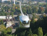 Opened in late 2006, the tram links OHSU's Marquam Hill Campus to its first building in the river blocks. The
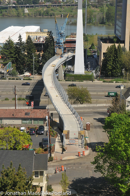
 Poina Olsen describes South Portland's population in her book entitled
  I doubt if any other neighborhood in Portland has the variety of homes that exist in the South Portland community. There are new high-rise riverfront condos, historic homes, new townhomes, apartment buildings, and newer detached single-family homes. The first homes, built in the 1870s, were mostly Victorian and home to workers at nearby docks, warehouses, and riverside industries.
 This trail is public that is on private land and runs along the Willamette River. Designed for for bikers, runners, and walkers only
Guide to the Sylvan-Highlands Neighborhood in Portland, Oregon
 This heavy wooded area just west of downtown has narrow winding streets with an absent of sidewalks. Its attraction is the quick drive to downtown and its closeness to the Oregon Zoo and Hoyt Arboretum trails.
Many of the houses that now face Highway 26 are from the 1930s and 1940s, when houses were built along the south edge of the neighborhood near the Portland Racquet Club. The rest of the neighborhood sprang up in the 1950s, '60s and '70s. And the change continues as new condos and townhomes are being constructed on the western edge of the neighborhood.
The neighborhood association supported the tunnel for light rail, which could have run above ground through the residential area. Residents also expressed concerns when the Oregon Department of Transportation began to redesign the U.S. 26 highway between Sylvan and Camelot Court, including a new overpass bridge. The overpass project now has a bridge with stanchions at each end that read 'Sylvan' on a background of trees. The design that came from the neighborhood.
You see a few of the Sylvan-Highlands residents walk from their homes to the MAX Light Rail stop at the Zoo to either head into downtown for work or out to the west suburbs for work in one of the high-tech companies.
Origin of the Name of Sylvan-Highlands
The word 'sylvan' is derived from Silvanus, the Roman deity of the woods. The name seems appropriate for an area that is more like a forest than an urban neighborhood.
Sylvan-Highlands Home Styles
You will find a few older homes along with 50s - 60s homes which is the predominant style. Homes facing west have a view of the coastal mountain range. The last few years have seen some new condos being built along with townhomes.
Most homes in Sylvan-Highlands are owner occupied. An apartment complex is located at the south end of the neighborhood near the business district. Most of the detached single-family homes are owner occupied.
1Sylvan-Highlands Home Prices
- Number of Homes Sold in Sylvan-Highlands—► 22 homes were sold in 2012 and 18% were distressed sales. 30 homes were sold in 2011 and 57% were distressed sales. 14 homes were sold in 2010 and 36% of these were distressed sales.
- Median Price for Homes Sold in Sylvan-Highlands—► $372,325 in 2012, $304,705 in 2011, $427,500 in 2010, $500,000 in 2009, $530,000 in 2008, and $585,000 in 2007.
- 1-Year Median Sales Price Change in Sylvan-Highlands—► The change was 22% in 2012, -27% in 2011, and -15% in 2011.
- 5-Year Average Sales Price Change in Sylvan-Highlands—► 2008 to 2012 the change was -13%. 2007 to 2011 the change was -43%. 2006 to 2010 the change was 14%.
- Portland Metro Area Median Home Price—► $235,000 in 2012, $221,000 in 2011, $239,900 in 2010, $247,000 in 2009, $278,000 in 2008, and $290,000 in 2007.
- Portland Metro Area Average Home Price—► $275,000 in 2012, $263,300 in 2011, $282,100 in 2010, $289,900 in 2009, $330,300 in 2008, and $342,000 in 2007.
Please be aware that the above figures are subject to error and are intended as guidelines only.
Sylvan-Highlands Homes for Sale
Parks and Gardens in the Sylvan-Highlands Neighborhood
Hoyt Arboretum (232 acres) offers ten miles of walking trails and adjoins the neighborhood. Washington Park with its numerous attractions also borders the Sylvan-Highlands neighborhood.
Sylvan-Heights has 67 acres of park land and open spaces according to Metro and the Portland Department of Parks and Recreation.
Walking in Sylvan-Highlands
The SW Trails Group is a committee of Southwest Neighborhoods Inc that uses volunteer efforts to make trail improvements, lead walks, work with Safe Routes to School, plan and advocate for pedestrian and bicycle safety and other improvements in SW Portland Their walks are the second Saturday of each month, meet at 9 a.m. sharp under the Hillsdale Oak, behind the Dance Studio at SW Sunset Blvd and SW Capitol Highway near the concrete bleachers of the Wilson football field.
Hoyt Arboretum (232 acres) offers ten miles of walking trails and adjoins Washington Park and borders the Sylvan-Highlands neighborhood. The Arboretum's plant collection is made up of over 8,000 individual trees and plants, representing over 1,000 species, many of which are accessible and well-labeled.
Walk Score helps you find a walkable place to live. Walk Score is a number between 0 and 100 that measures the walkability of any address. Portland is the 12th most walkable city in the U.S. with a Walk Score of 66 and 57% of the residents have a Walk Score of 70 or above. The Sylvan Highlands neighborhood ranks 84 out of 88 Portland neighborhoods. Below is a Walk Score for an address in the center of the neighborhood.
More About Sylvan-Highlands
- Neighborhood Association Web site Sylvan-Highlands.
- Location Take West Burnside out of downtown and when you approach Skyline Boulevard, look to your left.
- 2Drive Time to Downtown About ten minutes - more if you're traveling West Burnside during rush hour.
- Topography Moderate rolling hills, very wooded, winding roads. Very few homes have views.
- Streets and Sidewalks Not a straight street in the neighborhood and no sidewalks.
- Livability Study 96.3% of the Sylvan-Highlands residents rated their neighborhood "good" or "very good." The survey data for this neighborhood was combined with Forest Park and Northwest Heights. See Livability Study.
- Public Transportation TriMet has four bus routes in the neighborhood. Number 20 goes up Burnside Road, and Nos. 58 and 63 go to the Sylvan overpass. A MAX light rail stop at the Oregon Zoo is within walking distance for residents living on the east side of the neighborhood. Transit Score provides a 0-100 rating indicating how well an address is served by public transportation. Ratings range from "Rider's Paradises" to areas with limited or no nearby public transportation.
- 3Census 2010 Demographics Population: 1,317. Area size: 697 acres. Average population density: One person per acre. Number of households: 575. Average size of household: 1.94 persons. Median household income: $117,641. Families with children: 23.2%. Percent of home owners: 86%. Percent of renters: 14%. Diversity: 9.6% non-Caucasian. More census data about Sylvan-Highlands at Portland Online.
- 4Crime Stats Two violent crimes and two crimes per 1,000 residents in 2012. Three violent crimes in 2011 and total crimes per 1,000 residents was 2. For the latest crime statistics for the Sylvan-Highlands neighborhood, click here.
- Sex Offenders Click here for the State of Oregon Sex Offender Inquiry System. After agreeing to the "Conditions of Use Statement" you will be redirected to a "Enter Search Criteria" page. Insert a zip code in the "Zip" field and click on the "Query" button. Sylvan-Highlands zip code(s): 97021, 97025.
- 5Shopping and Services This neighborhood has a few commercial establishments on SW Skyline Boulevard. You will find a convenience store, cleaners, a couple of gas stations, and a pizza take-out. It is an easy 7-8 minute drive to the Northwest District where you will find all kinds of shopping.
- Eating Out Pizzicato, a well-regarded pizza take-out is located at the intersection of Highway 26 and SW Skyline Boulevard. Residents are minutes from restaurants in Northwest District and downtown.
- Walking Score Most of the addresses have a walking score in the 40s (not walkable) as recorded by Walk Score.
- Public Library You have to go downtown to the Multnomah County Central Library or to the Northwest District branch located at 2300 NW Thurman Street.
- Who Lives in Sylvan-Highlands With its proximity to downtown, the Sunset Highway, freeways and the light-rail line, Sylvan Highlands has attracted a diverse group of residents. Former Governor Tom McCall lived in the neighborhood when he worked for The Oregonian and Channel 8. Median age is 45. It has the second highest median household income among the 95 Portland neighborhoods. Once you live in Sylvan-Highlands you stay as 69% of the residents have live in their home since 2004 or earlier.
- Cars in the Neighborhood SUVs, luxury autos, and a few vans (soccer moms).
- 6Biking Quality is low. The neighborhood has seven miles of bike lanes.
- Schools Elementary schools: Ainsworth Elementary and Chapman Elementary. Middle school: East-West Sylvan. High school: Lincoln High School.
- 7School Report Card Grades Elementary schools: O. Middle school: O. High school: O. Click here for report card details.
Map of Sylvan-Highlands Neighborhood
Fly to the Sylvan-Highlands Neighborhood via Google Earth
Coordinates
45° 30′ 57.84″ N
122° 44′ 33.48″ W
Launch Google Earth
_____________________________________________
1Real Estate Values Data on real estate values provided by RMLStm. Distressed properties refer to the percentage of total homes sold that were short sales and bank-owned properties.
2Drive Time to Downtown Estimated commuting time obtained from Yahoo Maps and Google Maps. Drive time was calculated from a central intersection in each neighborhood to Pioneer Courthouse Square during the morning peak commute time.
3Demographics Data Numbers were obtained from Census 2010 and www.portlandmaps.com.
4Crime Statistics Numbers on crime were obtained from Portland Police Bureau. Violent crimes are defined as murder, rape, robbery, and aggravated assault. Crimes per 1,000 are based on reported incidents of violent crime, as well as arson, burglary, larceny, and motor vehicle theft.
5Shopping and Services Numbers were determined from local directory listings and county/municipal library systems.
6Biking Quality rating based on the 2007 Cycle Zone Analysis conducted by the City of Portland Office of Transportation. The six-tier ratings have been reduced to three levels: High, Fair, and Low.
7School Report Card Grades Schools ratings from the Oregon Department of Education 2009-2010 performance assessment. "O" = Outstanding; "S" = Satisfactory; "I" = In Need of Improvement; NR = Not Rated.
|
View
|
Sylvan-Highlands Boundaries
U.S. 26 forms the south boundary for the neighborhood, with West Burnside Road marking the north end. The west edge of Washington Park is the east boundary and the Washington County line is the west.
Map Showing Sylvan-Highlands BoundariesSylvan Highlands |
To learn more about the
|
Learn More
|
Sylvan-Highlands Modern
This 1966 home was the winner of the AIA Portland Chapter Award of Merit '66 and AIA Sunset Western Home Awards '67/68. |