| Subscribe to the Moving to Portland Newsletters |
53°F
52°F / 70°F
54°F / 58°F
51°F / 57°F
Guide to the Arlington Heights Neighborhood in Portland, Oregon
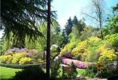 Arlington Heights, one of Portland's most scenic neighborhoods, is near city center, giving residents easy access to the spectacular Portland International Rose Test Gardens and all of Washington Park attractions. Arlington Heights is a veritable museum of architectural styles. Ranging from Victorian cottage to the latest contemporary dwellings, these homes are graced by lovely gardens and spectacular views. This is an old neighborhood with 60 percent of the homes built before 1939.
Arlington Heights is a large area (579 acres) with about 700 residents. The reason for the large acreage is because Washington Park (410 acres) lies within its boundaries. Many of the streets offer a convenient access to the ten miles of trails in the 183 acre Hoyt Arboretum. Walk to the Japanese Gardens as well as to the Oregon Zoo. Arlington Heights residents can walk to work (all downhill) and take the bus home. Some even ride their bike to work. If you're up for it, you can hike down to one of the many restaurants on Northwest 21st and 23rd Avenue and enjoy an evening meal. You just have to remember the uphill walk home.
History of Arlington Heights: A Neighborhood in the Park
Arlington Heights is situated on the Tualatin mountain range. It was once part of a conifer forest, mainly composed of Western hemlock. The presence of broad-leafed deciduous trees, not to mention roads and houses, is evidence that the area has been disturbed within the last hundred years. The landscape is hilly, dissected, and fairly steep, yet not quite steep enough to be regarded as a mountain.
What was true of the hill on which Portland Heights is now located, as described by pioneer John Talbot's daughter in a 1914 The Oregonian interview, almost certainly was true of Arlington Heights just to the north. When Portland became a city in 1851, the hill was "forest land, with cougar and panther waiting to drop down out of the dark firs." By 1890, due to the "great wind of 1880 and the labors of Chinese logging gangs," it was no longer a forest. Arlington Heights was logged of its conifers in the late 1890s and into the early 1900s.
Jane Hofmann, a resident of Arlington Heights for many years, wrote the history of the neighborhood in the late 70s. Click here to download the document.
Origin of the Name Arlington Heights
The derivation of the name Arlington Heights is not known for certain but we can speculate. Arlington had previously been applied to an 1889 plat of a tract that's now the site of the Westgate Office Complex at Sylvan. In 1905, that Arlington Heights was renamed Concord Heights. The Arlington Club's present building in Goose Hollow was completed in 1910. In 1910, Dorr Keasey and his wife, Evalyn, purchased a large tract of land in present day Arlington Heights and they may have wished to avail themselves of the prestige that Arlington conveyed. A third possibility is that Keasey wanted to honor his wife's Virginia family roots where a community by the name of Arlington is located just across the Potomac River from Washington DC .
The community was originally called Melina Heights. In about 1888 the King Real Estate Association platted an area from SW Tichner Drive to the tennis courts by the Rose Garden and from SW Wright Avenue to SW Champlain Drive. They named it Melinda Heights as Amos King's wife was named Melina. Amos was the founder of the King Real Estate Association.
Reservoirs 3 and 4 are in a Historic District
 Washington Park's two reservoirs and its gatehouse were built in the late 1800s as major facilities of the water system that first provided Portland drinking water from the Bull Run Watershed. The structures were designated as a historic district in 2004. Mount Tabor Park also has reservoirs to supply the eastside neighborhoods with water and Reservoirs 1, 5 and 6 are in a separate historic district. The Washington Park 95 acre historic district has five buildings, four structures, and the two reservoirs which are known as Reservoir 3 and 4. The style of the structures is Romanesque.
Approaching the neighborhood by foot or from a motor vehicle from the east (SW Park Place), Reservoir 3 can be seen from the road or paths. The reservoir makes a striking impression as seen in the photo. There are stairs leading down to the reservoir and walkers are allowed to hike around the reservoir which is about a quarter-mile in length. A wrought iron fence was installed in 2008 which adds to the beauty of the reservoir.
All of the Portland reservoirs are open. After 9-11, the federal government wanted all open water sources to be covered or buried. Portland city officials went along with the proposal but the citizens of Portland mobilized and fought the idea − they wanted to keep the reservoirs open. Today the reservoirs still remain open and undergo a constant, 24/7 surveillance by armed guards. But the struggle goes on as the city and federal government are convinced that open reservoirs are unsafe.
For more information about the reservoirs, visit the Friends of the Reservoirs Web site.
Arlington Heights Home Styles
You will find Cottage, English, Tudors, and a few ranch homes that were built in the 50s and 60s. Stilt homes have been built on steep hills in the last 20-30 years. The neighborhood has a number of homes on the National Register of Historic Places. This is the list as of 2009:
- A.H. Maegly House at 226 SW Kingston Street. This is a Prairie style home.
- Abraham Tichner House at 114 SW Kingston Avenue. The architectural style of this home is Classical Revival.
- 2910 SW Canterbury Lane: Canterbury Castle (also known as the Arlington Castle) J.O. Frye was the architect of this home as well as the J.O. Frye House. The Castle was demolished in 2009 due to structural damages.
- 2959 SW Bennington Drive: Digman-Zidell House. The architectural style of this home is Mission/Spanish Revival.
- 2997 SW Fairview Boulevard: J.O. Frye House (also known as the Fariss House as well as the “Spider House” because of the leaded windows resembling a spider web).
- 337 SW Kingston Avenue: Matthew and Florence Lynch House and Garden. The architectural style is Colonial Revival.
From 1911-1919, only nineteen houses were built in the neighborhood. During the post-war boom years, 1920-1929, one hundred houses were built. The Depression caused a big drop in construction: only twenty-three houses were built from 1930-1939. Even today, new homes are being constructed on hillsides that in years past would have been too steep to build on but modern technology allows for construction.
1Arlington Heights Home Prices
- Number of Homes Sold in Arlington Heights—► 17 homes sold in 2012 and 6% were distressed sales. 13 homes sold in 2011 and 8% were distressed sales. 19 homes sold in 2010 and 11% were distressed properties sales.
- Median Price for Homes Sold in Arlington Heights—► $490,000 in 2012, $650,000 in 2011, $630,000 in 2010, $655,000 in 2009, $694,900 in 2008, and $750,000 in 2007.
- 1-Year Median Sales Price Change—► 2011 to 2012 the sales price change was -25%. 2010 to 2011 the sales price change was 2%. 2009 to 2010 the sales price change was -4%.
- 5-Year Median Sales Price Change in Arlington Heights—► 2008 to 2012 the sales price change was -29%. 2007 to 2011 the sales price change was -15%. 2006 to 2010 the sales price change was -9%.
- Portland Metro Area Median Home Price—► $235,000 in 2012, $221,000 in 2011, $239,900 in 2010, $247,000 in 2009, $278,000 in 2008, and $290,000 in 2007.
- Portland Metro Area Average Home Price—► $275,000 in 2012, $263,300 in 2011, $282,100 in 2010, $289,900 in 2009, $330,300 in 2008, and $342,000 in 2007.
Please be aware that the above figures are subject to error and are intended as guidelines only.
Arlington Heights Homes for Sale
- View Arlington Heights homes currently for sale by clicking here
- View Arlington Heights recent home sales by clicking here
Parks and Gardens in the Neighborhood
 Located just minutes west of downtown, Washington Park (130 acres) is one of the most used parks in Portland. The city purchased the original 40.78 acres in 1871 from Amos N. King for $32,624. Many people questioned the purchase given that the population of Portland at the time was only 8,000 and the site was thick with brush and timber, and cougars roamed the hills. The site was inaccessible until years later when logging and the installation of a cable car made the park accessible. Early in the 1900s, sentiment began to change and Portland's forefathers were heralded for their long-range vision.
A bronze statue of Sacajawea holding her son Jean-Baptiste is located near the east entrance to the park. In commemoration of the heroic Shoshone Indian woman who helped lead the Lewis and Clark explorers through the mountains of the west, the statue was unveiled on July 7, 1905 at the Lewis and Clark Centennial. Among those present at the event were Susan B. Anthony, Abigail Scott Duniway, and Eva Emery Dye. Hidden among the trees, the Coming of the White Man statue was completed in 1904. The bronze statue, sculpted by Hermon A. MacNeil and cast by Bureau Brothers Foundry in Los Angeles, features two Native Americans standing on a block of rough-hewn native stone. Facing eastward, they look down upon the route that ox teams trudged bringing settlers to this part of the country.
Entering the park's east entrance via SW Park Place/SW Lewis Clark Way are these two attractions:
- Reservoirs There are stairs leading down to Reservoir3 and walkers are allowed to hike around the reservoir which is about a quarter-mile in length. The reservoirs are a historic district.
- Holocaust Memorial The memorial is the park newest attraction and it was dedicated on August 29, 2004. The memorial features a stone bench adorned with wrought-iron gating, screened from the street by rhododendron bushes. The bench sits behind a circular, cobblestoned area simulating a town square.
These are the attractions all within the area of the International Rose Garden:
- International Rose Garden With over 8,000 rose plantings, the garden attracts about 750,000 visitors annually. Many come to the Rose Garden to marry and to have their wedding pictures taken. The Rose Garden offers a magnificent view point overlooking the city and Cascade Range.
- Rose Garden Store Portland's very own rose-themed specialty shop. In order to qualify to be in the shop, each piece of merchandise must "look like a rose, smell like a rose, taste like a rose, have a rose on it, hold a rose in it, or be for or about growing roses."
- Children Playground The popular, accessible play area (sand boxes, swings, jungle jims, etc.) was built in 1995 by the Portland Rotary Club. It is located just around the corner from the International Rose Garden and on the original site of the Oregon Zoo.
- Train to the Zoo The Washington Park Run goes through the forests of Washington Park to a station above the International Rose Test Garden and back to the zoo. In the early 50s, hundreds of volunteers built five miles of track and kids bought zoo-railway shares for a dollar each and copies of the book, Clickety Clack and the Bandits. Watch a video of the train ride.
- Japanese Garden At the heart of a Japanese garden is harmony with nature. These peaceful spots in the Garden lend themselves to meditation and contemplation. The 5.5 acre Japanese Garden is composed of five distinct garden styles. View a video of the garden by clicking here.
These are found all within a few blocks of each other and located at the far west side of Washington Park:
- Oregon Zoo The Zoo celebrated its 100th birthday in 1987. Packy put Portland on the map in 1962 when he made international news for being the first elephant born in the Western Hemisphere in over 44 years.
- Portland Children Museum The mission of Portland Children's Museum is to inspire imagination, creativity and the wonder of learning in children and adults by inviting moments of shared discovery. The Museum is now the sixth oldest children’s museum in the country, and each year the Museum welcomes more than 245,000 children from birth to age ten and their caregivers.
- Forestry Discovery Center Founded in 1964, the World Forestry Center's mission is to educate and inform people about the world's forests and trees, and their importance to all life, in order to promote a balanced and sustainable future.
- Vietnam Memorial The curved black granite wall lists the names of all Oregon residents who died in Vietnam or who are missing in action. The wall also chronicles three years of the conflict and concurrent local events, providing a poignant contrast.
Hoyt Arboretum lies on the west side of the Arlington Heights neighborhood. The 232 acre wooded site possesses the largest group of distinct species of any arboretum in the U.S. Its plant collection contains 10,000 individual trees and shrubs, representing nearly 1,000 different species from around the world. The arboretum is a favorite place for hikers and runners with its 10 miles of trails. The Wildwood Trail is part of the 40-Mile Loop and passes through Hoyt Arboretum. The Wildwood leads into Forest Park on the north side and into the Council Crest Trail by the Oregon Zoo. Go to Forest Park Conservancy for Forest Park trail information.
The park also includes an archery range, soccer field, amphitheater, tennis courts, picnic sites, and restrooms. During the summer months, TriMet, the regional public transportation organization, operates a shuttle bus that circles through the park. Click here to view a map of the park.
Arlington Heights has 323 acres of park land and open spaces according to Metro and the Portland Department of Parks and Recreation.
Zoobombers and Skate Boarders
On children's bikes that have been customized − banana seats, swooping handle bars, mini-wheels − "Zoobombers" whoosh down SW Fairview Boulevard from the Oregon Zoo and into the Arlington Heights neighborhood. The skate boarders often take side streets off of SW Fairview Boulevard for a more thrilling ride. After passing through the neighborhood, they enter the Goose Hollow neighborhood where they catch a ride on the MAX Light Rail line back to the zoo and repeat their performance. It's downhill all the way from the Zoo to the Goose Hollow MAX stop − a drop of about 500 feet or so in a two mile run.
The Zoobombers' make their most frequent appearance on Sunday evenings − skate boarders are out at all times of the day and evening. Arlington Heights residents are divided about the disturbance and safety issues along with the entertainment that the Zoobombers and boarders create; many are disturbed by the noise (skates making contact with the road and Zoobombers shouting out their rallying cry, "zoobomb") especially those that live along the route the bombers and boarders use. Whether it's working with TriMet to extend their Washington Park MAX stop hours, or sitting down with the Police to share concerns and work through issues, Zoobomb has worked hard to become a recognized and respected Portland tradition and most concerns with the Zoobombers appear to have been resolved. It's a different story with the skate boarders. You can catch a video of the bombers and of the skate boarders.
The Arlington Heights Neighborhood Association in late 2011 tackled the skate boarding problem by arranging meetings with the police, reps from the boarders, and board members to resolve the issue. One of the main concerns for Arlington Heights residents is the safety issue as boarders often appear out of' 'no where' when the residents are driving in the neighborhood.
The Arlington Heights Yahoo Discussion board reported some positive developments on the skateboard front in July 2012.
- The city posted signs, one at Knights & Fairview and the other on Madison Drive. by the reservoirs, asking skaters to skate more responsibly and quietly. The plan is to install two more: one at the Goose Hollow Max station and one in the elevator at the Washington Park Max station.
- The city distributed brochures to several skate shops that attempt to deliver a similar message.
- Some of the skaters we've been meeting with have started to organize a group of "Hill Monitors", skaters who will wear orange vests and attempt to engage other skaters in the neighborhood about skating responsibly.
- The police have promised to mount a couple of targeted enforcement efforts in the coming weeks, to cite skaters for traffic violations. Unfortunately, under current law, the maximum fine for a skater is $25, while fines for similar violations by bikes or cars are $260. Still, it's a start.
- Some of the skaters have put up a Web site aimed at educating skaters about responsible skating. Watch the "Safety Huey" video, which sends a very positive message and appears to be getting wide circulation already.
The City Council passed a rule in September 2012 prohibiting skateboarding on certain streets from 10 p.m. until 7 a.m. Other regulations for skateboarders throughout the city include skateboarders younger than 16 are required to wear helmets, everyone must use lights at night, and being caught blowing a stop sign costs $260.
Walking in Arlington Heights
Hoyt Arboretum with 10 miles of walking trails is in the middle of the neighborhood and most residents can be on the trails within 1-3 blocks of their homes. Walkers also find many exciting opportunities to get off the concrete and blacktop and pursue walking on more natural and yielding surfaces, such as sand, grass, gravel, snow, and mud. The Wildwood Trail in Hoyt Arboretum (also in Forest Park) boasts some of the finest mud around for a few months of the year before turning to hard-packed dirt, making for some amazing and ever-changing walking terrain. Click here for a trail map. Other neighborhood walks include:
- Reservoir 3 is nestles in the quiet, scenic hills of Washington Park. Enjoy a quarter-mile walk around this tranquil resource.
- Come early April, you will want to catch the first Magnolias in bloom. Click here to download the guide.
- Laura Foster's Portland Hill Walks book is available from Timber Press here in Portland. The book has a walk through the streets of Arlington Heights.
Walk Score helps you find a walkable place to live. Walk Score is a number between 0 and 100 that measures the walkability of any address. Portland is the 12th most walkable city in the U.S. with a Walk Score of 66 and 57% of the residents have a Walk Score of 70 or above. The Arlington Heights neighborhood ranks 72 out of 88 Portland neighborhoods. Below is a Walk Score for an address in the center of the Arlington Heights neighborhood.
Rose Garden Summer Concerts
During August the Portland Parks Department presents a series of concerts in the amphitheater at the International Rose Garden. Many of the Arlington Heights residents pack up a picnic dinner and head for the concert. The program runs the gamut from Brazilian, jazz, cowboy, and classical. You'll see kids dancing (many with their older sibling or parents) in front of the performers under the warm August Portland skies. Below is a video of one of the performances, the Portland Festival Orchestra.
More About Arlington Heights
- Neighborhood Association Web Site Click here to access the Arlington Heights neighborhood Web site. They also have a Yahoo Discussion Group. Join the group by sending an email to This email address is being protected from spambots. You need JavaScript enabled to view it. .
- Location of Neighborhood West of downtown - it takes about 5-6 minutes to cross I-405 and be downtown. A five minute drive to be in the Northwest shopping area.
- 2Drive Time to Downtown 7-9 minutes. Some residents bike to work downtown and take the bus home to avoid the 500 plus foot climb.
- Topography Moderate to steep hills and winding streets. Mature trees and woods.
- Street and Sidewalks All the side streets are narrow and many cars park partially on the sidewalks. Most of the streets have sidewalks although the walks are narrow on the side streets.
- Livability Study 96.4% of Arlington Heights residents rated their neighborhood "good" or "very good." See Livability Study.
- Public Transportation Bus route 63 connects downtown with Washington Park and Arlington Heights and there are four other lines all on the perimeter (i.e., West Burnside) of the community. A MAX light rail has a stop at the Oregon Zoo which is consider part of the Arlington Heights neighborhood. Residents living on the west side of the neighborhood can walk over to the MAX light rail stop at the Oregon Zoo and catch a ride to work. Transit Score provides a 0-100 rating indicating how well an address is served by public transportation. Ratings range from "Rider's Paradises" to areas with limited or no nearby public transportation.
- 3Census 2010 Demographics Population: 1,905. Area in acres: 579. Average population density: 1 persons per acre (includes vacant spaces). Number of households: 307. Average size of household: 2.34. Median household income: $114,325. Home owners: 74%. Renters: 5%. Diversity: 10.0% non-Caucasian. More census data about Arlington Heights at Portland Online.
- 4Crime Stats In 2012 there were two violent crimes and eight crimes per 1,000 residents. Four violent crimes in 2011 and crimes per 1,000 residents was 8. For the latest crime statistics for the Arlington Heights neighborhood, click here.
- Sex Offenders Click here for the State of Oregon Sex Offender Inquiry System. After agreeing to the "Conditions of Use Statement" you will be redirected to a "Enter Search Criteria" page. Insert a zip code in the "Zip" field and click on the "Query" button. Arlington Heights zip code: 97205.
- 5Shopping and Services The only retail establishments are the Rose Garden gift shop, Hoyt Arboretum gift shop, and the Japanese Garden gift shop. If residents want to shop, it means getting into your car and driving a few minutes to the Northwest District or downtown. Or you can do what 80 plus-year-old Arlington Heights resident Annie does. She walks down to Trader Joe's or Fred Meyer, does her shopping and takes the number 63 bus back home.
- Eating Out Its means getting into the family car and driving a few minutes to the Northwest District or downtown. If you're a walker, you can make it down to the Northwest District (10-12 restaurants) but it will take much longer to walk back as an elevation gain of 300 - 500 feet.
- Public Library You have to go downtown to the Multnomah County Central Library or to the Northwest District branch located at 2300 NW Thurman Street. Both are a 8-9 minute drive.
- Who Lives in Arlington Heights Married couples in their 30s and upward, couples with teen-age children, about 20 percent of the households have children under 18. Median age is 46.
- Cars in the Neighborhood View homes will have an luxury sedan such as a Audi, BMW, Mercedes, or Volvo. The second car is an SUV. Pickups are rare except for the local Chevy dealer as he has his choice for the "Vehicle of the Day" and one occasion he will take a pickup off the lot and drives it home. I counted nine Toyota hybrids driving through the neighborhood one day.
- 6Biking Quality is rated low. Arlington Heights has eight miles of bike lanes.
- Schools Elementary school: Ainsworth. Middle school: East-West Sylvan. High school: Lincoln High School.
- 7School Report Card Grades Elementary school: O. Middle school: O. High school: O. Click here for report card details.
Map of the Arlington Heights Neighborhood
Fly to the Arlington Heights Neighborhood via Google Earth
___________________________________
1Real Estate Values Data on real estate values provided by RMLStm. Distressed properties refer to the percentage of total homes sold that were short sales and bank-owned properties.
2Drive Time to Downtown Estimated commuting time obtained from Yahoo Maps and Google Maps. Drive time was calculated from a central intersection in each neighborhood to Pioneer Courthouse Square during the morning peak commute time.
3Demographics Data Numbers were obtained from Census 2010 and www.portlandmaps.com.
4Crime Statistics Numbers on crime were obtained from Portland Police Bureau. Violent crimes are defined as murder, rape, robbery, and aggravated assault. Crimes per 1,000 are based on reported incidents of violent crime, as well as burglary, larceny, and motor vehicle theft.
5Shopping and Services Numbers were determined from local directory listings and county/municipal library systems.
6Biking Quality rating based on the 2007 Cycle Zone Analysis conducted by the City of Portland Office of Transportation. The six-tier ratings have been reduced to three levels: High, Fair, and Low.
7School Report Card Grades Schools ratings from the Oregon Department of Education 2009-2010 performance assessment. "O" = Outstanding; "S" = Satisfactory; "I" = In Need of Improvement; NR = Not Rated.
|
View
Arlington Heights |
Arlington Heights Boundaries
To the north, West Burnside; to the east and south, the outer boundaries of Washington Park; and to the west the outer boundaries of Hoyt Arboretum.
Map Showing Neighborhood Boundaries Arlington Heights
|
To learn more about the
|
Aaron H. Maegly House
This Prairie School style home was designed by architect John V. Bennes. It is located at 226 SW Kingston Street in the Arlington Heights neighborhood. |


Guide to the Forest Park Neighborhood in Portland, Oregon

Built along a ridge northwest of downtown and only 10-15 minutes from the attractions of the Northwest District, it combines rolling green pastures and views east and west. The Forest Park neighborhood is named because of its proximity to the 5,000 plus acre Forest Park, the southern portion of which lies within the neighborhood boundaries and the rest of which is adjacent. Most of the neighborhood lies within unincorporated Multnomah County, though it does include some areas within Portland city limits.
If you desire the "look and feel" of a suburban community but want to be close to downtown, examine the Forest Park neighborhood closely.
The 600 acre development named Forest Heights is located to the southwest of the Forest Park neighborhood - it is in Washington County. It is commonly referred to as the "Intel Country Club" because so many of the Intel engineers who work in Hillsboro live in Forest Heights.
Forest Park is a great place to bring up a family as some of the best schools in Oregon are located in the neighborhood. For example, the Forest Park Elementary has been rated "exceptional" since 2004. See the latest State of Oregon Department of Education Report Cards.
Origin of the Name Forest Park
The neighborhood is located adjacent to the 5,000 plus acre City of Portland Forest Park.
Forest Park Home Styles
Diversity in homes styles and sizes are the attraction. Townhomes under 2,000 square foot to 3,000 plus square foot detached single-family homes are found in Forest Park. Most have been constructed in the last ten years and the area is still being developed. Many of the homes have views of the coast range to the West and are within walking distance of the 5,127 acre Forest Park which is on the east side of the elongated neighborhood (about 5 miles in length).
1Forest Park Home Prices
- Number of Homes Sold in Forest Park—► 15 homes sold in 2012 and 13% were distressed sales. 21 homes sold in 2011 and 10% were distressed sales. 17 homes sold in 2010 and 24% were distressed properties sales.
- Median Price for Homes Sold in Forest Park—► $608,000 in 2012, $570,000 in 2011, $600,000 in 2010, $610,000 in 2009, $655,000 in 2008, and $762,500 in 2007.
- 1-Year Median Sales Price Change in Forest Park—► 2011 to 2012 the sales price change was 7%. 2010 to 2011 the sales price change was -5%. 2009 to 2010 the sales price change was -2%.
- 5-Year Median Sales Price Change in Forest Park—► 2008 to 2012 the sales price change was -24%. 2007 to 2011 the sales price change was -32%. 2006 to 2010 the sales price change was -29%.
- Portland Metro Area Median Home Price—► $235,000 in 2012, $221,000 in 2011, $239,900 in 2010, $247,000 in 2009, $278,000 in 2008, and $290,000 in 2007.
- Portland Metro Area Average Home Price—► $275,000 in 2012, $263,300 in 2011, $282,100 in 2010. $289,900 in 2009. $330,300 in 2008, and $342,000 in 2007.
Please be aware that the above figures are subject to error and are intended as guidelines only.
Forest Park Homes for Sale
Walking in Forest Park: 70 Miles of Trails
 Portland's Forest Park is the 14th largest city park in the United States and some authorities say it is the largest wooded park in the country. Covering 5,000 plus acres, it provides a hushed and peaceful environment of a varied and evolving forest ecosystem. Overlooking the Willamette River, the Park stretches for nearly eight miles along the northeast slope of the Tualatin Mountains between NW Skyline Boulevard and NW St. Helens Road (Hwy. 30).
Forest Park is home to over 100 species of mammals: more than 100 kinds of birds have been seen in the Park. In the spring, hillsides sparkle with trilliums amidst the sword ferns; hundreds of other kinds of flowers and shrubs bloom during the year.
The Park offers enjoyment to hikers, bicyclists, runners, and others who just enjoy being outdoors in a forest atmosphere. The 30+ mile long Wildwood Trail (a National Recreational Trail) traverses the Park from the Vietnam Veterans' Memorial in Hoyt Arboretum to Newberry Road. A total of more than 70 miles of interconnecting trails and lanes provide opportunities for circle hikes of varying length.
Forest Park has 4,794 acres of park land and open spaces according to Metro and the Portland Department of Parks and Recreation. Much of the wooded city park (Forest Park) is part of the neighborhood.
A Father and His Son Hike Forest Park
This video is a father and son hiking Forest Park. Miles of trails serve bikers, hikers, and casual strollers. One of the most popular hikes is the portion of the Leif Erikson trail that begins at the end of NW Thurman Street. A wide, leafy fire trail with a gradual uphill grade, you can bike or walk the trail. It's also a popular place for runners.
See the Friends of Forest Park Web site for more information. Forest Park is on Facebook.
Walk Score helps you find a walkable place to live. Walk Score is a number between 0 and 100 that measures the walkability of any address. Portland is the 12th most walkable city in the U.S. with a Walk Score of 66 and 57% of the residents have a Walk Score of 70 or above. Below is a Walk Score for an address in the center of the neighborhood.
More About Forest Park
- Neighborhood Association Web Site Web site Forest Park Neighborhood.
- Location of Neighborhood It rests on the west side of Forest Park between NW Barnes on the south, Newberry Road on the north and the Washington County line on the west.
- 2Drive Time to Downtown 18-19 minutes.
- Topography Moderate to very hilly. It is a heavily wooded area and many homes have views of the Coastal Mountain Range.
- Streets and Sidewalks Void of sidewalks except along Miller Road in Forest Heights. The streets leading to the developments can be winding and narrow.
- Livability Study 96% of Forest Park Heights residents rated their neighborhood "good" or "very good." See Livability Study.
- Public Transportation Forest Park has three bus lines - visit the TriMet Web site. No MAX light rail or streetcar lines in Forest Park. Transit Score provides a 0-100 rating indicating how well an address is served by public transportation. Ratings range from "Rider's Paradises" to areas with limited or no nearby public transportation.
- 3Census 2010 Demographics Population: 3,081 people. Area (acres): 11,961. Average population density: 0.35 per acre. Number of households: 1,611. Average household size: 2.41. Median income of household: $112,666. Home owners: 82%. Renters: 18%. Diversity: 14.3% non-Caucasian. More census data about Forest Park at Portland Online.
- 4Crime Stats In 2012 there were three violent crimes and three crimes per 1,000 residents. Four violent crimes in 2011 and crimes per 1,000 residents was 3. For the latest crime statistics for the Forest Park neighborhood, click here.
- Sex Offenders Click here for the State of Oregon Sex Offender Inquiry System. After agreeing to the "Conditions of Use Statement" you will be redirected to a "Enter Search Criteria" page. Insert a zip code in the "Zip" field and click on the "Query" button. Forest Park zip code(s): 97210, 97229, 97231.
- 5Shopping and Services These neighborhood is void of any retail establishments but it is a short drive to a small mall (corner of SW Barnes Road and NW Miller Road) with a QFC supermarket, Starbucks, cleaners, pizza, vet, etc. Residents are about 10-15 minutes from the Northwest District as well as a larger mall just off NW Cornell Road. In Forest Heights (southwest of the neighborhood), the area's first commercial site is been developed at NW Miller Road and NW Mill Ridge. It has a grocer and Starbucks.
- Eating Out The Skyline Restaurant is located at 1313 NW Skyline Boulevard and it attracts locals and outsiders. The Skyline is reasonably price but don't expect gourmet food. For an evening meal, the closest food source is the Outback Steakhouse at 11146 SW Barnes Road.
- Public Library You have to go downtown to the Multnomah County Central Library or to the Northwest District branch located at 2300 NW Thurman Street.
- Who Lives in Forest Park Young professionals who usually are married. Only 14.4 percent of the households have one person living in them. The median age is 40. The median household income of $112,666 from the 2010 census makes the community one of the top three highest in Portland.
- Cars in the Neighborhood Safe family cars. The second car is usually a SUV or a sporty car for Dad to drive to work.
- 6Biking Quality is low. Forest Park has 37 miles of bike lanes.
- Schools Elementary school: Forest Park. Middle school: East-West Sylvan. High school: Lincoln High School.
- 7School Report Card Grades Elementary schools: O. Middle schools: O/S. High schools: O/S. Click here for report card details.
Map of Forest Park Neighborhood
Fly to the Forest Park Neighborhood via Google Earth

Coordinates
45° 35′ 15.80″ N
122° 50′ 24.75″ W
Launch Google Earth
________________________________________________
1Real Estate Values Data on real estate values provided by RMLStm. Distressed properties refer to the percentage of total homes sold that were short sales and bank-owned properties.
2Drive Time to Downtown Estimated commuting time obtained from Yahoo Maps and Google Maps. Drive time was calculated from a central intersection in each neighborhood to Pioneer Courthouse Square during the morning peak commute time.
3Demographics Data Numbers were obtained from Census 2010 and www.portlandmaps.com.
4Crime Statistics Numbers on crime were obtained from Portland Police Bureau. Violent crimes are defined as murder, rape, robbery, and aggravated assault. Crimes per 1,000 are based on reported incidents of violent crime, as well as burglary, larceny, and motor vehicle theft.
5Shopping and Services Numbers were determined from local directory listings and county/municipal library systems.
6Biking Quality rating based on the 2007 Cycle Zone Analysis conducted by the City of Portland Office of Transportation. The six-tier ratings have been reduced to three levels: High, Fair, and Low.
7School Report Card Grades Schools ratings from the Oregon Department of Education 2009-2010 performance assessment. "O" = Outstanding; "S" = Satisfactory; "I" = In Need of Improvement; NR = Not Rated.
|
View
|
Forest Park
|
To learn more about the
|
Learn More
|
Forest Park Home
This is a typical home in Forest Park. It has a 3-car garage and over 3,500 square feet of living space. It has hardwood floors, cherry cabinets, granite countertops, stainless appliances, wainscoting, crown moldings, three fireplaces, and a large master suite. |

Guide to the Hillside Neighborhood in Portland, Oregon
Also Known as Kings Heights
 This part of Northwest Portland lies upon a portion of the Tualatin Mountains that overlook downtown Portland. with the 5,000-acre plus Forest Park immediately to the west (Macleay Park is a part of Forest Park) and the shops and restaurants of Northwest Portland at the foot of the neighborhood immediately to the east, there is easy access to both urban amenities and the beauties of nature. Downtown Portland is minutes away.
The promoters of the original Westover development called the area "the finest residential section in the United States." The Westover developers' plan to terrace the hill, then known as "Scotch Nubbin", so that they could build homes. That was completed in 1914 and homes started to be built. Since then the neighborhood has grown to approximately 575 households.
The above photo is a view looking east from King's Heights
Origin of Name King's Heights
How Hillside got its name is unknown but we can assume because it is on a hillside. The neighborhood is commonly known as King's Heights. About 1852, Amos Nahum King purchased the rights to 513 acres and part of the property included the Hillside neighborhood. That part of the property up in the hills in the Northwest area soon became known as King's Heights. Amos' acreage also include the neighborhoods of Northwest District (aka Nob Hill), Arlington Heights, Goose Hollow, among others.
King's Heights/Hillside Home Styles
 Many homes have a view of the city or mountains like the photo above. Some can see the ships lying to the northeast on the Willamette River. Most of the homes on the steep, winding streets are gracious older homes, generally without much of a yard. Some condominium complexes have been built in the lower reaches of the neighborhood. This is expensive real estate and most homes are in the million and above range.
You will find English Tudor, Queen Ann Victorian, Colonial, and Foursquare homes in the neighborhood. Contemporary homes that are built on steep lots using modern building technology are evident.
The photo is of the Henry Hahn house in King's Heights and was designed by noted local architect Emil Schacht. The home was built in 1906 and it is one of Portland’s best examples of the Arts & Crafts style.
1Hillside Home Prices
- Number of Homes Sold in Hillside—► 76 homes sold in 2012 and 13% were distressed sales. 81 homes sold in 2011 and 15% were distressed sales. 43 homes sold in 2010 and 16% were distressed properties sales.
- Median Price for Homes Sold in Hillside—► $510,500 in 2012, $502,000 in 2011, $639,000 in 2010, $577,500 in 2009, $683,050 in 2008, and $740,000 in 2007.
- 1-Year Median Sales Price Change in Hillside—► 2011 to 2012 the sales price change was 2%. 2010 to 2011 the sales price change was -21%. 2009 to 2010 the sales price change was 0%H
- 5-Year Median Sales Price Change in Hillside—► 2008 to 2012 the sales price change was -30%. 2007 to 2011 the sales price change was -32%. 2006 to 2010 the sales price change was -7%.
- Portland Metro Area Median Home Price—► $235,000 in 2012, $221,000 in 2011, $239,900 in 2010, $247,000 in 2009, $278,000 in 2008, and $290,000 in 2007.
- Portland Metro Area Average Home Price—► #275,000 in 2012, $263,300 in 2011, $282,100 in 2010, $289,900 in 2009, $330,300 in 2008, and $342,000 in 2007.
Please be aware that the above figures are subject to error and are intended as guidelines only.
Hillside/King's Heights Homes for Sale
Parks and Community Centers in Hillside
 Macleay Park is a natural area for hiking located at NW 29th Avenue and Upshur Street. It was acquired in 1897 and has a history bordering on the Appalachians "Hatfields and McCoys." Danford Balch was the original owner and settler of this area. He arrived in Oregon in 1847 and settled his donation land claim in 1850. A nearby claim was taken by the Stump family. The two families did not care for each other. Mortimer Stump, the eldest son of the clan, began courting Anna, the oldest of the Balch daughters. Danford warned Mortimer to stay away from his fifteen-year-old daughter, but Mortimer paid no heed. When Anna turned sixteen, she and Mortimer ran away to Vancouver, Washington, where they eloped. Two weeks later, Danford took his shotgun and met members of the Stump family, including his new son-in-law, at the Stark Street Ferry. As the ferry was loading, Danford shot both barrels into Mortimer, who died instantly. On October 17, 1859 he was hanged at a public gallows in front of over 500 witnesses. The creek that runs through the property bears his name because for years after his hanging people still referred to the area as the Old Balch Place. The property was eventually acquired by Donald Macleay, a prominent Portland merchant. Hence the name of Macleay Park.
The Hillside Community Center facilities includes classrooms, gymnasium, tennis courts, soccer field, outside play area, kitchen, and office.
The story of how the Community Center started tells one a lot about the character of the neighborhood. Owned by an art school who could not afford its upkeep, the building was about to be sold to developers. Residents felt that the site would be better used as a park and community center. The problem, of course, was money. The community was given a year to raise $106,500 to purchase the land and the buildings on it. After an exhaustive neighborhood fundraising effort, plus contributions from the City Council and private foundations, the community was still $25,000 short. To make up the difference, twelve families took out second mortgages on their homes to guarantee the loan that finalized the purchase. This group was known as the 'Trembling Twelve.' In spring of 1974, the neighbors turned the property over to the City of Portland, which accepted it as a public park and agreed to maintain it and staff a community center there.
Hillside has 124 acres of park land and open spaces according to Metro and the Portland Department of Parks and Recreation.
Hillside's Treasure: Pittock Mansion
 The Pittock Mansion was home to Portland pioneers Henry and Georgiana Pittock from 1914 to 1919. During the late 1800s and the early 1900s, their lives and work paralleled the growth of Portland from a small Northwest town site to a thriving city with a quarter million population. With its eclectic architectural design and richly decorated interior, including family artifacts, the Pittock Mansion stands today as a living memorial of this family’s contributions to the blossoming of Portland and its people.
English-born Henry Lewis Pittock journeyed on a wagon train from Pennsylvania to Oregon in 1853 where, at the young age of 19, and in his own words, “barefoot and penniless,” he began working for Thomas Jefferson Dryer’s Weekly Oregonian newspaper. In 1860, at the age of 26, he married 15-year-old Georgiana Martin Burton of Missouri. A consummate businessman, Henry Pittock took ownership of the Weekly Oregonian in 1860, changing its format to the daily paper we read today. He went on to build an empire incorporating real estate, banking, railroads, steamboats, sheep ranching, silver mining, and the pulp and paper industry.
Henry and Georgiana were at the pinnacle of their successful lives when they commissioned architect Edward Foulkes to design and build their new home overlooking Portland, the city they loved. They began planning and designing their new home in 1909. The mansion was completed in 1914, replete with stunningly progressive features including a central vacuum system, intercoms, and indirect lighting. The threat of demolition at the hands of land developers, and the extensive damage caused by a storm in 1962, brought concerned citizens together to raise funds to preserve the site. Seeing this popular support, and agreeing that the house had tremendous value as a unique historic resource, the City of Portland purchased the estate in 1964 for $225,000. Fifteen months were spent restoring it. The mansion opened to the public in 1965, and has been a community landmark ever since.
The mansion is located in the Hillside neighborhood and it is open to the public. Below is a video of many area of Portland to include a brief tour of the Pittock Mansion.
Walking in the Hillside Neighborhood
The 5,000 plus acre Forest Park borders the King's Heights neighborhood on the west and its 70 miles of trails are used daily by many of the King's Heights residents.
We recommend Laura Foster's Portland Hill Walks book. It's no ordinary guidebook as it contains no restaurant ratings, no rehashed explanations of how the city got its name. Instead, in twenty meandering, view-studded strolls from forested canyons to cityscape peaks, this lively travelogue answers questions you may never have thought to ask. It's available from Timber Press here in Portland. The book includes lots of city history, while pointing out fun ways to get to know your backyard.
Walk Score helps you find a walkable place to live. Walk Score is a number between 0 and 100 that measures the walkability of any address. Portland is the 12th most walkable city in the U.S. with a Walk Score of 66 and 57% of the residents have a Walk Score of 70 or above. The Hillside neighborhood ranks 50 out of 88 Portland neighborhoods. Below is a Walk Score for an address in the center of the neighborhood.
More About Hillside
- Hillside Neighborhood Association Visit the Hillside Neighborhood Association to learn more about the neighborhood. This site is seldom updated so expect old information.
- Location of Neighborhood Look directly West into the hills while shopping and browsing along NW 23rd Avenue and you're see the Hillside neighborhood.
- 2Drive Time to Downtown Ten minutes.
- Topography Winding roads that go up and down - very hilly. Mature trees in yards in parks.
- Streets and Sidewalks Most of the streets are narrow and winding. Sidewalks are fairly common.
- Livability Study 96% of Hillside residents rated their neighborhood "good" or "very good." See Livability Study.
- Public Transportation TriMet serves the Hillside neighborhood with three bus routes. No MAX light rail or streetcar lines in Hillside. Transit Score provides a 0-100 rating indicating how well an address is served by public transportation. Ratings range from "Rider's Paradises" to areas with limited or no nearby public transportation.
- 3Census 2010 Demographics Population: 2,200 persons. Area size in acres: 448. Average population density: 4 persons per acre. Number of households: 1,190. Average size of household: 1.85 persons. Median household income: $125,206. Homeowners: 81 Renters: 18%. Diversity: 7.9% non-Caucasian. More census data about Hillside at Portland Online.
- 4Crime Stats There were no violent crimes in 2012 and three crimes per 1,000 residents. No violent crime in 2011 and total crimes per 1,000 people was 3. For the latest crime statistics for the Hillside neighborhood, click here.
- Sex Offenders Click here for the State of Oregon Sex Offender Inquiry System. After agreeing to the "Conditions of Use Statement" you will be redirected to a "Enter Search Criteria" page. Insert a zip code in the "Zip" field and click on the "Query" button. Arlington Heights zip code: 97210.
- 5Shopping and Services Hillside does not have any services in the neighborhood. Just minutes away in the Northwest District, Hillside residents can shop at a large supermarket along with numerous specialty shops. Besides the large food markets such as Zupan's and Fred Meyers, Northwest residents shop at Trader Joe's on NW Glisan Street, City Market on NW 21st Avenue, and Elephant's Delicatessen just off West Burnside. It also has a couple of good bakeries along with a meat market.
- Eating Out It all lies at the bottom of the hills and just minutes from the homes. The Northwest District offers numerous restaurants. Urban Spoon rates over 100 restaurants, coffee places, and sandwich shops in the Nob Hill neighborhood.
- Public Library The closest library is the Northwest District Branch located at 2300 NW Thurman Street.
- Who Lives in Hillside With an median household income just under $100,000, Hillside residents are mostly professional white-collar workers. Median age is 49.
- Cars in the Neighborhood Audis, BMWs, Mercedes, and other luxury autos along with a second car which is usually a SUV.
- 6Biking Quality is rated low. Hillside has seven miles of bike lanes.
- Schools Elementary school: Chapman. Middle school: East-West Sylvan. High school: Lincoln High School.
- 7School Report Card Grades Elementary school: O Middle school: O. High school: O. Click here for report card grades.
Map of Hillside Neighborhood
Fly to the Hillside Neighborhood via Google Earth
Coordinates
45° 31′ 42.56″ N
122° 42′ 12.09″ W
Launch Google Earth
______________________________________________
1Real Estate Values Data on real estate values provided by RMLStm. Distressed properties refer to the percentage of total homes sold that were short sales and bank-owned properties.
2Drive Time to Downtown Estimated commuting time obtained from Yahoo Maps and Google Maps. Drive time was calculated from a central intersection in each neighborhood to Pioneer Courthouse Square during the morning peak commute time.
3Demographics Data Numbers were obtained from Census 2010 and www.portlandmaps.com.
4Crime Statistics Numbers on crimes were obtained from Portland Police Bureau. Violent crimes are defined as murder, rape, robbery, and aggravated assault. Crimes per 1,000 are based on reported incidents of violent crime, as well as burglary, larceny, and motor vehicle theft.
5Shopping and Services Numbers were determined from local directory listings and county/municipal library systems.
6Biking Quality rating based on the 2007 Cycle Zone Analysis conducted by the City of Portland Office of Transportation. The six-tier ratings have been reduced to three levels: High, Fair, and Low.
7School Report Card Grades Schools ratings from the Oregon Department of Education 2009-2010 performance assessment. "O" = Outstanding; "S" = Satisfactory; "I" = In Need of Improvement; NR = Not Rated.
|
View
|
Hillside Boundaries
North: NW Cornell Road.
|
To learn more about the
|
Learn More
|
Hillside House
This Colonial style home in Hillside has 3,357 square feet of living space, four bedrooms, and 3.5 baths. |

Guide to the Southwest Hills Neighborhood in Portland, OregonPortland Heights and Council Crest |
||||
|
HistoryThis area is where John B. Talbot first claimed land in 1851. Although Portland Heights is one of the oldest and most exclusive neighborhoods in Portland mainly because of its views and closeness to downtown, the area did not develop until the early 1900s. It was just too difficult to navigate the muddy roads. Once the roads were paved and the Vista Bridge was built in 1903, land prices quickly went from a few hundred dollars an acres to $10,000 by 1910. The flatter area around the midpoint of Vista Avenue, known as "The Grid," did attract residents to build summer cottages in the 1800s but those quickly disappeared and replaced by Colonials, Tudors, and other styles popular at the time when the area was developed. The Portland Cable Railway started running a cable car up Vista Avenue to Council Crest Park in 1890. An amusement park was built on Council Crest in 1907 and continued operation until 1929. The city bought the land in 1936 and created Council Crest Park. Origin of the Name of Council CrestCouncil Crest got its name in 1898 from a group of delegates to a Congregational Church council who climbed the 1,073-foot hill and promptly named it after their gathering. Most likely the "Heights" in Portland Heights came about like all the other "Heights" names in the West Hills (e.g., Arlington Heights, King's Heights, Willamette Heights, etc.). Or perhaps it was the fact that Portland Heights offered a view of the city of Portland from the "Heights." Southwest Hills Home StylesPortland's Everclear musical group has a song with the line, "I will buy you that big house, way up in the West Hills." Everclear is from Portland and they are referring to the West Hills where Everclear's founder Alexakis lived in the late 90s. He actually lived in Portland Heights. The song got it right because Portland Heights has big homes as well as some of the most sought after home in the metro area. Over the years, they have almost been recession proof, offering owners a small but fairly consistent increase in value. Southwest Hills homes have two attractions: downtown is only a short drive away and many of the homes have spectacular views. When you have a view of more than one mountain, such as Mt. Hood and St. Helens, it's called a two-mountain view. When these homes go on the market, the ad reads, "mountain view during the day and city view at night."
Portland Heights has a few condos whereas Council Crest is all detached single-family homes. 1Southwest Hills Home Prices
Please be aware that the above figures are subject to error and are intended as guidelines only. Southwest Hills (Portland Heights and Council Crest) Homes for Sale
Parks in the NeighborhoodThe neighborhood has four parks. Here's a rundown on each:
In July 1956, a welded, sheet bronze drinking fountain featuring a mother and child was installed in the park. Sculpted by Frederic Littmann, an associate professor of art at Portland State College, it has been mistakenly identified as a pioneer woman. The sculptor said the statue did not represent a particular era; it was simply a mother and child playing in the park and depicts joy. The photo at the top of this page is the pioneer woman. Council Crest Park is one of the highest points in the metro area at 1,071 feet above sea level. On a clear day, the view from Council Crest is unbeatable. You can view many of the highest peaks in the Cascade Range. From the top of the hill, one can see five mountains in the Cascade Range: Mt. Hood, Mt. St. Helens, Mt. Adams, Mt. Jefferson, and Mt. Rainier (100 miles to the north). In addition, the park boasts a fantastic 180 degree view of Portland and surrounding towns. Southwest Hills has 164 acres of park land and open spaces according to Metro and the Portland Department of Parks and Recreation. Cable Cars
A streetcar line to the top of Council Crest was completed in 1906. It was the most scenic and spectacular streetcar line in the Northwest because once at the top, you have views of the Cascade Mountain Range. The photo to the left is one of the streetcars. The 'cow catcher' (aka a bumper) in front of the car reads, "See Portland from Council Crest."
Walking in the Southwest Hills Neighborhood
Walk Score helps you find a walkable place to live. Walk Score is a number between 0 and 100 that measures the walkability of any address. Portland is the 12th most walkable city in the U.S. with a Walk Score of 66 and 57% of the residents have a Walk Score of 70 or above. The Southwest Hills neighborhood ranks 78 out of 88 Portland neighborhoods. Below is a Walk Score for an address in the center of the neighborhood. More About Southwest Hills
Map of Southwest Hills
Fly to the Southwest Hills Neighborhood via Google Earth
Coordinates Launch Google Earth __________________________________________
|
 Southwest Hills includes two well known neighborhoods: Portland Heights and Council Crest. Look into the west and slightly south from level ground in downtown and your eyes balls will be tilted upwards towards the hills of Portland Heights. Leaving downtown on West Burnside and heading south on Vista Avenue and after crossing the Vista Bridge (over Highway 26), you will began to notice stately homes. You're in Portland Heights. Travel further southwest past the Ainsworth Elementary School and the next stop is the neighborhood of Council Crest.
 This charming Colonial in Portland Heights was built in 1916 and is one of the oldest homes on SW Sherwood Drive. It's a good example of the type of home that can be found in the neighborhood. The main level is welcomes you into a formal living room and beautiful dining room, both featuring grand fireplaces and quarter-sawn oak floors. The ‘green apple’ kitchen retains the old-house charm, but was recently renovated with all the modern conveniences, including antiqued granite counter tops. From the downstairs basement to the top of the third floor, this very spacious and beautifully-designed home showcases a traditional style, updated to accommodate the needs of contemporary family life.
 The "crown jewel" of the Council Crest neighborhood is the 43-acre
  The Portland Heights trestle opened in 1890 and paved the way for people to live in the Southwest Hills neighborhood. The trestle went all the way up to SW Spring Street which begins by the Ainsworth Elementary School.
|
View
|
Southwest Hills
|
To learn more about the Southwest Hills neighborhood
|
Learn More
|