| Subscribe to the Moving to Portland Newsletters |
54°F
47°F / 63°F
53°F / 70°F
55°F / 58°F
Goose Hollow
Guide to the Goose Hollow Neighborhood in Portland, Oregon

According to Dr. Tracy Prince's book Portland's Goose Hollow, Goose Hollow is "one of Portland's oldest neighborhoods, Goose Hollow is steps from downtown and beloved for its quirky character, historic homes, spectacular views, and walkability. Over a century ago, the actual "hollow" was dramatically altered when the meandering Tanner Creek, in a deep gulch with several trestle bridge crossings, was diverted underground and infilled. The creek's presence is still felt in the ravine carved through the Tualatin Mountains (spanned by the Vista Bridge) and in the neighborhood's identity."
While the neighborhood has now less than half the housing stock it had thirty years ago, it remains one of the most densely populated parts of the city. Its attractiveness as a place to live has much to do with this association's insistence on maintaining a pedestrian environment and rebuilding a community focus lost in a period of dislocation and changing patterns of urbanization accompanying the development of urban freeways. Recent trends are toward rebuilding the neighborhood's housing stock with new units exceeding demolitions in the 1990's.
While the neighborhood has now less than half the housing stock it had thirty years ago, it remains one of the most densely populated parts of the city. Its attractiveness as a place to live has much to do with this association's insistence on maintaining a pedestrian environment and rebuilding a community focus lost in a period of dislocation and changing patterns of urbanization accompanying the development of urban freeways. Recent trends are toward rebuilding the neighborhood's housing stock with new units exceeding demolitions in the 1990's.
Goose Hollow is host to a number of community and regional institutions. Three of these neighborhood landmarks are highly visible: Lincoln High School, Multnomah Athletic Club, and Jeld Wen Field
The Westside MAX public art program added the vision of over 20 artists to the planning and design of the light-rail system, resulting in the installation of over 100 art elements along the Westside line. Here in Goose Hollow many residents, students and businesses contributed to the art found at the Civic Stadium, Kings Hill and Goose Hollow stations. View the art at the MAX Train Web site
History of Goose Hollow
 The Goose Hollow Foothills League Neighborhood Association is host to five historic residential communities. These consist of an uptown area of older brick apartment houses and residential hotels, mixed with commercial and light industrial activities that we have called the Lownsdale area. Another area called Kings Hill once hosted the residences of Portland's turn of the century wealthier merchants, now partly infilled with higher density apartments and offices.
Goose Hollow itself, is the site of a creek, long since buried, that was the primary residence for a substantial goose population in the late nineteenth century. It is an outskirt of downtown that mixed commercial, residential, industrial, and highway commercial activities in an area that had been family farms and Portland suburbs before the automobile.
Gander Ridge and Vista Ridge are at the foot of Portland Heights and at the edge of the bowl that makes downtown Portland and Goose Hollow.
Tracy Prince's book, Portland's Goose Hollow (see above book cover), "uncovers the little-known history of one of Portland's oldest and most-loved neighborhoods. The book's foreword is written by legendary character, former mayor, and Goose Hollow resident Bud Clark. The book provides definitive answers to how Goose Hollow got its name and how Tanner Creek, long since buried. Stories are also told of the Great Plank Road, City Park's slow-moving landslide, and famous residents such as Daniel Lownsdale, C. E. S. Wood, Dr. Marie Equi, John Reed, and Bud Clark. Historic institutions such as Civic Stadium, Multnomah Athletic Club, Lincoln High School, and Washington Park are also featured."
Origin of the Name Goose Hollow
Goose Hollow was named after the geese that were allowed to roam freely throughout the neighborhood and in the 20 block long — 2 block wide — 50' deep Tanner Creek Gulch (now infilled). A gulch is also known as a hollow. Conflicts over the free-ranging geese were called Goose Wars.
Goose Hollow Home Styles
 Goose Hollow has every type of home to include apartment buildings, condos, townhomes, and a few detached single-family homes (many of these are listed on the National Register of Historic Places). Some apartment buildings have been converted into condos and new condos were also built in the 2000s. The west side of the neighborhood has some beautiful historic large homes. Over 80 percent of the residents reside in an apartment and this number is increasing. Much of the apartment living is by students at Portland State University which is just across the I-405 freeway from Goose Hollow. The 2000 census: 67.1% of the households have one person per household.
The King's Hill Historic District is bounded by W. Burnside Street, SW Canyon Road, SW 21st Street and Washington Park. Within the 430 acre historic district are 105 buildings to include many homes. The styles of these homes include Late Victorian, late 19th and early 20th Century American Movements, and late 19th and 20th Century Revivals.
1Goose Hollow Home Prices
- Number of Homes Sold in Goose Hollow—► 90 homes sold in 2012 and distressed property sales were 34%. 73 homes sold in 2011 and distressed properties sales were 32%. 66 homes sold in 2010 and distressed properties sales were 26%. Most homes sold in Goose Hollow are condos.
- Median Price for Homes Sold in Goose Hollow—► $229,450 in 2012, $200,000 in 2011, $312,500 in 2010, $282,500 in 2009, $292,000 in 2008, and $279,300 in 2007.
- 1-Year Median Sales Price Change in Goose Hollow—► 2011 to 2012 the change was 15%. 2010 to 2011 the change was -31%. 2009 to 2010 the change was 15%.
- 5-Year Median Sales Price Change in Goose Hollow—► 2008 to 2012 the change was -24%. 2007 to 2011 the change was -28%. 2006 to 2010 the change was 16%.
- Metro Area Median Home Price—► $235,000 in 2012, $221,000 in 2011, $239,900 in 2010, $247,000 in 2009, $278,000 in 2008, and $290,000 in 2007.
- Metro Area Average Home Price—► $275,000 in 2012, $263,300 in 2011, $282,100 in 2010, $289,900 in 2009, $330,300 in 2008, and $342,000 in 2007.
Please be aware that the above figures are subject to error and are intended as guidelines only.
Homes for Sale in Goose Hollow
Parks and Health Clubs in Goose Hollow
 Jeld-Wen Field (former PGE Park) is a sports facility located on the north edge of Goose Hollow. Jeld-Wen is home to Portland Timbers professional soccer team. The Timbers joined the Major League Soccer (MLS) in 2011. The former multi-purpose stadium was renovated in 2010-2011 for soccer and football at a cost of $31 million.
The stadium was originally built in 1926 and has undergone a number of transformations over the years. Not only is the stadium home to the Timbers, but a number of other teams and events call Jeld-Wen Field home. Portland State University plays its home football games at Jeld-Wen and Portland State women’s soccer program also plays a number of games at the stadium.
The Multnomah Club is a private health and social club located next to PGE Park and its facility is about 350,000 square feet. It has multiple swimming pools, gyms, and restaurants. Undoubtedly the premier health club in the metro area, the drawback is getting a membership into the club. They use a lottery system for adding new members.
Washington Park is located on the west edge of Goose Hollow and you will find many Goose Hollow residents running, hiking, and enjoying all of its attractions.
Goose Hollow has one acre of park land and open spaces according to Metro and the Portland Department of Parks and Recreation.
MAX Line Makes Living Easy in Goose Hollow
A benefit of living in Goose Hollow is the access to the MAX Light Rail trains. They comes rolling right through the neighborhood. Whether you commute to downtown or west to Beaverton or Hillsboro, it's a easy walk down the to a MAX stop from most parts of the neighborhood. If you work downtown, you could walk to work downtown or bike very easily. If you don't want to take the MAX or walk, there's bus service in the community.
Local Institutions: Goose Hollow Inn and Leaky Roof Pub & Grill
 The name alone will entice you to stop in for a pint and sandwich: Leaky Roof! Here is what the Portland Monthly Magazine had to say about the pub: "If this modest beer house and eatery were any better camouflaged, even bloodhounds would have trouble sniffing it out. Tucked inside a bland yellow bungalow on SW Jefferson St, the Leaky Roof has been tracking Goose Hollow foot traffic since 1947. The cozy corner bar has a fair number of beers and assorted spirits, but the wall of whiskey draws the most attention."
You can lunch with former Portland Mayor Bud Clark at his Goose Hollow Inn. As mayor, "Bud" Clark created the nationally recognized 12-Point Homeless Plan, supported the growth of mass transit, including the MAX Light Rail line to Hillsboro, Oregon, aided downtown development, and initiated and led the campaign to build the Oregon Convention Center. Clark also sanctioned The Mayor's Ball, an annual charity event featuring independent musicians from all over the Northwest. It could be argued that The Mayor's Ball was instrumental in building a music scene that helped to fuel the Nineties' grunge movement.
The tavern owner served eight years (1985 - 1992) and now has returned to running his tavern called Goose Hollow Inn. It has a pleasant deck where you can drink away your frustrations with the rest of the City Hall roustabouts. The Hollow's Reuben sandwich is always a winner. The Goose Hollow is located at 1927 SW Jefferson Street.
Money Magazine: Goose Hollow is one of the Best Places to Retire
The October 2007 issue of Money Magazine named the Goose Hollow neighborhood as one of the best places to retire. The article states that, "Goose Hollow is walking distance to Washington Park, which is home to the Japanese Garden, the International Test Rose Garden and the Hoyt Arboretum. As one of the original residential areas in Portland, Goose Hollow is marked by turn-of-the-century homes."
Goose Hollow Video
Here's a video of life in Goose Hollow. It's a bit artsy with music in the background but very entertaining. It's fun getting a look at the neighborhood buildings and haunts.
Walking in Goose Hollow
Here are some walking tours in the downtown area of Portland:
- Public Art Walking Tour The Regional Arts & Culture Council (RACC) along with the Portland Oregon Visitors Association have a Public Art Walking Tour map/brochure – a colorful guide to nearly 100 public art pieces in downtown Portland and the near eastside. This free brochure is available at Portland-area visitor centers, or by calling RACC at (503) 823-5111. You can also download a copy by clicking here.
- Walking Tour to Pittock Mansion This 2.8-mile walk begins in Northwest Portland and climbs some of the city's longest staircases through Westover Heights. It ends at the Pittock Mansion, a restored French Renaissance Revival chateau. The home, its grounds, and fabulous views are open to the public. Click here to download the guide.
- Walking Tour Nob Hill and the Pearl District This 3.3-mile walk begins at PGE Park it takes you through historic neighborhoods to shops, galleries, restaurants, and theaters in the Pearl District and Nob Hill. Click here to download the guide.
Walk Score helps you find a walkable place to live. Walk Score is a number between 0 and 100 that measures the walkability of any address. Portland is the 12th most walkable city in the U.S. with a Walk Score of 66 and 57% of the residents have a Walk Score of 70 or above. The Goose Hollow neighborhood ranks eighth out of 88 Portland neighborhoods. Below is the Walk Score for Jeld-Wen Field in Goose Hollow.
More About Goose Hollow
- Neighborhood Association Web Site Goose Hollow Foothills League.
- Location West of downtown. When you cross I-405, you're in Goose Hollow. The streets are all "Southwest" and if they say "Northwest", you are in the Northwest District neighborhood.
- 2Drive Time to Downtown Five to six minutes.
- Topography Flat with mature trees in yards and parks. A slight rise in elevation going from east to west.
- Sidewalks and Streets Goose Hollow has sidewalks for walking except for some winding roads in the south part of the neighborhood. Most of the streets have parked cars lining them.
- Livability Study 90.5% of Goose Hollow residents rated their neighborhood "good" or "very good." See Livability Study.
- Public Transportation TriMet has 11 bus routes in Goose Hollow. The MAX light rail line rolls right through the center of the neighborhood (three stops). No streetcars in Goose Hollow. Transit Score provides a 0-100 rating indicating how well an address is served by public transportation. Ratings range from "Rider's Paradises" to areas with limited or no nearby public transportation.
- 3Census 2010 Demographics Population: 6,507. Area size: 279 acres. Average population density: 23 persons per acre (includes vacant spaces). Number of households: 4,778. Average size of household: 1.36 persons. Median household income: $48,376. Home owners percent: 20%. Renters percent: 80%. Diversity: 15.6% non-Caucasian. More census data about Goose Hollow at Portland Online.
- 4Crime Stats 21 violent crimes and crimes per 1,000 residents was seven in 2012. There were 22 violent crimes and total crimes per 1,000 residents was 49 in 2011. For the latest crime statistics for the Goose Hollow neighborhood, click here.
- Sex Offenders Click here for the State of Oregon Sex Offender Inquiry System. After agreeing to the "Conditions of Use Statement" you will be redirected to a "Enter Search Criteria" page. Insert a zip code in the "Zip" field and click on the "Query" button. Goose Hollow zip code(s): 97201, 97205, 97209.
- 5Shopping and Services Number of supermarkets: 1. Number of health clubs: 1. Number of coffee shops: 6. These numbers are somewhat misleading as residents have access to numerous food markets just across West Burnside to include Fred Meyer, Zupan's, Trader Joe's on NW Glisan, Whole Foods closer to downtown, and City Market on NW 21st Avenue.
- Farmers Markets The Wednesday market is held between Southwest Salmon and Main streets. 10 am-2 pm Wednesdays, May-October. The Saturday market is held at the South Park Blocks by PSU between Southwest Harrison and Montgomery streets. 8:30 am-2 pm Saturdays, March-December. The Northwest District/Nob Hill farmer is between Northwest 19th Avenue and Everett Street, 3 pm-7 pm Thursdays, June-September. Pioneer Courthouse Square is held 10:00 am-2:00 pm on Mondays from June-December. More information at Portland Farmers Market.
- Eating Out Most residents hike across Burnside to the Northwest District or downtown. If you want food in Goose Hollow you can get the best Reuben sandwich on the West Coast at the Goose Hollow Inn located at 1927 SW Jefferson Street. The Hotel deLuxe has a restaurant — called Gracie’s after comedian Gracie Allen — and serves breakfast, lunch and dinner. It is located at 729 SW 15th Avenue. Most residents head across Burnside and dine in the Nob Hill neighborhood.
- Public Library It is just a few blocks (801 SW 10th Avenue) to the Multnomah County Central Library in downtown Portland.
- Who Lives in Goose Hollow Students from Portland State University who rent, young folks who want to be close to downtown, and empty nesters who like condo living. About two-thirds of the residents are under 40 years of age. The median age is 36.
- What They Drive in Goose Hollow SUVs and luxury autos at the detached single-family homes and a mix of autos at apartments and condos. Many Portland State University students bike to class.
- 6Biking Quality is high. Goose Hollow has four miles of bike lanes.
- What's in the Recycle Bin Pinot Noir wine bottles and Tanqueray gin on the west side of the neighborhood. Beer bottles in the apartments houses (PSU students).
- Schools Elementary schools: Chapman and Ainsworth. Middle school: East-West Sylvan. High school: Lincoln High School.
- 7School Report Card Grades Elementary schools: O. Middle school: O. High school: O. Click here for report card details.
Map of the Goose Hollow Neighborhood
Fly to the Goose Hollow Neighborhood via Google Earth

Coordinates
45° 31′ 06.85″ N
122° 41′ 22.08″ W
Launch Google Earth
__________________________________________________
1Real Estate Values Data on real estate values provided by RMLStm. Distressed properties refer to the percentage of total homes sold that were short sales and bank-owned properties.
2Drive Time to Downtown Estimated commuting time obtained from Yahoo Maps and Google Maps. Drive time was calculated from a central intersection in each neighborhood to Pioneer Courthouse Square during the morning peak commute time.
3Demographics Data Numbers were obtained from Census 2010 and www.portlandmaps.com.
4Crime Statistics Numbers on crime were obtained from Portland Police Bureau. Violent crimes are defined as murder, rape, robbery, and aggravated assault. Crimes per 1,000 are based on reported incidents of violent crime, as well as burglary, larceny, and motor vehicle theft.
5Shopping and Services Numbers were determined from local directory listings and county/municipal library systems.
6Biking Quality rating based on the 2007 Cycle Zone Analysis conducted by the City of Portland Office of Transportation. The six-tier ratings have been reduced to three levels: High, Fair, and Low..
7School Report Card Grades Schools ratings from the Oregon Department of Education 2009-2010 performance assessment. "O" = Outstanding; "S" = Satisfactory; "I" = In Need of Improvement; NR = Not Rated.
View
|
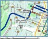
Goose Hollow Boundaries
North: West Burnside Street.
|
To learn more about the
|
Learn MoreAbout
|
Goose HollowTransit Map
Click to enlarge |

Pearl
Guide to the Pearl District Neighborhood in Portland, Oregon
 Located on the north edge of downtown, the Pearl District is now the liveliest area in Portland. Walk to work, eat out frequently, take walks along the river, and jump on a streetcar that loops the downtown areas of the city.
In the early 1900s, the Pearl District was a major industrial and transportation hub of Portland, with extensive rail yards, warehousing, and manufacturing facilities. In the 1950s, many industrial activities were relocated as transportation patterns shifted from water and rail to surface transit on interstate highways and air. The low rents that soon followed created spaces for artists and small businesses. In the 2000s it transitioned to one of the most desirable locations in the city. Renovations and adaptive use of historical and other structures have led to loft housing, row houses, condos, new restaurants, art and ceramic galleries, and a burst of new retail activity. A flurry of important new urban creative-commerce entrepreneurs, ranging from small internet firms to world-class advertising and multi-media companies, are staking out territory here.
All that's missing is a neighborhood elementary school and its coming. Six classrooms will open for the 2011 school year for K-2 students. Complete with a playground, the school will be housed in the six-story, 1380-unt apartment building being planned by developer Ed McNamara. The building will be bounded by NW 13th and 14th avenues between Quimby and Raleigh streets.
The Project for Public Spaces had this to say about the Pearl: "The Pearl is connected seamlessly to the upscale residential area known as Northwest Portland (NW 23rd and NW 21st), and also with the vibrant downtown area primarily because of the Portland Streetcar but also due to the pedestrian-friendly nature of the streets and neighborhood. There is no real center for the area; however, since the streetcar opened in 2001, it has centered on the area around NW 10th and 11th Avenues. The place is so accessible that many people have gotten rid of their cars or use them very rarely. The sidewalks are very inviting with storefronts lining them. The streets are narrow and include Portland's famous 200 foot grid block system."
History of the Pearl
I
 t wasn't very long ago that the old Burlington Northern rail yard in Northwest Portland was an area of abandoned warehouses, empty offices and an unused railroad track. Much has changed in the decade since. Today, this same area is now home to condos, apartment buildings, restaurants, shops, and offices.
To view the contrast between a few intervening years and in the same physical area, here are two photographs. You can see the "before" and "after" effect.
You will want to view the video by Hoyt Street Properties, the primary developer of the north end of the Pearl. Just click here to view the video.
Origin of the Name Pearl
The name "Pearl" reportedly came from Thomas Augustine, owner of the Augustine Gallery, who spoke of the precious gems hidden in the neighborhoods crusty old warehouses. Earlier the area was referred to as The Northwest Triangle.
Pearl Home Styles
The Pearl is solid condos and apartment buildings along with a handful of townhomes. You will see the term "loft" in the Pearl which legally means a condo. In the early to mid 90s, a number of warehouses were converted into lofts (large open spaces). Lofts became so popular in the Pearl that new loft-buildings were built when all the desirable warehouses had been converted to living units. Many traditional condos with multiple rooms were built in the 90s and 2000s. The Pearl does not have any detached single-family homes.
1Pearl District Home Prices
- Number of Homes Sold in the Pearl—► 280 condos were sold in 2012 and 11% were distressed sales. 235 condos were sold in 2011 and 20% were distressed sales. 140 condos were sold in 2010 and 13% were distressed sales.
- Median Price for Homes Sold in the Pearl—► $376,650 in 2012, $373,313 in 2011, $373,213 in 2010, $389,000 in 2009, $529,950 in 2008, and $440,000 in 2007.
- 1-Year Median Sales Price Change in the Pearl—► 2011 to 2012 the sales price change was 6%. 2010 to 2011 the sales price change was -9%. 2009 to 2010 the sales price change was -4%.
- 5-Year Median Sales Price Change in the Pearl—► 2008 to 2012 the sales price change was -33%. 2007 to 2011 the sales price change was -22%. 2006 to 2010 the sales price change was -7%.
- Portland Metro Area Median Home Price—► $235,000 in 2012, $221,000 in 2011, $239,900 in 2010, $247,000 in 2009, $278,000 in 2008, and $290,000 in 2007.
- Portland Metro Area Average Home Price—► $275,000 in 2012, $263,300 in 2011, $282,100 in 2010, $289,900 in 2009, $330,300 in 2008, and $342,000 in 2007.
Please be aware that the above figures are subject to error and are intended as guidelines only.
Homes for Sale in the Pearl District
Parks, Community Centers, and Health Clubs in the Pearl
Three existing neighborhood parks make living in the Pearl appealing. Two additional parks are planned for construction in the Pearl District. One is The Fields (see description below) and another is a potential park along the Willamette River.

- The Fields is planned for what is now an open field bordered by Northwest 11th Avenue, Overton Street and Naito Parkway. The Fields is the third of four parks in the Pearl District and will be connected by a footbridge to the Centennial Mills redevelopment along the Willamette River. The park will be about 150,000 square feet. Construction begin in March 2012.
- Jamison Square is a .94 acre park in which the focal point of the park is a fountain which simulates a shallow tidal pool. Water cascades from stone joints into low pools as the fountain continuously re-circulates treated water. It is a welcome relief on hot summer days and evenings. It was completed in 2002.
- Tanner Springs Park makes a connection to the past when Tanner Creek used to flowed openly through the Pearl; today it flows through large pipes beneath the city streets. The design of the park recapture the area's past with its native wetlands and flowing runnels. It is a place to sit and reflect. It was completed in 2005.
- North Park Blocks is six blocks (2.43 acres) long with mature Big Leaf Maples and Black Locusts along with a few American Elms. These blocks were some of the original park properties in the city which were dedicated in 1869. Drive down NW Park Avenue or NW 8th Avenue and it's hard to keep one's eyes on the road instead of looking at the 80-100 foot trees.
The Zimmerman Community Center (ZCC) is an urban nonprofit organization committed to strengthening the spiritual and civic life and identity of Portland's River District. Founded by a bequest from local schoolteacher Isobel Faith Zimmerman, the ZCC seeks to build community bonds that bring together people who live and work in in the Pearl and Old Town/Chinatown neighborhoods.
Two private health clubs are located in the Pearl:
- 24-Hour Fitness The Pearl club is located at 1210 NW Johnson Street.
- LA Fitness The club is located at 1414 NW Northrup Street.
There are also a number of boutique clubs that specialize in just one workout such as Pilates and Yoga.
The Pearl District has seven acres of park land and open spaces according to Metro and the Portland Department of Parks and Recreation.
Brewery Blocks and Lovejoy Blocks
 In 2000, another large-scale redevelopment project in the Pearl District began on the site of a former five-block brewery, called the Brewery Blocks. Gerding/Edlen Development Company bought the historic brew houses, which were converted into approximately 1.7 million square feet of retail and office space, and new residential buildings. Both the historic and new buildings are incorporating environmentally friendly techniques that will provide long-term savings as well as conserve energy. For instance, during the construction phase of the Brewery Blocks, a recycling program diverted 96 percent of construction waste from going to landfills.
The Lovejoy Blocks, bounded by Northwest Lovejoy and Marshall streets and Northwest 12th and 14th avenues, includes a nine-story grocery and office building and a 16-story retail and apartment building. In Block One, a Safeway store occupies the full block at ground level, and a partial second level houses back-of-store operations. Three levels of parking and three levels of office space top the store. Block Two includes retail space at the ground floor, parking on the ground through third floors and residential apartments on the fourth through 16th floors.
Pearl District Neighborhood Awards
Sierra Club In 2005, the Sierra Club named the Pearl District as one of America's best new development. The Sierra Club considered a wide range of projects, from cities large and small, to suburbs, to small towns in each corner of the nation. Here is a quote from the report: "In urban planning circles, Portland has emerged as a model city, at the forefront of creating a vibrant, quality urban environment, and the Pearl District only bolsters its reputation."
Money Magazine The October 2007 issue of Money Magazine named the Pearl District one of the best places to retire. Here is an excerpt from the article, "When Joyce Edwards visited friends in Portland a couple of years ago, she wasn't in the market for a new hometown. But she immediately realized that this Northwest city was the place for her." There aren't many places, she says, "That appeal to her interests in both culture and the great outdoors."
The Pearl and Pets
 Hannah is a yellow Lab, a citizen of the city. She rides the elevator with her owner. She goes between her 4th floor condo in the Pearl and the street-level merchants who greet her sweet demeanor with fellowship and a biscuit. Hannah is an emerging generation of condo dogs who, in order to live indoors, must be tested and certified as good citizens in terms of qualities. This good-citizen mandate stands in bylaws for condominiums built by Hoyt Street Properties, a Pearl developer and the nation's first condo builder to require the pledge. To view Pearl properties that allow pets visit Portland and Pets.
Pearl Web Sites
- Pearl District Photo Tour Take a photo tour of the neighborhood.
- Pearl District The Pearl District Neighborhood Association Web site.
- Shopping Guide It covers over 175 different restaurants, shops, etc. The site will guide you to the places with a map.
First Thursday in The Pearl
On First Thursday, art galleries are open for extended hours on the first Thursday, each month. Usually, the hours are from 6:00 pm to 9:00 pm. Most galleries offer free wine and visitors mingle with the artists. First Thursday gallery opening receptions are free and open to the public. Below is a video explaining the history of First Thursday along with a visit to the Lawrence Gallery.
Walking in the Pearl
The Pearl is pedestrian heaven! It's laid out on an easy grid of numbered streets running north to south and named streets are in alphabetical order and run east to west. The Portland Streetcar connects an area south of downtown called South Waterfront and the Nob Hill business district. You can ride free on the streetcar line in the area between downtown and Irving Street in the Pearl. Portland is the most bicycle friendly town in America and bike racks, bike lanes, and bike safety are in abundance in the Pearl.
Here are some walking tours in the downtown area of Portland:
- Public Art Walking Tour The Regional Arts & Culture Council (RACC) along with the Portland Oregon Visitors Association have a Public Art Walking Tour map/brochure – a colorful guide to nearly 100 public art pieces in downtown Portland and the near eastside. This free brochure is available at Portland-area visitor centers, or by calling RACC at (503) 823-5111. You can also download a copy by clicking here.
- Walking Tour to Pittock Mansion This 2.8-mile walk begins in Northwest Portland and climbs some of the city's longest staircases through Westover Heights. It ends at the Pittock Mansion, a restored French Renaissance Revival chateau. The home, its grounds, and fabulous views are open to the public. Click here to download the guide.
- Walking Tour Nob Hill and the Pearl District This 3.3-mile walk begins at PGE Park it takes you through historic neighborhoods to shops, galleries, restaurants, and theaters in the Pearl District and Nob Hill. Click here to download the guide.
- South Parks Tree Walk Portland State University students surveyed the South Park Blocks trees in 2004 and this data was used to appraise the value of the trees according to the Council of Landscape & Tree Appraisers Guide. They determined the trees in the park were worth more that $3.4 million. Click here to download the guide.
- The NW23rd/Pearl District Gallery & Walking Map The combined Northwest District (aka Alphabet District, Nob Hill, or NW23rd) and Pearl Gallery map provides key information for Portland First Thursday gallery walkers. Galleries, public art, restaurants, coffeehouses, pubs & bakeries are clearly labeled on the map and in the index. Parking, mass transit, and key landmarks are shown. If your time is limited, you can see at a glance what blocks have the greatest density of galleries, bakeries, or restaurants. Click here to download the map.
- The Pearl Gallery Map The map provides key information for Portland First Thursday gallery walkers. Galleries, public art, restaurants, coffeehouses, pubs & bakeries are clearly labeled on the map and in the index. Parking, mass transit, and key landmarks are shown. If your time is limited, you can see at a glance what blocks have the greatest density of galleries, or restaurants. Click here to download the map.
Walk Score helps you find a walkable place to live. Walk Score is a number between 0 and 100 that measures the walkability of any address. Portland is the 12th most walkable city in the U.S. with a Walk Score of 66 and 57% of the residents have a Walk Score of 70 or above. The Pearl District neighborhood ranks third out of 88 Portland neighborhoods so it is easy to get by without owning a vehicle. Below is the Walk Score for an address in the center of the Pearl.
More About the Pearl District
- Location North downtown neighborhood which means you are north of Burnside. Pearl streets are all labeled "NW . . ." Cross over the I-405 freeway and you're in the Nob Hill neighborhood.
- Neighborhood Association Web Site and Blog The Pearl District Neighborhood Association was founded in 1991. Visit the Pearl District blog.
- Pearl WiFi Hotspots To locate WiFi hotspots in the Pearl click here.
- 2Drive Time to Downtown Four minutes.
- Topography Flat and trees lining some streets. The Pearl is a urban/city grid layout.
- Sidewalks and Streets Streets are crowded with parked cars. Wide sidewalks for walking with friends and family.
- Livability Study 87.5% of Pearl District residents rated their neighborhood "good" or "very good." See Livability Study.
- Public Transportation Walking to the heart of downtown takes minutes. The Portland streetcar line connects the Pearl with the Northwest District, downtown, RiverPlace, South Waterfront and inner eastside. The MAX Light Rail line runs just a few blocks east of the Pearl in the Old Town/Chinatown neighborhood. TriMet also has 11 bus lines in the Pearl. Transit Score provides a 0-100 rating indicating how well an address is served by public transportation. Ratings range from "Rider's Paradises" to areas with limited or no nearby public transportation.
- 3Census 2010 Demographics Population: 5,997. Area size: 285 acres. Average population density 21 persons per acre. Number of households: 5,315. Average size of household: 1.13. Median household income: $45,857. Percent of home owners: 36%. Percent of renters: 64%. Diversity: 15% non-Caucasian. More census data about the Pearl District at Portland Online.
- 4Crime Stats There were 38 violent crimes and 16 crimes per 1,000 residents in 2012. There were 29 violent crimes in 2011 and crimes per 1,000 people was 16. For the latest crime statistics for the Pearl neighborhood, click here.
- Sex Offenders Click here for the State of Oregon Sex Offender Inquiry System. After agreeing to the "Conditions of Use Statement" you will be redirected to a "Enter Search Criteria" page. Insert a zip code in the "Zip" field and click on the "Query" button. Pearl District zip code: 97209.
- 5Shopping and Services Number of supermarkets: 2. Number of health clubs: 5. Number of coffee shops: 10. Two markets, Whole Foods on the south side of the neighborhood and Safeway on the north side make for convenient food shopping in the Pearl. The Pearl Bakery and Holden's (deli) are also good bets for quality food items. If you want a piece of art, galleries are numerous as well as many home boutiques. You can find just about everything you need in the Pearl to outfit your new condo. Powell's City of Books, the largest independent book store in the USA, features a city block's worth (68,000 square feet) of new and used books.
- Farmers Market The Wednesday market is held between Southwest Salmon and Main streets. 10 am-2 pm Wednesdays, May-October. The Saturday market is held at the South Park Blocks by PSU between Southwest Harrison and Montgomery streets. 8:30 am-2 pm Saturdays, March-December. The Northwest District/Nob Hill farmer is between Northwest 23rd Avenue and Savier Street, 3 pm-7 pm Thursdays, June-September. Pioneer Courthouse Square is held 10:00 am-2:00 pm on Mondays from June-December. More information at Portland Farmers Market.
- Eating Out Every type of ethnic food is now available in the Pearl to include Pacific Northwest cuisine. The Pearl has numerous coffee shops and a couple of places serve a hearty breakfast and a "workingman" lunch. Top choices for Pearl restaurants include Andina, Bluehour, Caffe Allora, Daily Cafe, Fenouil, Le Bouchon, Olea, Park Kitchen, and Sungari Pearl. TheUrban Spoon lists Pearl restaurants with short reviews from local publications.
- Public Library Hop on the streetcar and head on over to the to the Multnomah County Central Library in downtown Portland or to the Northwest District branch located at 2300 NW Thurman Street.
- What They Drive in the Pearl District You see lots of Hondas and Toyotas - also a few BMWs and Audis. Limited number of SUVs. Car ownership is limited due to parking. If a Pearl District resident needs a car, they can rent one or use Zipcar.
- 6Biking Quality is high. The Pearl has five miles of bike lanes.
- Schools Elementary school: Chapman. Middle school: East-West Sylvan. High school: Lincoln High School. Emerson Charter School, located in the North Park Blocks, has a long waiting list of students to enter. Emerson serves grades K-5.
- 7School Report Card Grades Elementary school: O/S. Middle school: O. High schools: O/I. Click here for report card details.
Map of the Pearl Neighborhood
Fly to the Pearl Neighborhood via Google Earth
Coordinates
45° 31′ 31.25″ N
122° 41′ 50.69″ W
Launch Google Earth
_____________________________________
1Real Estate Values Data on real estate values provided by RMLStm. Distressed properties refer to the percentage of total homes sold that were short sales and bank-owned properties.
2Drive Time to Downtown Estimated commuting time obtained from Yahoo Maps and Google Maps. Drive time was calculated from a central intersection in each neighborhood to Pioneer Courthouse Square during the morning peak commute time.
3Demographics Data Numbers were obtained from Census 2010 and www.portlandmaps.com.
4Crime Statistics Numbers on crime were obtained from Portland Police Bureau. Violent crimes are defined as murder, rape, robbery, and aggravated assault. Crimes per 1,000 are based on reported incidents of violent crime, as well as burglary, larceny, and motor vehicle theft.
5Shopping and Services Numbers were determined from local directory listings and county/municipal library systems.
6Biking Quality rating based on the 2007 Cycle Zone Analysis conducted by the City of Portland Office of Transportation. The six-tier ratings have been reduced to three levels: High, Fair, and Low.
7School Report Card Grades Schools ratings from the Oregon Department of Education 2009-2010 performance assessment. "O" = Outstanding; "S" = Satisfactory; "I" = In Need of Improvement; NR = Not Rated.
View
|
Pearl District Boundaries
NW Broadway Avenue on the east, West Burnside Street on the south, the I-405 Freeway on the west and the Willamette River on the north. The neighborhood encompasses the North Park Blocks, the 13th Avenue Historic District, the city's Main Post Office.
Map Showing Pearl District Boundaries
|
To learn more about the
|
Learn More
|
Walking Map
|
Nob Hill / Northwest
Guide to the Northwest District Neighborhood in Portland, Oregon
Also Known as Nob Hill

Some of the locals call it "Trendy-third Avenue." But most Portlanders simply call the area "Northwest." Another name commonly used for the area is Nob Hill after the San Francisco area. Portland trendiest shopping is on ten blocks of Northwest 23rd Avenue between Burnside and NW Northrup streets.
'Twenty-third' is the place to go if you want to walk and people-watch and browse through shops. NW 21st Avenue is edgier. Wooden utility poles there have held so many concert posters that the rusty staples may be all that hold them up.
This is the neighborhood Bill Walton lived when he played for the Blazers in the 70s. He was the star when the Blazers won the NBA championship in 1976-77. Bill was (and still is) a popular guy in Portland.
The Northwest Examiner reported (June 2010 issue) that in the spring of 2010, famed urban planner/architect Andres Duany visited Portland in May and fell in love with Northwest 21st Avenue. He called it the “glory of Portland” and the 21st and Johnson crossing, in particular, the “quintessential Portland intersection.” Duany, a leader in the international New Urbanism movement, was in town for several speaking engagements, and his comments on 21st Avenue were part of a lecture at Metro headquarters. Duany praised the blending of “great old commercial buildings” and multi-story apartment structures on the avenue, resulting in a self sustaining level of density, manageable parking demands, affordable retail rents and a compatible mixture of uses. It's worth visiting the intersection (NW 21st and NW Johnson) to view the type of buildings.
The citizens of Portland love their pets (Portland rank first in the country with 5.8 dog parks per 100,000 residents) and Dove Lewis Emergency Animal Hospital is an important part of the Nob Hill neighborhood. Dove Lewis specializes in the emergency and critical care of pets. According to their Web site, they are open "24 hours a day, 365 days a year to provide proficient, compassionate care."
You can download a map of the Northwest District − it also includes Washington Park.
History of Nob Hill
The area's history begins in the 1840s when Captain John H. Couch (pronounced Coo-ch) decided that Portland should be Oregon's largest city instead of Oregon City, which was the main settlement at the time. A sailor, he came to believe that Oregon City, further downstream, presented too many navigation problems. So the Captain in 1845 speculated on a land claim in what is now part of the Pearl and Northwest District. Couch made his fortune sailing ships with supplies between Portland and San Francisco during the gold rush era as the miners were on a spending spree. Three of his daughters built homes along NW 19th Avenue and that became the core of Nob Hill. Couch subdivided his land and investors build luxury rental apartments as well as large homes.
When Portland's grown exploded following the 1905 Lewis and Clark Exposition, the neighborhood began to add more multifamily housing units. During WWII, with thousands working in the Kaiser shipyards, Nob Hill was densely occupied as many homes were divided into rental units. After the war, residents took to their new automobiles and fled to the suburbs. The area became depressed until the city underwent a revival in the 70s thanks in large part to higher gas prices as the suburbs began to lose their appeal. The area became attractive to investors, preservationists, and young people. Many of the vacant commercial buildings along NW 21st and 23rd began to attract businesses and now these buildings are occupied by restaurants, national chains, and boutiques. You know the area is thriving when it takes ten minutes to find a parking spot.
Origin of the Names Northwest and Nob Hill
"Northwest" came about because of common usage whereas "Nob Hill" most likely was adapted from "Nob Hill" in San Francisco. The San Francisco Chronicle defines Nob Hill and Russian Hill area as within Bay Street, Van Ness Avenue, Taylor Street, and Pine Street.
Alphabet Historic District
 Hats off to Douglas Taylor, superintendent of streets when Portland, East Portland, and Albina consolidated in 1891. Because of the street name duplication between the three areas, Mayor W.S. Mason referred the matter to the City Council "Streets Committee" which passed the problem off to Superintendent Taylor. Taylor and his staff recommended to the "Streets Committee" a street naming pattern in the Couch subdivision (Northwest District and Pearl District) that is easy to remember; numbers in one direction and letters in alphabetical sequence in the other. Thus we have going from south to north: Burnside (the street that divides southwest from northwest as well as northeast from southeast), Couch, Davis, Everett, Flanders, Glisan, Hoyt, Irving, Johnson, and so forth. Some of the street names (Couch to Irving) continue across the river into Northeast Portland. The numbers are also in sequence of course. Taylor must have been a pretty good politician − he gave the "Streets Committee" a list of alternative names for most streets and he let them pick and choose.
The "Alphabet Street" is a Historic District and listed on the National Register of Historic Places. The area is roughly bounded by NW Lovejoy Street, NW Marshall Street, NW 17th Avenue, W. Burnside Street, and NW 24th Avenue.
Nob Hill Home Styles
You will find a variety of housing in Northwest. Everything from classic brick apartment houses, new condos, apartments that have been converted to condos, new townhomes, plexes, and detached single family homes. Prices range from the low 100s to well over a million. There is something for practically everyone's billfold. You will find apartments on every block with over 75-80 percent of the residents residing in an apartment. This area is changing rapidly as developers buy a couple of older homes, remove them, and build 6-8 new townhomes. Or they buy a run-down commercial building, demolish it, and erect a new condominium in its place.
The 1,569 acre Alphabet Historic District (also known as Portland West End Historic District) is roughly bounded by NW Lovejoy Street, NW Marshall Street, NW 17th Avenue, W. Burnside Street, and NW 24th Avenue. The National Register of Historic Places has identified 478 buildings in the Alphabet Historic District. Homes styles include Bungalow/Craftsman and Queen Anne.
1Northwest District Home Prices
- Number of Homes Sold in Northwest District—► 155 homes were sold in 2012 and 17 percent were distressed sales. 156 homes were sold in 2011 and 13 percent were distressed sales. 146 homes were sold in 2010 and over 100 of these were condos and townhomes — distressed properties sales were 16%.
- Median Price for Homes Sold in Northwest District—► $390,000 in 2012, $339,000 in 2011, $340,000 in 2010, $317,500 in 2009, $325,000 in 2008, and $289,950 in 2007.
- 1-Year Median Sales Price Change in Northwest District—► 2011 to 2012 the price change was 15%. 2010 to 2011 the price change was 9%. 2009 to 2010 the price change was -5%.
- 5-Year Median Sales Price Change in Northwest District—► 2008 to 2012 the price change was 20%. 2007 to 2011 the price change was 9%. 2006 to 2010 the price change was -6%.
- Portland Metro Area Median Home Price—► $235,000 in 2012, $221,000 in 2011, $239,900 in 2010, $247,000 in 2009, $278,000 in 2008, and $290,000 in 2007.
- Portland Metro Area Average Home Prices—► $275,000 in 2012, $263,300 in 2011, $282,100 in 2010, $289,900 in 2009, $330,300 in 2008, and $342,000 in 2007.
Please be aware that the above figures are subject to error and are intended as guidelines only.
Homes for Sale in the Northwest District
- View Nob Hill homes currently for sale by clicking here
- View recent home sales in Nob Hill by clicking here
Parks and Community Centers in the Neighborhood
Northwest District residents have two parks within their borders and easy access to the 5,000 plus acre Forest Park.
- Wallace Park (5.39 acres) is located at NW 25th Avenue and NW Raleigh Street adjacent to the Chapman Elementary School. Facilities include a basketball court, dog off-leash area, horseshoe pit, picnic site, playground, soccer field, softball field, tennis court and restrooms.
- Couch Park (2.39 acres) at NW 19th Avenue and NW Glisan Street includes an outdoor basketball court, restroom, dog off-leash area, and playground.
The Friendly House is located at NW 26th Avenue and NW Savier and it is truly a community asset. Founded in 1930, the "neighbor helping neighbor" philosophy is at the heart of Friendly House and its programs. It has programs for children, adults, and seniors. Although small in size, it does have a room full of exercise equipment along with a gym that is used constantly.
The Northwest District has 15 acres of park land and open spaces according to Metro and the Portland Department of Parks and Recreation.
Northwest 21st & 23rd Shopping and Dining
 A popular commercial area exists on Northwest 23rd Street (and to a lesser extend on 21st Street) running 10-12 blocks. Some of the Portland's best dining spots are located along these two streets. 23rd is a browsers paradise with numerous shops ranging from clothing boutiques to book stores. West Burnside is solid businesses from auto dealerships (Volvo and Jag) to mini-malls.
Portland's new streetcar line that began in July 2001, connects the Northwest District with downtown and South Waterfront. Its route is circulator − a transit service that moves people through the Central City.
Northwest is an Entertainment Center! This is where the "characters" hang out because they come to the Fred Meyer Stadium branch supermarket (the locals called it Freddy's) and unload their soda cans and bottles (Oregon Bottle Bill) and collect their money. Some then shop at Freddy's. I once asked a check-out person at the stadium branch if she ever got bored working at Freddy's. "Yes," she replied, "when I worked at a Fred Meyer store in the suburbs."
PlayDate PDX created a 7,500 square foot indoor play place at 1434 NW 17th Avenue that is tailored to create a safe and energetic environment that stimulates the imagination and gives your children space to roam at the same time giving parents a comfortable and soothing environment to relax and enjoy a warm cup of Stumptown coffee. With help from their landlord and International Play Co., which designs and builds play structures, two ER doctors transformed a light-industrial space on the border of the Pearl and Northwest districts. Now the building is a Land of Make Believe-themed playground, with passageways and slides snaking through a pretend castle. On one side, kids and an adult or two engage in a squishy-ball shootout on the air-cannon range. In another corner, a light-up dance floor flashes. The play area covers a third of the 7,500-square-foot floor space, not counting its second and third levels. Filling much of the rest are a central seating area and several party rooms for rent.
Click here to access a shopping guide to Nob Hill.
Slabtown
 This area of the Northwest District — historically known as Slabtown, more recently dubbed NoLo (north of Lovejoy) by real estate agents — is an area of approximately 50 square blocks. In the 1880s, the poor, working-class residents in part of Northwest Portland used slabs of cheap wood from sawmills as fuel for their fireplaces. Slabtown became a semi-derogatory term for the area by the rich, who could afford cordwood that was cut to size.
St. Patrick’s Church, 1623 NW 19th Avenue, was in the middle of the poor neighborhood, while the wealthy lived closer to West Burnside Street, around 15th and 16th Avenues. So says Richard Engeman, staff historian at the Oregon Historical Society. Today, the prominent 'Slabtown' sign at the corner of Northwest Lovejoy Street and 15th Avenue, a relic from the 1970s, is one of the only reminders of the term. The sign was the inspiration for the bar and music lounge of the same name, Slabtown, located at 1033 NW 16th Avenue and is famously known as the birthplace of the Portland band the Dandy Warhols.
Slabtown is labeled the “transition area” in city documents. It is changing, adding dozens of town houses and condominiums. Town houses and condos are replacing old industrial plants. A 25-town house development opened in May 2006 on NW 20th Avenue and Pettygrove Street, with units priced around $500,000. The historic Lane-Miles Standish building, for 85 years home to a printing business at NW 19th Avenue and Raleigh Street, has been converted to a mix of office space and five levels of residences.
Vaux Swifts at Chapman School
 In early September you can sit on the lawn at Chapman School and watch the spectacular aerial display of thousands of Vaux's Swifts as they gather and spiral into the school's chimney to roost. The swifts begin gathering in the sky above the Chapman School neighborhood in large numbers 40 to 60 minutes before sunset. Closer to sunset the swifts begin circling directly above the school chimney in a large flock − this is a dramatic sight and ideally you will be there before it begins. They begin to enter the chimney within 10 to 30 minutes after sunset. Portland Audubon volunteers are always on hand nightly to answer questions and offer views through spotting scopes.
Video Tour of Nob Hill
Walking in the Northwest District
Here are some walking tours in the downtown area of Portland:
- Public Art Walking Tour The Regional Arts & Culture Council (RACC) along with the Portland Oregon Visitors Association have a Public Art Walking Tour map/brochure – a colorful guide to nearly 100 public art pieces in downtown Portland and the near eastside. This free brochure is available at Portland-area visitor centers, or by calling RACC at (503) 823-5111. You can also download a copy by clicking here.
- Walking Tour to Pittock Mansion This 2.8-mile walk begins in Northwest Portland and climbs some of the city's longest staircases through Westover Heights. It ends at the Pittock Mansion, a restored French Renaissance Revival chateau. The home, its grounds, and fabulous views are open to the public. Click here to download the guide.
- Walking Tour Nob Hill and the Pearl District This 3.3-mile walk begins at PGE Park it takes you through historic neighborhoods to shops, galleries, restaurants, and theaters in the Pearl District and Nob Hill. Click here to download the guide.
- The NW23rd/Pearl District Gallery & Walking Map The combined Northwest District (aka Alphabet District, Nob Hill, or NW23rd) and Pearl Gallery map provides key information for Portland First Thursday gallery walkers. Galleries, public art, restaurants, coffeehouses, pubs & bakeries are clearly labeled on the map and in the index. Parking, mass transit, and key landmarks are shown. If your time is limited, you can see at a glance what blocks have the greatest density of galleries, bakeries, or restaurants. Click here to download the map.
Walk Score helps you find a walkable place to live. Walk Score is a number between 0 and 100 that measures the walkability of any address. Portland is the 12th most walkable city in the U.S. with a Walk Score of 66 and 57% of the residents have a Walk Score of 70 or above. The Northwest District neighborhood ranks fifth out of 88 Portland neighborhoods. Below is a Walk Score for an address in the center of the neighborhood.
More About Northwest District
- Location West of downtown. When you cross I-405, you are in the Northwest District. The streets are all "NW . . ." and if they say "SW . . .", you are in the Goose Hollow neighborhood.
- Neighborhood Association Web Site Northwest District Neighborhood Association.
- Neighborhood Weblog Northwest District Weblog.
- Northwest District WiFi Hotspots To locate WiFi hotspots in the Northwest District click here.
- Neighborhood News The Northwest Examiner is a free monthly publication that covers the community. You can download the the current issue as well as past issues The Neighborhood Activist is a two to three page monthly print newsletter produced by Neighbors West-Northwest and you can download the latest issue.
- 2Drive Time to Downtown Four minutes.
- Topography Mature trees in yards and parks. Hilly with winding roads along on the west border of the neighborhood bordering Forest Park.
- Sidewalks and Streets There are many cars in this neighborhood so streets are full of cars, especially east of NW 25th. Sidewalks everywhere in the neighborhood and wide enough for two people to walk together.
- Livability Study 90.3% of Northwest District residents rated their neighborhood "good" or "very good." See Livability Study.
- Public Transportation TriMet has seven bus routes in Northwest. The streetcar line travels to the neighborhood from the Pearl District via NW Northrup Street, goes a couple blocks up NW 23rd Avenue and heads back east on NW Lovejoy Street. Ride downtown to Portland State University or on to the South Waterfront or cross the river and visit OMSI. Transit Score provides a 0-100 rating indicating how well an address is served by public transportation. Ratings range from "Rider's Paradises" to areas with limited or no nearby public transportation.
- 3Census 2010 Demographics Population: 13,390. Area size: 976 acres. Average population density: 13 persons per acre. Number of households: 9,420. Average size of household: 1.42 persons. Median household income: $52,100. Percent of home owners: 24%. Percent of renters: 76%. Diversity: 12.6% non-Caucasian. More census data about the Northwest District at Portland Online.
- 4Crime Stats 50 violent crimes and crimes per 1,000 residents was eight in 2012. 35 violent crimes and eight crimes per 1,000 residents in 2011. For the latest crime statistics for the Nob Hill neighborhood, click here.
- Sex Offenders Click here for the State of Oregon Sex Offender Inquiry System. After agreeing to the "Conditions of Use Statement" you will be redirected to a "Enter Search Criteria" page. Insert a zip code in the "Zip" field and click on the "Query" button. Northwest District zip code(s): 97209, 97210.
-
5Shopping and Services Number of supermarkets/food stores: 4. Number of health clubs: 3. Number of coffee shops: 16.
The Northwest District has a large supermarket (Fred Meyer) along with numerous specialty shops. Besides the large food markets such as Zupan's and Fred Meyers, Northwest residents have access to Trader Joe's on NW Glisan Street, City Market on NW 21st Avenue, Food Front Coop on NW Thurman and 24th, and Elephant's Delicatessen just off West Burnside. It also has a couple of bakeries along with a meat market. - Farmers Markets The Wednesday market is held between Southwest Salmon and Main streets. 10 am-2 pm Wednesdays, May-October. The Saturday market is held at the South Park Blocks by PSU between Southwest Harrison and Montgomery streets. 8:30 am-2 pm Saturdays, March-December. The Northwest District/Nob Hill farmer is between Northwest 23rd Avenue and Savier Street, 3 pm-7 pm Thursdays, June-September. Pioneer Courthouse Square (downtown) is held 10:00 am-2:00 pm on Mondays from June-December. More information at Portland Farmers Market.
- Eating Out Restaurants cover the complete range from "Gourmet Magazine Top 100" to shops serving a slice of pizza. These make everyone's list of best restaurants in the Northwest District: Balvo, Bewon, Cafe Mino, Carlyle, Ken's Artisan Bakery, Paley's Place, and Wildwood. Urban Spoon rates over 100 restaurants, coffee places, and sandwich shops in the neighborhood.
- Public Library A branch of the Multnomah County Library system is located on 2300 NW Thurman Street.
- Who Lives in the Northwest District Young singles who want to be close to the action. People of all ages live in the Northwest but children are not very evident in the neighborhood. The median age is 34.
- What They Drive in Nob Hill Hondas, Nissans, and Toyotas. Limited number of SUVs. Because of the large number of apartments and restaurants, parking is a problem no matter what kind of car you own.
- 6Biking The quality if high/fair. The Northwest District has 15 miles of bike lanes.
- Schools Elementary school: Chapman. Middle school: East-West Sylvan. High school: Lincoln High School and Metropolitan Learning Center.
- 7School Report Card Grades Elementary school: O. Middle schools: O/S. High schools: O/S. Click here for report card details.
Map of the Nob Hill Neighborhood
Fly to the Northwest District via Google Earth
Coordinates
45° 32′ 02.84″ N
122° 41′ 40.67″ W
Launch Google Earth
_____________________________________________
1 Real Estate Values Data on real estate values provided by RMLStm. Distressed properties refer to the percentage of total homes sold that were short sales and bank-owned properties.
2 Drive Time to Downtown Estimated commuting time obtained from Yahoo Maps and Google Maps. Drive time was calculated from a central intersection in each neighborhood to Pioneer Courthouse Square during the morning peak commute time.
3Demographics Data Numbers were obtained from Census 2010 and www.portlandmaps.com.
4Crime Statistics Numbers on crime were obtained from Portland Police Bureau. Violent crimes are defined as murder, rape, robbery, and aggravated assault. Crimes per 1,000 are based on reported incidents of violent crime, as well as burglary, larceny, and motor vehicle theft.
5Shopping and Services Numbers were determined from local directory listings and county/municipal library systems.
6Biking Quality rating based on the 2007 Cycle Zone Analysis conducted by the City of Portland Office of Transportation. The six-tier ratings have been reduced to three levels: High, Fair, and Low.
7School Report Card Grades Schools ratings from the Oregon Department of Education 2009-2010 performance assessment. "O" = Outstanding; "S" = Satisfactory; "I" = In Need of Improvement; NR = Not Rated.
View
|
Northwest District Boundaries
West Burnside on the South side and the I-405 freeway to the East. North: Northwest District extends to NW Front Avenue, NW Nicolai Street and St. Helens Road. West: defined by the east boundaries of Forest and Macleay Parks, and a line running 600 feet west and parallel to Cornell and Westover Roads.
Map Showing Northwest District Boundaries |
|
Map of
|


Guide to the South Waterfront Neighborhood in Portland, Oregon
The South Waterfront, (SoWa as it is commonly called) the largest and most expensive redevelopment effort in Portland history, is transforming an abandoned industrial site along the Willamette River south of downtown into a high-rise neighborhood as dense as parts of Manhattan. Eventually, some 20 high-rise buildings will be built on the site. This includes medical offices and labs for Oregon Health & Science University (OHSU).
The Portland Development Commission (PDC) signed an agreement with OHSU and a group of waterfront property owners that cleared the way for construction of a 30 plus acre central district, which includes 3,000 residential units, one million square feet of office space, 150,000 square feet of retail and a hotel/conference center. If you desire to follow the progress of the development: South Waterfront. SoWa is not an official City of Portland neighborhood.
 South Waterfront area has become the first urban neighborhood in the United States to achieve Salmon-Safe certification. Salmon-Safe’s certification of South Waterfront means that the area exceeds state and federal regulatory commitments to protect the Willamette River and its urban tributaries. Salmon-Safe is a Portland based nonprofit certification organization. The designation commits the neighborhood to sustain its environmental stewardship over time, including the district-wide elimination of pesticides that are harmful to salmon and other aquatic life.
In addition to South Waterfront, other Portland Salmon-Safe certified urban projects are the Oregon Museum of Science and Industry, Nike, Portland State University, Portland Parks, Oregon Convention Center and Toyota at the Port of Portland. Salmon-Safe’s inspection team has certified more than 65,000 acres of farm and urban lands in Oregon and Washington, including 140 vineyards that represent a third of Oregon’s total vineyard acreage.
The SW Moody Project will reconstruct approximately 3,200 linear feet of SW Moody Avenue between SW River Parkway and SW Gibbs Street near the OHSU Tram. This project supports redevelopment of the 120-acre South Waterfront area which is part of Portland’s “Innovation Quadrant” slated to facilitate new job creation and provide access for people and goods. As the main access point to the South Waterfront Innovation Quadrant, SW Moody Avenue will be improved to include three traffic lanes, dual streetcar tracks, and pedestrian and bicycle facilities. The new construction will increase roadway capacity and introduce urban development standards such as fiber optic, sewer, stormwater and water infrastructure to support future development. This investment in roadway and streetcar facilities supports the Portland-Milwaukie Light Rail extension, “Close the Loop” streetcar line extensions, and the Portland to Lake Oswego streetcar line. Construction started in early 2011.
Blogs and Newsletter The Sowa Notes blog was originally started by Pearlgirl as a blog about the Pearl District, but she changed the scope of the blog to include other neighborhoods that she frequents. Visit the Sowa blog at http://www.sowa.neighborhoodnotes.com. The E-Current aims to keep you up to date and provide you with useful information about what's going on in the South Waterfront neighborhood, including calendar, maps, and other info. Click This email address is being protected from spambots. You need JavaScript enabled to view it. to subscribe.
You can view a map of the area (Adobe PDF format). Note that SoWa is part of the South Portland neighborhood association but it has a character of its own so we included a separate profile for the neighborhood.
OHSU Center for Health and Healing
 The first building, named The Center for Health & Healing (CHH), is a $150 million 16-story facility that was occupied in late 2006. The first two floors contain the March Wellness - a fitness center and health club. Four floors provide state-of-the art research space where OHSU scientists can create new knowledge and eight floors of the Center provide all types of patient care.
As riders of Portland's aerial tram descend Marquam Hill, the first feature they encounter in the new South Waterfront District is a two-story giant picture window looking in on basketball and volleyball courts at OHSU's new river campus. This is where you can discover, explore and realize your goals for a hearty and healthy life. Features of March Wellness include a lap pool, health coaching, aerobics, foreign language conversation groups, a gymnasium, meditation, financial health seminars, strength training, yoga, and healthy cooking classes.
The 50,000-square-foot center is open to OHSU's patients, students and faculty, but also to the public at rates competitive with the city's other major health clubs. The center is destined to become an important lure for the district's so-called "urban pioneers" - South Waterfront's first residents.
Collaborative Life Sciences Building Under Construction at South Waterfront
In October 2011, three of Oregon’s universities broke ground on a unique project that will combine the resources of these institutions. The OUS/OHSU Collaborative Life Sciences Building will place portions of Oregon Health & Science University, Oregon State University, and Portland State University under one roof. In doing so, the facility will extend partnerships between the universities, create new employment opportunities, and expand the schools’ teaching facilities, class sizes and research activities. The location of the building is between the Marquam Bridge and the Ross Island Bridge.
The 480,000-square-foot building will include lecture halls, classrooms, labs, specialty research centers, offices and a state-of-the-art facility for the OHSU School of Dentistry. The Collaborative Life Sciences Building will foster collaboration in undergraduate and graduate education between students and instructors from multiple institutions.
The Condos: Meriwether, John Ross and Atwater Place
 In early 2006, the first buildings appeared along Portland's South Waterfront. Developers and city planners hope they won't entirely block the Mount Hood and river views for residents and passers-by on the west side of I-5.
It's a seemingly contradictory goal to build taller buildings yet make them less visible on the skyline. The concept used by planners, architects and activists is "permeability". This means the ability to see through the development, even if only intermittently. Permeability doesn't just mean protecting the view from a single lookout, it's about trying to avoid uniform rows or "canyons" of buildings, instead allowing sunlight, wind and a variety of view angles between towers. The permeability is trying to get at thinner buildings, buildings that aren't occupying an entire block. The issue of permeability focuses on ways to build with the same amount of square footage, but with a thinner profile.
These are the first condos buildings.
- Meriwether Towers The two Meriwether towers (245-units in double tower stretching 21 and 23 stories tall. The towers were occupied by the first South Waterfront residents in 2006.
- The John Ross The John Ross is the first to reach a 325-foot height maximum allowed in the South Waterfront area. The building was occupied in the summer of 2007.
- Atwater Place In Block 34, a 22-story, rectangular tower will feature 212 condominium units, five of which would be townhomes. The Atwater Place was completed in late 2007.
Another condo building called 3720 began construction in the spring of 2007 and the developers decide to convert it to an apartment building (The Adrea) when the condo market went sour before marketing the units. It consists of a 30-story tower and a five-story "side-car" structure, which together contain 323 units, for a total of 350,000 square feet of condominium space.
Mirabella: Continuing Care Retirement Community
OHSU and Medford-based Pacific Retirement Services (PRS) launched a partnership in January, 2007, to build a senior living community called the Mirabella that will put hundreds of prospective residents at its South Waterfront doorstep. PRS is building a 30-story senior living community that would offer a range of retirement living options, from apartments to nursing home level care. The arrangement will strengthen OHSU's relationship with Intel, OHSU officials said, as the two can work to develop devices and techniques aimed at making aging easier. The project was designed for LEED Platium certification. Residents started moving in in the fall of 2010.
Apartments
 Apartment buildings in South Waterfront:
- Riva on the Park Atlanta-based real estate giant Trammell Crow Residential started work in the early Summer of 2007 on the first apartments in the South Waterfront area. This 22-story building is designed with a brick tower at the NW corner and a window-wall exterior that opens to the river views. The completed project has 314 apartments and three levels of structured parking. Riva on the Park includes a 28,000 square foot eco roof; a storm water sculpture; and a make-up air system to increase indoor air quality. The project achieve LEED Gold certification. At 22 stories, the 230-foot tower is the tallest apartment building built in Portland in about 40 years. It is slightly shorter than the twin Meriwether condo towers a block away. The building offers studios, one and two bedrooms, and penthouses.
- The Ardea The Ardea is a 30-story building that offers 323 apartment homes and 33 townhomes. It started out as the 3270 Condos but when the market for condos went sour, it was converted to apartments.
- Matisse The building consists of two five-story apartment buildings at Southwest Lowell Street and Moody Avenue. The Matisse's 272 rental units are the first of 700 market-rated apartments called for in the Portland Development Commission's South Waterfront urban Central District Development agreement. It opened in 2010.
- Gray's Landing was completed in late 2012. Gray’s Landing (previously known as “Block 49”) contains 209 housing units. Apartments are affordable to households earning 60% of Median Family Income ($30,660 for a single-person household). Forty two (42) of the apartments are targeted to low income veterans who have been homeless within the past two years. Cost of the building was $50.5 million.
Zidell Yards: 33-Acre Mixed-Use Community to be Developed
 At one time, the South Waterfront was filled with heavy industrial companies helping the shipping industry. One of the last remaining is The Zidell Company. After 80 years of supporting the shipping trades, the company is taking some of it's property and redeveloping it. They announced this undertaking in the fall of 2012.
Zidell Yards will be a 33-acre mixed-use community consisting of 27 buildings, apartments, retail and corporation headquarters built over the next 10 to 15 years. The ground is being readied for construction of an 18-unit apartment building. It will be named the Emery in honor of Emery Zidell, the company's second generation head.According to the Zidell Yards Website, "The river is a universal draw and the Zidell family believes it should be celebrated and shared as a citywide gathering place. Small, creative firms to large corporate campus users are demanding buildings with character and soul, collaborative open space floor plans, and sustainable features. Buildings at the Yards, as well as the natural and urban environments that surround them, will resonate with the forward-thinking companies that share these values."
Parks and Health Clubs in the Neighborhood
 The initial greenway parks master plan calls for $25 million in improvements to the Willamette Greenway. South Waterfront's greenway (along the river) is eventually supposed to run from the Marquam Bridge south to just beyond the Old Spaghetti Factory. The first phase will run from Gibbs Street to Lane Street and parallel to the area's first condo towers and includes trails and habitat view areas. The master plan for the first phase includes a pier and a kayak boat launch.
Elizabeth Caruthers Park is a 2.14 acre park that features an open lawn area for performances, an urban garden, boardwalks, a water feature, bike racks, public art and streetscape improvements. There is also a naturalized landscape with a storm water retention system. The park is named for Elizabeth Caruthers, one of the early settlers of Southwest Portland in the 1850s.
A cobblestone path to the river was completed when they constructed the Meriwether townhomes and it opens to an asphalt pathway along the river which is about 300 yards long. Connecting the path to the Gov. Tom McCall Waterfront Park to the north will not be easy as the path will have to cross over the Zidell Marine (shipbuilder) land plus other industrial land to the north of the marine. Connecting the trail to the Willamette Park to the south and to Gov. Tom McCall Waterfront Park in the north would mean bikers, runners, and walkers could travel about 4-5 miles along the west side of the Willamette River. The pathway would start at the Steel Bridge to the north and go all the way to the Sellwood Bridge to the south. Hopefully the planners have this in mind.
South Waterfront residents are able to have great views of the river if they face east. Looking across the river, strollers can view Ross Island, a refuge for wildlife and home to blue herons and bald eagles. The river also offers excellent canoeing and kayaking. Learn more at the River Renaissance Web site.
There are two health clubs in the neighborhood:
- March Wellness occupies the first two floors of the CHH building and it is open to both OHSU staff and the public. Besides the normal physical activities, March wellness offers foreign languages classes, nutrition cooking classes, etc.
- The RiverPlace Athletic Club is located about a half mile north of SoWa.
South Waterfront has a 2.12 acre park named after Elizabeth Caruthers, an early pioneer woman who was one of the first settlers in the southern part of the young city of Portland.
Aerial Tram Links OHSU Campuses
 Linking OHSU's Marquam Hill Campus to its first building in the river blocks, the Portland's Aerial Tram transports researchers, students, medical professionals, patients and visitors between Portland's foremost medical institution and its newest development. The 3,300-foot tram extends from the main Marquam Hill campus to a terminus at Southwest Gibbs Street and Moody Avenue near the Willamette River. The Portland Aerial Transportation (PATI) is the private non-profit organization empowered by the City of Portland to oversee the design, construction, and operation of the Portland Aerial Tram.
On December 15, 2006, the Portland Aerial Tram began ferrying Oregon Health & Science University employees. To catch a free ride on one of the nickel-colored pods requires an OHSU employee badge.
Tram Fares Officials from the city of Portland and OHSU approved the fare of $4 in late January, 2007, for non OHSU staff and patients. The $4 fare is for a round trip. OHSU staff and patients can ride free. As a courtesy, OHSU is paying the cost of the tram ride for its patients who have appointments at OHSU, and also for individuals who are visiting patients in OHSU Hospital or Doernbecher Children's Hospital. The city projects 85 percent of the tram's 1,540 daily riders will be OHSU-related. Other points:
- Offer free rides for annual and monthly TriMet and streetcar pass holders.
- Offer a $4 round trip fare for people without passes.
- Sell $100 annual tram passes that would be valid on the streetcar but not buses or light rail.
Final Cost of the Tram The final cost of the tram came to almost $57 million with the public paying about eight and a half million dollars. The budget includes contingencies and utility relocations along with street trees and streetlights on Southwest Gibbs Street. Key neighborhood improvements included a pedestrian bridge over I-5. The annual cost to run the tram is about $1.6 million. As part of the proposal, OHSU agreed to pay 85 percent of the tram's operating cost for the first five years. OHSU had originally agreed to pay 85 percent of the cost for the first two years.
The poster displayed above is available for purchase from ErrolGraphics along with other tram merchandise. Local artist Craig Holmes created the poster.
Video of the Tram.
Streetcars Links Northwest District and Downtown to South Waterfront
 The streetcar extension into the South Waterfront connects the new community to the museums, theatres, and restaurants in the downtown area. The line from downtown now stops at the base of the Aerial Tram (called the Gibbs Extension).
The line will continue from the Aerial Tram with a 0.6 mile extension (called the Lowell Extension) that connects SW Moody and Gibbs, follows SW Moody south to SW Lowell, east on SW Lowell to SW Bond. The route continues north on SW Bond to SW Moody & Gibbs. The Portland Streetcar started construction on the Lowell Extension in August of 2006, with completion scheduled for early summer 2007. Start-up of operations is scheduled for August 2007.
In continuous operation since 2001, the Portland Streetcar links the Northwest District (Nob Hill) neighborhood to Portland State University through the heart of downtown. Download the route map. Learn more about the project at Portland Streetcars.
Footbridge to Link Lair Hill Neighborhood with South Waterfront
 Work was started in early 2011 on a new bridge over Interstate 5 that will provide South Portland’s Lair Hill neighborhood with improved pedestrian and bicycle access to the developing South Waterfront District. The $13 million Gibbs Street Pedestrian Bridge will span about 700 feet and run from the intersection of Southwest Gibbs Street and Kelly Avenue on the east side to the intersection of Southwest Gibbs Street and Moody Avenue on the west − directly below the Oregon Heath and Science University aerial tram.
The bridge will dovetail with other work on the South Waterfront, including the grading of Moody Avenue to align it with a new transit, pedestrian and bike bridge that will be part of the Portland to Milwaukie light rail. It will also help residents access OHSU’s planned Schnitzer Campus, which the university plans to build on a 26 acre parcel it owns in the South Waterfront District.
The vision for that area and the South Waterfront is that the north end will mostly be the Schnitzer Campus, with classrooms and educational research. The central district will be housing, the new Elizabeth Caruthers Park and residential neighborhoods, and the south district I think is still sort of yet to be determined. Another goal for the area and the bridge is to eventually connect the Lair Hill neighborhood to the Willamette Greenway Trail as it extends along the river.
South Waterfront Greenway
In 2004, developers proposed constructing a stretch of greenway along the Willamette River in Portland’s South Waterfront District. Seven years later, following difficult remediation of one of the city’s more polluted riverbanks, the project is approaching the construction phase. Portland Parks and Recreation plans to select a construction manager/general contractor for the South Waterfront Greenway by May 2011 so that building permits and design reviews can be completed in time for in-water work next year.
The first phase of the project includes construction of a five-block-long mix of lawn, park and plaza areas along the Willamette River between Southwest Gibbs Street and Lane Street. Below the green space, which will have separate paths for bikes and pedestrians, a 25,000-square-foot gravel beach will provide improved fish habitat. The plan calls for eventually creating 100-foot-wide parks along the river for 1.2 miles between the Marquam Bridge and an existing trail at Johns Landing.
The project’s total cost, which includes a 10 percent contingency for unexpected construction issues, is now $8.1 million; construction is $4.8 million.
More About South Waterfront
South Waterfront is not an official City of Portland neighborhood as it is part of the Corbett-Terwilliger-Lair Hill (officially called South Portland). Lying at the north end of the Corbett-Terwilliger-Lair Hill, South Waterfront doesn't fit into the designated neighborhood association as it looming high-rise buildings are so different from the townhomes, 2-3 story condos, and detached single family homes in the rest of the neighborhood. Once South Waterfront has a few thousand residents, we are certain it will have its own official neighborhood.
- Neighborhood Association The South Waterfront does not have a Web site but you can find information about the neighborhood at the South Waterfront Web site. You can also subscribe to their monthly e-Newsletter by clicking here.
- Location Just south of downtown along the Willamette River.
- Drive Time to Downtown About 5-7 minutes to Pioneer Square in the heart of downtown.
- Topography Flat and barren of trees and greenery except along the river. The Elizabeth Caruthers park does have some planted trees and shrubs as well as some streets have planted trees.
- Sidewalks and Streets Sidewalks are in place except in the construction areas. Limited street parking but parking garages and parking lots exist and more are planned.
- Public Transportation The Portland streetcar line runs through the South Waterfront. Transit Score provides a 0-100 rating indicating how well an address is served by public transportation. Ratings range from "Rider's Paradises" to areas with limited or no nearby public transportation.
- Demographics Population: About 3,000 as of early 2012 but we do not have accurate numbers. Area size: 38 acres. Number of households in the first three condos (Atwater, Meriwether, and John Ross): 723.
- Sex Offenders Click here for the State of Oregon Sex Offender Inquiry System. After agreeing to the "Conditions of Use Statement" you will be redirected to a "Enter Search Criteria" page. Insert a zip code in the "Zip" field and click on the "Query" button. South Waterfront zip code: 97239.
- Shopping and Services A mini-mart, Urbana, is open for business in the west Meriwether tower along with a cleaners. All the condos have retail space build on the first floor and residents can expect to see shops and services available. The closest food stores for groceries is Whole Foods in the Pearl (close to the streetcar line) and Safeway downtown. Another choice is Zupan's on Macadam Avenue. Umpqua Bank opened their first Innovation Lab in the John Ross in the fall of 2007. Many other shops and services are available along Macadam Avenue to the south.
- Farmers Market Every Tuesday beginning in May through early October. Click here for more information.
- Eating Out City Cafe, a full service eating place is located in the OHSU CHH building. City Cafe has another outlet in the Pearl District. Also available in the center is a coffee shop. Le Hana, a Japanese French Grill, opened in the summer of 2007 in the Meriwether Tower - they also have a restaurant in Hillsboro. Bella Espresso, a coffee shop, also opened in the summer of 2007. Orupa, serving continental European Cuisine is ready to begin operations in early 2008. Spaghetti Factory is a short walk to the south. You will have to walk (or take the streetcar) a few blocks north along the river to the RiverPlace area to find a wider variety of restaurants. Or take the streetcar line to downtown where you have all kind of cafes, bistros, and restaurants.
- Public Library Hop on the streetcar and travel downtown to 801 SW 10th Avenue where you will find the Multnomah County Central Library.
- Who Lives in South Waterfront A combination of staff members from OHSU, a few OHSU students, young folks who want to be close to downtown, and empty nesters who like condo living.
- What They Drive in South Waterfront This is one neighborhood where ownership of an automobile is not necessary as the streetcar line makes it easy to travel downtown. Many of the OHSU staff and students ride their bikes to work and class. Many of the students and staff that work or attend class on the hill find it easier to park in the lower campus and take the tram up to the hill. Since the condos offer underground parking, the garages are full of hybrids and luxury autos.
Homes for Sale in South Waterfront
Fly to the South Waterfront Neighborhood via Google Earth
Coordinates
45° 29′ 49.32″ N
122° 40′ 13.93″ W
Launch Google Earth