| Subscribe to the Moving to Portland Newsletter |
76°F
Guide to the South Portland Neighborhood in Portland, OregonCorbett, Johns Landing, Lair Hill, South Waterfront, and Terwilliger |
|||||
|
The neighborhood is found east of I-5 between the Terwilliger Curves and Willamette River. From downtown Portland this neighborhood can be reached by traveling along Naito Parkway towards the Ross Island Bridge and taking the Macadam Avenue turn off immediately before continuing across the Ross Island bridge. The neighborhood along the river is referred to as Johns Landing. South Portland is a collection of a number of different neighborhoods. Most are historic that have existed for years but one, South Waterfront, has only been around since the beginning of the 2000s. Below you will find a short history of each.
For the last few years, the area's riverfront has been converting from heavy industry to residential development at a density that is expected to double the neighborhood's population. Offices and health care facilities employing several thousand have located along the river. Who says you can't combine learning and a night out? At Jolly at Johns Landing in Southwest Portland, you can do both, an especially welcome tonic on a rainy evening when bar-hopping isn't quite an option. We're talking about trivia nights. Every Thursday at 7:30 p.m., anyone can stop by this neighborhood sports bar at 5627 S.W. Kelly Avenue and join six rounds of trivia. Bring a friend, a group of friends, some co-workers, a special someone, your parents, your grandparents. You don't have to be an expert on anything to participate. Each round consists of five to 10 questions, ranging from general knowledge to funny quotes by famous people, to films, to politicians, to album covers. In one round, Pospisil will show pictures and participants must identify who's in them. The rules are simple: You play in teams of up to seven people. The quizmaster calls out a question, and players write down the answers. The winning team gets $5 for each player. Neighborhood Icons: OHSU Tram and Gibbs Street Pedestrian Bridge
The Tram cabins travel 3,300 linear feet between the South Waterfront terminal adjacent to the OHSU Center for Health & Healing, and the upper terminal at the Kohler Pavilion on OHSU’s main campus. Traveling at 22 miles per hour, the Tram cabins rise 500 feet for the three-minute trip over I-5, the Lair Hill neighborhood and the Southwest Terwilliger Parkway. More about the tram at this link.
The City of Portland built a new bike and pedestrian bridge over I-5 that opened in July, 2012 to connect the historic Lair Hill neighborhood with the South Waterfront District. The Gibbs Street pedestrian bridge, residents of Portland’s Corbett/Lair Hill district will at last be reconnected to the city’s waterfront. The building of Interstate 5 in the early 1960s cut off parts of what is now called the South Portland neighborhood from the Willamette River. It’s only a short distance from Lair Hill to South Waterfront, but pedestrians and cyclists trying to get between the two must negotiate the freeway and other hard-to-cross, high-traffic areas such as Macadam Boulevard, Naito Parkway and the ramps for the Ross Island Bridge. But now, instead of making a circuitous, unpleasant one-mile-plus trip, pedestrians and cyclists can walk or ride over the freeway on the span of the new bridge, the official name of which is the U.S. Congresswoman Darlene Hooley Pedestrian Bridge at Gibbs Street. The bridge is being named for the retired U.S. representative who was instrumental in securing funding for the bridge and pushing the project through. HistoryThe South Portland Historic District was built between the 1870s and the 1920s and it was the home to Italian and Jewish immigrants. The area thrived in the early years since the population of Portland, all on the west side (East Portland was a separate city), was increasing rapidly and the area was a relatively easy place to develop, being a broad bench between the river and the West Hills. The first streetcars in the mid 1870s helped spur growth. The decline started in the 30s when immigrants moved on to newer, most upscale neighborhoods in Portland. In the 50s, homeowners left for the suburbs and outlying neighborhoods. In the 70s, Corbett and Lair Hill was the area to get your hash pipe and other countercultural sundries. The construction of I-5 in the 60s devoured more of the streets and long-time neighbors were now cut off. Attracted by the cheap rents, students from Portland State University, Lewis and Clark College, and Oregon Health and Science University moved in. The area was dying, full of renters, and the prospects for the neighborhood looked dim. By the 70s, the neighborhood was discovered or perhaps rediscovered. Maybe by the educated people who were its renters. Activists realized its potential − live close to downtown in a historic home and buy it for the right price. Now that bungalow, purchased in the 70s - 80s for a song and renovated, is worth 4-5 times as much. The Portland "neighborhood revolution" started in the South Portland community. The community organized in 1969 to fight the South Auditorium urban renewal project. The city wanted to clear parts of the Lair Hill neighborhood, located just south of the downtown urban renewal zone. Three other neighborhoods joined to develop their own district plan to preserve fragments of old South Portland and Fulton. This backlash resulted in establishment of the Lair Hill Historic Conservation District, the first protected historic district in Portland. This was followed by other Portland neighborhoods protesting other urban renewal projects.
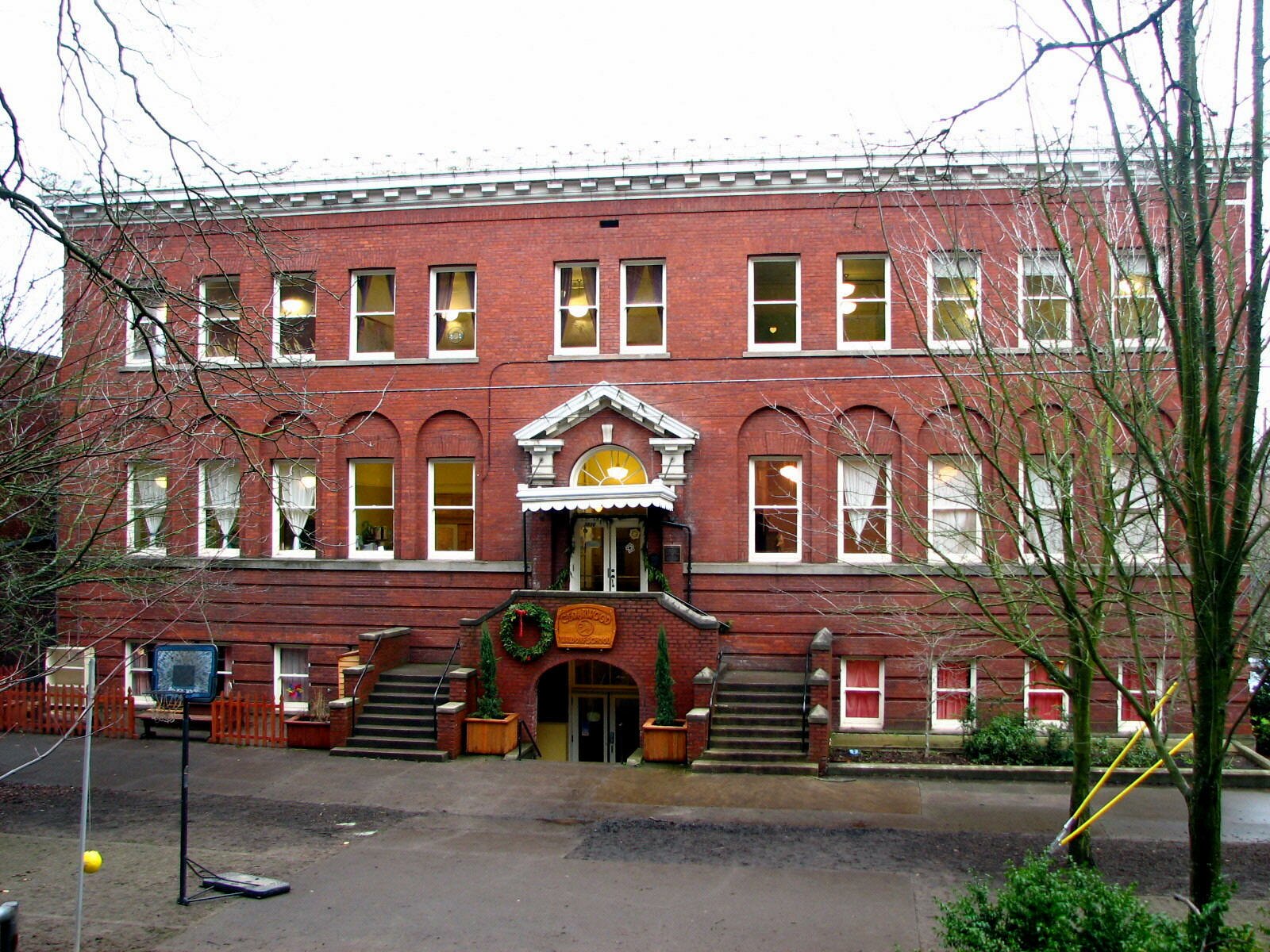
As families became more affluent, many of them moved out to Laurelhurst or Irvington. And then in the late '50s and early '60s, a series of highway projects and Portland's first urban renewal program cut the neighborhood to shreds. Olsen points out two beautiful Victorians on First Avenue that are still standing. Farther North, Mosler’s Bagel Shop and many other homes and businesses were not so lucky. Origin of the Names of Corbett, Terwilliger, Lair Hill, and Johns LandingSenator Henry Winslow Corbett was one of Oregon's prominent pioneer citizens and for many years a resident of Portland. Terwil was a station on the Oregon Electric Railway and served the Terwilliger Park subdivision. William Lair Hill was a distinguished lawyer, author, and versatile writer who moved to Oregon in his youth during the early 1850s. Note that the 'Hill' in the Lair Hill neighborhood does not refer to a physical hill but to William Lair Hill. He became one of the nation's great constitutional lawyers. Johns Landing refers to the B. P. John Furniture company, the largest of many manufacturers in the area in its industrial past, as well as architect John W. Storrs and John D. Gray, who privately transformed the area into a riverside residential and commercial development. The neighborhood, formerly known as Corbett-Terwilliger-Lair Hill or CTLH, changed its name at a meeting of its neighborhood association in 2006 to be more concise and inclusive. South Portland was the name of a 19th century community that overlapped the present day neighborhood. This area was part of historical South Portland, a district of Italian, Irish, and Jewish immigrants much of which was demolished by an "urban renewal" project in 1958. South Portland Home Styles
The terrain is flat along the river and starts rising just west of Macadam Avenue so many of the homes in the hills have views of the river and Cascade Mountain range. The same holds true for the high rise condos along the river, especially those in South Waterfront. Affordable? Condos can be found in the $200s and townhomes for just over 300,000. The South Portland Historic District was added to the National Register of Historic Places in 1998. The district is roughly bounded by Arthur, Front, Grover, Hood, and Curry Streets, and Barbur Boulevard. It has 186 buildings in the 490 acre historic district. Styles include late 19th and early 20th Century American Movements as well as Victorian. 1South Portland Home Prices
Please be aware that the above figures are subject to error and are intended as guidelines only. South Portland Homes for SaleParks in the South Portland Neighborhood
Two buildings of historical interest are located in the park.The main building was constructed out of brick in 1918 in the Modified Georgian Revival style. In 1942, the State Architect's Office extensively remodeled it to serve as the Youth Administration of the Federal Security Agency. In 1949, the Park Bureau created a Junior Museum in the building, later renamed the Children's Museum, until it was relocated to the former OMSI building in Washington Park in 2001. The smaller building, the Customs House, was built in 1921 as a branch of the county library. The building, Italian Renaissance Revival, is one of seven Carnegie-funded branch libraries in Portland. It was designed by Folger Johnson, of Johnson & Wallwork, who designed four of the seven Portland Carnegie branches. The prominent arched windows and the curved entrance flanked by columns are typical of Italian Renaissance style. On the interior, a broken pediment appears below the circular window and Corinthian columns flank the wings. The library housed a collection of books in Yiddish, German, Polish, and Italian, as well as English before being converted to an art center by the Park Bureau in the early 1950s. Today the building is used as office space for PP&R staff. At the west end of the park, a sculpture of metal boulders by Bruce West represents a rock grotto which once stood in the park and provided a shady place where older men gathered on hot summer days to play chess. It was installed in 1978 and is entitled simply BW1. The Elizabeth Caruthers Park is located in the South Waterfront community and the 2.12 acre park was acquired in 2009. It includes a bocce court, paths, splash pad, and statue or public art. The park is named for Elizabeth Caruthers, an early pioneer woman who was one of the first settlers in the southern part of the young city of Portland. Elizabeth Caruthers was born in Tennessee. In 1816 she married Joe Thomas, and the couple had one son. She later rejected her married name, and in 1847 she and the son, Finice Caruthers, came to Oregon. They settled here on the banks of the river near the abandoned 1842 Johnson cabin. Under the Donation Land Claim Act of 1850, they claimed this 640-acre section. Elizabeth died in 1857 and Finice in 1860. Their deaths, without wills or heirs, led to fraudulent claims and litigation, which reached the United States Supreme Court in 1868. There the matter was resolved in a landmark decision ruling that, under the 1850 Donation Act, a woman — married or not — had the same property rights as a man. Here are two parks located on the Willamette River:
In the 90s, volunteers organized by the neighborhood association started meeting every so often on weekends to pull invasive plants out of Butterfly Park. That project has mushroomed to include a much expanded area and many partners. Visit the South Portland Riverbanks Projects Web site to learn more. South Portland has 63 acres of park land and open spaces according to Metro and the Portland Department of Parks and Recreation. Willamette Greenway Trail
Maintained by the Johns Landing Homeowners Association, the trail is wide enough (eight feet in most places) to accommodate both bikers and walkers. Many bike commuters use the trail to travel back and forth to work downtown and at OHSU. It starts south of South Waterfront and ends at the Sellwood Bridge. Along the way are a number of marinas including the Willamette Sailing Club. The river always hold some attractions such as waterfowl, sail boats, and you may even see an eagle. Trees along the river bank block views of the river along the northern part of the trail but once they shed their leaves in the fall, the river reappears. Biking to Work in PortlandTo bike from South Portland to downtown, you have two routes: Take the off-street (no motor vehicles) path along the river and then the painted bike lanes on SW Moody. The other choice is to take SW Barbur (painted bike lanes) into downtown. Download the SW Bikes Routes map for details. You can also use byCycle bicycle trip planner, a free online tool to help both new and seasoned cyclists plan safe trips through the city. This private Web site was created by cycling enthusiasts volunteering their time, with support from Metro. Here's a video about biking in Portland.
Walking in South PortlandTwo of the better walking tours in Portland is the Lair Hill tour and the Historic South Portland tour. Below are links to the guides and a brief explanation of the tours:
Laura Foster's 3.25 mile "South Portland to South Waterfront Park Loop" is the ultimate walk if you want some exercise and history. Her 2008 book, Portland City Walks is Laura's second book about walks. Her first book, Portland Hill Walks, is a treasure and many of her fans thought she would never be able to equal that gem. But she did. Laura actually has three books about walking. Her Walk There! was published in June 2008 by Metro, the Portland-area regional government, and funded by Kaiser Permanente. Walk Score helps you find a walkable place to live. Walk Score is a number between 0 and 100 that measures the walkability of any address. Portland is the 12th most walkable city in the U.S. with a Walk Score of 66 and 57% of the residents have a Walk Score of 70 or above. The South Portland neighborhood ranks 39 out of 88 Portland neighborhoods. Below is a Walk Score for an address in the center of the neighborhood. More About South Portland
Map of South Portland Neighborhood
Fly to the South Portland Neighborhood via Google Earth
Coordinates Launch Google Earth ___________________________________1Real Estate Values Data on real estate values provided by RMLStm. Distressed properties refer to the percentage of total homes sold that were short sales and bank-owned properties.2Drive Time to Downtown Estimated commuting time obtained from Yahoo Maps and Google Maps. Drive time was calculated from a central intersection in each neighborhood to Pioneer Courthouse Square during the morning peak commute time.3Demographics Data Numbers were obtained from Census 2010 and www.portlandmaps.com.4Crime Statistics Numbers on crime were obtained from Portland Police Bureau. Violent crimes are defined as murder, rape, robbery, and aggravated assault. Crimes per 1,000 are based on reported incidents of violent crime, as well as arson, burglary, larceny, and motor vehicle theft.5Shopping and Services Numbers were determined from local directory listings and county/municipal library systems.6Biking Quality rating based on the 2007 Cycle Zone Analysis conducted by the City of Portland Office of Transportation. The six-tier ratings have been reduced to three levels: High, Fair, and Low.7School Report Card Grades Schools ratings from the Oregon Department of Education 2009-2010 performance assessment. "O" = Outstanding; "S" = Satisfactory; "I" = In Need of Improvement; NR = Not Rated
|
 Long and narrow − four-miles long along the west bank of the Willamette River − is the South Portland neighborhood. Running down the north-south length of the neighborhood along the east side is Highway 43 (also called SW Macadam Avenue). About three miles of the four miles road through the neighborhood contains commercial properties − this includes retail, restaurants, shops, and an upscale food market. Macadam Avenue is a busy street, especially in the morning and late afternoon as commuters crowd the road. Traffic backs up for blocks trying to cross the Sellwood bridge. The saving grace is that the road does have a median strip that makes driving tolerable. You can view a list of the business by visiting the
 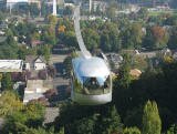 Opened in late 2006, the tram links OHSU's Marquam Hill Campus to its first building in the river blocks. The
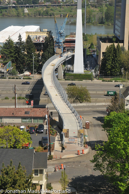
 Poina Olsen describes South Portland's population in her book entitled
 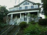 I doubt if any other neighborhood in Portland has the variety of homes that exist in the South Portland community. There are new high-rise riverfront condos, historic homes, new townhomes, apartment buildings, and newer detached single-family homes. The first homes, built in the 1870s, were mostly Victorian and home to workers at nearby docks, warehouses, and riverside industries.
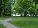
 This trail is public that is on private land and runs along the Willamette River. Designed for for bikers, runners, and walkers only