Oregon Earthquakes and Landslides
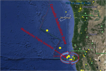 Although most Oregonians have not witnessed a large earthquake in this region, large earthquakes have occurred in the past. The Cascadia Subduction Zone lies off the Oregon and Washington coasts where two sections of the earth’s crust (tectonic plates) are colliding, with one plate sliding beneath (subducting) the other. Subduction zones have produced some of the most powerful earthquakes ever recorded, often having magnitudes of 8 to 9 or larger. Studies have found evidence that very large earthquakes have occurred repeatedly in the past on the Cascadia Subduction Zone, most recently in January, 1700. Scientists believe the Cascadia Subduction Zone is likely to produce large earthquakes in the future. Experts say it just a matter of when it will happen.
The Cascadia subduction zone runs for seven hundred miles off the coast of the Pacific Northwest, beginning near Cape Mendocino, California, continuing along Oregon and Washington, and terminating around Vancouver Island, Canada. The “Cascadia” part of its name comes from the Cascade Range, a chain of volcanic mountains that follow the same course a hundred or so miles inland. The “subduction zone” part refers to a region of the planet where one tectonic plate is sliding underneath (subducting) another. Tectonic plates are those slabs of mantle and crust that, in their epochs-long drift, rearrange the earth’s continents and oceans. Most of the time, their movement is slow, harmless, and all but undetectable. Occasionally, at the borders where they meet, it is not.
One of the chief scientists behind it is Chris Goldfinger,a paleoseismologist at Oregon State University and one of the world’s leading experts on a little-known fault line. Thanks to work done by him and his colleagues, we now know that the odds of the big Cascadia earthquake happening in the next fifty years are roughly one in three. The odds of the very big one are roughly one in ten. Even those numbers do not fully reflect the danger—or, more to the point, how unprepared the Pacific Northwest is to face it. The truly worrisome figures in this story are these: Thirty years ago, no one knew that the Cascadia subduction zone had ever produced a major earthquake. Forty-five years ago, no one even knew it existed.
An article in the New Yorker magazine July 20, 2015, issue entitled, “The Real Big One” caught the attention of many Oregonians. It described the devastation that an earthquake would cause to the state, destroying a sizable portion of the coastal Northwest along with extensive damage to Portland buildings as a result of strong and sustained ground shaking. According to the article, “In the Pacific Northwest, the area of impact will cover some hundred and forty thousand square miles, including Seattle, Tacoma, Portland, Eugene, Salem (the capital city of Oregon), Olympia (the capital of Washington), and some seven million people. When the next full-margin rupture happens, that region will suffer the worst natural disaster in the history of North America.”
Oregon Public Broadcasting’s Unprepared series is dedicated to stories that inform the community about the dangers of a megaquake, and to examining ways the region can be better prepared. Oregon Field Guide spent the last year-and-a-half probing the state’s level of preparedness. It found that Oregon is dangerously far behind many quake-prone regions in the world. The hour-long Oregon Field Guild Unprepared special premiered on October 1, 2015.
The Portland Bureau of Emergency Management has a webpage on Preparedness Resources including information on trainings and how to request a presentation on emergency preparedness. Other resources for preparedness:
- Oregon Office of Emergency Management can provide briefings on the hazards of the Cascadia Subduction Zone, the Oregon Resilience Plan, and how to prepare your community or business to be resilient to geologic hazards. They have three documents worth ordering which are Li
- Check out this “Prepare, Protect, and Recover” webpage, download some of the materials on this site and start taking the steps to be able to recover quickly from all types of hazards.
Residential Seismic Strengthening
 In 1974, a statewide building code was adopted as a means to bring the building criteria for every city and county under one all-inclusive code for the state of Oregon. This code included seismic standards for the first time. Therefore homes built before 1974 most likely do not have earthquake safeguards such as foundation bolting (house bolting), a process of attaching a house to its concrete foundation.
The City of Portland Bureau of Development Services has a program to help you make your home more secure in our next earthquake. You can download the 8-page document to help you with preparing your home for an earthquake. You may also want to read the 2014 Oregon Structural Specialty Code and visit the Oregon Building Codes Division website.
Definition of a Landslide
A landslide is a mass movement of rock, soil, and debris down a slope under the influence of gravity. There are various types of landslides, including rock falls, creep, earthflows, slumps, block slides, debris avalanches and debris flows. The size and rate of movement can vary tremendously, and as a result so can the risks to life and property. In steep terrain, landslides may transform into dangerous, rapidly moving events often referred to as debris flows, mudslides, mudflows, or debris torrents.
Scott Burns, a professor of geology at Portland State University and an authority on slides states that the three ingredients of landslides are:
- Steep slopes
- Loose soil
- Water
The Portland metro area as well as most of Western Oregon, has all three.
After disasters like the Oso landslide in Northwestern Washington state in March 2014 where upwards of 50 people were buried in a mudslide that in places the mud was 70 feet deep, a common question is why people are allowed to live in such dangerous places. On the website of Scientific American, for example, a blogger wrote, “It infuriates me when officials know an area is unsafe, and allow people to build there anyway.”
But things are rarely simple when government power meets property rights. The government has broad authority to regulate safety in decisions about where and how to build, but it can count on trouble when it tries to restrict the right to build. Often, it ends up in court .
United States Geological Survey’s landslide program in Golden, Colorado provides scientific information about geologic features and risks, but it has no regulatory authority, and state and local regulations are a patchwork. When disaster strikes, people find that their insurance policies do not cover landslides without special riders that can be ruinously expensive.
Landside Hazard Maps
After landslides killed five people in 1996 in western Oregon, the state launched a safety initiative that called for landslide hazard maps. State geologists developed taxpayer-funded maps of extreme hazard zones. But the state never formally adopted those maps after some city and county officials complained that the maps represented a regulatory headache that labeled too much area as hazardous and might restrict development.
State building codes have standards for setbacks from slopes, but they give engineers leeway to be more − or less − conservative than state standards at a specific site.
New maps outline bigger landslide-prone areas in the Portland area than previously known. The maps, released in late 2010 by the Oregon Department of Geology and Mineral Industries, identify 257 existing slides in 48 square miles. Those areas include zones of the West Hills and riverside cliffs in North Portland populated with people and homes. The largest landslide is north of U.S. 26 and the Vista Ridge Tunnel. It’s 8 million square feet − roughly the size of 90 football fields and includes parts of Washington Park.
The collection of maps highlights vulnerable portions of Multnomah and Washington counties. Landslides hit these areas hard in 1996 and 1997 with more than 300. As a result, the Legislature asked state geologists to assess landslide-prone places. The maps can help prepare people and governments for costly slides.
State geologists will create more maps of other populated urban regions. They will map the rest of the Portland area over the next several years while Astoria and Silverton maps are near completion.
You can view the new maps online by clicking here. You can also purchase a CD for $15 or for $25 you can obtain printed maps.
Homes in Peril
Destructive slides hit the region almost every winter, but the state of Oregon doesn’t require that residents at risk be warned that their homes sit in the middle of an “extremely high hazard” site. Oregon’s standard disclosure statement for residential real estate sales includes a question about whether the property is in a designated slide zone. But sellers only violate the disclosure standard if they are aware of the designation and don’t disclose it.
Homeowners who recognize landslide risk can take steps to protect their homes and family. Typical homeowners insurance policies don’t cover landslides, mudslides, flooding or earthquakes. Homeowners who know they face landslide risks can try to get a separate rider to cover landslide damage.
Determining if Your Property is Susceptible to Slides
If you are concerned about potential landslides on your property you may want to hire a geotechnical consulting company to evaluate the property. Contact the Oregon Board of Geologist Examiners (phone 503-566-2837) or the Oregon State Board of Examiners for Engineering and Land Surveying (phone 503-362-2666) for lists of registered professional consultants available for site-specific evaluations. Here are some factors to consider in determining if your property is susceptible to slides:
- Does the slope consist of loose sediment, such as sand or gravel?
- Is development in the area making the slope more vulnerable to erosion?
- Does the property have structural deformation such as large foundation cracks, misaligned doors and windows, tilted floors, or sagging decks?
- Do you have large, open cracks in driveways, curbs, and roads?
- Does the property have any failing retaining walls?
An aerial photographs of the property may reveal areas of little vegetation. This is indicative of mass wasting because after being destroyed by a landslide, the growth of vegetation is slow to resume. Another thing you may want to do is to make a landslide inventory of the area and record where past landslides have occurred.
Preventing Slides
The most important preventative step is to route runoff away from homes so it doesn’t infiltrate the ground and weaken the soil. Here are some suggestions to prevent slides:
- Make certain that your gutters and downspouts are connected to the sewer system (hopefully a separated system) or routed to a street drain basin. Alternatively, you can install a natural catch basin, which help keep storm-water runoff from flowing into rivers and streams.
- Vegetation reduces soil erosion and increases slope stability by providing different types of root systems which can help strengthen and binding the soil together. Carefully selected plants can also intercept precipitation before it hits the ground, thereby reducing runoff and excessive infiltration.
- Plant trees to stabilize hills. Geologists know that a tree is like a pump as it pulls water out of the soil as part of tree respiration. Conifers are better than deciduous since they pump water all year long.
Reward System for Ratepayers Who Keep Stormwater From Leaving Their Property
In 2000 the Portland City Council established a reward system for ratepayers who keep stormwater from leaving their property. This program, called Clean River Rewards, came into effect in October 2006 after the city launched a new utility billing system. Clean River Rewards offers residential ratepayers up to a 30 percent discount based on the extent to which they can manage runoff from roof areas. Commercial customers can claim a discount for managing runoff from both roof and paved areas. Credits are offered for having a small impervious footprint (less than 1,000 square feet), creating or maintaining tree coverage, disconnecting downspouts, installing rain gardens or drywells, and other low impact development BMPs. The City processes applications without site visits and conducts oversight via spot checks to ensure that BMPs are in effect and maintained properly.
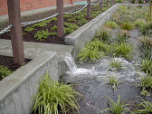
The photo above is the Mt. Tabor Middle School rain garden. Neighboring residents had experienced sewer back-ups during heavy rains as a result of excess stormwater, so a rain garden, landscaped curb extension, and sump were installed on and surrounding the school grounds. The rain garden drains three-quarters of an acre of roof area and asphalt, and it contains a variety of shrubs, grasses, and trees to slow runoff and promote infiltration. The design was intended to appear open while at the same time providing shade. A fence and shrubs were used to limit access to the feature, and the garden was designed to drain within a day with a maximum ponding depth of 6 inches. The design incorporated a variety of playful elements that allow passersby to watch the water flow through the system during rainstorms.
Washington Park Reservoirs and Landslides
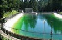
During 1894 the City of Portland Water Board built two small reservoirs, each having a capacity of about 16,000,000 – 17,000,000 gallons, situated in a small ravine in Washington Park (called City Park at the time). It was designed to supply water to the west side to include the business section. These were named Reservoir 3 and Reservoir 4 and both are still in service today having undergone a number of modifications and repairs.
A short time before these reservoirs were completed a movement of the adjacent hillside was detected, which, at first, was thought to be entirely local and of minor importance. The work of construction the reservoirs was pushed to completion, but the reservoir basins had scarcely been filled before the real magnitude of the movement became apparent. The reservoirs were emptied at once, and instrumental surveys were promptly commenced in order to determine the extent of the slide. The surveys were continued at regular intervals for a number of years and a series of test borings and open shafts were dug (33 drill borings and 22 open-shaft excavations reaching to the bed rock). The dimensions of the moving ground were at length determined to be approximately 1,700 feet from east to west, and 1,100 feet from north to south along the reservoir front (an area of approximately 30 acres). The depth ranges from 46 to 112 feet, the average being 77.8 feet. The approximate volume was 3,400,000 cubic yards and the approximate weight 4,600,000 tons.
After a study of all the observed conditions, it became clear to the Water Board engineers and the experts called into consultation, that the probable remedy was the construction of a system of drainage tunnels along the surface of the bed-rock, ant that these should be located so as to tap the underground reservoirs which had been developed by the borings and open wells. A total of 2,507 linear feet of such drainage tunnels, with timber supports, was constructed between June, 1900, and December, 1901, at at total cost of $14,161.14, or an average cost of $5.65 per linear foot for materials and labor. The volume of drainage from the tunnels was observed for the two years following their completion, and was found to range from 10,000 to 15,000 gallons per day in summer, and from 25,000 to 75,000 gallons per day in winter. At the end of two years it was decided that the drains were doing effective work and that it would be safe to proceed with the work of reservoir repairs.
Source: “A Phenomenal Land Slide” by D.D. Clarke. The paper (No. 1415) appeared in the American Society of Civil Engineers Volume LIII (1904) publication. The paper is 34 pages in length with numerous drawings.
Slides in the Portland Metro Area Since 1996
West Hill Slides of 1996-97
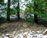
During the winters of 1996-97, when the Portland area received record rainfall, the West Hills had over 350 slides (the state of Oregon had approximately 9,500 slides). The majority of the slides caused minor damages, but a few wiped out homes and a some caused structural problems to homes. Many people were shocked to learn that their standard insurance policy didn’t cover slides.
Most slides are small and shallow, the exceptions are undated prehistoric slides under what is now the Oregon Zoo and the Washington Park Rose Garden.
Because of the ’96 slides, the City of Portland requires geotechnical engineers in slide hazard zones to drill soil samples, evaluate the firmness of underlying soils and measure depths to bedrock. The city requires geotechnical reviews at new building sites or for major remodeling projects; existing homes and buildings do not get the same scrutiny.
As a result of the renewed study, what became better known is that most of the homes in the West Hills are built on glacial loess −windblown glacial particles. The windblown silt ranges from a few feet deep in some places to 100 feet in others over basalt. Although most have survived just fine through decades of Oregon rainstorms, there can still be problems. Portland State University Bill Burns states that “The particles are not as packed together as they could be, which makes them more moisture sensitive. Combine that with the steep slopes and the risk for landslides goes way up.”
The windblown Portland Hills Silt ranges from a few feet deep in some places to 100 feet in others over basalt. On steep slopes, water provides the weight that pulls soil down. Humans make the hills less stable by unwittingly cutting into toes of old slides, or dumping new fill at the top of unstable areas. Trees act to stabilize hills.
A comprehensive study by PSU geologists following the 630-some landslides that hit the region after the heavy rains of early 1996 found that “roughly 76 percent … were linked to poorly planned land-use practices on steep or unstable slopes.” They were often triggered by “uncontrolled storm-water runoff coming from roofs and streets that contributed to adjacent slope instability.”
The report is entitled, “Landslides in the Portland, Oregon Metropolitan Area Resulting from the Storm of February 1996: Inventory Map, Database and Evaluation” and the authors are Dr. Scott F. Burns, William J. Burns, David H. James, and Jason C. Hinkle. The report was completed by the Department of Geology at Portland State University. You can download the report by clicking here.
The U.S. Geological Survey in 2006 also installed monitors at Mount Cavalry Cemetery in Northwest Portland to track rainfall and soil moisture, looking for a correlation between the two. That may allow them to better predict when the conditions are right for slides to occur.
October 2008: Southwest Home Slide Caused by Leaky Irrigation Pipes
The remains of the Hendrickson home lie at the bottom of a slope below Southwest Burlingame Place. The house slid down the hill it early October 2008. The Portland Water Bureau shut the water off two days later on a 250-foot section of pipe that serves the Southwest Burlingame Place neighborhood where the slide happened.
In an October 10 edition of The Oregonian, Scott Burns, chairman of Portland State University’s geology department stated: “More than ever, I’m convinced it was a leaky pipe” that caused the slide. Later investigation revealed that a new irrigation system had recently been installed and the system had developed some leakage of water into the ground.
Lake Oswego Slides of January 2009
Like thousands of other homeowners across Oregon, residents on Lake Oswego’s Woodhurst Place live along slopes that state geologists have mapped as landslide hazard zones. In early January 2009, three different slides occurred in the neighborhood from a recent storm. All were relatively small.
But one destroyed a million dollar home that slid down a roughly 200-foot hillside. The slide destroyed the home and forced the evacuation of 20 houses nearby. Another slide stopped against the wall of a house under construction down the street. The third covered a portion of Greenbluff Road just above Woodhurst Place.
Lake Oswego recognized the potential for landslides in the area years ago according to the geotechnical engineering firm Shannon and Wilson. The state has identified past slides on the hill and has been mapping the area for landslide hazards. Lake Oswego suggests that any homeowners concerned about potential landslides hire their own geotechnical consulting company to evaluate their home.
Washington Park Landside 2009
On the evening of January 1, 2009, a landslide was discovered completely blocking SW Sherwood Boulevard in Washington Park. Sherwood Boulevard is directly uphill (west about 100 feet) of the Water Bureau’s Washington Park Reservoirs 3 and 4 and just below the International Rose Garden’s amphitheater.
The landslide was about 40 cubic yards in diameter and about two feet deep. It completely covered Sherwood Road and blocked normal rain drainage. Portland rainfall was very heavy the night of January 1st and the newly diverted rain ran across the road, along the slide, down the hillside above Reservoir 3 until finally crossing SW Sherwood Boulevard at Washington Park Dam 3. The rainfall eroded a small amount of the hillside abutment near Reservoir 3. The water continued down the hillside and slightly flooded a Water Bureau pump house.
Crew covered the slide in plastic and sand bags later when the forecast called for 2-3 inches of rain. About 300 sandbags and yards and yards of plastic were keeping more rain from reaching into the slope and percolating down to create further slide problems.
The slide occurred in the same area that drainage tunnels were installed in the early 1900s after it was discovered that the hill was moving. It was pointed out by a city employee that the area where the slide happened was filled in years ago so to facilitate the construction of a service road that is accessed from SW Sacajawea Boulevard/Lewis and SW Clark Way. The service road is used by park crews to bring equipment into the Rose Garden area.
Light Detection and Ranging System (LIDAR)
State geologists are now mapping the state with LIDAR − light detection and ranging − a system that gathers high-resolution images of the surface of the earth. It employs lasers that let scientists see landslides that occurred decades, even centuries, before.
State and federal scientists are combining LIDAR maps with geologic data and records of past landslides to identify levels of hazards throughout Portland.
Portland Metro Area LIDAR Project
As part of its mission to assess geological hazards and natural resources to protect the life, safety and welfare of Oregonians, the Oregon Department of Geology & Mineral Industries, in partnership with the United States Geological Survey, has acquired 441.5 square miles of digital Light Detection and Ranging (LIDAR) data for portions of the Portland metro area and the Columbia River. Other government authorities, such as the City of Oregon City, also have acquired and provided LIDAR data.
The purposes of this project are to make images of the “Bare Earth” digital elevation model (DEM) derived from these LIDAR data available and searchable on the web by street address and to be able to compare and contrast these against aerial photographs, topographic maps, and 10-m DEM derived from the topographic maps, in order to educate Oregonians as to the practical and superior utility of this form of elevation information. Where earthquake and landslide hazard data are available, these hazard layers may be turned on and off.
How to Use LIDAR to Access Slide and Earthquake Information for Properties in the Portland Metro Area
Here is the link to LIDAR: http://www.oregongeology.org. You can access the interactive maps in one of three ways:
- Click on a landmark
- Type a street address or intersection within the mapped area
- View the entire metro area map
You can zoom directly to your address, if it is in the mapped area. You can also access the “Type a street address . . .” function from the “Tools” tab − click on the “GO TO FULL MAP EXTEND” icon and then click on “Zoom to Address/Scale” − a window will display in which you can type an address.
The Help text is very useful to fully understand how the LIDAR system works and it explains many of the terms.
July 2014: Portland Teams with Metro to Update Region’s Aerial Map, Image Database
The Oregonian reported in its July 25, 2014 edition that Portland is partnering with more than two dozen other cities and public agencies to gather a uniform and up-to-date aerial map and image database for the metro region.
The data have wide implications for city planners and are used to help map landslide risk areas, track the amount of vacant land in the city, provide 3D modeling for buildings and identify earthquake faults. Portland hasn’t performed an aerial survey since 2007.
The regional partners, led by Metro and Portland, are contracting with Oregon’s Department of Geology and Mineral Industries to gather the aerial photos and data. DOGAMI uses Quantum Spatial, a geo-mapping company with a Portland office, to gather the data.
In late July 2014, the Portland City Council approved the city’s $280,000 share of the project, which costs $864,000 overall. The group of public agencies pools its resources to pay for the data collection, and then each partner has access to the entire data set.
Resources
- Earthquake Tech Earthquake Tech provides customized anchoring of old Portland homes built before 1976. Most insurance companies deem this year as the cut-off for requiring proof of proper foundation connections before approving earthquake coverage.
- National Landslide Information Center This center was created by the United States Geological Survey (USGS) to collect and distribute all sorts of information pertaining to mass wasting. It is designed to assist researchers, scientists, as well as the general public.
- Oregon Coastal Atlas You can see how your home is rated for landslide risk by zooming to your property’s location. The site covers Oregon coastal counties.
- Oregon Department of Geology The state site has outdoor recreation and natural resource information, plus the largest selection of maps in the Northwest. Check out their Landslide Fact Sheet.
- Oregon Department of Geology and Mineral Industries Earthquake hazards in the Pacific Northwest.
- Preparing for Natural Disasters Natural disasters such as flood, fire, earthquake, tornado and windstorm affect thousands of people every year. This site will show you what your risks are and prepare to protect yourself, your family and community.
- Sign up to Receive New Studies The Oregon Department of Geology and Mineral Industries releases the results of its geologic studies in a variety of ways including maps, open-file reports, special papers, and brochures.
- Statewide Landslide Information Database for Oregon (SLIDO) A compilation of landslides in Oregon that have been identified on published maps. The database contains only landslides that have been located on these maps. The interactive map lets you view information on location, type, and other attributes related to identified landslides in Oregon.
- Water Environmental Research Foundation (WERF) The goal of WERF is to provide content that is appropriate for anyone interested or involved in stormwater management and development projects.